Showing 6760 items matching "rivers"
-
 Lakes Entrance Historical Society
Book, Synan Peter, Highways of Water- How shipping on the Lakes shaped Gippsland, 1989
A history of the Gippsland Lakes Victoria as a transport system for trade with in the lakes and river systems, and coastal and interstate tradeships and shipping, land settlement, waterways -
Lakes Entrance Historical Society
Book, Rob Christie, Cargo Crooked River 1984 edition, 2000
This updated edition gives a broader picture of life on the Dargo Crooked River goldfields, Illustrated with photographs and maps.mines and mining, township -
Lakes Entrance Historical Society
Book, Davidson, Rachael, The Nicholson River Railway Bridge, 2004
Research, interpretation and management recommendations for the Nicholson River Railway Bridge, East Gippsland, Victoria, by a Forestec student.bridges, transport -
Lakes Entrance Historical Society
Book, Van der Heyden Becky, Calulu Mitchell River Bridge, 2004
Research interpretation and management recommendations for the Calulu Mitchell River Bridge, near Bairnsdale, Victoria by a Forestec Studentbridges, waterways, settlers -
 Lakes Entrance Historical Society
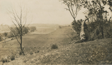
Photograph - river flats at Tambo Upper near Bruthen Victoria, 1925
Sepia toned photograph of river flats at Tambo Upper with maize crops in distance, glimpse of Bruthen VictoriaJanuary 1925 Honeymoon trip on backagriculture -
 Lakes Entrance Historical Society
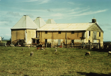
Photograph - Hop Kilns, M Fish, 1970
These hop kilns have since been destroyed by fire. Jubler was Architect of building, John French and Co Contractors. Built for James Taylor in 1882 Madres Field Hop KilnsColour photograph of Hop Kilns on Silt Jetties Road east side of Mitchell River Bairnsdale Victoriaindustry -
 Lakes Entrance Historical Society
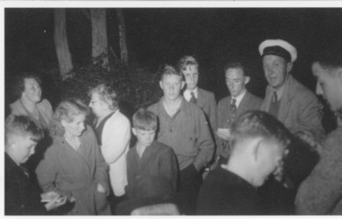
Photograph - Football
Black and White photography of a crowd at a Pig-Roast Night for LEFC Tambo River, Keith Drevermann (in cap)clubs, sports, fundraising -
 Bendigo Historical Society Inc.
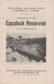
Document - EPPALOCK RESERVOIR ON THE CAMPASPE, STATE RIVERS AND WATER SUPPLY 1960
Booklet, 23 pages, detailing the construction of the Eppalock Reservoir. Printed on front cover 'State Rivers and Water Supply Commission of Victoria. Construction of the Eppalock Reservoir on the Campaspe River'. Photograph on front cover shows the Campaspe River at Eppalock. Water flowing over the existing weir. Information contained in the booklet pertains to the history of weirs along the Campaspe and the development of the Eppalock project. Black and white photos of opening ceremony of build and historical photos of weirs.bendigo, waterworks, eppalock weir -
 Lakes Entrance Historical Society
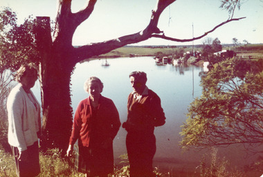
Photograph - Duncan, 1974
Colour photograph showing Jean Wilton and Eileen Potter visitors from New Zealand and George Legg of Bairnsdale standing beside the Tambo river. Both women were daughters of Captain Bob Duncan of Burrabogie which plied the Tambo river and the lakes. Johnsonville Victoriagenealogy, ships and shipping, social history -
 Kew Historical Society Inc
Photograph - Ferry on the Yarra River, circa 1953
Commercially-operated boat tours on the Maribyrnong and Yarra Rivers in Melbourne were a major tourist attraction, especially in the first half of the twentieth century. A number of companies ran ferries and motor-launches to locations such as the Riverview Tea Gardens (1909-1947) at Ascot Vale, and the Hawthorn Tea Gardens on the corner of Power Street and Riversdale Road. One of the families which ran these services was Hicks Bros, which from circa 1921 operated a ferry service from Princess Walk (Melbourne) to Studley Park. This is one of a series of 17 black and white undated photographic proofs donated to the Kew Historical Society in 2013 by the Queenscliffe Historical Museum. The series includes images of individuals, tea rooms, ferries, motor launches, ocean liners and tugs. In 1953, the owner of Hicks Bros was involved in an inquest into the drowning of a Ukrainian tourist on a ferry operated by Melbourne Ferries, a rival firm. In published reports of the inquest, reference is made to a number of photographs taken by Robert Irvine Atchison, part-owner of Hicks Bros. As the reverse of the photographs indicates copyright is held by the State of Victoria, the collection may have derived from that year.Historically significant and rare image of one of the major tour boat services which operated on the Yarra River.Faded black and white photographic proof of a ferry, possibly one of a number owned by Hicks Bros on the River Yarra. The single storey wooden ferry has a wheel that is motor driven. The popularity of ferry services is indicated by the number of passengers on board.ferries, motor launches, yarra river, studley park, princess walk, hawthorn tea gardens, tourism - melbourne (vic.), hicks bros, hicks bros launches -
 Wodonga & District Historical Society Inc
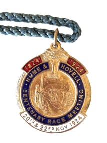
Memorabilia - Hume and Hovell Centenary Race Meeting - Albury
Great celebrations took place in Albury, NSW for the celebration of the Centenary of the Hume and Hovell expedition. The Hume and Hovell journey of discovery to Port Phillip took place during 1824-1825. On November 20, 1824, they successfully crossed the Murray River not far from Albury and proceeded on a route to Port Phillip. To celebrate the Centenary of this crossing, the city of Albury held a series of activities during the week of Sunday 16th November to Saturday 22nd November 1924. As part of these celebrations the Albury Race Club held a special race meeting conducted on Thursday 20th and Saturday 22nd November 1924. This badge was produced as a memorabilia for that meeting. Prize money over the two day meeting totalled over £3,000. The star events were the Centenary Cup of I mile and 3 furlongs with a prize of £1000 (one thousand pounds) and a Gold Cup valued at one hundred guineas, donated by Mrs. Jas. Mitchell of Tabletop, and the John Campbell Handicap of one mile carrying $500 and trophy valued at 50 guineas donated by the chairman of the Club, Mr. J. Campbell. A gold whip donated by Mr. Norman Crow was presented to the jockey riding the Cup winner. This item is significant because it is an example of memorabilia produced for the centenary celebrations for the Hume and Hovell Expedition.An enamelled fob medallion featuring a central image with a tree at the top and text. The tree is the Hovell Tree at Albury. The central image is of indigenous man facing Albury’s civic buildings with the Murray River in between. The fob is attached to a blue twisted cord.1824 1924 HUME & HOVELL CENTENARY RACE MEETING 20th and 22nd Nov 1924 On back: 244B SIMPSONhume & hovell, hume & hovell centenary, albury race club -
 Kew Historical Society Inc
Photograph - Victorian Canoe Club, Dight's Falls, Studley Park, 1920-30
Canoeing on the River Yarra at Melbourne was an important and widespread recreational pursuit for Melbournians, especially in the first half of the twentieth century. The Victorian Canoe Club was formed in 1912 at a meeting in Melbourne and its first committee elected in the same year. Records indicate that the Club continued into at least the 1950s .The album has historic and social significance as a record of recreational activities (as well as canoe making) in the early years of the twentieth century. It has local significance as the site of the headquarters of the Club was in Studley Park. A number of photographs in the album provide vistas of Kew on the Yarra that are otherwise unavailable.One of 24 labelled photos in part album, originating from the Victorian Canoe Club, which had its headquarters in Studley Park, Kew. The album includes a photographic record of canoe construction and also locations in Studley Park and Kew where the canoes were used. The subject of this photograph is identified as 'Dight's Falls, Studley Park'.The view is from above and shows an early trestle bridge across the Falls on which people, possibly members of the Club, are walking or standing. The point of view would appear to be looking up river towards Fairfield."Dyghts Falls, Studley Park"victorian canoe club, river yarra, burke road -- kew (vic.), dight's falls -- fairfield (vic.), dight's falls -- kew (vic.), dight's falls -- yarra river -
 Bendigo Military Museum
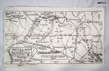
Map - TRENCH, BATTLE & ORDNANCE MAPS FRANCE WW1, All 1918
(.2) Areas on map relate to : The Hindenburg line on the left, from the top, Bony to Bellicourt to Bellenglise, Estrees to Brancourt. (.3) The River Somme runs through from top corner left bottom corner right. Main areas are Belloy, Picquigny, Bertangles, Montieres. The map finishes just short of “Amiens” Items in the collection relating to F.A.W Hutson No 3539 AIF. refer Cat No 922 for his service history.(.1) Map on paper showing the “Battle of August 1918”, Map C, The Advance to “Lions & Proyart”. (.2) Trench map, gauze lined, sheet 62B N.W, trenches corrected to 8.2.1918, German trenches in blue, scale 1:20,000, France. (.3) Ordnance survey map, May 1918, France, Edition 1, sheet 62 E N.E, scale 1:20,000, a canal and river runs through the centre(.2) On rear hand written “62 B N.W” (.3) On rear hand written “D.M.F 62 E N.E”august 1918, maps, somme -
Glenelg Shire Council Cultural Collection
Souvenir - Souvenir Program - Glenelg River Bridge Opening Nelson, Victoria, c. 1997
Bowerbird Museum4 Page souvenir program, opening of Glenelg River bridge at Nelson, 21 September 1997. Black and white image of completed bridge on front cover; images of construction phases back cover. Details of opening ceremony and history of Glenelg River crossing at Nelson, inside pages. -
 Federation University Historical Collection
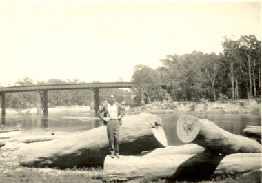
Photograph - Black and White, Frank Wright standing on felled trees, 1940s?
Frank Wright was a renown resident of Smeaton, where he was born on 2 August 1901. He lived at Laura Villa, and attended Smeaton State School. His father William was a gold miner and his mother's name was Sarah. Their family won many singing and instrumental awards. Frank was tutored by Percy Code and was awarded a gold medal for the highest marks in the ALCM examinations in the British Colonies at the age of seventeen years. He became the Australian Open Cornet Champion by the age of eighteen. A year later, Frank conducted the City of Ballarat Band, and later the Ballarat Soldiers’ Memorial Band. He formed the Frank Wright Frisco Band and Frank Wright and his Coliseum Orchestra. These bands won many South Street awards, and Frank as conductor won many awards in the Australian Band Championship contest. In 1933 Frank Wright sailed to England to conduct the famous St Hilda’s Band and was later appointed Musical Director of the London County Council, where he organized many amazing concerts in parks, in and around the London district. He was made Professor of Brass and Military Band Scoring and conducted at the Guildhall of Music and Drama. Frank was often invited to adjudicate Brass Band Championships around Europe, in Australia, including South Street and in New Zealand. The Frank Wright Medal at the Royal South Street competition is awarded to an individual recognized as making an outstanding contribution to brass music in Australia.Black and white photograph of a man dressed in a suit standing on the trunk of a large felled tree. Around him are other fallen tree trunks, all located on the banks of a river. In the background is a bridge spanning the river and on either side of the water are the tall trees of a forest. The man is Frank Wright.frank wright, felled trees, forest, bridge -
 Kew Historical Society Inc
Photograph - Zig-zag Bridge, Kew, Henry Beater Christian, 1920s
An item from an outstanding and diverse photographic collection, assembled by members of the Christian family of Pakington Street, Kew, comprising professional and amateur photography, depicting individuals, natural and settled environments and the interactions between these worlds. Many of the photographs vividly capture the worlds of three generations of men - Henry Christian, his son Orlando Henry Beater Christian, and his grandson of Henry Beater Christian. The most important photographer was the youngest, Henry Christian, who was a keen explorer, not just of his immediate environment but also of the Victorian wilderness. His major opus is contained in two albums in which he records, sometimes in majestic detail and on other occasions the intimate features of the natural world. His photographic travels during the 1920s, often in solitary ramblings but on other occasions with companions, recall the heroic landscape photography of an earlier era, pioneered by Nicholas Caire. In addition to their aesthetic value, the albums are historically significant records within the State of Victoria, of what is now a distant point in time, and of places that have become radically altered through human intervention.Sepia photograph of the wooden trestle Zig-Zag Bridge across the River Yarra. The bridge was built in the 1870s to transport stone from the west side of the Yarra to the east side. The stone was used in the construction of the Kew Asylum. The bridge continued to link the two asylums on each side of the river. yarra river -- kew (vic), zig-zag bridge -- kew (vic.), henry beater christian, christian-washfold collection -
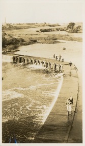
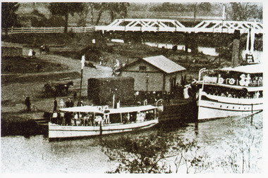 Lakes Entrance Historical Society
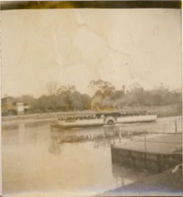
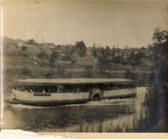
Photograph - Lady Harriet, 1912 c
Black and white photograph showing steamer Lady Harriet on left, S S Gippsland on right at Bairnsdale wharf on Mitchell River, railway track behind Lady Harriet, horse and jinker at wharf, shed at wharf, road bridge over river with people in background. Bairnsdale Victoriaships and shipping, boats and boating, wharfs -
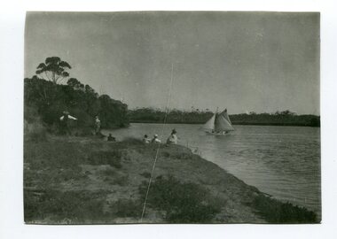 Orbost & District Historical Society
black and white photograph, C1900
This is a fishing party at Bream Point, Marlo C 1900.Marlo has always been a popular destination for fishing. This is a pictorial record of an early fishing group at Marlo.A black / white photograph of a small group - possibly a family - fishing off a river bank. A small ketch is on the water.on back - Near Bream Pointmarlo-fishing recreation -
 Kiewa Valley Historical Society
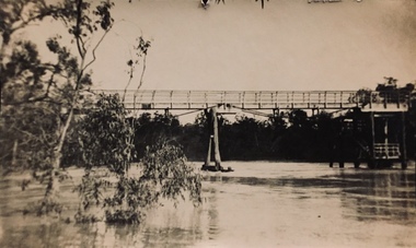
Photograph - Kiewa River in flood at Clover Dam
As part of the push to cut electricity costs and diversify supply, the Victorian Government (circa 1930) implemented the conversion strategy from mainly brown coal supply to hydro - electricity. The Kiewa Hydroelectric Scheme became the largest scheme of its kind in the State Of Victoria and the second largest scheme in Australia. Clover Dam and Power Station were built by the State Electricity Commission of Victoria as part of the Kiewa Hydro Electric Scheme from the late 1930's to the early 1940's. This dam was constructed to supply water to feed four turbines (62 mega watts) at the West Kiewa Power Station. This was at the forefront of sustainable "Green" energy. Costs associated with power supplies is still a major incentive of governments, however environmentally friendly alternatives such as wind and nuclear have also made inroads. The Kiewa valley and its surrounding alpine catchment were looked at(Victorian State Government), from the beginning of the twentieth century as a source of alternate power for an ever-increasing demand for electricity by growing population and heavy industrial areas within Melbourne City and State regions. Construction of dams, such as Clover Dam provided the large quantity holding areas of water required to turn the turbines at the various power stations to provide the electricity needed. The impact of these controls by moderating water run-off from the alpine regions is beneficial in reducing flooding from thawing of snow on the alps. This by-product allows agriculture and grazing to be less vulnerable to seasonal flooding thereby resulting in a more stable annual production level.Black and white photograph of Clover Dam with Kiewa River in flood. .5mm white boarder on 3 sides of photo.Handwritten on back of photograph in black pen - Kiewa in flood. Clover Dam.clover dam, secv -
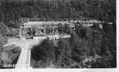 Kiewa Valley Historical Society
Photograph - Clover Dam
As part of the push to cut electricity costs and diversify supply, the Victorian Government (circa 1930) implemented the conversion strategy from mainly brown coal supply to hydro - electricity. The Kiewa Hydroelectric Scheme became the largest scheme of its kind in the State Of Victoria and the second largest scheme in Australia. Clover Dam and Power Station were built by the State Electricity Commission of Victoria as part of the Kiewa Hydro Electric Scheme from the late 1930's to the early 1940's. This dam was constructed to supply water to feed four turbines (62 mega watts) at the West Kiewa Power Station. This was at the forefront of sustainable "Green" energy. Costs associated with power supplies is still a major incentive of governments, however environmentally friendly alternatives such as wind and nuclear have also made inroads. The Kiewa valley and its surrounding alpine catchment were looked at(Victorian State Government), from the beginning of the twentieth century as a source of alternate power for an ever-increasing demand for electricity by growing population and heavy industrial areas within Melbourne City and State regions. Construction of dams, such as Clover Dam provided the large quantity holding areas of water required to turn the turbines at the various power stations to provide the electricity needed. The impact of these controls by moderating water run-off from the alpine regions is beneficial in reducing flooding from thawing of snow on the alps. This by-product allows agriculture and grazing to be less vulnerable to seasonal flooding thereby resulting in a more stable annual production level.Black and white photograph of Clover Dam buildings and Kiewa River. Has a .4cm white border around photograph Printed on bottom left corner of photograph in white - Clover Flatclover dam, secv -
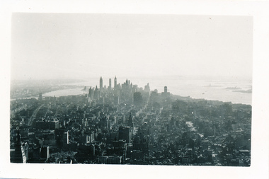 Mission to Seafarers Victoria
Photograph - Photograph, Black and white, Allan Charles Quinn, Down Town New York, 10 September 1949
Allan Charles Quinn was a member of the Merchant Navy from aged 16 as well as being a trained photographer. This photograph was taken during his travels through America whilst still being associated with the Merchant Navy.This photograph captures the New York skyline of 1949 in very clear detail. This photograph is part of a larger collection, know as the Allan Charles Quinn collection, which provides a photographic autobiography of the life of an individual seafarerBlack and white photograph of Manhattan and Hudson River showing skyscrapers in the background with other buildings and general cityscape in foreground.Blue handwritten ink on reverse of photograph "10-9-49".photographs, mission-to-seafarers, seamen, hudson-river, skyscrapers, new-york, allan-charles-quinn, manhattan, skyline, cityscape -
Glenelg Shire Council Cultural Collection
Negative - Negative - Glenelg River, Nelson, Victoria, c. 1936
Transparency for black and white photo. Two ladies looking through trees at Nelson, Vic Glenelg River in background -
Glenelg Shire Council Cultural Collection
Negative - Negative - Glenelg River Nelson, Victoria, c. 1936
Negative for a black and white photograph. Image shows Mouth of Glenelg River at Nelson, Victoria. Woman standing in the dunes. -
Glenelg Shire Council Cultural Collection
Negative - Negative - Glenelg River, Nelson, Victoria, Miss Zillah Maschmedt, photographer, c. 1936
Negative for a black and white photograph. Image shows Glenelg River, Nelson, Victoria, sand dunes at mouth in distance. -
Glenelg Shire Council Cultural Collection
Slide - Slide - Glass Plate Negative, 1890-1910
Glass plate negative. Group of men and women standing on bank of river. Mostly grassland, very few trees. -
 Eltham District Historical Society Inc
Photograph, Yarra River, Sweeneys flats, 1994c
Colour photogrpah of oblique aerial view looking east over Yarra River and Sweeneys flats c.1994sweeneys lane, yarra river, culla hill, thomas sweeney, aerial photographs -
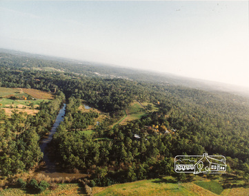
 Orbost & District Historical Society
plans, 1966?
These survey plans are a useful research tool.A flat green fabric folder with a white label with "SNOWY RIVER FLATS" hand-written in black. It contains plans.plans-survey snowy-river-flats department-crown-lands-victoria -
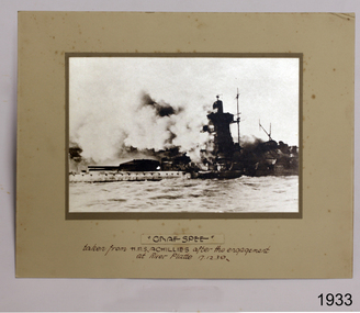 Flagstaff Hill Maritime Museum and Village
Photograph
Photograph of Graf Spee taken from HMAS Achilles after the engagement at River Platte 17 Dec 1939flagstaff hill, warrnambool, shipwrecked-coast, flagstaff-hill, flagstaff-hill-maritime-museum, maritime-museum, shipwreck-coast, flagstaff-hill-maritime-village, photograph of graf spee, photograph, graf spee -
 Port Melbourne Historical & Preservation Society
Photograph - Loading gypsum, Dock No 6, Yarraville, Glen Stuart, 17 May 2003
Colour photo of cranes used for loading gypsum on Dock No 6 Yarraville, taken from across Yarra Riverpiers and wharves