Showing 3069 items matching "scales"
-
 Bendigo Military Museum
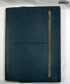
Administrative record - FOLDER, 2) & .3) Geographical Section, General Staff, No 4080 War Office 1941 et al, Navigator's Log Book, 2) & .3) 1941
.1) Navigator's Log Book, hard cover, blue colour buckram with dark blue paint on front cover. Back end paper includes a pocket for maps & has a Conversion Table & Nautical Miles, Statute Miles, Kilometres, tables in black print on beige paper included. Stiff card divider. .2) Map folded, black printing on beige paper. Gibraltar Scale 1:1,000,000 at 56 degrees N. .3) Map folded, black printing on beige paper. Algeria Scale 1:1,000,000 at 56 degrees N. .4) Pencil grey lead, timber colour. Stamped into pencil: HB Commonwealth of Australia..1) Hand written in black ink on front end paper: Wreck at Cape Juby. In pencil: S2 / MZ / W2 / 1Z . 35N .2) Hand written in blue pencil: Atlantic. Blue & red ink & lead pencil notations over map. .3) Hand written in blue pencil: Mediterranean. Blue & red ink numerous notations over map.documents - maps/records, military history, passchendaele barracks trust -
 Flagstaff Hill Maritime Museum and Village
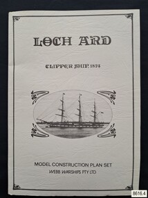
Document - Ship Model Plans, Webb Warships Pty Ltd, Loch Ard Clipper Ship, 1874; Model Construction Plan Set, 1978
The plans are presented in a keepsake folder. They show marks of sections copied and assembled together. Overall, the plans are similar to those drawn by Mr P Webb to the order of the Loch Ard Shipwreck Centenary through Mr P Williams, the organizer of the Centenary competition. “The details were based on all available information which resulted in considerable historical research…and received favourable comment from model makers because of their attention to detail…In excess of 650 sets of plans were sold before entries closed…Many plans were probably purchased by collectors and interested persons for historical reference. An illustrated historical story sheet…was prepared and enclosed with the plans…” (‘Loch Ard Shipwreck Centenary 1878-1978 Report’, November 1978). An example of the attention to historical detail on the plans is the inclusion of the following useful information about the original vessel … Tonnage….1,693 G.R.T., 1,624 N.R.T. Dimensions, Builders….Charles Connell & Co., Ltd., Scotstoun, 1873. Owners….General Shipping Co., Glasgow, (Aitken Lilburn & Co., Ltd.), and the ship’s fate. The plans, in conjunction with the scale Ship Model of the LOCH ARD also on display, are of interpretive significance to Flagstaff Hill Maritime Village. The plans provide historical and technological context to artefacts from the shipwreck, increasing understanding and appreciation of those objects. Flagstaff Hill’s collection of artefacts from LOCH ARD is significant for being one of the largest collections of artefacts from this shipwreck in Victoria. It is significant for its association with the shipwreck, which is on the Victorian Heritage Register (VHR S417). The collection is significant because of the relationship between the objects, as together they have a high potential to interpret the story of the LOCH ARD. The LOCH ARD collection is archaeologically significant as the remains of a large international passenger and cargo ship. The LOCH ARD collection is historically significant for representing aspects of Victoria’s shipping history and its potential to interpret sub-theme 1.5 of Victoria’s Framework of Historical Themes (living with natural processes). The collection is also historically significant for its association with the LOCH ARD, which was one of the worst and best known shipwrecks in Victoria’s history.Model ship plans for building the LOCH ARD. The three sets of plans are presented in a textured cream card folder with the supplier’s details and an oval cameo drawing of the LOCH ARD. The plans are detailed and drawn to scale. They and printed on good quality paper with details, scale and legends. Sheet 1: Sails and Rigging Sheet 2: Lines, Decks and Details Sheet 3: Masts and Spars Details include deck fittings, the wheel, lights and the shipping company’s house flag. The ship model plans are copyrighted in 1977 and 1978 to Webb Warships Pty Ltd. The folder has details of four locations; Australia, USA, UK and New Zealand. Sheet has a handwritten inscription.On Folder: "LOCH ARD CLIPPER SHIP, 1874, MODEL CONSTRUCTION PLAN SET, WEBB WARRIORS PTY LTD." "CONTENTS COPYRIGHT (C) 1978, WEBB WARSHIPS PTY LTD" "WEBB WARSHIPS PTY LTD, PO BOX 50, WILLIAMSTOWN, VICTORIA 3016, AUSTRALIA" Handwritten inscription on sheet 3: "834" "THE FLOATING DRYDOCK, PO BOX 16066, PHILADELPHIA, PENNA. 14114, USA" "SAMBROOK MARINE (PLANS), 84 BROAD ST. TEDDINGTON, MIDDLESEX, UK" "BYMODELS, PO BOX 3037, FORBURY, DUNEDIN, NEW ZEALAND" flagstaff hill, warrnambool, shipwrecked coast, flagstaff hill maritime museum, maritime museum, shipwreck coast, flagstaff hill maritime village, great ocean road, loch line, loch ard, captain gibbs, eva carmichael, tom pearce, glenample station, mutton bird island, loch ard gorge, ship model plans, loch ard model plans, sailing ship, loch ard centenary, webb warriors pty ltd, 1977, 1978, centenary competition -
 Bendigo Military Museum
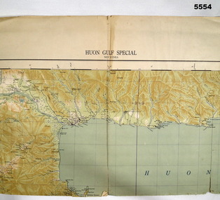
Map - MAP, HUON GULF AREA, Aust Survey Corps et al, Aug 43
Refer Cat 5547 - Matheson.This is a single sided map, printed in colour. Scale 1:253,440, 4 miles to an inch, grid squares are 10mm x 10mm. Top right side shows Finschafen. Top centre is Lae, Middle is Salamau. Bottom is Lasanga Island. Top left vicinity is Nadzab and Markham River.There are four "corner" marks in pencil. Two on land and two out in the gulf.ww2, new guinea, map -
 Bright & District Historical Society operating the Bright Museum
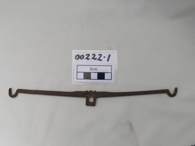
Scales, Weighing
Metal suspension scales. Very rusted. 00222.1 : Metal arm - brass 00222.2 : Forked handle - brass. 00222.3 : Larger dish - of unknown material, has a broken piece 00222.4 : Smaller dish - 0f unknown material 00222.5 : Steel fulcrum rod - Possibly manufactured by Aldo Gios.weighing scales, goldfields, chinese, buckland valley -
 Federation University Historical Collection
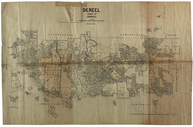
Plan, Dereel Parish Plan, 1928, 16/07/1928
Parish Plan of Dereel showing crown allotments, dimensions, crown grantees, dates of grant. Scale 1:31,680 WGS 84 Centroid 37 degrees 48 feet 33 inches S 143 degrees 41 feet 46 inches S NS: 6.3km EW: 15.2kmdereel, parish plan, p. mclachlan, rifle range, j. bower, dereel lagoon, t. mellington, j. mcdonald -
 Bendigo Historical Society Inc.
Map - CAMPBELL COLLECTION: BENDIGO AND DISTRICT MAPS, 2-2-29
Map. Wellsford, Parishes of Wellsford and Axedale, Scale 20 chains to 1 inch. Total area 4994 acres. Prepared in W.P.B. from A and P Plans, by W.J.G.2-2-29. Top left of map are directions to Fosterville, Huntly & Bendigo. (number 361 in map cupboard 1)W.J.Galbraithmap, bendigo, parish plan -
Bendigo Historical Society Inc.
Map - CAMPBELL COLLECTION: BENDIGO AND DISTRICT MAPS
Map. Whirrakee, Parish of Whirrakee. Total area of map 4419 acres. Scale 20 chains to 1 inch. 23 allotments are sold, Eucalypt oil distillery on lower portion of map. Prepared in W.P.B. from Assessor's plan and Parish Plan. (number 350 in map cupboard 1)map, bendigo, allotments -
 Bendigo Historical Society Inc.
Tool - DONEY COLLECTION: 8'' X 8'' MASKING BOARD FOR CROPPING AND PHOTOGRAPHIC PRINTING
Adjustable metal 8"x 8" masking board for cropping and photographic printing Imperial scale, excellent condition Adjustable frame for variable cropping of prints; maaximum printing 240mm x 190mm (8.5"x 6.5") An Elande product manufactured by Lee & Diverell, Mitcham, Victoria, AustraliaELanDE product manufactured by Lee & Diverell, Mitcham, Victoria, Australia -
 Bendigo Historical Society Inc.
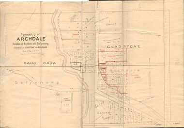
Map - JACK FLYNN COLLECTION: TOWNSHIP OF ARCHDALE, /08/1904
Map: Township of Archdale, Parishes of Archdale and Dalyenong, Counties of Gladstone and Kara Kara. Scale 4 Chains to 1 Inch. Has attached letters relating to land transfers between the Estate of Kate Sanderson and Barry Frederick Mortlock also between Matilda Jane Sanderson and A. O. Proctor.J. K. Spark Narrister & Solicitor, Formerly Mitchell, Monotti & Sparkmap, gladstone, township, archdale, dalyenong, gladstone, kara kara -
Whitehorse Historical Society Inc.
Map, Waverley, c1985
Map of Waverley, including Box Hill Soiuth, Blackburn South, Vermont, Vermont South, Burwood East, Burwood, Ashburton, Mount Waverley, Glen Waverley, Oakleigh South, Clayton North and Mulgrave.Map of Waverley, including Box Hill Soiuth, Blackburn South, Vermont, Vermont South, Burwood East, Burwood, Ashburton, Mount Waverley, Glen Waverley, Oakleigh South, Clayton North and Mulgrave. UBD map issued by Nicholls Gledhill Real Estate Agents. Scale 1:50,000.Map of Waverley, including Box Hill Soiuth, Blackburn South, Vermont, Vermont South, Burwood East, Burwood, Ashburton, Mount Waverley, Glen Waverley, Oakleigh South, Clayton North and Mulgrave. blackburn south, burwood east, vermont, vermont south, forest hill -
 Whitehorse Historical Society Inc.
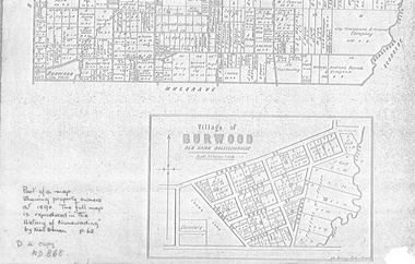
document - Map, Village of Burwood, 1892
Map on the village of Burwood.Village of Burwood : old name Ballyshanassy (with southern section of Nunawading). Area bounded by Chapman, Ireland and Evans Streets). Victorian Shire Map. co. 26 November 1892. Scale: 8 chains = 1 inch. The full map is reproduced in 'The History of Nunawading' by Niall Brennan, p. 62.Map on the village of Burwood.burwood, land settlement -
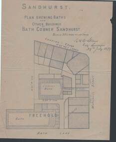 Bendigo Historical Society Inc.
Document - PLAN OF BATH CORNER: SANDHURST 1879
Buff coloured plan showing Baths and other buildings at Bath Corner Sandhurst. Scale 50 Links to an Inch. Plan area Charing Cross, Mitchell Street and Bath Lane. Plan has bearings on it. Signed by G R B Steane, City Surveyor, 29th July 1879.place, building, commercial, plan of bath corner sandhurst 1879, charing cross, ladies' bath, g r b steane -
 Beechworth Honey Archive
Hand-Drawn Map Centred on Worouly by Frank Lebbell Frost December 1916
This is one of the maps drawn by Frank L. Frost while he was beekeeping in North-East Victoria. This particular map may be reference in the "Wooden" Diary on page 10.Hand-drawn map centred on Whorouly and showing other towns, including Oxley, Byrne, Edi and Whitfield. Details the local flowering eucalypts. Scale is each red square equals three miles. Drawn with black pen and grey lead on paper. Grid and other features are marked in red.hand drawn, hand-drawn, map, oxley, byrne, whitfield, edi, frost, beekeeping, beechworth honey -
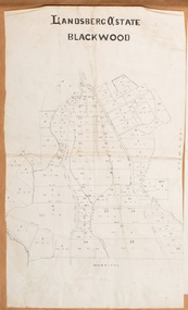
![Map, Late the Property of Robert Lawson Esq. [Landsberg Estate Blackwood]](/media/collectors/5e461d8021ea67224c82f2a1/items/67763722eb6d2cbd24dff14f/item-media/677637b7eb6d2cbd24dff29d/item-fit-380x285.jpg) Bacchus Marsh & District Historical Society
Bacchus Marsh & District Historical SocietyMap, Late the Property of Robert Lawson Esq. [Landsberg Estate Blackwood]
The date this map was created has not been identified. It was possibly created at the time the Landsberg Estate near Blackwood was subdivided and sold into smaller lots in December 1886. This land once belonged to Robert Lawson who died in 1869. Lawson was a well known school teacher who founded Scotch College in Melbourne before setting up a school near Blackwood. This map is similar to another map in the BMDHS collection titled 'Landsberg Estate Blackwood' Victorian Collections record 459 and was possibly produced at the same time.Single page map showing land allotments which made up the Landsberg Estate near Blackwood. Scale 20 chains to 1 inch. The map is pasted into a bound volume containing 76 maps or plans in total. High resolution digital image stored on BMDHS computer network. At the top of the map: 'Late the Property of Robert Lawson Esq.'bacchus marsh victoria maps, landsberg estate blackwood -
 Bacchus Marsh & District Historical Society
Map, Landsberg Estate Blackwood
The date this map was created has not been identified. It was possibly created at the time the Landsberg Estate near Blackwood was subdivided and sold into smaller lots in December 1886.Single page map showing land allotments which made up the Landsberg Estate near Blackwood. Scale 20 chains to 1 inch. The map is pasted into a bound volume containing 76 maps or plans in total. High resolution digital image stored on BMDHS computer network. bacchus marsh victoria maps, landsberg estate blackwood -
 Bacchus Marsh & District Historical Society
Map, Plan of Survey of Part of Crown Allotment 9, Parish of Korkuperrimul, 1890
This map documents a transfer of an allotment of land in Clarke Street Bacchus Marsh in 1890. Clarke Street is located on the eastern side of Bacchus Marsh not far from Main Street and Crook Street. It is now known as Candeloro Street. The map indicates J. Booth as the owner of the land and H. Simpson as the occupier. Next to this allotment is a an allotment of land owned by J. Elmore,Single page map showing Crown allotment 9, Parish of Korkuperrimul, County of Bourke. Scale 100 feet to inch. Part of a set of maps which are pasted into a bound volume containing 76 maps or plans in total. High resolution digital image stored on BMDHS computer network. At bottom of map: I hereby certify that I have made this survey expressly for the purpose of an application under the Transfer of Land Statute that this plan is correct. Barry B???, Lic. Surveyor, 16.10.90bacchus marsh victoria maps, clarke street bacchus marsh maps -
 Bendigo Military Museum
Manual - DRAFT SPECIFICATIONS FOR TOPOGRAPHIC MAP SERIES, Specifications for 1:50000 and 1:25000 maps produced in Australia, Circa 1973
These draft Specifications set out the Standards for the production of topographic maps within the Commonwealth of Australia at scales of 1:50000 and 1:25000 and are designed to satisfy the basic requirements of both civil and military map users.Hard cover, cloth, Red, 11 Annexes, Supplementary documents.royal australian survey corps, rasvy, fortuna, army survey regiment, asr -
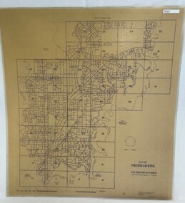 Greensborough Historical Society
Poster - Map, City of Heidelberg, 1984
Numbered grid map of the City of Heidelberg showing municipal boundaries in 1984 . Scale 1 inch to 160 feet. Side 2: MMBW Plans Yarra 2000, note Ward boundaries not updated on this plan.An example of hard copy plans from the 1960s. Mainly from the Shire of Diamond Valley era (1964-1994).Map printed on brown paper and laminated. Double sided.city of heidelberg, mmbw -
 Warrnambool and District Historical Society Inc.
Map, Soil conservation authority:plan of high water marks at Lady Bay Warrnambool, 1984
This map documents the changing state of Lady Bay from around 1870 until 1976. It depicts the changing high water mark over that period and the main outlet of the Merri River in 1872 and 1976.This map provides a useful and significant insight into the ever changing face of Lady Bay from the 1870’s through to 1980’s. Cream paper map drawn with black ink showing Lady Bay and South Warrnambool section of Warrnambool. In lower RH corner Soil conservation AuthorityPlan of High water marks at Lady Bay Warrnambool. Drawn P.D. 19.1/84. Scale 1:3600. Written on back in black pencil: Lady Bay Historical HWM lady bay map, merri river 1872- 1976, merri river 1872- 1976, history of warrnambool -
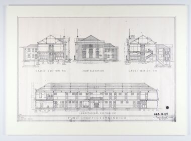 City of Greater Bendigo - Civic Collection
Work on paper - Architectural Drawing, City of Bendigo, Public Offices Bendigo, 23 November 1928
Mounted plan drawings for Public Offices in Bendigo.Cross Section A-A / Side Elevation / Cross Section B-B / Longitudinal Section C-C / R.M.B. / Scale: Eight feet - One Inch / PUBLIC OFFICES BENDIGO ? P.B.B. 5.24 / (signature) / Chief Architect / 23.11.24city of greater bendigo administration item -
Glenelg Shire Council Cultural Collection
Work on paper - Public Baths for the Borough Council of Portland
Colour plans showing the public baths of Portland. Top right is the title. Depicts the South Side Elevation, West Front Elevation and swimming area as well as several sectionsThis is the plan ***** to the Contrct / entered into this Tenth day of October 1888 / for the erection of the new Baths for the Borough of / Portland Top Right Public Baths / For the / Borough Council / of / Portland / Wm Mackay / archt Scale 16 Feet TO 1 Inchportland baths, borough of portland, william mackay -
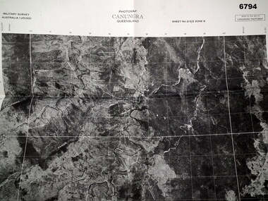 Bendigo Military Museum
Map - MAP, CUNUNGRA, QLD, Royal Aust. Survey Corps, 1955
Canungra was the Jungle Warfare Training Centre (JTC) before and including 1968. Item in the collection re Lt.Col. Swatton refer Cat No 6719.2P for his service details.This is a full size air photo map. It is black and white. Some natural features are labelled with white printing. The air photo has a white border of approx 6.5 cms size. Map information is printed in black ink around all four borders.Map data = Military survey Australia 1:25,999 Sheet No. 213/2 Zone 8. Scale 1:25,000. Date = The air photo was taken Jan 1955. Map produced by R.A. Survey Corps 1955.passchendaele barracks trust, survey map -
 Bendigo Military Museum
Print - PRINT, FRAMED, WW1, Reader's Digest (Australia) Pty Limited, 2015
From information Book - "Readers Digest'/ Gallipoli/ 25th April 1915 - 9th January 1916/ Centenary Commemorative Prints." Collection of 20 prints. Refer Cat No. 7300.Framed print. Print - colour print on paper. MAP ANZAC - map scale 1:10,000 elevations in feet. Depicts the line of Australian and New Zealand Front Trenches. Intended as a working document. Frame - Black plastic framing with glass front and MDF board backing with adhered black paper.Details below print - in black ink. "GERALD R. CAMPBELL Anzac: Map of Gallipoli Peninsula, 1916"framed accessories, prints, ww1, gallipoli, centenary -
 4th/19th Prince of Wales's Light Horse Regiment Unit History Room
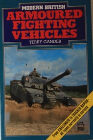
Book, Terry Gander: Modern British Armoured Fighting Vehicles, 1986 (exact)
This book gives details of armoured fighting vehicles in service with the British Army of the eighties. Included are tracked and wheeled reconnaissance vehicles such as Scorpion, Scimitar and Fox, armoured personnel carriers, command, engineer and signals vehicles, bridge layers and others. Specifications and performance details are accompanied by constant-scale plans and photographs.ISBN 0-85059-836-2photographs, armour, armoured fighting vehicles, british army, specifications, terry gander, photographs, armour, armoured fighting vehicles, british army, specifications, terry gander -
 Federation University Historical Collection
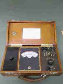
Scientific Instrument, Volt/Ammeter Testing Set
A testing set built into a polished timber box with a hinged lid and a carry handle. The semicircular scale reads 1-150. Four voltage ranges and four current ranges are obtainable with selector switches. Connecting diagram inside the lid. Three currentl shunts in storage compartment. Serial Number 52204scientific instruments, testing set, voltmeter, ammeter -
Bendigo Historical Society Inc.
Map - CAMPBELL COLLECTION: BENDIGO AND DISTRICT MAPS, 22-3-29
Map. Marong, Parishes of Marong, Lockwood and Mandurang, Scale 20 chains to 1 inch, Total area 5106 acres. Crusoe Reservoir & Viaduct and water race. Compiled in W.P.B. fro Field Survey and Parish Plans. B.W.L.22-3-29 (number 389 in map cupboard 1)B.W.L.map, bendigo, allotments -
Bendigo Historical Society Inc.
Map - CAMPBELL COLLECTION: BENDIGO AND DISTRICT MAPS, June 1953
Map. Marong, County of Bendigo, Scale 40 chains to 1 inch. Woodstock, Leichardt, Nerring, Sandhurst, Lockwood, Shelbourne. Drawn and reproduced at the Department of Lands and Survey, Melbourne, Victoria. By Authority : W.M. Houston, Government Printer. June 1953. Price 2/-. (number 403 in map cupboard 1)W.M. Houston, Government Printer.map, bendigo, agricultural lands -
 Bendigo Historical Society Inc.
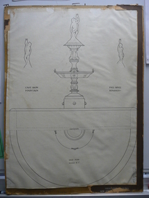
Artwork,other - NORMAN PENROSE COLLECTION: CAST IRON FOUNTAIN
Artwork. Norman Penrose collection: pen and ink drawing of cast iron fountain, Pall Mall, Bendigo. Also 1/2 plan, scale 1-1/2 inches = 1 foot. Part of brown matt remaining. Signed N. Penrose. Bendigo. Measured Drawing for A (rest is missing).N. Penrosedrawing, ink, norman penrose collection, artwork, cast iron fountain, pall mall, bendigo -
 Bacchus Marsh & District Historical Society
Map, Lerderderg District Proposed Irrigation and Water Supply Trust (A). Plan showing boundaries of Trust District
The 1886 Irrigation Act in Victoria introduced the first legislation in Australia designed to enable the creation of a detailed scheme for agricultural irrigation. Part of the legislation saw the use of government funds for local irrigation projects. These local projects were managed by local irrigation trusts. The Lerderderg Irrigation and Water Supply Trust] was formed in 1890. This map depicts the proposed area of the Trust.Printed paper map of the proposed Lerderderg District Irrigation and Water Supply. Plan showing boundaries of Trust District. The Lerderderg District lies within the Parishes of Korkuperrumul and Merrimu in the County of Bourke. At the top of the map above its title is the letter 'A; in capital lettering. Scale: 40 Chains = 1 inch.irrigation, water supply, lerderderg irrigation and water supply trust -
 Bacchus Marsh & District Historical Society
Map, Limestone Reserve Parish of Merrimu 1888
Limestone deposits in the Coimadai area 10 kilometers north of Ballarat were first worked in the 1850s. The area was quarried for limestone for many years by various people and companies. The surveyor's name who produced this plan is inscribed on the map and below this is the name P. L. Alkemade, who presumably paid for the map to be produced. In 1886 Petrus Alkemade in partnership with Matthew Egan established the Alkemade Hydraulic Lime and Cement Company. The Alkemade family were involved in the limestone industry over several generations at Coimadai.Single page map showing part of the Limestone reserve near Coimadai in the Parish of Merrimu. Scale 4 chains to 1 inch. Part of a set of maps which are pasted into a bound volume containing 76 maps or plans in total. High resolution digital image stored on BMDHS computer network. Copy of plan surveyed by Mr. G? [illegible] an authorised surveyor on 17th July 1888. P. L. Alkemadebacchus marsh victoria maps, lime kilns coimadai, limestone, coimadai victoria maps, alkemade family coimadai