Showing 123806 items matching "main-road"
-
 Kew Historical Society Inc
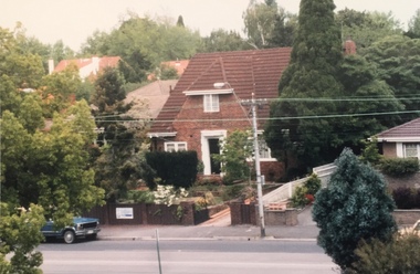
Photograph - 306 Cotham Road, 1988
Colour photographic positive of 306 Cotham Road, Kew. 306 cotham road -- kew (vic.) -
 Federation University Art Collection
Oil on board, 'Bush Track' by Neville Bunning
This item is part of the Federation University Art Collection. The Art Collection features over 1000 works and was listed as a 'Ballarat Treasure' in 2007.Small scene depicting horse and cart on country road. Signed bottom right Neville M Bunning.art, artwork, framing required, neville bunning, horse -
 Port Fairy Historical Society Museum and Archives
Photograph, Jock Varcoe
South Beach DevelopmentColoured photograph of Road building on South Beach Estatesouth beach, development, road, street, building -
University of Melbourne, Burnley Campus Archives
Photograph - Black and white print, 946/11, 30 March 1948
"30/3/48." Road from Swan Street. road, swan street, e. m. gibson collection -
 Melton City Libraries
Photograph, "Green Hills" Borbidge, 1978
Built by Water Browne c.1903 Greenhills was one of the first pastoral runs, and centres of European settlement, established in the Shire of Melton. Estate in Diggers Rest Coimadai Road, Toolern Valelocal architecture, pioneer families -
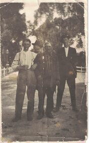 Linton and District Historical Society Inc
Photograph, Bill Murrell, Tom Jones, Dave Reidy and Steve Chasey
Black and white image of four men standing on a road.bill murrell, tom jones, dave reidy, steve chasey -
 Whitehorse Historical Society Inc.
Photograph - Black and white photograph, Buildings made from Blackburn Brick
Used by donor in 'Blackburn - a picturesque history'Original bakehouse at rear of 97 Railway Road Blackburnblackburn brick and tile co, blackburn -
Canterbury History Group
Photograph - Street view of shop at No. 107 Maling Road, Jan Pigot, 27/03/1993 12:00:00 AM
Coloured photograph of Tim's Bookshop at No. 107 Maling Roadcanterbury, maling road, shops -
Canterbury History Group
Photograph - Shop at No. 107 Maling Road, Jan Pigot, 27/03/1993 12:00:00 AM
Coloured photograph of Tim's Bookshop at No. 107 Maling Roadcanterbury, maling road, shops -
Canterbury History Group
Photograph - Shop at No. 103 maling Road, Jan Pigot, 27/03/1993 12:00:00 AM
Coloured photograph of Time for Tea at No. 103 Maling Roadcanterbury, maling road, shops -
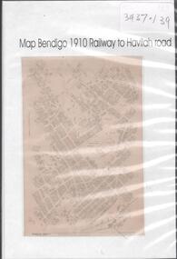 Bendigo Historical Society Inc.
Map - MAP BENDIGO, 1910
DVD. Map of Bendigo 1910 Railway to Havilah Road. -
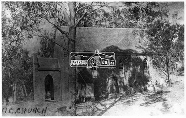 Eltham District Historical Society Inc
Negative - Photograph, Eltham - Old R.C. Church (building not there in 1923)
Eltham - Old R.C. Church (building not there in 1923). The original St Mary’s Roman Catholic Church (1865-1912) was built of clay brick with buttress walls and a slate roof on the corner of Fordhams Road and Maria Street (Main Road), Eltham South, opposite the present-day Wingrove Park. It was blessed on September 3, 1865. With the arrival of the railway in 1901 and the town centre moving closer to the station, the decision was made to relocate the site of the church to its present-day location on Henry Street at the corner of Main Road. A new timber weatherboard church, also called St Mary's was erected and blessed on October 13, 1912. The church and land cost £1,400 (Evelyn Observer). The original brick church It was demolished in the 1920s and the bricks and windows were recycled to build a dairy on the Brinkkotter farm at Research. The timber church was destroyed by fire in 1961 and a new modern architectural (1960s) style church was erected in its place and named Our Lady of Help Christians Church.This photo forms part of a collection of photographs gathered by the Shire of Eltham for their centenary project book,"Pioneers and Painters: 100 years of the Shire of Eltham" by Alan Marshall (1971). The collection of over 500 images is held in partnership between Eltham District Historical Society and Yarra Plenty Regional Library (Eltham Library) and is now formally known as the 'The Shire of Eltham Pioneers Photograph Collection.' It is significant in being the first community sourced collection representing the places and people of the Shire's first one hundred years.Digital image 4 x 5 inch B&W Negsepp, shire of eltham pioneers photograph collection, eltham, roman catholic church, catholic church, church, main road, st marys catholic church -
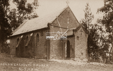 Eltham District Historical Society Inc
Negative - Photograph, St Mary's Roman Catholic Church, Eltham, c.1910
Note the extensive cracking of the mortar and bricks in the front facade near the portico entrance. The original St Mary’s Roman Catholic Church (1865-1912) was built of clay brick with buttress walls and a slate roof on the corner of Fordhams Road and Maria Street (Main Road), Eltham South, opposite the present-day Wingrove Park. It was blessed on September 3, 1865. With the arrival of the railway in 1901 and the town centre moving closer to the station, the decision was made to relocate the site of the church to its present-day location on Henry Street at the corner of Main Road. A new timber weatherboard church, also called St Mary's was erected and blessed on October 13, 1912. The church and land cost £1,400 (Evelyn Observer). The original brick church It was demolished in the 1920s and the bricks and windows were recycled to build a dairy on the Brinkkotter farm at Research. The timber church was destroyed by fire in 1961 and a new modern architectural (1960s) style church was erected in its place and named Our Lady of Help Christians Church.This photo forms part of a collection of photographs gathered by the Shire of Eltham for their centenary project book,"Pioneers and Painters: 100 years of the Shire of Eltham" by Alan Marshall (1971). The collection of over 500 images is held in partnership between Eltham District Historical Society and Yarra Plenty Regional Library (Eltham Library) and is now formally known as the 'The Shire of Eltham Pioneers Photograph Collection.' It is significant in being the first community sourced collection representing the places and people of the Shire's first one hundred years.Digital image 4 x 5 inch B&W Neg Sepia postcardsepp, shire of eltham pioneers photograph collection, eltham, roman catholic church, church, catholic church, main road, st marys catholic church -
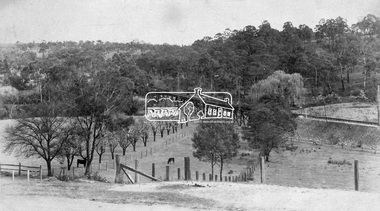 Eltham District Historical Society Inc
Negative - Photograph, Rose Stereograph Company, View at Eltham, Vic, c.1920
View at Eltham, Vic. Looking from Main Road near Henry Street towards Montmorency showing the railway trestle bridge. Henry Street road reserve on west side of Main road in foreground. c.1920 Copy of Rose Series Postcard P. 4348. (The Rose Stereograph Company) George Rose founded the Rose Stereograph Company in 1880 and was joined by Herbert (Bert) Cutts in the early 20th Century. The pair formed a lifetime working partnership and strong personal friendship. Assisted by George’s two sons, Herbert George and Walter, and later by Neil Cutts, the Rose Stereograph Company continued its operations for more than 140 years. The company was initially built on stereographs, but as cinema took over and stereographs fell out of fashion, the Rose Stereograph Company developed Australia’s first commercially viable photographic postcard business. Specialising in postcards of iconic historical moments and significant landmarks, The Rose Stereograph Company became a staple of the Australian travel industry. This photo forms part of a collection of photographs gathered by the Shire of Eltham for their centenary project book,"Pioneers and Painters: 100 years of the Shire of Eltham" by Alan Marshall (1971). The collection of over 500 images is held in partnership between Eltham District Historical Society and Yarra Plenty Regional Library (Eltham Library) and is now formally known as 'The Shire of Eltham Pioneers Photograph Collection.' It is significant in being the first community sourced collection representing the places and people of the Shire's first one hundred years.Digital image 4 x 5 inch B&W Negbridge street, eltham, eltham railway trestle bridge, postcard, rose stereograph company, shire of eltham pioneers photograph collection, trestle bridge -
 Eltham District Historical Society Inc
Photograph - Aerial Photograph, Landata, Lower Plenty, Feb. 1956
Centred on present day 217 Old Eltham Road, Lower Plenty bounded by Pitt Street to north, Yarra River to south, Main Road to east and Bonds Road to west. Historic Aerial Imagery Source: Landata.vic.gov.au Aerial Photo Details: Project No :250 Project : MELBOURNE OUTER SUBURBS PROJECT Run : 17 Frame : 116 Date : 02/1956 Film Type : B/W Camera : EAG9 Flying Height : 10000 Scale : 12000 Film Number : 1176 GDA2020 : 37°43'58"S, 145°07'49"E MGA2020 : 335237, 5822186 (55) Melways : 21 E10 (ed. 42)aerial photo, 1956-02, neil webster collection, eltham, main road, bonds road, elham, lower plenty, melway 21e10, pitt street, yarra river -
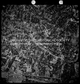
 Eltham District Historical Society Inc
Photograph - Aerial Photograph, Landata, Eltham, Vic, Apr. 1972
Centred on present day Main Road at Pryor Street, Eltham bounded by Park West Road to north, Napoleon Street to south, Woodridge Estate to east and Ryans Road to west. Historic Aerial Imagery Source: Landata.vic.gov.au Aerial Photo Details: Project No :985 Project : MELBOURNE 1972 Run : 27 Frame : 47 Date : 04/1972 Film Type : B/W Camera : RC10 Flying Height : 5700 Scale : 9600 Film Number : 2636 GDA2020 : 37°42'45"S, 145°09'12"E MGA2020 : 337223, 5824470 (55) Melways : 22 A4 (ed. 42)aerial photo, neil webster collection, 1972-04, eltham, eltham railway station, woodridge estate, eltham shops, main road, melway 22a4, napoleon street, park west road, pryor street, ryans road -
 Eltham District Historical Society Inc
Photograph - Aerial Photograph, Landata, Montmorency / Lower Plenty, 28 Jan. 1946
Centred on 32 Grand Boulevard, Montmorency bounded by Rattray Road to north, Main Road, Lower Plenty to south, Bolton Street to east and Looker Road to west. Historic Aerial Imagery Source: Landata.vic.gov.au Aerial Photo Details: Project No :5 Project : MELBOURNE AND METROPOLITAN AREA PROJECT Run : 34 Frame : 61778 Date : 12/1945 (28.1.46) Film Type : B/W Camera : EAG4 Flying Height : 10200 Scale : 6000 Film Number : 212 GDA2020 : 37°43'30"S, 145°07'37"E MGA2020 : 334934, 5823043 (55) Melways : 21 E8 (ed. 42)aerial photo, bolton steet, looker road, lower plenty, main road, montmorency, phoebe mason collection, rattray road -
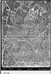
 Eltham District Historical Society Inc
Photograph - Aerial Photograph, Landata, Montmorency / Lower Plenty, Nov. 1975
Centred on 328 Main Road, Lower Plenty bounded by Rattray Road, Montmorency to north, Rosehill Road to south, Falkiner Street to east and Lower Plenty shops to west. Historic Aerial Imagery Source: Landata.vic.gov.au Aerial Photo Details: Project No :1243 Project : (ALSO A.P. 1227) Run : 24A Frame : 146 Date : 11/1975 Film Type : B/W Camera : RC8 Flying Height : 5000 Scale : 10000 Film Number : 2722 GDA2020 : 37°43'40"S, 145°07'32"E MGA2020 : 334820, 5822743 (55) Melways : 21 D8 (ed. 42)aerial photo, lower plenty, main road, montmorency, phoebe mason collection, eltham lower park, falkiner street, lower plenty shops, rattray road, rosehill road -
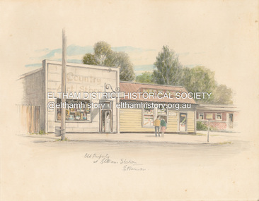 Eltham District Historical Society Inc
Artwork, other - Sketch, E. Foreman, Old property at Eltham Station, c.1980
Situated at 965 Main Road adjacent to the Eltham Railway Station, the Country Art Store was originally a hairdresser and Tattersalls agency In 1968 Pam Robinson and Caroline Shenton opened a small shop on the corner of Main Road and Napoleon Street. Four months later a damaged fire hyrdant flooded the store and ruined all their stock. The pair moved to the former hardresser shop at 965 Main Road, adjacent to the Eltham Railway Station, opposite the Stationmaster's house and opened the Country Art Store and adjacent gallery. At the time the only other shop selling pottery was the Potters Cottage in Warrandyte. During the 1970s the gallery was the Wiregrass Gallery. In 1993, after 25 years operating the Country Art Store, the pair decided to sell up and move to warmer climates. During the course of their business a number of craft shops and galleries opened and closed in Eltham. One such shop was Bimbadeen, next to Ansell and Muir's chicken shop opposite Eltham Lower Park. That business run by Don Brown, then a local artist was taken over as River Clay run by Leo Haanappel and Coeny Dommers but ultimately sat in a flood plain and was demolished. When the Country Art Store became available in 1993, Leo Haanappel and Coeny Dommers took it over. The premises became Platform 3095 cafe around 2015.Old Property at Eltha Station E. Foremanart store, country art store, country art store (eltham), eltham railway station, platform 3095, restaurants, shops, wiregrass gallery -
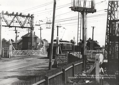 Melbourne Tram Museum
Photograph - NMETL tram 4 Epsom Road level crossing, Victorian Railways, c1919
Photo of the Level Crossing in Epsom Road, Flemington or Ascot Vale showing the overhead arrangement and structures either side of the road to provide power to either the trams or the trains. The small signal box is in the view as well as the interlocked gates. A NMETL saloon tram, No. 4, is crossing the railway lines. Photo late 1919 or 1920. Has the words "VR Tramway Crossing at Epsom Rd showing insulators in tram line and special crossing fitting." The level crossing was electrified on 18-8-1919 and abolished mid 1925 when the underpass was built. See Weekly Notice Extracts 1894-1994, published 1996. See item 8667 for a similar photo with tram 184.Yields information about the Epsom Road level crossing and tram 4.Photograph, Black and White, with notes on the rear.In ink on the rear: "Melbourne - North Melbourne Electric Tramway and Lighting Co. Ltd - No. 4 in Epsom Road on level crossing to Showrooms and Flemington Racecourse. About 1919-1920." Has KSK stamp and Number LWR-4 and CEE 12 in to right-hand corner.trams, tramways, level crossings, nmetl, epsom rd, showgrounds, ascot vale, tram 4 -
 Bendigo Historical Society Inc.
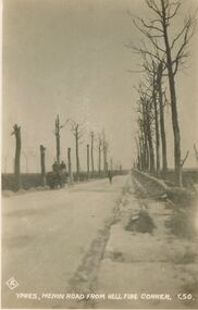
Postcard - ACC LOCK COLLECTION: YPRES, MENIN ROAD FROM HELL FIRE CORNER, POSTCARD, 1914-1918
Postcard, WW1, B&W image of the Menin Road from Hell Fire corner, Ypres. Burnt out trees on both sides of the road. A horse and cart with two men on cart coming towards the viewer. Lone figure on road in middle distance. One copy Y50postcard, postcard, ww1, france, ypres, menin road, hell fire corner. -
 Ballarat Tramway Museum
Photograph - Black & White Photograph/s, John Phillips, 1980
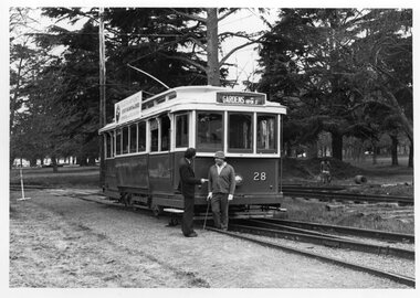
Black and White photograph of Gavin Young and Carry Davey in front of No. 28 on No. 2 road at the BTPS depot 1980. Photo used in the 1979 - 1980 Annual Report. Photo by John Phillips. Note the construction of No. 40 road in the background and the remains of No. 3 road extension or the ski jump. On the rear of the photo "BC Bottom", "Gavin Young chats to Driver Gary Davey in front of No. 28, resplendent in its 1950's colour scheme." (G) S/S all in pencil.tramways, trams, btps, depot, track construction, tram 27 -
 Mt Dandenong & District Historical Society Inc.
Photograph
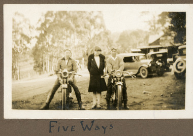
The men on the motorbikes have goggles on their heads but no helmets. They are parked at the Five Ways intersection at Kalorama. The building behind them is the FiveWays Cafe. The image is from the album of Ivy Child and would be late 1920s. Ivy May Child (1910 – 1989) was the daughter of Arthur Edward (Ted) Child (1878 – 1964) and Ethel May Madden (1888 – 1970). Ted Child was the son of Matthew Francis Child (1839 – 1933) and Martha Jeeves (1857 – 1926). He was the grandson of one of the early pioneers Francis Child. Ivy grew up on the family property on Childs Road and took many photographs. Most of these are glued into her photo album. The album covered the years from c1927 – 1932. Ivy married Henry William Burgess (1906 – 1968) in 1944. The photographs remain in their original state in the album with individual copies made. Sepia coloured photograph showing two men on motorcycles parked with a woman standing between them. Three old cars, a building, road and trees are visible behind them.Written below photograph in album: FIVE WAYSmotorcycle, motorbike, fiveways, five ways, fiveways cafe -
 Ballarat Tramway Museum
Slide - 35mm slide/s - set of 14, Noel Simons, 22/05/1971 12:00:00 AM
Set of 14 transparencies taken on 22/5/1971. 1170.1 - No. 31 outbound in Sturt St. West near Murray St. - has "To read pack Tilt Train" roof advert. 1170.2 - No. 31 ditto, near Russel St. loop. 1170.3 - No. 14 in Wendouree Parade at what is now BTM Depot Junction, near Toilet block. 1170.4 - No. 31 in Wendouree Parade at the North Gardens, approaching St. Aidans Drive 1170.5 - Scrubber car on "O " road with tennis court alongside. 1170.6 - Scrubber, 43 and 3 8 on 0 road at depot. 1170.7 - 3 8 and 43 on 0 road at depot 1170.8 - 38 on 0 road at depot, showing sharpness of 0 road curves. 1170.9 - 39 and 40 inside depot. 40 has "To read pack, tilt tram" roof advertisement. 1170. 10 - Tram 27 passes the depot gates, east bound with Lake Wendouree in the background. 1170.11 - SEC Depot, from Wendouree Parade, with No. 38 on "O" road. 1170.12 - trams 14 and 30 at depot loop, Wendouree Parade 1170.13 - ditto 1170.14 - "Cars take following line" sign on tram stop pole at Wendouree Parade Loop. All have date stamp of "28 Apr 1971" in purple ink on base. All blue ink unless otherwise noted. 1170.1 - "No. 31 in Sturt St. West between Murray and Wonliss Sts." 1170.2 - "No. 31 approaching Russell St. Loop in Sturt St. West Ballarat" 1170.3 - "No. 14 Gardens" 1170.4 - "No. 3 1 North Gardens 1170.5 - "Track cleaner car (formerly No. 23) at Wendouree Depot" 1170.6 - "Track cleaner, No. 43 and No. 38 at Wendouree Depot" 1170.7 - "No. 43 and No. 38 at Wendouree Depot" 1170.8 - "No. 38 gazes across Lake Wendouree from depot" 1170.9 - "Nos 3 9 and 40 in Wendouree Depot" 1170.10 - "No. 27 passing Wendouree Depot" 1170.11 - "Wendouree Depot with No. 38 on road No. "O" on left. 1170.12 - "Depot Loop" 1170.13 - "Depot Loop" 1170.14 - "Depot" tramways, trams, sturt st. west, wendouree parade, o road, depot, depot loop, signs, bliss bombs, tram 14, tram 27, tram 30, tram 31, tram 38, tram 39, tram 40, tram 43, tram scrubber -
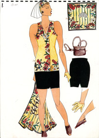 National Wool Museum
Work on paper - Women's Opening/Closing Ceremony Uniform Design Drawings, Wendy Powitt, c. 1992
A set of laminated A3 sketchbook pages depicting designs for the 1992 Barcelona Olympic Women's Opening/Closing Ceremony Uniform designed by Wendy Powitt. On the 1992 Barcelona Olympic Games donor Doug Pleasance wrote- The 1992 Barcelona Olympic Games saw an evolutionary change in designer selection. A Declaration of Interest Form was communicated to over forty potential designers. The task and especially tight timelines that were involved deterred many aspirants, however, there remained eight designers with the potential we were seeking. These eight designers were paid $3,000 per submission and the winning designer, Wendy Powitt, was paid $15,000. For the first time the judging panel included two athletes, one male swimmer and one female basketballer, their influence was pivotal. Opening Ceremony Uniform included a lightweight wool fabric printed with floral designs that had been inspired by the work of Australian artist Margaret Preston. This included: Lightweight W/PE shorts by Fletcher Jones in Foster Valley Fabric, socks by Holeproof and footwear by Hush Puppy.8120.1 - A laminated A3 sketchbook page depicting a design for the 1992 Barcelona Olympic Women's Opening/Closing Ceremony Uniform. The main drawing shows the design for a dark green skirt, a yellow printed sleeveless button up shirt, a matching headband and scarf, yellow gloves and brown leather shoes. To the right of the main image are five detail drawings of the skirt, gloves, shoes and scarf as well as a depiction of a brown leather bag. 8120.2 - unnumbered- mounted on green card this sketchbook page depicts a design for the 1992 Barcelona Olympic Women's Opening/Closing Ceremony Uniform. The main drawing shows the design for a dark green skirt, a yellow printed sleeveless button up shirt and yellow gloves. 8120.3 - unnumbered- A laminated A3 sketchbook page depicting a design for the 1992 Barcelona Olympic Women's Opening/Closing Ceremony Uniform. The main drawing shows the design for a dark green skirt, a yellow printed sleeveless button up shirt, a matching headband and scarf, yellow gloves and brown leather shoes. To the right of the main image are five detail drawings of the skirt, gloves, shoes and scarf as well as a depiction of a brown leather bag.1992 barcelona olympics, sport, athletes, fashion, design, artwork, drawing, uniform -
 Whitehorse Historical Society Inc.
Photograph, Our Lady of Fatima Parade, C.1950's
Black and white photo of Our Lady of Fatima Parade passing through Mitcham Shopping Centre, Whitehorse Road, Mitcham, on its way to Whitefriars Monastery, Park Road, Park Orchards C.1950's.H.S. Beckwith Authorised Newsagent (located at far right of photo) is number 503 Whitehorse Road, Mitcham. Note Mitcham Primary School (Junior School) at rear of Whitehorse Road shops.our lady of fatima parade -
City of Kingston
Photograph - Black and white, 5 January 1984
Cheltenham and Heatherton are suburbs in the City of Kingston that were originally established as a rural market gardening community. The market gardens, farms and paddocks have gradually been sub-divided into housing and industrial estates and associated infrastructure such as schools and shopping facilities. This aerial image covers a diverse section of the City of Kingston, taking in the suburbs of Cheltenham, Heatherton, Mentone and Parkdale. By 1984, the market gardens of the district have been replaced by housing and factories. The Nylex factory is visible and now closed. Mentone Bowl on the corner of Warrigal Road and Nepean Highway has now been replaced by high rise apartments, another feature of the changing landscape in the City of Kingston. The vacant land now occupied by the Moorabbin Airport Direct factory Outlet (DFO) is also depicted.Aerial photograph of Cheltenham, Heatherton, Mentone and Parkdale within the City of Kingston. The area depicted in the 1984 aerial view includes Centre Dandenong Road and Cheltenham East Primary School (top left), Kingston Heath Reserve (top right), intersection of Lower Dandenong Road, Warrigal Road, Balcombe Road and Nepean Highway (bottom left), Balmoral Drive/McSwain Street Parkdale (bottom right).White text: 3831-179 Lens information [indecipherable] RINGWOOD M/S 7922-3 RUN 16 [Clockface image] 5,300' ASL VIC DLS© 5-1-84cheltenham, heatherton, mentone, parkdale, market gardens, urbanisation -
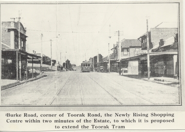 Melbourne Tram Museum
Photograph - Black & White Photograph/s, 1970's
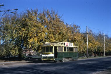
Black and white copy photograph from a Real Estate Poster of a tram in Burke Road, Camberwell, at corner of Toorak Road. Has title on photograph "Burke Road, corner of Toorak Road, the Newly Rising Shopping Centre within two minutes of the Estate, to which it is proposed to extend the Toorak Tram" Street lighting suspended off the tramway overhead. Tram is a single trucker in the PMTT numbering livery.trams, tramways, mmtb, pmtt, burke rd, toorak rd -
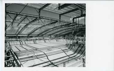 Ringwood and District Historical Society
Photograph, Ringwood Council- Aquatic Centre
Black and white photograph"Written on back of photograph" Ringwood Aquatic Centre View of main pool and roof - Diving pool in immediate foreground. 1985 -
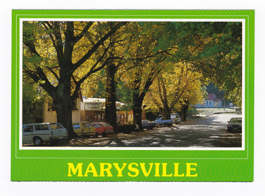 Marysville & District Historical Society
Postcard (Item) - Colour postcard, Scancolor (Australia) Pty Ltd, MARYSVILLE Victoria-Australia, Unknown
A colour photograph of trees in Autumn lining Murchison Street in Marysville in Victoria.A colour photograph of trees in Autumn lining Murchison Street in Marysville in Victoria. This postcard was produced by Scancolor Australia as a souvenir of Marysville.MARYSVILLE/ Victoria-Australia Spectacular autumn colours of the main street. CS 4065 scancolor Australia (03) 955 1944marysville, victoria, murchison street, autumn, scancolor australia, postcard, souvenir