Showing 3069 items matching "scales"
-
 University of Melbourne, Burnley Campus Archives
Plan, Alton-Hascombe Feature Survey, c. 1990
1 tracing paper and 2 paper copies of plan by Department of Conservation, Forests and Lands, Division of Survey and Mapping, of adjoining gardens Alton and Hascombe at Mount Macedon, Victoria. Scale 1:1000. Plan of properties includes buildings, gardens and paddocks. 1 copy has significant buildings coloured.feature survey, mount macedon, gardens, alton, hascombe -
 Eltham District Historical Society Inc
Scrapbook Album, Scrapbook of clippings relating to members of Eltham District Horse and Pony Club, 1970s
Album contains 11 leaves with horse-and-pony-club-related news items including several loose clippings with hand-written names throughout. Compiled by Lilas Scale, member of the Eltham Pony Club, covering 1972-1977 general information about Pony Club events with some Eltham people. Names noted are Denis Heather, Bill Barrow, Sue Wood, Neil Clinton, Dianne Bennett, Denise Cornall, Sue Pike, Sue Scale, Kirsten Wood, Simon Brau, Sarah Bray, Janine Simpson, Maryka Biesbroek, Fiona Rogers, Mathew Ellis.Magnetic Photo Album with red covers containing 11 leaves with clippings from horsy magazinesbill barrow, denis heather, denise cornall, dianne bennett, eltham horse and pony club, eltham pony club, fiona rogers, janine simpson, kirsten wood, lilas scale, maryka biesbroek, mathew ellis, neil clinton, sarah bray, simon brau, sue pike, sue scale, sue wood -
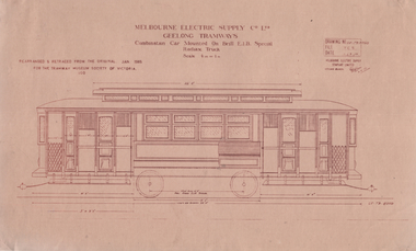 Ballarat Tramway Museum
Drawing, TMSV, "Combination Car Mounted Brill E1B Special Radiax Truck", 1/1985
Drawing of Melbourne Electric Supply Co. Ltd (MESCo) Geelong tramways - "Combination Car Mounted Brill E1B Special Radiax Truck" - trams 16 to 23, built by Pengelley & Co in Adelaide 1924-25. Details the tramcar elevation with dimensions, and shows the towbars. Drawing dated Jan 1985, prepared for the TMSV. Scale 1/4"=1' Second drawing is titled "Elevations of body Pengelley tram Nos. 20-23" - based on MESCo drawing GE-T9-8358. Drawing dated Jan 1985, prepared for the TMSV. Scale 1/4"=1' Yields information about the Pengelley built tramcars for Geelong.Set of Drawings printed on light brown paper with brown ink - Drawing GE-T9-8350 and GE-T9-8358trams, tramways, geelong, drawings, pengelley -
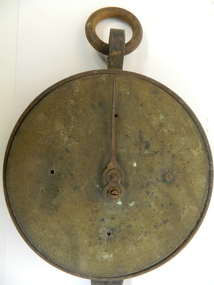 Kiewa Valley Historical Society
Tobacco Scales, Early 1900's
Tobacco farming began circa 1960 in the Kiewa Valley and consequently became one of its major industries. Many of the italian families were involved in tobacco farming. These scales were bought from Arthur Barnard in 1962.Historical: Tobacco farming began circa 1960 in the Kiewa Valley and consequently became one of its major industries. Many of the Italian families were involved in tobacco farming. Provenance: This tobacco farmer came from Italy and was sponsored to visit a tobacco farmer in Myrtleford to learn how to grow tobacco so that he could transfer those skills to his own farm in the Kiewa Valley.Iron circular plate attached to iron frame with rings attached to rings at both ends. 1 end facing frontwards and second end facing sideways. At 1 end is a back to front iron S formed as a hook. Attached to the middle of the plate is a very thin and sharp pointer. The plate is attached to a rectangular iron solid rectangle. Used to weigh leaf when bailing.0 - 250 numbers (by 10s) and measurements faintly inscribed around the edge of the plate.tobacco. kiewa valley. mongans bridge. arthur barnard. scales. rossaro. -
 Greensborough Historical Society
Map - Map (Copy), C. Hodgkinson, District Surveyor et al, Parish of Yan Yean 1856: Village site during construction of the Yan Yean Reservoir, 1978
Copy of map part Sec. 13, Parish of Yan Yean 1856, Map 3, Village site... Scale: 8 chains to 1 inch. Drawn by C. Hodgkinson, District Surveyor, redrawn by A. R. Blair 1978. 1 p. photocopy of map. yan yean reservoir, yan yean -
Frankston RSL Sub Branch
Map, SECRET LANDING GROUNDS AUSTRALIA
Large map of aircraft landing grounds located in Australia and some nearby Islands. This map shows landing grounds in use during the latter years of World War 2. The map is in Mercator Projection to the Equatorial Scale 1:4,000,000. The scale is statute miles. Each landing ground location is shown by a symbol indicating category and name. The legend explains the landing ground categories: RAAF Main Landing Grounds, RAAF Emergency Landing Grounds, Seaplane Anchorages, Civil Main Landing Grounds, Civil Emergency Landing Grounds and Cancelled Landing Grounds. The map was revised 4th September, 1945. The map is printed on paper which is attached to a linen backing, The map is quite faded and in a fragile condition. -
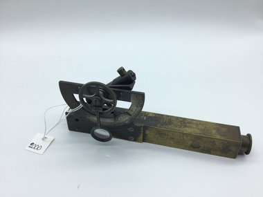 Myrtleford and District Historical Society
Inclinometer, Early 20th Century
Provenance not clear. Leather case has 'MMBW' inscribed in black pen, indicating an association with Melbourne Metropolitan Board of Works. Item has been in the possession of Terry McCormack since 1972Hand held brass pocket inclonometer level, circa 1920. Leather case for safe storage. Semi circular graduated dial with 90 degree vernier scale with a small (20mm) magnifying glass to aid reading the vernier scale. Above the body, mounted at the rear of the graduated dial, is a spirit level tube which is tilted by finger movement to the milled hand wheel. The height to be determined is sighted through the instrument eyepiece and the bubble tube is tilted until the bubble, viewed in the mirror inside the sighting tube, is brought level with the graticule sighted at the top of the subject object. An angle is thus obtained and by measuring the distance on the ground to the object, trigonometry can be applied to determine the height of the object.Herga & Co. BRISBANE. Made in England -
 Kiewa Valley Historical Society
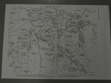
Maps - Squatting Runs of the Murray District 1848 x2, July 26,1848
The Port Phillip Gazette was the second newspaper published in Melbourne, in the then Port Phillip district, now Victoria. In 1948 it was published bi-weekly.The map shows the original names of squatters along the Kiewa River. The names of the district are mostly current today although some are spelt differently.2 copies - 1 laminated & 1 paper of the map of "Squatting Runs of the Murray District 1848." The area is recorded (eg. Tawanga, Dederang, Gundowring, Kergunia, Merrimarenbung all along the Kiewa River) under which the names of the squatter is recorded, the number of acres and the licence number. Scale is 8 miles to the inch.squatting runs; kiewa valley; port phillip district; -
 Bendigo Military Museum
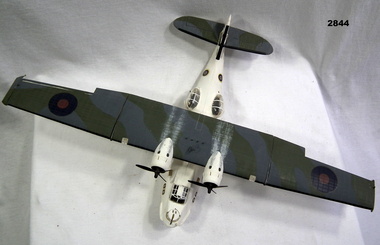
Leisure object - MODEL, FLYING BOAT, post WW2
Plastic scale model of Catalina Flying Boat. Twin engines on high main wing. Camouflage colouring on top of wing & tail wings. White fuselage & under wings. Gun mounted in front of cockpit. Two Rockets under each side of main wing. Gun turrets on each side of fuselage.Each side of fuselage under cockpit: "No 88" Each side of tail fin: "No 1188"military history - souvenirs - air force, passchendaele barracks trust -
 Bendigo Military Museum
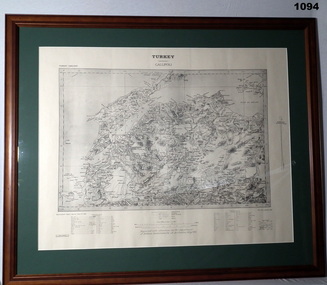
Map - MAP GALLIPOLI, FRAMED
Brown, wooden frame with glass front, white cardboard backing, map mounted with green border. Map of Gallipoli area in black & light grey with white border. A detailed map of Turkey area around Dardanelles with references & scale charts at bottom. Reprinted for the Department of Defence, Commonwealth of Australia, May 1915.Front Top Centre: Turkey, Gallipoli. Rear: Bethany Gallery stamp.documents - maps, military history, gallipoli -
 Federation University Historical Collection
Plan, Haddon, County of Grenville, 1932, 13/04/1932
The Haddon Parish Plan shows crown parcels government roads, Crown Reserves, Railway. Scale 40 chains to 1" (1:31, 680) WGS 84 Centroid Lat: 37 degrees 34' 00" S Long: 148 degrees 40' 20" E N.S. 9.3km E.W.: 16.1kmhaddon, grenville, cardigan, water supply reserve, nentingbook pre-emptive right, a. mclachlan, lake burrumbeet, e.a. wynne, p. russell, b. hepburn, benjamin hepburn, nentingbool, t.c. wilson, j. amoy, william collard smith, james roach, j. mitchell -
 Bendigo Historical Society Inc.
Map - STATE RIVERS AND WATER COMMISSION : COLIBAN DISTRICT IRRIGATION AND TOWN SUPPLY CHANNELS, 30/11/1956
State Rivers and Water Supply Commission. Foolscap-size map. Title : Coliban district Plan showing Irrigation and Town Supply Channels. The map covers the area from Raywood to Guildford. Scale : 1 inch to 4 miles. Dated 30/11/56, number 5,491 in bottom right corner.state infrastructure, water supply, coliban system, state rivers and water supply commission. coliban system. -
Bendigo Historical Society Inc.
Map - CAMPBELL COLLECTION: BENDIGO AND DISTRICT MAPS, 8-6 29
Map. Kimbolton, Parishes of Kimbolton and Lyell, scale 20 chains to 1 inch. Area by Plamimeter 6258 acres. Coliban River, Knowsley, Strathfieldsaye 10 1/2 miles. Prepared in W.P.B. from Parish and Assessor's Plans. G.W.Latimer 8-6-29. (number 393 in map cupboard 1)G.W.Latimermap, bendigo, allotments -
Bendigo Historical Society Inc.
Map - CAMPBELL COLLECTION: BENDIGO AND DISTRICT MAPS, 16-4-29
Map. Kennington, Parishes of Sandhurst, Mandurang and Strathfieldsaye. Scale 20 chains to 1 inch. Total area 2918 acres. Bendigo 2 1/2 miles. Prepared in W.B. from A.and C. L. Plans by W.J. Galbraith, 16-4-29. (number 364 in map cupboard 1)W.J.Galbraithmap, bendigo, allotments -
Bendigo Historical Society Inc.
Map - CAMPBELL COLLECTION: BENDIGO AND DISTRICT MAPS, March 1947
Map. Mandurang, County of Bendigo, Sandhurst, Strathfieldsaye, Sedgwick, Sutton Grange, Ravenswood, Lockwood. Scale 40 chains to 1 inch. Drawn and reproduced at the Department of Lands and Survey, Melbourne, March 1947, price 2/-. By Authority : J.J. Gourley, Government Printer, Melbourne. (number 402 in map cupboard 1)J.J. Gourley, Government Printer.map, bendigo, allotments -
Bendigo Historical Society Inc.
Map - CAMPBELL COLLECTION: BENDIGO AND DISTRICT MAPS, August 1952
Map. Nerring, County of Bendigo, Yarraberb, Neilborough, Leichardt, Marong, Sandhurst, Huntly. Scale 20 chains to 1 inch. Drawn and reproduced at the Department of Lands and Survey, Melbourne, Victoria, August 1952. Price 2/-. By Authority J.J. Gourley, Government Printer, Melbourne. (number 404 in map cupboard 1)J.J. Gourley, Government Printermap, bendigo, allotments -
Bendigo Historical Society Inc.
Map - CAMPBELL COLLECTION: BENDIGO AND DISTRICT MAPS, 1963
Map. Sedgwick, County of Bendigo. Scale 20 chains to 1 inch. Strathfieldsaye, Eppalock, Lyell, Mandurang, Sutton Grange, County of Talbot. By Authority A.C. Brooks,Government Printer, Melbourne. Drawn and reproduced at the Department of Lands and Survey, Melbourne.1963. Price 2/-. (number 405 in map cupboard 1)A.C. Brooks, Governmenr Printer, Melbourne.map, bendigo, allotments -
 Port Melbourne Historical & Preservation Society
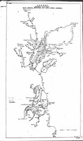
Photograph - Demolition, J Kitchen & Sons perimeter survey, Jul 2014
As the former j Kitchen & Sons site was being cleared, Lionel Layfield, who had worked at the site for many years undertook several pictorial perimeter surveys. These photos were taken July 2014.Series 3 of colour photographs taken by Lionel Layfield again walking around the perimeter of J Kitchen and Sons during demolition (later than series 2) . In particular the photographs show the weighbridge, as it was still functioning for the demolition trucks. Details of the interior refer to the weighbridge scales, security and customs associated functions.industry - manufacturing, built environment - industrial, transport - motor vehicles, j kitchen & sons pty ltd -
Tatura Irrigation & Wartime Camps Museum
Mixed media - DVD, Tatura's Historical Past
A historical look into Tatura's pastCopied Disc is tdk gold in colour. Cover is Black and Grey with white writing. Grey scale photo of Tatura Butter Factory at top, Colour photo of Arnott's Biscuits van at bottom. Back has 4x black & white photos and list of music used. Made by Mishka Media productions in 2012On front Tatura's Historic Past, on back list of music used -
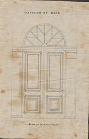 Bendigo Historical Society Inc.
Document - MARKS COLLECTION: DRAWING FOR ELEVATION OF DOOR
Drawn on waxed paper. On top of plan 'Elevation of Door' printed in black ink, on bottom 'Scale an inch to a foot'. Plan shows double doors, arched window above. Contained in items from Fortuna Villa, although not marked as such. On bottom of plan purple ink stamp 'Vahland & Getzschmann, Architects, Sandhurst'.Vahland & Getzschmann, Architects, Sandhurst.bendigo, house, fortuna villa -
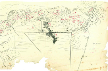 Beechworth Honey Archive
Hand-Drawn Map Centred on Buckland Gap Road by Frank Lebbell Frost July 1916
This is one of the maps drawn by Frank L. Frost while he was beekeeping in North-East Victoria. This particular map may be reference in the "Wooden" Diary on page 8.Hand-drawn map centred on Buckland Gap road (near Murmungee). Details the quantity and quality of flowering timber in the nearby State Forest. Scale is 1/2 mile to 1 inch. Map was drawn on the 16th July, 1916. Drawn with black pen and grey lead on paper. Features are marked in red.hand drawn, hand-drawn, map, buckland gap, frost, beekeeper, beechworth honey -
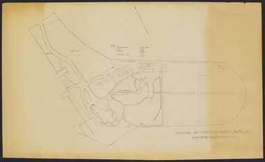 University of Melbourne, Burnley Campus Archives
Plan - Sketch, School of Horticulture - Burnley, 1957
A,B,C,E paper copies, D, tracing paper copy of plan. Hand drawn sketch of central area of grounds. Figures given for acreage of ornamentals, crops and grazing although only 1 acreage is shown on plan. (E) has further annotation. Scale 1 inch:40 ft.burnley gardens, ornmental, crops, grazing, burnley school of horticulture -
University of Melbourne, Burnley Campus Archives
Map, Photo Mapping Services Pty. Ltd, Burnley College Burnley Gardens, 1995
HistoricalMap compiled by Photo Mapping Services Pty. Ltd., using aerial photography, dated 9th July, 1995. (1) Coloured proof. Scale 1:500. Aerial views, with and without trees marked, of Burnley Gardens: (2) Map with trees (3) Map without trees, sections numbered but no legend.burnley college, gardens, trees -
![Map, [Coornmill land area available for leasing for grazing, Parish of Coornmill]. Circa 1904](/media/collectors/5e461d8021ea67224c82f2a1/items/677cde147f2053f3e5d277c3/item-media/677cdeea7f2053f3e5d27bb4/item-fit-380x285.jpg) Bacchus Marsh & District Historical Society
Bacchus Marsh & District Historical SocietyMap, [Coornmill land area available for leasing for grazing, Parish of Coornmill]. Circa 1904
This map shows an area of land north of Bacchus Marsh in the Larderderg State Park area known as the Parish of Coornmill.The map indicates an area of land which was to be made available by public tender for grazing leaseholders. The plan to do this was discussed in the Bacchus Marsh Express newspaper on the 16 July, 1904, page 2, column 7. The area reserved for grazing leases is identified by red lines on the map. The Express described the area available for grazing was 12,000 acres.A single page paper map showing an area of land in the Parish of Corrnmill to be made available for grazing leases. A photo lithographed Lands Department Map. No scale indicated. The map is pasted into a bound volume containing 76 maps or plans in total. High resolution digital image stored on BMDHS computer network. coornmill parish maps, lerderderg state park maps, agriculture bacchus marsh area -
![Map, Plan showing proposed deviation of the road through McKenzie's Flat to Bacchus Marsh. [Undated]](/media/collectors/5e461d8021ea67224c82f2a1/items/677d22f37f2053f3e5d500dc/item-media/677d25247f2053f3e5d50950/item-fit-380x285.jpg) Bacchus Marsh & District Historical Society
Bacchus Marsh & District Historical SocietyMap, Plan showing proposed deviation of the road through McKenzie's Flat to Bacchus Marsh. [Undated]
The date of this map or plan is uncertain. McKenzie's Flat is a bushland picnic area on the Lerderderg River in the Lerderderg State Park close to Bacchus Marsh. The proposed road deviation shown on this map is very close to a sharp bend in the Lerderderg River which shows an island in the centre of that bend. The name of a landholder, J.B. Perry is shown on the map close to the area of the road deviation.The land shown is identified as within the Parish of Merrimu.Single page map showing a proposed deviation of the road from McKenzie's Flat to Bacchus Marsh. Scale: 5 chains to 1 inch. Part of a set of maps which are pasted into a bound volume containing 76 maps or plans in total. High resolution digital image stored on BMDHS computer network. mckenzies flat bacchus marsh, bacchus marsh roads and streets -
 Bacchus Marsh & District Historical Society
Map, Plan of Land at Bacchus Marsh, the Property of James Young, 1868
James Young was a prominent businessman, land owner and public figure in the early colonial period of Bacchus Marsh. In February 1868 he offered for sale through the agent W. Anderson 38 blocks of land which ran from the Lerderderg RIver westwards beyond Gisborne Road in the vicinity of the present day Masons Land. The land for sale was described as, 'unsurpassed Agricultural Land, in the immediate vicinity of Bacchus Marsh, varying in size from 2 to 12 acres each'. The sale notice in the Bacchus Marsh Express of 1st February 1868 page 2, also noted that, ' Plans can be seen at Mr. Young's Border Mills Store, and at the Border Inn'. One of the largest and most important land sales in the early colonial period of Bacchus Marsh.A single page paper map showing 38 blocks of land for sale in 1868 in the vicinity of Masons Lane Bacchus Marsh. Scale 11 chains to 1 inch. The map is pasted into a bound volume containing 76 maps or plans in total. High resolution digital image stored on BMDHS computer network. land sales bacchus marsh, bacchus marsh victoria maps, james young 1816-1871, masons lane bacchus marsh land sales -
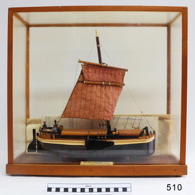 Flagstaff Hill Maritime Museum and Village
Craft - Ship model, 28-01-1985
This unnamed ship model was built by a Warrnambool resident. The Humber Keel design is typical sailing craft used for transport if inshore and inland cargo, from Humber and Hill, around Yorkshire, U.K. in late 19th and early 20th century. Ship model, single mast, double spar, humber keel. Two tone brown and cream paint, light brown sail. Figures of a man, woman and dog on deck. A type of vessel used on the Yorkshire waterways. Perspex case with wooden frame. Folded plans are inside case. Nameplate Plaque inside case describes ship."RIVER HUMBER KEEL/YORKSHIRE/LENGTH 61', BEAM 15'6", DR G CAP 100 TONS/CREW MAN & WIFE, SCALE 1:40/HUON PINE etc. E.H. GRANGER 28.1.1985" on plaque inside caseflagstaff hill, warrnambool, shipwrecked-coast, flagstaff-hill, flagstaff-hill-maritime-museum, maritime-museum, shipwreck-coast, flagstaff-hill-maritime-village, humber keel, sailing cargo -
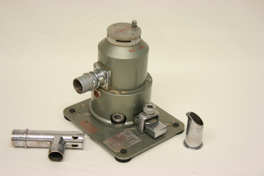 Geoffrey Kaye Museum of Anaesthetic History
Equipment - Tecota trilene inhaler, Cyprane Ltd
The item was donated by Dr K McCaul of the Royal Women's Hospital, Melbourne, in 1966.Anaesthetic trilene was administered to the patient via rubber tubing from the Trilene inhaler, within which the anaesthetic was converted into a vapor. The cylindrical metal apparatus sits atop a flat, square stand with four black rubber feet. Item includes ports and valves for connection to a face mask and vaporising chamber, as well as mask attachment and metal pouring jug with spout.Red markings identifying the manufacturer and the measurement scale are located on both the stand and top twist dial. The base of the mask attachment piece is inscribed with the manufacturer's details: 'Cyprane Ltd'. The metal beaker is engraved with a line marked at the 15cc level. trilene inhaler, tecota, anaesthesia, beaker, mask, vaporise, obstetrics, childbirth, dr k mccaul royal women's hospital melbourne, 1966, vapor, face mask, vaporising chamber, cyprane ltd, keighley -
Clunes Museum
Map, DEPARTMENT OF MINES, Untitled, c1859
All maps show names and locations of mines operating in the district (see reference section link to article).1 Map of Creswick Clunes - lists 45 mines in the Clunes enlargement and 100 mines in the Creswick enlargement .2 Department of Mines map of Clunes Creswick and shows the McDonald & Co. Pre-emptive area. Indexes for quartz and alluvial mine locations .3 Topographical map Ref GF23 Clunes Mt. Greenock Talbot.1 360 Scale 1:2500 .2 303/59 33 hand written in ink "received 15 October 1859" signed by R Broughton, James Stevenson - District Mining Surveyor .3 40 chains to an Inchgold mining, dept of mines -
 Ballan Shire Historical Society
Map - Map. Kerrit Bareet, Department of Lands and Survey, Kerrit Bareet. County of Grant, 08/1944
A map of the Kerrit Bareet area within the County of Grant showing properties and names of owners in 1944.Significant to people researching land usage and ownership. Also those researching families in the area at that time.A map of Kerrit Bareet in the County of Grant. Black printing on buff coloured paper. Details roads, rivers, railways, property boundaries and names of property owners and towns and villages. The map is easily readable although there is some physical damage and that and the borders have been reinforced with sellotape. Shows a Scale in Chains and Price 2/.gordon, bungal, kerrit bareet, lal lal, moorarbool river, warrenheip, bungaree, wallace, moorarbool west