Showing 1565 items
matching development buildings
-
 Glen Eira City Council History and Heritage Collection
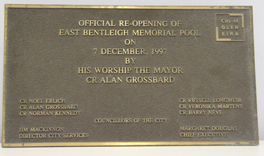
Plaque, commemorative, c. 1997
Plaque was previously located on the front wall of the East Bentleigh Memorial Pool alongside the original City of Moorabbin Memorial Pool plaques. The plaques were removed from the wall when the building was demolished for the GESAC development. The Moorabbin pool plaques were restored and relocated to the rhs wall in the entrance to GESAC. Plaque, bronze rectangular with polished bronze border and relief lettering and brown textured background. The plaque commemorates the official re-opening of the East Bentleigh Memorial Pool by the Mayor, Cr Alan Grossbard in 1997.Polished bronze relief lettering in upper centre of plaque: "OFFICIAL RE-OPENING OF / EAST BENTLEIGH MEMORIAL POOL / ON / 7 DECEMBER, 1997 / BY / HIS WORSHIP THE MAYOR / CR ALAN GROSSBARD" lhs, rhs, centre: CR NOEL ERLICH / CR ALAN GROSSBARD / COUNCILLORS OF THE CITY / CR RUSSELL LONGMUIR / CR VERONIKA MARTENS / CR BARRY NEVE / JIM MACKINNON / DIRECTOR CITY SERVICES / MARGARET DOUGLAS / CHIEF EXECUTIVE" -
 Sunbury Family History and Heritage Society Inc.
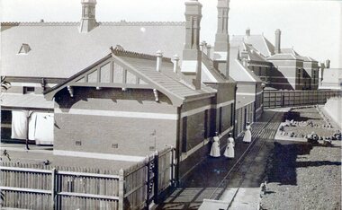
Photograph, Sunbury Asylum, c1920s
The brick buildings in the photograph are of the former Sunbury Asylum and F3 Ward is in the foreground. Initially the site on Jackson Hill also known as She0ak Hill opened as an Industrial School for orphaned or neglected children and in 1879 it became an asylum where it continued to function as an asylum until the Victorian Government closed it on 20th November 1992.The Sunbury Asylum played an important part in Sunbury and wider community's development over 150 years. throughout its existence there was much interaction between the residents, staff and local community, many of whom were employed at 'The Hill' as it was known locally. A sepia non-digital photograph of a large brick hospital building with three nurses standing outside it on a narrow pathway edging a garden bed. A picket fence is at the rear of the building enclosing a small yard where washing is drying on the line.sunbury asylum, jackson hill, caloola, sheoak hill, ward f3 -
 Sunbury Family History and Heritage Society Inc.
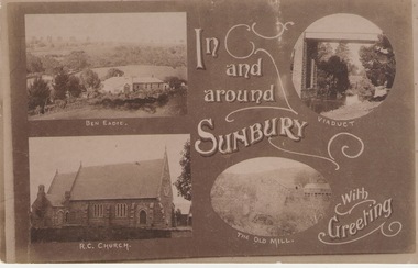
Post Card, Inb and around Sunbury
The post card is one of a set of commercial cards produced for Sunbury. Each card featured particular buildings or places of interest in the town. This card included Ben Eadie winery, Our Lady of Mt. Carmel Catholic Church, the former old mill by Jacksons Creek and the railway viaduct and bridge at Rupertswood. All the buildings featured on the card are of historical significance to Sunbury's early development.A post card featuring a collage four sepia views of Sunbury. The following greeting is written on the card: In and around Sunbury with Greeting. ben eadie winery, our lady of mount carmel catholic church, railway viaduct, the old mill -
 Sunbury Family History and Heritage Society Inc.
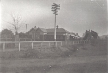
Photograph, c.1910
The building in the photograph is the Sunbury Railway Station in Brook Street and before it underwent renovations and externaL changes.The establishment of the railway in Sunbury in 1859 was an important development in the town's history and fore the Bendigo regional rail network.A black and white photograph of a weatherboard building behind a post and rail fence with a tall power pole in front of the building. A roadway is in front of the building.sunbury railway station -
 Sunbury Family History and Heritage Society Inc.
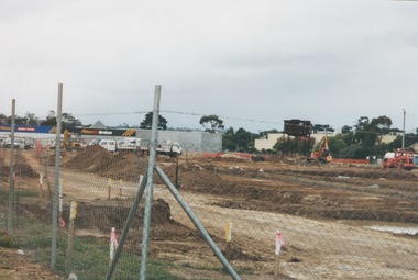
Photograph, 2000
Excavation work to remove the grasslands and trees on the railway land on the west side of the Sunbury Station to make way for commercial development on that side of the line.A coloured photograph of excavation work in operation on land which has cyclone fencing around its perimeter. There are buildings in the middle distance beyond the work site.sunbury railway station -
 Sunbury Family History and Heritage Society Inc.
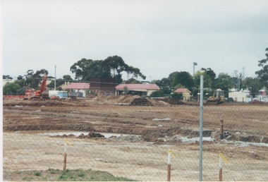
Photograph, 13 April 2000
In 2000 work commenced on the further development of railway land on the west side of Sunbury station for the construction of commercial and entertainment facilities. Prior to this time the land had been undeveloped and was often used to accommodate visiting circus troupes. Cereal storage silos also occupied this area for some time. The development of this area has been a reflection of the rapid expansion of settlement within Sunbury and surrounding areas that occurred during the early years of the twentieth century.A coloured photograph of a fenced off area undergoing development with earthmoving equipment and trucks in operation and some commercial buildings visible in the middle distance.sunbury railway station -
 Sunbury Family History and Heritage Society Inc.
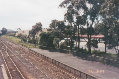
Photograph, 25th July 1995
The photograph of Sunbury Station was taken from the pedestrian bridge and is looking north to take in the Sunbury Square shopping centre buildings and the bus terminal which are on the Platform 1 or east side of the station.During the 1990s much development took place in Sunbury and the station precinct became a commercial hub.A coloured photograph of a railway station and a Coles Supermarket in the middle distance as well as a bus terminal. -
 Sunbury Family History and Heritage Society Inc.
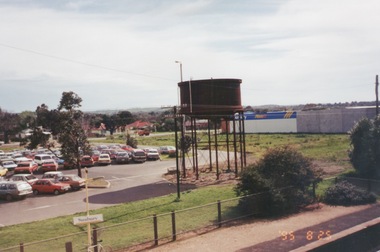
Photograph, 25th
The photograph of Sunbury was taken from the pedestrian bridge at the railway station and is looking NW to Horne Street and beyond. The water tower in the foreground was used to pump water into the steam train engines. Then commercial development on the site was built shortly before this photograph was taken.A coloured photograph of an elevated view of Sunbury with a metal water tower in the foreground and a car park with commercial buildings in the middle distance.sunbury, sunbury railway station, horne street -
 Sunbury Family History and Heritage Society Inc.
Photograph, 15th August 1995
The house was the former station master's residence. When the photograph was taken it served as a restaurant. In the late 1990s it was demolished to make way for larger commercial development.The former stationmaster's residence was one of the important buildings in Sunbury.A coloured photograph of a cream weatherboard house with light green trims surrounded by a garden. Four cars are parked outside the house.sunbury railway station, stationmaster's residence, brook street -
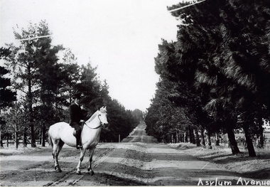 Sunbury Family History and Heritage Society Inc.
Photograph, c1900s
The man on the horse was photographed close to the main entrance of The Avenue which was the main approach to the former Sunbury Asylum. In later years the conifer trees were replaced with oak trees and today The Avenue is still the main road leading into Jacksons Hill, the housing estate that has been built on the former Sunbury Asylum land.The housing development on the former Sunbury Asylum site began in the 1980s. A black and white photograph of a man astride a white horse standing on an unmade road with an avenue of tall trees growing on either side of the formed road. A building is just visible in the distance.the avenue, sunbury as, jacksons hill -
 Clunes Museum
Plan - Building Plans, Proposed Layout Plan Clunes Neighborhood House, 12 June 2009
Architectural plan of proposed Clunes Neighborhood House Free Lending Library Development.A1 size architectural plan of proposed Clunes Neighborhood House Free Lending Library Development. Includes floor plan, front and side elevations. Dated 12 June 2009 by Kevyn Joy Architects.clunes neighbourhood house, kevyn joy architects, building plans -
 Surrey Hills Historical Society Collection
Book, Raheen: a house and its people, 2007
Raheen is a 120 year old Victorian house owned by Richard and Jeanne Pratt. Mrs Jeanne Pratt commissioned the book and this copy was presented to Sue Barnett on a visit by members of the Boroondara Historical Societies. The visit was organised by local member Mr Josh Frydenburg. 92p. ill. bibliog., Raheen was a grand two-storey red brick house in the Italianate Style, with a prominent tower and an arcaded loggia on two levels. This book explores its history, restoration and further development over many years. 92p. ill. bibliog., Raheen was a grand two-storey red brick house in the Italianate Style, with a prominent tower and an arcaded loggia on two levels. This book explores its history, restoration and further development over many years.Endpaper: Surrey Hills Historical Society / Jeanne Pratt / 27/7/2013(mr) ian allen oam, (mr) william lawrence bailieu, ehud barak, (dr) james broadbent, (mr) robert bruce, (mr) george h w bush, (mrs) barbara pierce bush, (mr) arthur calwell, (ms) jane dennithorne, (mr) eamon de valera, (sir) james augustine gobbo, (mr) lloyd hill, (mr) william morris hughes, (lord) (mr) immanuel jakobovits, (mr) philip johnson, (cardinal) (mr) walter kaspar, moshe katsav, (mr) james robert knox, (mr) terence lane, (mr) edward latham, (mr) michael lehany, (dr) (mr) miles lewis, (mr) sam lipski am, (sir) (mr) thomas francis little, (mr) peter lovell, (mr) egidio lunardon, (mr) (cardinal) jean-marie lustiger, (mr) daniel patrick mannix, (sir) (mr) robert gordon menzies, (mr) henry miller, (mr) glen murcutt ao, (mr) benjamin netanyahu, (mr) ngo dinh diem, (mr) phillip nikolitsis, i (eoh) m(eng) pei, (mr) shimon peres, (mr) joseph reed, (mr) yves st laurent, (mr) william salway, (mr) james henry scullin, jessie serle, (mr) justin david simonds, (mrs) heliose waislitz, (miss) heliose pratt, (mr) john wren, (sir) (mr) henry john wrixon, (mr) richard pratt, (mrs) jeanne pratt, raheen, historical buildings, kew, victoria, italianate style, house names -
 Surrey Hills Historical Society Collection
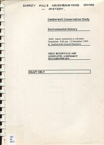
Report, Camberwell conservation study: environmental history 1989 : Draft only, 10/12/1989
Full title on cover: Camberwell Conservation Study: environmental history. Draft report submitted to Advisory Committee, 12 December 1989 at Camberwell Council Chambers An environmental history draft report prepared for City of Camberwell as part of the City of Camberwell Conservation Study. Presented in 2 volumes. Charts the development of the suburb of Camberwell. Beginning late 1880s.An environmental history draft report prepared for City of Camberwell as part of the City of Camberwell Conservation Study. Presented in 2 volumes. Charts the development of the suburb of Camberwell. Beginning late 1880s.camberwell, land places and structures, buildings - conservation and restoration, buildings, structures and establishments, social history, public housing, camberwell estate, st john's wood (wanganella) -
 Surrey Hills Historical Society Collection
Book, These Walls Speak Volumes : a History of Mechanics Institute in Victoria, 2015
One of the most comprehensive studies of mechanics institute in Victoria. Beginning from 1839 to the present. Arguably Victoria's oldest and most influential surviving institution. History of approx.1,000 institutes including building status, social adult education, library history, heritage listings, plus thematic essays about the Mechanic Institute movement and development. Includes: role of woman, architecture, schools of art and design and schools of mines. This is the most comprehensive study of mechanics institute in Victoria.History of approx.1,000 institutes including building status, social adult education, library history, heritage listings, plus thematic essays about the Mechanic Institute movement and development. Includes: role of woman, architecture, schools of art and design and schools of mines. This is the most comprehensive study of mechanics institute in Victoria.Signed by co-author Ken James on title page.libraries, educational and research establishments, mechanics institutes, surrey hall, (mr) ken james, (ms) pam baragwanath -
 Surrey Hills Historical Society Collection
Book, Remembering Melbourne 1850-1960, 2016
This book includes more than 700 photos tracing the development and changes over more than a century. More than 30 historians wrote chapters for the book including Sue Barnett, on Surrey Hills.This book includes more than 700 photos tracing the development and changes over more than a century. More than 30 historians wrote chapters for the book including Sue Barnett, on Surrey Hills.surrey hills, (ms) sue barnett, buildings - victoria - melbourne - history, historic buildings - victoria - melbourne, melbourne history, melbourne (vic) - buildings, structures, etc -
 Surrey Hills Historical Society Collection
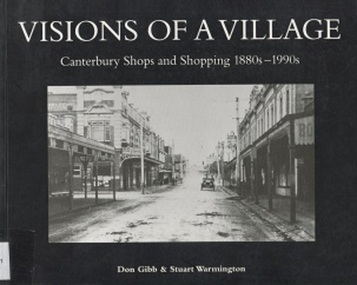
Book, Visions of a Village : Canterbury shops and shopping 1880s-1990s, 1995
Focussing on the growth and activities that took place in the shopping and service centre of Canterbury and Maling Roads in Canterbury from the 1880s to the present, it is partly a guide book to the present buildings of the centre through the streetscapes and brief lives of each of the premises.Focussing on the growth and activities that took place in the shopping and service centre of Canterbury and Maling Roads in Canterbury from the 1880s to the present, it is partly a guide book to the present buildings of the centre through the streetscapes and brief lives of each of the premises. illus. of streetscapes, indexshops, canterbury, maling road, (mr) george robinson, rochester road, j weymouth, railways, m white, hindson buildings, (mrs) - hillier, f g wilson, s huckerby, g cox, (mr) george cornell, lawson brothers, retail trade, commercial development -
 Surrey Hills Historical Society Collection
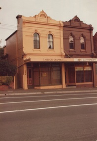
Photograph, 386-384 Canterbury Road Surrey Hills
The donor, Bob Lennox believed that these were the work of his great-grandfather William Lennox and his builders. William and his son were plasterers and often used the shell motif which is seen on the pediment of the buildings. These two terraces were part of the retail development of five terraces along Canterbury Road which were constructed on land subdivided from the parcel of land originally owned by John Woodhead. The Alan Holt register of properties in 3127 gives a list of proprietors / residents at the beginning of each decade from 1890-1980. There are also earlier photos depicting these buildings in the collection. These buildings have been included in the City of Boroondara Heritage Overlay Union Road Commercial Precinct 2011, Surrey Hills.These buildings were amongst the first commercial buildings serving the area of Surrey Hills and followed the extension of the railway from Camberwell in 1883.A colour photo with rounded corners taken from slightly diagonally across Canterbury Road from 2 double-storey Victorian style buildings. Both have the decorative shell motif in the pediment.Back of photo in green pencil "CANTERBURY RD SURREY HILLS / EAST OF UNION RD"victorian style, allegro graphics, william lennox, 386-384 canterbury road, shops, victorian terraces, canterbury road, surrey hills, john woodhead, heritage overlay union road commercial precinct 2011, heritage overlays -
 Surrey Hills Historical Society Collection
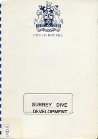
Book, Surrey Dive Development, Nov. 1986
A report on the proposed development of the Surrey Dive and adjacent areas. It includes topography, site services, buildings, usage of the area including fishing, boating, model boats.An A4 spiral bound report.surrey dive, box hill brick company, surrey park, shire of nunawading, scott and furphy engineers pty ltd, box hill -
 Surrey Hills Historical Society Collection
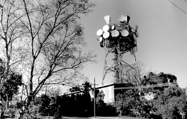
Photo, Telecom tower, Canterbury Road
This photo of the Telecom Tower was one of a series of photos taken of landmarks and houses of the area by Ken Hall in c1980. The PMG / Telecom / Telstra tower was built in 1961-1963 as a relay station to support television and radio links between city and regional broadcasting stations. The tower itself was 45 m in height with a 2 storey building for equipment and staff surrounded by garden. From the beginning it was opposed by local residents. In response to a Telstra application to replace it with a 40m slimline monopole, the City of Whitehorse controversially sought to have the structure heritage-listed, a move which caused much debate. In May 2015 Council ultimately rescinded its decision and gave permission for demolition, however Telstra deemed the permit conditions to be too restrictive and decided to continue to use the tower. The permit (to replace the tower) expired in September 2017. A black and white photo of local landmark visible from many vantage points in Surrey Hills and surrounding area, as it was built on the high point of the area.telecommunications tower, city of whitehorse, heritage overlay, heritage study, development, pmg tower, telstra, telecom, harding street, canterbury road -
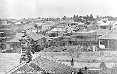 Surrey Hills Historical Society Collection
Photograph, Surrey Hills - Looking East from Essex Road, circa 1900, c1900
Date is approximate. Two original post cards of this image - "Surrey Hills - looking East" - were donated by Stephen Wyatt on 10 March 2012. One is blank; the other has been sent to Mrs A Wyatt, C/O Mrs E Young, 'Grand View', Warburton from daughter Nellie from 'The Quantocks', Surrey Hills - postmarked 10 Dec 1906. There is also a reproduction of this image in a framed collage of Surrey Hills photos.This is the earliest known image of the Surrey Gardens. The layout was originally designed by William Guilfoyle, who also designed Melbourne’s Royal Botanic Gardens.Black and white photo taken from an early postcard. Taken from the roof of a house in Essex Road, it shows the development of housing between Essex and Union Roads and includes the section of land fenced off for the Surrey Gardens with paths roughly laid out, one existing tree but no tree planting. The houses depicted are largely Edwardian timber buildings with corrugated rooves. There are still some vacant blocks. Kirkland on Union Road can be seen in the distance, as can some of the shops along Canterbury Road.Lower LHS within original image: " Surrey Hills - Looking East"; on the rear "No 17" in black pen in top LH corner.edwardian style, residential development, kirkland, essex road, suffolk road, norfolk road, surrey gardens, post card -
 Surrey Hills Historical Society Collection
Work on paper - Photograph, Nethercourt Private Hospital, Surrey Hills, c 1924, 1924
Notes from a previous collection coordinator indicate that Miss Lucy Musselwhite (Lillywhite) opened the hospital in 1914 and Matron Eliza Tank took it over in 1921 and named it Nethercourt Private Hospital. However recent research suggests that Miss Musselwhite (name confirmed) moved from Tooronga to Wilson Street some time between 1903 and 1909. She and her mother Elizabeth are listed in the 1909 electoral rolls in Wilson Street and Lucy's occupation is given as nurse. (It is of course possible that the property was a residence only at this time and later opened as a private hospital.) The name Nethercourt was used prior to Matron Eliza Tank taking over. Her daughter Irene was also a nurse at Nethercourt. Lucy Musselwhite was born in 1873 in Hampshire. She married Henry James Dore in later life and lived in Brenbeal Street, Balwyn. She died in 1955. In 1930 / 1935 Matron Tank transferred the hospital to 219-223 Union Road. Later it was known as Norwich Hall / St Jude's. Mosgiel Hospital in Mont Albert Road also opened in 1924. After this time home births became less common. Nethercourt Hospital closed in the 1960s.Small hospitals such as this one were primarily used for midwifery, preceding the development of larger centralised general hospitals. Black and white photo of Nethercourt Private Hospital at 11 Wilson Street in c 1924 taken from the street in winter. The building is Victorian in style; block-fronted with lacework detail to the verandah and has 2 chimneys. It is set behind a wooden picket fence behind which is a well-manicured hedge which appears to have been grown across the front entrance gate.nethercourt private hospital, midwifery, hospitals, matron eliza tank, miss lucy musselwhite, miss irene tank, mrs irene anderson -
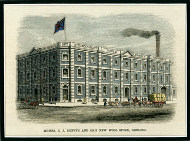 National Wool Museum
Newspaper Cutting, Messrs. C. J. Dennys and Co.'s New Wool Store Geelong, 10/9/1872
The Denny Lascelles Wool Warehouse was the first building in Victorian planned to facilitate storage, inspection and marketing of wool in one operation, and upon completion was the second largest store in the colony. CJ Denny's was largely responsible for establishment and development of the wool marketing industry in Geelong and is a figure of significance in the history of settlement in Geelong. The wool store, a basalt structure with cement rendered ornamentation, was erected for CJ Denny's and Co, in 1872 to the design of Jacob Pitman, Architect.Wood cut engraving of the Mesrs. C. J. Dennys and Co.'s New Wool Store Geelong, published in The Illustrated Australian News, 1872. The half page full colour illustration shows the newly constructed Wool Store with a bull drawn cart carrying full wool bales situated out the front of the store.Top margin: THE ILLUSTRATED AUSTRALIAN NEWS 201 Below image: Mesrs. C. J. Dennys and Co.'s New Wool Store Geelong Image signed, lower mid edge: WINSTON Image, on building: C.J. Dennys Wool Brokers 1872 C.J. Dennys & Co. Wool & Produce Warehousedenny lascelles wool warehouse, wool, dennys, wool store -
 Vision Australia
Image, 1983
An image of the extension work done at Kelaston in 1983 for the development of a low vision clinic, and the temporary premises in Mair Street that was utilised whilst the Howitt Street building was unavailable.2 x B/W photographsassociation for the blind, kelaston home (ballarat) -
 Port Fairy Historical Society Museum and Archives
Photograph, Jock Varcoe
... beach development road street building Coloured photograph ...South Beach DevelopmentColoured photograph of Road building on South Beach Estatesouth beach, development, road, street, building -
 Port Fairy Historical Society Museum and Archives
Photograph
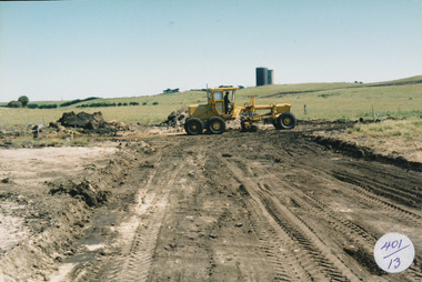
South Beach Development south beach, development, grader, water tower, street, building -
 Port Fairy Historical Society Museum and Archives
Photograph
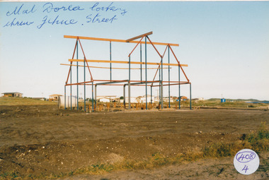
... beach development mal dora house Building jehu street Photograph ...South Beach Development south beach, development, mal dora, house, building, jehu street -
 Port Fairy Historical Society Museum and Archives
Photograph
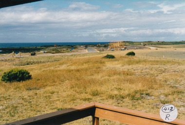
... beach development House building street road Photograph ...South Beach Developement south beach, development, house, building, street, road -
 Port Fairy Historical Society Museum and Archives
Photograph
South Beach Development south beach, development, ocean drive, mal dorea, house building, road, street -
 Port Fairy Historical Society Museum and Archives
Photograph
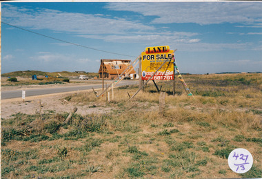
South Beach Development south beach, development, sale, sign, mal dora, house, building -
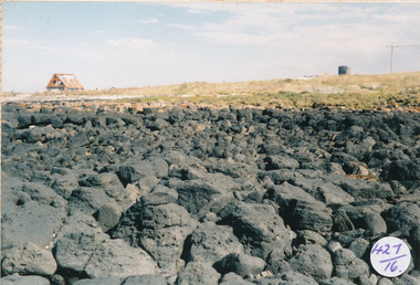 Port Fairy Historical Society Museum and Archives
Photograph
South Beach Development looking from rocks to Mal Dorea’s housesouth beach, development, rocks, bluestone, mal dorea, house, building