Showing 1357 items matching "form and colour"
-
 Buninyong & District Historical Society
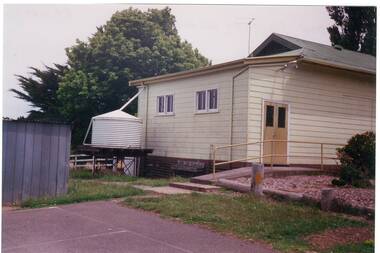
Photograph - Colour photograph, Colour photograph of the rear of the main building of Yendon Primary School 1994
Yendon Primary School operated as a State School from 1877 and ceased operating in 1993. The School initially operated as the Buninyong East Common School from 1864.The children of railway workers from the Ballarat- Geelong railway would have formed much of the opening enrolment of the school.Colour photograph showing the rear of the former main school building of Yendon Primary and part of the playground.Yendon Primary School 1994education, yendon, state schools -
 Eltham District Historical Society Inc
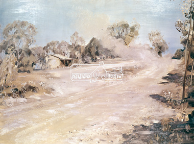
Photograph, "Dust to Dust" - Neil Douglas, 1971
Douglas' painting shows a mud farm cottage in Kangaroo Ground. The mud brick cottage at 145 Henley Road is on the Victorian Heritage Database This photo forms part of a collection of photographs gathered by the Shire of Eltham for their centenary project book, "Pioneers and Painters: 100 years of the Shire of Eltham" by Alan Marshall (1971). The collection of over 500 images is held in partnership between Eltham District Historical Society and Yarra Plenty Regional Library (Eltham Library) and is now formally known as the 'The Shire of Eltham Pioneers Photograph Collection.' It is significant in being the first community sourced collection representing the places and people of the Shire's first one hundred years.4 x 5 inch colour reversal film (2) Condition: May not be true to colour of original work. Scanned from a 4 x 5 inch colour transparency which was taken c.1970 (approx. 50 years old) and which has undergone significant colour degradation towards the red spectrum. Allowances made for colour cast correction in scan with best guess for white balance. Significant light flare is reflected off glossy surface of original work at camera lens at lower left and right sides causing quality issues. sepp, shire of eltham pioneers photograph collection, neil douglas, kangaroo ground, roads -
 Eltham District Historical Society Inc
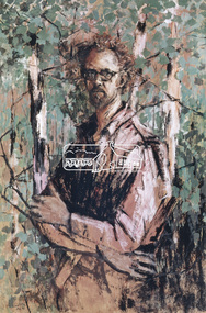
Photograph, Self Portrait - Clifton Pugh (1962), 1971
Clifton Pugh (1924-1990) was born at Richmond Victoria, and educated at various schools including Briar Hill Primary, Eltham Higher Elementary School and Ivanhoe Grammar. He studied art at the National Gallery School of Victoria 1948-52. Pugh is recognised as a one of Australia’s foremost painters. He is represented in major galleries throughout the country and overseas. He founded the “Dunmoochin” artists colony at Cottles Bridge.This photo forms part of a collection of photographs gathered by the Shire of Eltham for their centenary project book, "Pioneers and Painters: 100 years of the Shire of Eltham" by Alan Marshall (1971). The collection of over 500 images is held in partnership between Eltham District Historical Society and Yarra Plenty Regional Library (Eltham Library) and is now formally known as the 'The Shire of Eltham Pioneers Photograph Collection.' It is significant in being the first community sourced collection representing the places and people of the Shire's first one hundred years.4 x 5 inch colour reversal film (1) Condition: May not be true to colour of original work. Scanned from a 4 x 5 inch colour transparency which was taken c.1970 (approx. 50 years old) and which has undergone significant colour degradation towards the red spectrum. Allowances made for colour cast correction in scan with best guess for white balance. In some cases, significant light flare is reflected off glossy surface of original work at camera lens causing quality issues.clifton pugh, sepp, shire of eltham pioneers photograph collection, self portrait -
 Forests Commission Retired Personnel Association (FCRPA)
Beechworth FCV District office sign
This sign proudly hung outside the Forests Commission Victoria (FCV) Beechworth office which is now site of the Forestry Heritage Museum. The granite building in the Beechworth's historic precinct was once the Gold Warden's Office and is one of the town's original buildings. The FCV was the main government authority responsible for management and protection of State forests in Victoria between 1918 and 1983. The Commission was responsible for ″forest policy, prevention and suppression of bushfires, issuing leases and licences, planting and thinning of forests, the development of plantations, reforestation, nurseries, forestry education, the development of commercial timber harvesting and marketing of produce, building and maintaining forest roads, provision of recreation facilities, protection of water, soils and wildlife, forest research and making recommendations on the acquisition or alienation of land for forest purposes″. The Forests Commission had a long and proud history of innovation and of managing Victoria's State forests but in September 1983 lost its discrete identity when it was merged into the newly formed Victorian Department of Conservation, Forests and Lands (CFL) along with the Crown Lands and Survey Department, National Park Service, Soil Conservation Authority and Fisheries and Wildlife Service. After the amalgamation the management of State forests and the forestry profession continued but the tempo of change accelerated, with many more departmental restructures occurring over the subsequent four decades. Responsibilities are currently split between the Department of Energy, Environment and Climate Action (DEECA), Forests Fire Management Victoria (FFMV), Parks Victoria, Melbourne Water, Alpine Resorts Commission, the State Government-owned commercial entity VicForests and the privately owned Hancock Victorian Plantations (HVP).Large office sign. Hand painted in traditional FCV mission brown and gold colour scheme.forests commission victoria (fcv), forest signs -
 Kew Historical Society Inc
Clothing - Protective Wear, Apron, 1950s
One of a collection of fourteen items of protective wear and household textiles donated by Lisa Sylvan, a long-term resident of Kew, Five of the items are homemade aprons made and worn by her mother. Of the seven pinafores, three identical but differently sized pinafores were made in her parents' factory, while the other three are handmade. The handmade aprons and pinafores are representative samples of women's work, possibly from published patterns, using fabrics originally deigned for dresses. Typically, contrasting fabrics and colours were selected to provide visual interest. The donation also includes a hand embroidered linen supper cloth and a commercially produced 'birds of Australia' printed table cloth. Most of the collection derives from the 1950s.Although not uncommon, hand-made protective clothing in the form of aprons and pinafores often represents samples and styles of 'women's work' using remnant fabrics often designed for other purposes. While generally utilitarian, women found means of gracing these items by the use brightly coloured fabric or patterns, the positioning of pockets and the use of contrasting fabrics to provide visual interest.Multicoloured cotton apron using a fabric design employing floral emblems and figurative detail. The apron is hemmed with a pleated fabric of a different colouraprons, protective clothing, handmade clothing, costume accessories, lisa sylvan -
 Glenelg Shire Council Cultural Collection
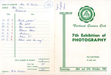
Document - Camera Club Entry Form - 7th exhibition of photograph 1967, n.d
Four page entry form for Portland Camera Club's 7th exhibition of photography, 26th and 27th October 1967. Contains information on classes, judges, general conditions of entry etc. Back page is actual entry form. White paper, green print, Portland Camera Club logo on front.Front: 'Impact, composition, colour' - handwritten, blue biro. Back: 'Name of Exhibitor 'Miss B. Vivian' and details of exhibits - handwritten, blue biroportland camera club -
 Bendigo Historical Society Inc.
Photograph - 1853 Bendigo Goldfields Petition, abt 1990-2019
The Red Ribbon Movement of 1853 represented a significant series of events in the history of Bendigo. During that year there was much agitation on the Bendigo gold fields, particularly during July and August of 1853, directed against the payment of what the miners called a tax - a licence fee of thirty shillings ($3) a month for the right to search for gold on what was declared Crown land. They had to pay the licence whether they found gold or not. The miners, or diggers as they were called, also resented the means used by the authorities at the time to collect the gold licence - through so-called 'digger hunts'. The miners were expected to carry their licences with them, and the police, who were often untrained, used harsh methods to check these licences. In Bendigo, the miners took to wearing a red ribbon ‘as a symbol of their protest against the licence. Red was a very common colour in items such as shirts, so was readily available. Shopkeepers too tied red ribbons to their premises as a sign of support for the miners. It should be remembered at that time virtually everyone was a miner. The diggers also had their own banner, designed by William Dexter, a china painter from Devon. This flag showed the pick, shovel and cradle representing labour, the scales representing justice, the Roman bundle of sticks meaning unity and the kangaroo and emu of Australia Many thousands of Bendigo miners signed a petition to La Trobe, the Governor of Victoria, protesting against the licence fee. When the Governor rejected the petition, thousands of diggers marched in peaceful protest. Miners from White Hills, Eaglehawk, Golden Square, Kangaroo Flat as well as from Bendigo Flat, converged on what is now Pall Mall and View Point, surrounding the ~government camp on Camp Hill. The camp had been reinforced with soldiers of the 40 Regiment, as the Government feared bloodshed. The miners then gathered on the hill behind View Point to hear from their leaders - among them George Thomson, Captain Harrison, Captain Brown and W.D.C. Denovan. They resolved to pay a token fee often shillings ($1) for the September licence, whenthey met with Commissioners Panton and Wright on Camp Hill. Although Wright and Panton were sympathetic to the miners, the offer was rejected, but no licence fees were collected for September. Thus a possible bloody conflict was averted by the common sense shown by the miners' leaders and the commissioners. It was a truly democratic protest against arbitrary government and preceded the Eureka Stockade Incident by over a year. Bendigo Historical Society Committee on a Tram, two photos, one of five people standing behind a display cabinet, and the second one a Banner stretched across the tram. On the rear of the photo is "L-R Jim Evans, Terry Davidson, Ron Monro." Second from left is Jim Evans (President) and fourth from the left is Terry Davidson, with extreme right, Ron Munro (Vice President). In the cabinet is the 1853 Bendigo Goldfields Petition (Red Ribbon Rebellion) The society holds the petition in digital form. The diggers had their own banner, designed by William Dexter, a china painter from Devon. This flag showed the pick, shovel and cradle representing labour, the scales representing justice, the Roman bundle of sticks meaning unity and the kangaroo and emu of Australia history, bendigo, tram, 1853 bendigo goldfields petition, red ribbon rebellions -
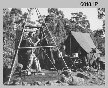 Bendigo Military Museum
Photograph - Royal Australian Survey Corps Surveyors in the Field, Army Survey Regiment, 1950s to 1970s
These three photographs were most likely taken from the 1950s to the 1970s. The RASvy surveyor in each photograph was taking angular measurements with the observer recording their readings on a booking form. They were probably employed in establishing mapping and geodetic control operations or the surveyors may have been in training. Photo .1P was possibly taken at Mount Alexander in Central Victoria, a location close to Bendigo, as the stone cairn in the background of the photo appears to be identical to the cairn presently located on top of the mountain. Personnel and location have been confirmed on another photo in the collection with annotation. These three photographs are of surveyors in the field undertaking observations using theodolites. The photographs were printed on photographic paper and are part of the Army Survey Regiment’s Collection. The photographs were scanned at 300 dpi. .1) - Photo, black & white, c1950s. Unidentified personnel undertaking observations with a Tavistock geodetic theodolite. .2) – Photo, colour, mounted on card, c1960s. Unidentified personnel undertaking observations with a Kern DKM2 theodolite. .3) - Photo, colour, c1970s. Unidentified personnel undertaking observations with a theodolite..1 – not annotated .2 –annotated on front “Kern DKM2, TOPO 10” royal australian survey corps, rasvy, army survey regiment, army svy regt, fortuna, asr, surveying -
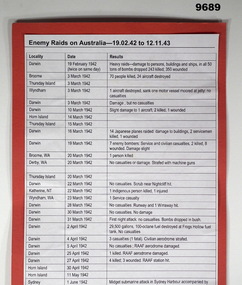 Bendigo Military Museum
Document - ENEMY RAIDS ON AUSTRALIA, WW2, Post WW2
Information printed on chart: "Enemy Raids on Australia 19.02.42 to 12.11.43" The document lists in chart form the Enemy raids on Australia under the headings "Locality", "Date", "Results". "Locality" includes Darwin, Broome, Thursday Island, Wyndham, Horn Island, Derby WA, Katherine NT, Horn Island, Sydney, Newcastle, Townsville, Port Hedland, Mossman (90km north of Cairns), Milingimbi, Wessell Island, Exmouth Gulf, Fenton Aerodrome, Coomallie Fenton, Onslow, Drysdale Mission.Chart - white colour paper adhered to red coloured cardboard for display purposes. Facsimile copy with black ink print. Unknown source.document, chart facsimile, ww2, australia -
 Wangaratta RSL Sub Branch
Photograph, 2003
Image depicts a group of 11 men who served with the 2/24 Battalion during World War 2 attending annual reunion in Wangaratta in November 2003. They include:- Back Row: VX34601 Murray BURLES DOB 12/9/1919 POB Hobart; Bill WILLIAMS VX43349 Leslie HANSEN DOB 26/1/1920 POB Coburg POW 5/1941; VX31699 Alan NICHOLSON DOB 27/10/1918 POB Korumburra POW 1/5/1941; VX15247 Alan MacFARLANE DOB 13/9/1918 POB England; Front Row: VX44006 Robert CLARKE DOB 15/1/1920 POB Glenhuntly; VX48597 Dr Guy ROBERTSON DOB 4/7/1918 POB St Arnaud, RMO VX34767 Thomas ANDERSON DOB 31/5/1914 POB Hamilton POW 5/1941 VX29686 Gordon POIDEVIN DOB 30/3/1917 POB Corowa POW 3/5/1941; VX45356 Douglas GRAY DOB 16/8/1918 POB Bendigo (Bugler) The 2/24th Battalion was an infantry battalion of the Australian Army, which served during World War II .A unit of all-volunteers, it was formed in July 1940 from primarily Victorian volunteers and was known as "Wangaratta's Own" because of the time the battalion spent in the town during its formative period prior to deployment overseas. It served in North Africa in 1941–1942 as part of the 26th Brigade, which was assigned to the 7th Division, before being reassigned to the 9th Division. In early 1943, the battalion returned to Australia and later took part in campaigns against the Japanese in New Guinea in 1943–1944 and Borneo in 1945, before being disbanded in 1946. The 2/24th suffered the highest number of casualties of any 2nd AIF infantry battalion. The Unit was granted the Freedom of the City by the Rural City of Wangaratta in 1990 and one of the first, if not the first, to receive this type of honour.Colour photograph of 11 men standing and seated in two rows 2/24th battalion, wangaratta -
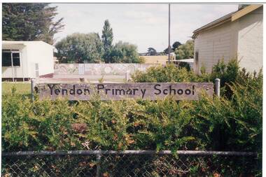 Buninyong & District Historical Society
Photograph - Colour photograph, Part of the former grounds and buildings of the former Yendon Primary School featuring the school sign
Yendon Primary School operated as a State School from 1877 and ceased operating in 1993. The School initially operated as the Buninyong East Common School from 1864.The children of railway workers from the Ballarat- Geelong railway would have formed much of the opening enrolment of the school.Colour photograph of part of two school buildings and the grounds of the school featuring the sign "Yendon Primary School" on the school fence.Yendon Primary School 1994education, yendon, state schools -
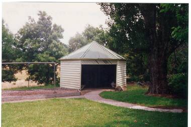 Buninyong & District Historical Society
Photograph - Colour photograph, Six sided shelter shed of the former Yendon Primary School 1994
Yendon Primary School operated as a State School from 1877 and ceased operating in 1993. The School initially operated as the Buninyong East Common School from 1864.The children of railway workers from the Ballarat- Geelong railway would have formed much of the opening enrolment of the school.Colour photograph of a six sided shelter shed in the grounds of the former Yendon Primary School 1994Shelter shed Yendon Primary School 1994 6 sidededucation, yendon, state schools -
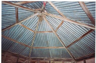 Buninyong & District Historical Society
Photograph - Colour photograph, Colour photograph of the rear of the Yendon Primary School 1994
Yendon Primary School operated as a State School from 1877 and ceased operating in 1993. The School initially operated as the Buninyong East Common School from 1864.The children of railway workers from the Ballarat- Geelong railway would have formed much of the opening enrolment of the school.Colour photograph showing the internal roof structure of a six sided shelter shed in the grounds of the former Yendon Primary School 1994Yendon Primary School 1994 Shelter Shed Roof (internal)education, yendon, state schools -
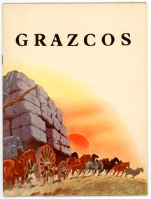 National Wool Museum
Document - Grazcos Annual Report, Grazcos Co-operative Limited, 1949
The co-operative was registered in 1919 as the Graziers Co-op Shearing Company Limited. It changed its name in September 1948 to Grazcos Co-operative Ltd. In 1981 the co-operative merged with Farmers & Graziers Co-op Ltd to form Farmers Grazcos Co-op Ltd. This item is part of a collection of Annual Reports from Grazcos dated from 1949 - 1980.Booklet featuring a colour graphic on the cover of horses pulling a cart load of wool bales, with the sun setting in the background and black printed text.front: GRAZCOSagricultural co-operative, agricultural wholesaling, annual reports, rural life, rural industry, business, corporate body -
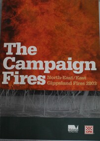 Wodonga & District Historical Society Inc
Book - The Campaign Fires - North-East/East Gippsland Fires 2003, Lyndel Hunter, 2003
A description of efforts to fight the bushfires in Gippsland in 2003, including maps and illustrations This volume was published as a tribute to the work of staff and volunteers who put themselves at risk to protect local communities. It shows the impact on those communities in Victoria and the support they gave to those involved in fighting largest bushfires in Victoria for 60 years. The Alpine bushfires started on 8 January 2003, a day of Total Fire Ban. Lightning ignited 87 fires in the North-East and East Gippsland regions. Eight of these fires were unable to be contained; they joined together to form the largest fire in Victoria since the Black Friday fires in 1939. The majority of the area burnt in Victoria was public land, 1.19 million hectares of parks and forests, including 60 per cent of the Alpine National Park and 81 per cent of the Mt Buffalo National Park. Firefighting efforts were made difficult in hard to access, remote forest terrain. Approximately 90,000 hectares of private land was burnt.This publication of 119 pages features text, colour images, maps and detailed information related to the 2003 bushfires in Victoria.non-fictionA description of efforts to fight the bushfires in Gippsland in 2003, including maps and illustrations This volume was published as a tribute to the work of staff and volunteers who put themselves at risk to protect local communities. It shows the impact on those communities in Victoria and the support they gave to those involved in fighting largest bushfires in Victoria for 60 years. The Alpine bushfires started on 8 January 2003, a day of Total Fire Ban. Lightning ignited 87 fires in the North-East and East Gippsland regions. Eight of these fires were unable to be contained; they joined together to form the largest fire in Victoria since the Black Friday fires in 1939. The majority of the area burnt in Victoria was public land, 1.19 million hectares of parks and forests, including 60 per cent of the Alpine National Park and 81 per cent of the Mt Buffalo National Park. Firefighting efforts were made difficult in hard to access, remote forest terrain. Approximately 90,000 hectares of private land was burnt.forest fires -- victoria, bushfires, fires prevention and control -
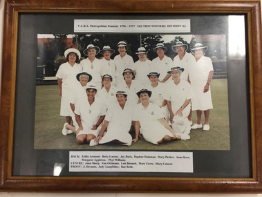 Kew Historical Society Inc
Photograph, VLBA Metropolitan Pennant Section Winners Division A2, 1997
Sports Clubs in Kew in the final decades of the 19th century and in the early 20th century were often umbrella organisations with facilities for a number of sports. Typically in Kew, this included teams in lawn bowls, tennis and croquet. The Kew Bowling Club was formed in 1880 while the privately owned Auburn Heights Recreation Club was opened in 1904. By 1998, the two Clubs decided to amalgamate at the Auburn Heights site in Barkers Road, forming the Kew Heights Sports Club. The combined club was itself taken over by the Melbourne Cricket Club in 2012 becoming MCC Kew Sports Club. In 2017 MCC Kew closed and its landholding was subsequently sold to Carey Baptist Grammar School. Both the Kew and Auburn Heights Clubs assembled important collections. These historically significant and large collections were donated to the Society in 2020. The collections include manuscripts, pictures, trophies, plans, honour boards etc. The combined collections of the four sporting clubs making up the collection number hundreds of items that are historically significant locally. They are also significant to the sporting history of the greater Melbourne area and to the sports of lawn bowls and tennis in Australia in the 19th and 20th centuries. The collection illuminates two of the Victorian historic themes - 'Building community life' through forming community organisations and 'Shaping cultural and creative life' by participating in sport and recreation.Framed and glazed colour photograph of the Kew Ladies Bowling Club team which won the VLBA Division A2 pennant in 1996-7kew bowling club, kew ladies bowling club, sports - kew (vic) -
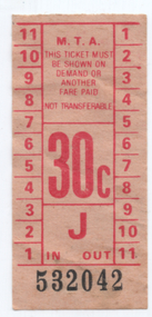 Melbourne Tram Museum
Ephemera - MTA 30c tram ticket, The Met, c1984
Sample of a Metropolitan Transit Authority 30c tram or bus ticket - red on off-white paper with a black number - No. 532042. Would have been issued soon after the MTA or The Met was formed and the start of many changes to the ticket system.Demonstrates tickets headed "MTA".30c MTA tram tickets - flimsy - paper, red colour on off white paper with number in black.tramways, tickets, mta -
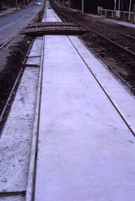 Melbourne Tram Museum
Slide - Set of 2, Keith Kings, 23/03/1968 12:00:00 AM
35mm Kodak white cardboard colour slide by Keith Kings of 23/3/68 and 6/4/68. .1 - Glenferrie Road Kooyong track renewal showing the first section of completed track. Shows two road crossovers. .2 - ditto, showing one end of the new crossover with temporary track on the right. See Keith's slide notes.Keith Kings stamp and number "20-19" and "20-32", with details of exposure. 23/3/68 and 6/4/68. .1 - "New concrete trackwork in Glenferrie Rd north from Kooyong railway Xing ready to be brought into use. Temporary track still in use at right" .2 - "New design for xover in Glenferrie Rd, near cnr Gardiner Rd Kooyong, Removable sections form the road surface and facilitate maintenance and renewal."trams, tramways, glenferrie road, trackwork, temporary track, kooyong -
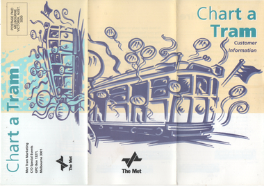 Melbourne Tram Museum
Pamphlet, Met Tram, "Chart a Tram - Customer information", c1995
Pamphlet produced by Met Tram Marketing about the hiring of trams - gives rates, seating capacity, depots and tram types. Has a list of depots and the contact details. Not dated, c1995. Has an enquiry form attached.Yields information about hiring a tram c1995.Pamphlet, 3 fold DLfull colour.met tram, tramways, tram hire, charters -
 Melbourne Tram Museum
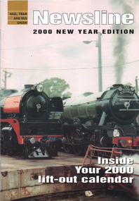
Magazine, Rail Tram & Bus Union (RTBU), "Newsline - 2000, 2001 & 2002 editions", 2000 to 2002
All issues contains a list of union officials at the time. Published by the Rail Tram and Bus Union. 2000 - articles by Peter Bourke, Branch Secretary, Trevor Dobbyn, Lou Di Gregorio - Trammies Report, Farewell to Unity Hall, services directory, adverts. Contained the calendar featuring B2 2112 at Luna Park 2001 - articles by Trevor Dobbyn as Branch Secretary, Marc Marotta Branch President, Lou Di Gregorio - Trammies Report, includes services directory and many adverts. 2002 - articles by Trevor Dobbyn as Branch Secretary, Marc Marotta Branch President, Lou Di Gregorio - Trammies Report, includes services directory and many adverts. Includes tributes for Ron Pearsall assistant national secretary and form ARU official Jim Frazer.Yields information about the RTBU and its activities and officials.Set of 3 A4 magazines, full colour centre stapled.; 2000 - 20 pages, 2001 - 16 pages, 2002 - 20 pages.trams, tramways, yarra trams, rtbu, unions, metlink, railways, tram 2112, b class -
 Melbourne Tram Museum
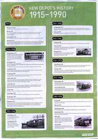
Poster, Hugh Waldron, "Kew Depot's History 1915 - 1990", 2015
Poster - "Kew Depot's History 1915 - 1990" - broken down into 8 eras from 1915 to 1990 with photos giving detailed dates of events that formed the Kew Depot's history. Issued as part of the depot centenary in 2015. Prepared by Hugh Waldron. Has the centenary logo in the top left-hand corner. Included is an A4 photocopy sheet giving details of the 8/12/1991 tram parade.Yields information about Kew tram depot's history from 1915 to 1990.A3 sheet printed in colour - two copies held and an A4 photocopied sheet.tramways, kew depot, celebrations, 100 years -
 Ballarat Heritage Services
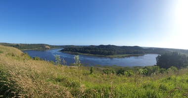
Photograph - Colour photograph, Tower Hill, 2022, 24/12/2022
Tower Hill is a volcanic formation believed to have erupted about 32,000 years ago. Its formation is known as a "nested maar" and it is the largest example of its type in Victoria. During formation, molten lava pushed its way up through the Earth’s crust and encountered a layer of water-bearing rock. Violent explosions followed creating a shallow crater which later filled with water to form the lake. Further eruptions occurred in the centre of this crater, creating the islands and cone shaped hills. In 1892 Tower Hill became Victoria’s first National Park. In 1961, Tower Hill became a State Game Reserve under the then Fisheries and Wildlife Department and a major re-vegetation program began. (https://www.towerhill.org.au/index.php/about-reserve/history, accessed 23 December 2019)Panaramic view of Tower Hill, Victoria.tower hill, volcano, crater -
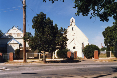
 Buninyong & District Historical Society
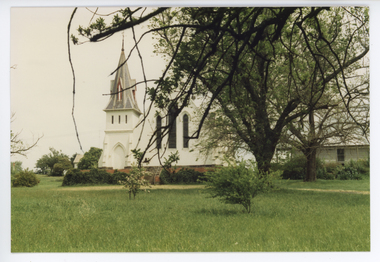
Photograph - Colour photograph, Buninyong Uniting Church, 1990s
Former Presbyterian church built in 1860, with foundation stone laid by Mrs Scott, snr, the oldest resident in the district on Tuesday 27th March 1860. In 1970 the congregations of the Presbyterian and Methodist Churches combined to form the Buninyong United Church. When the Uniting Church in Australia was formed in 1977, the church became the Buninyong Uniting Church.A very early church of the districtColour photograph of Buninyong Uniting Church, with two large trees near the adjacent church hall"Uniting Church Buninyong, 1990s"buninyong, uniting church, presbyterian church -
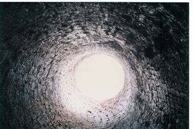 Buninyong & District Historical Society
Photograph - Colour photograph of interior of Lal Lal Blast Furnace, Interior of Lal Lal Blast Furnace
The Lal Lal Blast Furnace ruins is the only one from the nineteenth century remaining in Australia and represents the only attempt to smelt iron ore in VictoriaThe Lal Lal Iron Mining Company was formed in 1874 and reached its peak in 1884 when 160 men were employed View of interior of Lal Lal Blast FurnaceInside the Lal Lal Blast Furnace 1991lal lal, blast furnace, iron ore smelting, industrial history, mining -
 Charlton Golden Grains Museum Inc
Photograph, Brownjohn, Reg, Charlton Presbyterian Church and Hall mid-1980s, c.1890
The Presbyterian Church was built in 1871 by local contractor and grazier James Patterson of Nardoo Park, Woosang. The Presbyterian and Methodist Churches formed combined Parish in 1969. The buildings were demolished in 1989.Colour photograph of Charlton Presbyterian Church and Hall. The white-painted brick church building is on the right. The letters A . D 1871 in black are on the front of the church. There is also a bell tower, a small gothic arched window and a small round leadlight window on the front wall. The church hall is a white weatherboard building with blue trim. Red brick pillars stand at the entrance to the church and the hall. A large electricity pole is in front of the hall. james patterson, charlton, presbyterian, church, pastoral care -
 Eltham District Historical Society Inc
Photograph, Looking north across the Fitzsimons Lane Bridge over Yarra River between Eltham and Templestowe, c.1985, 1985c
Turnoff to Candlebark Park on right. The bridge over the Yarra River was initially opened September 22nd, 1961. Newspaper reports at the time of opening stated it linked Bolton Street, Eltham, with Fitzsimons Lane, Templestowe. In 1955 the Country Roads Board (CRB) produced survey plans that showed proposed land acquisition for the future bridge and road approaches. The 1955 plan shows that it was proposed to connect Fitzsimons Lane with Bolton Street in Eltham by a diagonal road across the river. The road connection would then continue along Bolton Street to Main Road. Prior to construction of the bridge the CRB modified the proposal significantly so that there was a new road parallel with Bolton Street and then curving to join Main Road at what was then its intersection with Old Eltham Road. This involved significantly more land acquisition and altered the pattern of land subdivision through this corridor. Initially the new road was just a single two-way carriageway as it would have required a significant widening of the cutting on the Shire of Eltham side of the river. The road was officially un-named but was known locally as the Eltham-Templestowe Road. The 1966 Melway street directory and other 1960s editions also listed the road as the Eltham-Templestowe Road. In December 1970, Eltham Shire Council, in pursuance of the provisions of the Local Government Act, named it Templestowe Road. The road was renamed Fitzsimons Lane around 1984 in conformity with the section south of the river. In 1991 a new bridge was built to the west of the original bridge. Fitzsimons Lane was widened to four traffic lanes although on the Eltham side this was done within the limits of the existing cutting. NEW BRIDGE STARTS THEM EXPLORING Without any fanfares, Country Roads Board workmen on Friday afternoon put the finishing touches to the approaches, removed the barricades, and let the traffic roll over the new Yarra bridge linking Bolton Street, Eltham, with Fitzsimons Lane, Templestowe. Over the week-end many “bridge watchers” who were making one of their periodic inspections of the progress on the new bridge found to their surprise that they could drive over it, so that people who had gone for a run out to Eltham suddenly found themselves wandering through Templestowe and Doncaster. By Monday the word of the bridge’s opening had got around sufficiently for many regular travellers to the city from Eltham and beyond to vary the monotony by going to town via Templestowe and Kew instead of through Heidelberg. They were surprised at the distances – about 3 ½ miles from Eltham to Templestowe, 6 miles from Eltham Shire hall to the Lower Heidelberg Road-Banksia Street intersection. NEW NEIGHBOURS For people on both sides of the river, the new bridge has turned distant friends into near neighbours. A Greensborough man on Sunday took 35 minutes to reach the home of a friend in East Doncaster, but the return trip over the new bridge took only 17 minutes. It will be some time yet before most people work out the possibilities in shorter and quicker trips form the north-eastern areas to the eastern and south-eastern suburbs. The coming of the warmer months will soon teach many, though the short cuts to Peninsular beaches and eastern suburban drive-ins. And before very long it is likely there will be a Tramways bus running from Templestowe to Eltham station. NEW BRIDGE STARTS THEM EXPLORING (1961, September 27). The Diamond Valley News (News clipping held in SEA_74-1_047) The previously un-named road between Main Road and Yarra River, Eltham South, east of Bolton Street was named Templestowe Road, December 15, 1970 NAMING OF STREETS AND ROADS. (1970, December 15). The Diamond Valley News (News clipping held in SEA_74-2_022)Colour photographinfrastructure, shire of eltham infrastructure, bridge, fitzsimons lane bridge, yarra river, candlebark park, red nose day -
 Bialik College
Mixed media (Item) - 1990s Performing and Visual Arts mixed media
Bialik College students perform a range of theatre productions and musicals. This archive box contains miscellaneous photographs and negatives from c1990s from the Drama department. Some coloured photographs from Joseph and the Technicolour Dreamcoat have been identified. There are also documents regarding the creation of the production and merchandise sample, in the form of a wrapped puzzle. For access or permission details regarding these materials, please contact the archive at [email protected]. School production no date, post 1990. Drama 1995 Primary and Secondary. Joseph and His Technicolour Dreamcoat 1995. theatre production, visual and performing arts, bialik college, 1990s -
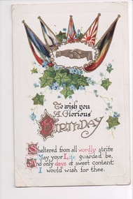 Wangaratta RSL Sub Branch
Postcard, 1917
From the album of WWI soldier William West (1268) of the 29 Infantry Battalion, 5th Pioneers Battalion. This collection of postcards, photographs and clippings were sent between William and his family and loved ones during the years he was on active service. See also 207 and 220. Colour postcard (portrait orientation) with flags of the allies, ivy and flowers above a birthday greeting. Handwritten message on back.Front: "To wish you a glorious birthday / sheltered form all worldly strife / may your life guarded be / and only days of sweet content / i would wish for thee"album, photo album, newspaper clippings, postcard, wwi, 1917, the flags of the allies, belgium, russia, great britain, france, flag, birthday card, birthday, greeting -
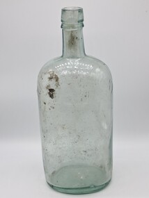 Glenelg Shire Council Cultural Collection
Container - Irish whisky bottle, Mitchell & Co Belfast ltd, c.1890
Spirits came in bottles and were sold at licensed premises.The shape, colour and production methods of the bottles have changed over time. Mitchel & Co. Belfast were established in 1860 in Belfast Ireland.This bottle was received from the ocean floor of the Portland Harbour.Clear heavy glass bottle with green tinge and heavy embossing, manufactured for Old Irish Whisky. The bottle is an oblong shape with long straight sides, three quarters of the way up the sides taper to the neck which has a lip and then the opening. The base of the bottle is curved inwards. Front top: OLD IRISH WHISKY TRADE (INSERT LOGO) MARK Logo: is a likeness of a imperial crown inside a square based shape that comes to a point at the bottom similar to a heat tip and steps in both sides up the top to form a small box top. The letters CL are visible in the centre of the crown. Bottom: MITCHELL & CO OF BELFAST LTD Rear Top: IMPERIAL QUART in a banner old irish whisky, mitchell & co. belfast ltd, bottle, port of portland -
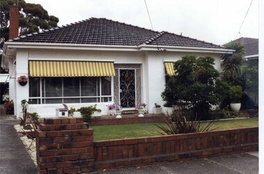 Glen Eira Historical Society
Photograph, Beauville Avenue, 6, Murrumbeena, 2001
Originally labelled "Beauville Estate, Established 1936, Still Thriving 65 years on, 10th March 2001", the Beauville Estate Album contains colour photographs of houses in the Estate. They were taken around the time of the Beauville Estate’s 65th Heritage Celebration held on 10/03/2001 and donated to the Caulfield Historical Society shortly afterwards. Photographer Bev Baxter. City of Glen Eira’s Heritage Management Plan Vol 2 p79 (this is p84 of the pdf version) – HO12 Beauville Estate and environs, Murrumbeena: The Beauville Historic Area is important at the State level as the first large housing estate undertaken by the AV Jennings Construction Co, later Jennings Group Limited, Victoria’s largest home builder. It is important also as a very early estate development incorporating a range of features other than houses and including made roads, shops and recreation facilities. In this respect it was the forerunner of the comprehensively planned housing estate of the post war era. The estate is distinguished by its aesthetic values, as is the earlier and comparable Hillcrest Estate, which are formed by a combination of restrained diversity in house styles, with the exception of no. 30 in the emerging International style, and by a landscaped garden environment. Colour photograph of a white rendered house with striped yellow and white window awnings. Other features include a tiled roof, a cast iron work front porch door, garden urns in front of the house and a low unpainted brick fence in the foreground with a car in its garage down the drive to the left. The garden beds are also supported by walls of the same unpainted bricks with plants including a palm and succulents.murrumbeena, houses, beauville avenue, architectural styles, 1930's, inter war style, a.v. jennings, av jennings, jennings, brick houses, beauville estate, porches, sir albert victor jennings, a v jennings construction co, beauville estate heritage area, glen eira city council, architectural features, jennings group limited, land subdivision, gardens, beauville historic area, cast iron work gates, striped awnings, outdoor ornaments, brick fences, drives, cars, garages (private), palm trees, brick chimneys