Showing 28534 items
matching street street
-
 Bendigo Historical Society Inc.
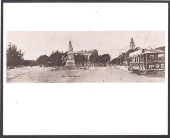
Photograph - JOHN JONES COLLECTION: GOLD MONUMENT
... general street views... to the Black Swan Hotel in McCrae Street. Street surface looks like... Inc. History House 11 Mackenzie Street Bendigo goldfields ...Photo with a brown tinge of the Gold Monument next to the Black Swan Hotel in McCrae Street. Street surface looks like gravel. There are horse drawn vehicles in the picture and on the right side of the photo is a tram with No. 6 painted on the back. Behind the statue is a poppet leg structure and a row of trees around the Hotel.bendigo, streetscape, general street views, john jones collection - gold monument, black swan hotel -
 Eltham District Historical Society Inc
Photograph, Old Bridge, Kaylock's Crossing, Brougham Street, Eltham, c.1895
... Old Bridge, Kaylock's Crossing, Brougham Street, Eltham...brougham street...Brougham Street was created in Josiah Holloway's 1851... melbourne Brougham Street was created in Josiah Holloway's 1851 ...Brougham Street was created in Josiah Holloway's 1851 subdivision of Little Eltham. It was one of several east-west streets shown on the subdivision plan as crossing the Diamond Creek. The western part was named Wellington Street on the subdivision plan but was later changed to conform with the name of the eastern part as acknowledgement of the continuity of the street. It is not known when the first bridge was constructed in Brougham Street however it was certainly mentioned at Council’s meeting of 2 June 1884 as being in a dangerous state of repair. This photo (c.1895) of an old bridge shows a very low-level simple log girder bridge crossing the creek at a right angle and so the approaches involved bends in the road alignment. This bridge was generally known as Kaylocks Bridge or Kaylock’s Crossing after the owner of the adjoining land. It was most likely built from around the mid-1850s, or a crossing of some fashion established as Richard George Kaylock, butcher of Little Eltham and his wife Emily Ann settled there in 1854. His property was in Wellington Street (now Brougham Street) and apparently extended across the Diamond Creek. The land on the western side of the creek was farmed, the house being on the eastern side. Kaylock's Bridge formed part of the original coach road to Eltham and in 1922 was described as an "old rustic bridge". Its low level and insubstantial construction made it susceptible to flood damage, necessitating frequent closures until repairs could be carried out. In September 1922, Council called for tenders for a new timber bridge to be constructed at Kaylock’s crossing. An engineering assessment carried out for the Council by Macleod Consulting at the time of the replacement suggested that the construction details indicate that it was in the 1900s, however this dating could possibly have been the result of numerous repairs undertaken over the years to flood damage. The tender was awarded to Mr Weller of Kangaroo Ground who commenced work in February 1923 on a higher-level timber trestle bridge. Work was slowed due to illness of the contractor and the accidental death of a man in March 1923 following the collapse of the bank after he had jumped into a hole that had just been blasted. The bridge was completed around July 1923 at which point the old structure was pulled up, marking what was described in the ‘Advertiser’ newspaper as the passing of an old and well-loved landmark in the district. In April 1924 the approach to Kaylocks bridge was washed away during the heavy flooding that destroyed the Main Road bridge. The western side was repaired, and an extra span was added to the eastern side using timber from the destroyed Main Road bridge. The bridge was again severely damaged four months later in August 1924 When a lack of finances delayed repairs to the Bridge Street bridge in 1931 (also referred to as Obelisk Bridge at the time), traffic had to detour via Brougham Street for some time. Local residents feared that the Bridge Street bridge might never reopen. Kaylocks Bridge was constantly subject to damage by floods. In the 1934 flood it was submerged by two feet of water. In more recent times the bridge was again severely damaged by flooding and repairs made. A new bridge and adjoining footbridge were constructed in 2009. Part of a slide show presentation "Bridges & Waterways of the Shire" by Russell Yeoman to the 13 September 1989 Society meeting. The presentation included slides of historic photos from the Shire of Eltham Pioneers collections as well as several recent views.Photo of earliest known crossing of the Diamond Creek at brougham StreetPostcard photo printbrougham street, eltham, wellington street, kaylocks bridge, bridge, diamond creek (creek) -
 Ringwood and District Historical Society
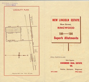
Document - Folder, Land Sale Brochure, New Lincoln Estate, Ringwood, Vic. - circa 1960. Also 1951 newspaper advertisement
... - New Lincoln Estate, New Street, Ringwood, with summary..., Heywood Streets and Sylvia Grove in South-West Ringwood..., Heywood Streets and Sylvia Grove in South-West Ringwood ...Bi-fold advertisement for sale of residential allotments - New Lincoln Estate, New Street, Ringwood, with summary of local facilities and services, locality plan, layout of sub-division, and price list. Also an advertisement from Ringwood Mail dated 12 July 1951. Subdivision includes New Street, Heywood Street, Barkly Street, Keith Grove, Maurice Avenue, Inez Avenue, Catherine Street, Neville Street, Neale Grove (later Heather Grove), and Sylvia Grove. Agent - Ringwood Real Estate Co., Station Entrance, Ringwood. (Phone) WU 6661, WU 6662.Accompanying handwritten sales notes researched in 2024 by Richard Carter - Carter Real Estate ... "Maurice Ashkanasy KC CMG owned the rectangular estate located between New, Barkly, Heywood Streets and Sylvia Grove in South-West Ringwood. It was given the name "The New Lincoln Estate". It was first advertised around July 1951 as "48 superb allotments", through Ringwood Real Estate (Station Entrance). A sub-divisional plan from CE Carter showed 152 blocks with 60-foot frontages and varying between 110 and 150 feet in length. Later, in 1954 house and land packages were offered through William White in Elsternwick - "Three modern bedrooms, large lounge-dining-room, kitchen with dinette, nicely equipped bathroom - £2,685 to £2,762, deposit £300". The roads were created and named after family members - Neale (later Heather) Grove - after Maurice's son Neal Mark Ashkanasy. The street was later re-named Heather Grove after Maurice's wife, Heather Helen Ashkanasy (Epstein), who passed away in 1999, aged 95. Neville Street - after Marice's other son, Aaron Solomon Neville Ashkanasy known as Neville. Catherine Street and Inez Street - after Heather's mother Catherine Inez Epstein. Maurice Avenue - after Maurice Ashkanasy, vendor. Keith Grove - after Keith Epstein. ..." -
 Glenelg Shire Council Cultural Collection
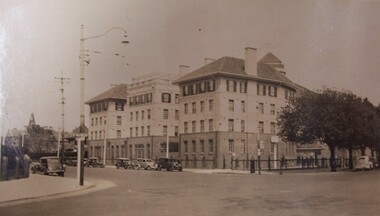
Photograph - Photograph - St Kilda Road, Melbourne, Esther Winifred Hall, 1934
... at street intersection. Street sign on left "St. Kilda Rd".... Cliff Street Portland great-ocean-road Photographs taken ...Photographs taken by Esther Winifred Hall (nee Smallpage) - great grand-daughter of Stephen George Henty. Taken in 1934 Centenary Celebrations in Portland.Black and white sepia photograph of four-storey building at street intersection. Street sign on left "St. Kilda Rd".Front: (no inscriptions) Back: Chevron corner St. Kilda and Commercial Roads Nov: 1934 V. Hursthouse (?)esther winifred hall, henty, 1934 -
 Ringwood and District Historical Society
Map, Two Partially Trimmed Copies of Ringwood Township Estate subdivision advertisement - 1919
... on numbered allotments in Ellison Street, Haig Street and Wantirna.... Handwritten sales notations on numbered allotments in Ellison Street ...Clippings on cardboard backing. Handwritten sales notations on numbered allotments in Ellison Street, Haig Street and Wantirna Road, Ringwood.One copy includes three oval rubber stamp impressions - F. Parker, Estate Agent, Ringwood. -
 Ringwood and District Historical Society
Pamphlet, Land Sale Brochure Titled Eureka Plan Book - Seven Delightful & Valuable Ringwood Estates - circa 1925
... of Ringwood School Estate includes William Street (later Kendall... William Street (later Kendall Street), Greenwood Avenue, Alton ...Twenty page land sale brochure including photographs, subdivision features and local facilities. Additional flyer with conditions of sale and prices for estate blocks.Seven delightful and valuable Ringwood Estates called Bestpart, Paradise, Hill Top, Greenwood, Creek, Station, and School Estates. These nestle amidst the hills and valleys of beautiful Ringwood district. Also Goodluck Estate at Clarinda. Pamphlet marked as being From Mr. Farmer, No. 5 Flinders Court, Melbourne. Phone 988, 989 Central, or 55 Ringwood after 7 p.m. Plan of Ringwood School Estate includes William Street (later Kendall Street), Greenwood Avenue, Alton Street and Locke Street. Plan of Bestpart Estate, Ringwood, includes Bedford Road, Wilana Street, Greenwood Avenue, Caroline Street, Henry Street and Haig Street. Plan of Ringwood Station Estate includes Pitt Street, Bedford Road, Greenwood Avenue, Station Street, William Street (later Kendall Street, James Street, Wantirna Road, Caroline Street, Henry Street, Ellison Street and Haig Street. Plan of Geenwood Estate, Ringwood, includes Prussian Road (later Geenwood Avenue). Plan of Paradise Estate, Ringwood, includes Canterbury Road, Dandenong Road (Wantirna Road), Luck Street and Paradise Road. Plan of Creek Estate, Ringwood, includes Dandenong Creek, Wantirna Road and Gordon Crescent. Plan of Hill Top Estate, Ringwood (later Heathmont area), includes Heathmont Railway Station, Heathmont Road, Balfour Avenue, Lilian Street, Edith Street, Edna Street and Great Ryrie Street. Plan of Goodluck Estate, Clarinda, includes Talbot Avenue, Good Street, Luck Street, and Centre Road in locality plan between Oakleigh and Clayton Railway Stations. -
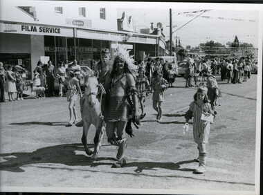 Clunes Museum
Photograph
... BLACK AND WHITE PHOTOGRAPH STREET PARADE, FRASER STREET...Clunes Museum 36 Fraser Street Clunes goldfields local ...BLACK AND WHITE PHOTOGRAPH STREET PARADE, FRASER STREET, CLUNESlocal history, photography, photographs, events and celebrations -
 Port Melbourne Historical & Preservation Society
Document - Photocopy, maps, 1890s maps, 30 April 1890 .01 11 March 1890 .02
... to Esplanade East; to Graham Street; to Boundary Road & Pickles Street... Melbourne Town Hall 333 Bay Street Port Melbourne melbourne Built ....01 Copy of Map 3084B - Port Melbourne, Willamstown Road to Esplanade East; to Graham Street; to Boundary Road & Pickles Street. .02 Copy of map of Port Melbourne, Bay Street to Clark Street; to Foreshore; to Pickle Street & Spring Street..01 for title information see parcels index 47,53,54,55,56 & 57. .02 Parcels index 3084-B 16 (City of Port Melbourne)built environment - commercial, built environment - domestic, city of port melbourne, parish of south melbourne -
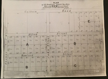 Kew Historical Society Inc
Plan - Subdivision Plan, Plan of 68 beautifully situated villa sites: St Helliers Kew, 196-1973
... in a subdivision bordered by Cotham Road; Edward Street; Sackville Street... Road; Edward Street; Sackville Street and Thomas Street ...This work forms part of the collection assembled by the historian Dorothy Rogers, that was donated to the Kew Historical Society by her son John Rogers in 2015. The manuscripts, photographs, maps, and documents were sourced by her from both family and local collections or produced as references for her print publications. Many were directly used by Rogers in writing ‘Lovely Old Homes of Kew’ (1961) and 'A History of Kew' (1973), or the numerous articles on local history that she produced for suburban newspapers. Most of the photographs in the collection include detailed annotations in her hand. The Rogers Collection provides a comprehensive insight into the working habits of a historian in the 1960s and 1970s. Together it forms the largest privately-donated collection within the archives of the Kew Historical Society.A photographic reproduction of a plan in the Vale Collection of the State Library of Victoria. The plan shows lots in a subdivision bordered by Cotham Road; Edward Street; Sackville Street and Thomas Street. The undated plan does not include the land occupied by Bella Vista and Charleville.subdivision plans -- kew (vic), st helliers estate -
 Bacchus Marsh & District Historical Society
Map, Plan of the property of Messers Atkins and Clarke to be sold at the Mansion, Bacchus Marsh 19th April 1856. Copy 1
... portions. The land for sale is bounded by the present day streets... portions. The land for sale is bounded by the present day streets ...This plan of land allotments for sale indicates the property once owned by the Bacchus family in and around the township area of Bacchus Marsh. The Bacchus family sold their property in Bacchus Marsh to John Atkins and Robert Nalder Clarke in March 1851. Atkins and Clarke kept the property for a number of years until April 1856 when these allotments were put up for sale.This plan is almost identical to another copy held by the Bacchus Marsh and District Historical Society, VC Record 452, BMDHS collection). This plan, VC Record 707 Copy 1, contains a little more detail overall than VC Record 452 Copy 2, such as who did the survey work for the plan (R.C. Bagot) and who the selling agents were, (W.M. Tennent), and on the right side of the plan near the Lerderderg River is indicated the general area for a second parcel of land from this sale which is to be sold. There is also a compass illustration indicating north and south compass points.This is a very early land sales plan for the township of Bacchus Marsh and it therefore provides some clues as to how the early urban development of the township took place. Upon seeing the map in 1911 Bacchus Marsh Express newspaper editor Christopher Crisp wrote "The sale appears to have created the present township, which had a nucleus in earlier times further east", Express, 30 September, 1911, page 3.A single page paper plan showing allotments of land for sale. The subdivided land shown was owned by John Atkins and Robert Nalder Clarke, but previously owned by the Bacchus Family and was in and around their Manor House (Mansion) property in Bacchus Marsh.There are 5 portions of land further divided into numerous small portions. The land for sale is bounded by the present day streets of Main Street, Young Street, McFarland Street, Morton Streets, Crook Street, and part of the eastern section extends to the Lerderderg River. Scale: 8 chains to 1 inch The plan is pasted into a bound volume containing 76 maps or plans in total. BMDHS Loc: AR/B12/S4 Bacchus Marsh Township and Nearby Districts Maps Volume In-house Digital copies: BMDHS, Computer Network: Maps\Bacchus Marsh Township and Nearby Districts Maps VolumeHeading: Plan of the first portion of land. The property of Messers Atkins and Clarke situate at Bacchus Marsh. To be sold by W.M. Tennent & Co. at the Mansion on the Ground on Saturday the 19th April 1856. Below heading: Jas Ferguson, Lithographer On upper right side: Subdivided by R.C. Bagot London and Liverpool Chambers, Melbourne. 'Thos Taubman'. Post Office Stamp: BACCHUS MARSH VICTORIA MY 6, 63bacchus marsh victoria maps, bacchus family, land sales, manor house bacchus marsh -
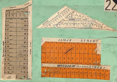 Ringwood and District Historical Society
Card, Subdivision Maps - Ringwood, Victoria - (Undated, circa 1920s)
... , Station Street, James Street, Bedford Road, Williams Grove (later..., Station Street, James Street, Bedford Road, Williams Grove (later ...Collage of three residential allotment maps on green cardboard backing.Subdivisions include West Prussia Road, Wantirna Road, Station Street, James Street, Bedford Road, Williams Grove (later Lena Grove), and William Street (later Kendall Street), Ringwood. -
 Bacchus Marsh & District Historical Society
Map, Village allotments, Parish of Myrniong, County of Bourke
... map created in 1861. The early layout of streets... map created in 1861. The early layout of streets ...Myrniong is a village 9 kilometers west of Bacchus Marsh. Prior to 1863 the area was known as Blow's Flat. This map which was produced in 1903 and according to the catalogue record of this map held at the State Library of Victoria was based on an earlier map created in 1861. The early layout of streets for the village of Myrniong can be seen on this map. The streets shown are, Main Street, Hardy Street, Blow Street, Myrniong Street, Shuter Street, and Blackwood Street. An area marked as a reserve for a school can be seen between Hardy Street and Main Street.A single page paper map. A cadastral parish map of Myrniong in Victoria, showing numbered land allotments. Photo-lithographed at the Department of Lands & Survey, Melbourne, in 1903. Based on an original map created in 1861. The map is pasted into a bound volume containing 76 maps or plans in total. High resolution digital image stored on BMDHS computer network. Surveyed by John Hardy, Surveyor ; photo-lithographed at the Department of Lands & Survey, Melbourne by T.F. McGauran, 24.12.03myrniong parish plan, myrniong parish maps -
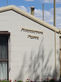 Ballarat Heritage Services
Photograph, Fernleigh Flats, Ballarat, 12/02/2022
... House, corner of Urquhart and Ripon Streets. Apply Owen Cazaly...A retirement village on the corner of Urquhart Street.... "TO LET, a Brick House, corner of Urquhart and Ripon Streets ...Residents of the Fernleigh Flats Retirement village are understood to be well and strong enough to care for themselves and need to be over the age of 55 years. Fernleigh Flats is owned and operated by the Seventh Day Adventist Church. "TO LET, a Brick House, corner of Urquhart and Ripon Streets. Apply Owen Cazaly, Mining Exchange."(Ballarat Star, 16 Aug 1867) "SALE BY AUCTION, Corner of Urquhart and Ripon streets, 07 COMFORTABLE COTTAGE PROPERTY. M'GREGOR BROTHERS, instructed by the owner, Mr Bradbury, who has bought another property, will sell by public auction, on Monday, 16th May, at half-past 12, His six-roomed substantially-built RESIDENCE. The owner has, under his own supervision, spared no expense in making this a most comfortable and convenient dwelling, situated on a quarter of an acre allotment, at the corner of Urqhuart and Ripon streets, high and dry. Garden laid out with choice young fruit trees; ground capable of growing anything. Fowl yard fenced off. making It a most desirable residence. For a family residence or as An investment this is a good opportunity. Inspection invited. Auctioneer, R. M'GREGOR. (Ballarat Star, 12 May 1893.)A retirement village on the corner of Urquhart Street and Ripon Street, Ballarat. The street trees surrounding this property include a number of trees (blue cedar?) and suggest the demolition of an older stately home on this site. fernleigh flats, residences, architecture -
 Federation University Historical Collection
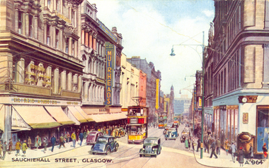
Postcard - colour, Sauchiehall Street, Glasgow
... Sauchiehall Street, Glasgow...auchiehall Street /ˈsʌxihɔːl/ is one of the main shopping...Colour postcard of a street with cars, double decker buses...Sauchiehall Street, Glasgow, Scotland... auchiehall Street /ˈsʌxihɔːl/ is one of the main shopping/business ...auchiehall Street /ˈsʌxihɔːl/ is one of the main shopping/business streets in the city centre of Glasgow, Scotland. Along with Buchanan Street and Argyle Street, it forms the main shopping area of Glasgow, containing the majority of Glasgow's high street and chain stores.[1] Although commonly associated with the city centre, Sauchiehall street is over 11⁄2 miles (2.5 km) long, finally meeting Argyle Street in the West End, in front of the Kelvingrove Museum, where they form Dumbarton Road which continues through Partick. The two streets run parallel through the city centre, before starting to conjoin westward of the M8 motorway at Charing Cross. (Wikipedia)Colour postcard of a street with cars, double decker buses and four storey buildings. The street is Sauchiehall Street, Glasgow, Scotland.chatham-holmes family collection, glasgow, scotland, double decker bus -
 Kilmore Historical Society
Photograph, Heather Knight, Brewery Hill, Cnr Sydney & Clarke Street, 2002
... Brewery Hill, Cnr Sydney & Clarke Street... of Sydney Street and Clarke Street. It shows Brisbane Street...Kilmore Historical Society 4 Powlett Street Kilmore ...15cm x 10cm coloured photograph of Brewery Hill, corner of Sydney Street and Clarke Street. It shows Brisbane Street. There is a car traveling up Brisbane Street.Written on the back: Brewery Hill, cnr Sydney St + Clarke Showing Brisbane St on left Photo: Heather Knight Feb 2002 -
 Ringwood and District Historical Society
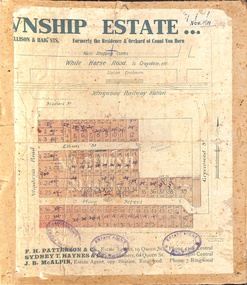
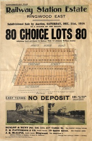
Flyer, Subdivisional Auction Sale Brochure, Railway Station Estate, Ringwood East, Vic. - 1918
... shown as White Horse Road), Dublin Road, Freeman Street, Bona..., Freeman Street, Bona Street, and Patterson Street. Local Agent ...Advertisement for subdivisional auction sale of 80 residential allotments on Saturday, 21st December, 1918, including terms of sale, subdivision layout, and nearby location photographs.Subdivision includes Mount Dandenong Road (incorrectly shown as White Horse Road), Dublin Road, Freeman Street, Bona Street, and Patterson Street. Local Agent - J.B. McAlpin, Telephone Ringwood 7. -
Federation University Historical Collection
Photograph, Ballarat State Offices, 1980s
... Ballarat State Offices on the corner of Mair Street... glass house Ballarat State Offices on the corner of Mair Street ...This building is known locally as the glass houseBallarat State Offices on the corner of Mair Street and Doveton Street North.ballarat state offices, glass house -
 Bendigo Historical Society Inc.
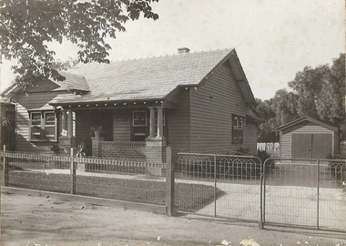
Photograph - T C WATTS & SON COLLECTION: MERCY STREET, BENDIGO, 1930
... T C WATTS & SON COLLECTION: MERCY STREET, BENDIGO.../AUCTIONEER/ESTATE AGENTS/253 MITCHELL STREET/BENDIGO''... ' King's, Mercy Street Street £1000'.... Inc. History House 11 Mackenzie Street Bendigo goldfields BHS ...BHS CollectionBlack and white photograph mounted on rectangular brown board. House, weatherboard, tile roof, 2 chimneys, woven crinkled wire fence, 4 gates, leadlight windows, weatherboard garage RH side of house, washing on line at back, porch with brick balustrade and concrete pillars. On back of photoboard ' King's, Mercy Street Street £1000'.Frank A. Jeffree, Bendigoplace, building, residential, stamped on back in rectangle ''t.c. watts and son/auctioneer/estate agents/253 mitchell street/bendigo'', stamped on back in circle ''royal historical society of victoria, bendigo branch'', handwritten on back ''kings/mercy street/1000pounds'' -
 City of Kingston
Pamphlet - Colour, Brock Bros, South Brighton Township Estate, 1888
... Street and the Mordialloc Railway Line. Incorporates Wolsely... Street, and the Mordialloc Railway Line. Includes Wolsley Street... Street and the Mordialloc Railway Line. Incorporates Wolsely ...Sales plan for land in the suburb of South Brighton (Moorabbin), bounded by Point Nepean Road, South Road, Patterson Street and the Mordialloc Railway Line. Incorporates Wolsely Street and Gordon StreetThe developing urban area of Moorabbin within the City of Kingston. This land sale pamphlet illustrates the subdivision of land within the municipality and the changing demographic of the district as new houses are constructed close to infrastructure.Colour pamphlet advertising for private sale the South Brighton Township Estate, South Brighton. Incorporates a map of the estate bordered by Point Nepean Road, South Road, Patterson Street, and the Mordialloc Railway Line. Includes Wolsley Street and Gordon Street. land sales, south brighton, estate, moorabbin -
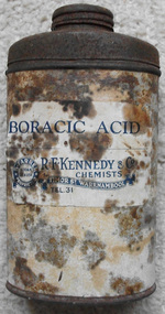 Warrnambool and District Historical Society Inc.
Container - Boracic Acid Tin: Kennedy Chemist, Early 20th century
... chemist timor street warrnambool... and early 20th century in Timor Street Warrnambool. Mr Kennedy... Street (south of Merri St) Warrnambool great-ocean-road R. F ...R. F. Kennedy operated as a pharmacy in the late 19th and early 20th century in Timor Street Warrnambool. Mr Kennedy manufactured a large number of drugs and perfumes on a wholesale basis as well as very impressive retail business. Around the mid 1880’s they were shipping 5000 dozen bottles of Janos salts annually. Boracic acid was one such product which was commonly used product as an insecticide, herbicide and in cleaning products.A common item which was manufactured by one of the largest manufacturing chemists of the area. R. F. Kennedy was a significant business in Warrnambool.Oval shaped tin with cream paper label overlaid with blue and white label. All labels are stained brown.R.F Kennedy & Co Chemists Timor St Warrnambool, Tel, 31. B Farrer proprietor Kodak dealer. warrnambool, r. f. kennedy, chemist timor street warrnambool, timor street warrnambool, chemist -
 Eltham District Historical Society Inc
Photograph, Fay Bridge, United Service Station, Main Road, Eltham, 26 August 2019
... Diamond Street... melbourne Fay Bridge Collection 2019-08-26 Cockatoos Diamond Street ...fay bridge collection, 2019-08-26, cockatoos, diamond street, eltham, luck street, main road, united service station -
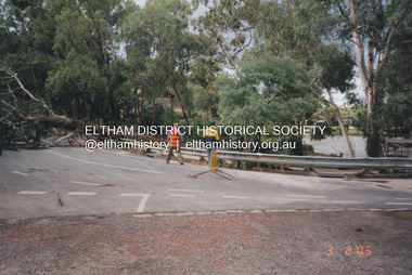 Eltham District Historical Society Inc
Photograph, Fay Bridge, Diamond Creek in flood, Eltham, 3 February 2005
... Bridge Street Bridge... 2005. Fay Bridge Collection Bridge Street Bridge Diamond Creek ...Significant flood events occurred Nov-Dec 2004 and Jan-Feb 2005.fay bridge collection, bridge street bridge, diamond creek (creek), floods, floodwater, footbridge, main road bridge, susan street oval, diamond street, eltham -
 Eltham District Historical Society Inc
Album - Photograph Album, J.A. McDonald, Bridge and Road Reconstruction Works, Shire of Eltham, 1952-1962
... Bridge Street Bridge... construction Bridge Street Bridge Bridge Brisbane Street Brougham Steet ...J.A. McDonald produced this record in the course of his responsibilities as Shire Engineer for Eltham Shire Council.Record of various Shire of Eltham infrastructure works undertaken during the period of 1952-1962 involving bridge and road reconstruction projects, sometimes with Eltham Shire Council Project Reference numbers quoted. It was during this period that a number of significant improvements were made to roads and new bridges constructed within the shire that remain in place as of present day (2022). In many situations, the photos provide a tangible visible record of infrastructure that existed throughout the early days of the Shire. The album was put together by or under the direction of the Shire Engineer, J.A. McDonald.a. gillies, alistair knox park, benchmark studies, bend of islands, blease road, box hill state school, box hill teachers college, box hill tip, bridge construction, bridge street bridge, bridge, brisbane street, brougham steet, bulldozer, cecil street, charis pelling, cherry tree road, city of preston, cr. a. brinkkotter, cr. charis pelling, cranes, cromwell street, diamond creek (creek), diamond street, dixons creek bridge, dixon's creek road, drott, eltham leisure centre, eltham north, eltham police station, eltham, eltham-yarra glen road, f. wood, fitzsimons lane bridge, flat rock road, flood damage, floods, floodwater, footpaths and gutters, ford service garage, g. blair, garden hill, glen park bridge, glenauburn road, grand hotel, haldane road, healesville, healesville-yarra glen road, heidelberg-kinglake road, henley road bridge, henley road, hill property, hurstbridge water scheme, hurstbridge, hurstbridge-arthurs creek road, infrastructure, j. jolly, kangaroo ground, kangaroo ground-queenstown road, kangaroo ground-st andrews road, lilydale shire office, long gully bridge, long gully creek, long gully road, long gully, lower plenty bridge, lower plenty footbridge, lower plenty oval, lower plenty road, lower plenty, main road, methodist church, montmorency, mount pleasant road, new holland, old healesville road, opening ceremony, oxley bridge, para road, paul creek bridge, paul creek road, paul krafeznk, pinnacle lane, plaques, plenty river trail, plenty river, presbyterian church, prof donald thomson, pryor street, railway crossing, railway parade, rattray road, reconstruction works, reichelt avenue, research (vic.), research oval, road construction, rymers corner, shire of eltham, shire of whittlesea, silvan road bridge, silver street bridge, silver street, sir dallas brooks, smedley property, st andrews, steels creek, susan street, tarrawarra, tony carberry, uniting church, upper yarra dam, upper yarra reservoir, w.e. wolf, waterfall property, watsons creek, wattletree road bridge, wattletree road, wattletree road bridge, worlingworth, yarra glen, york street, yow yow creek -
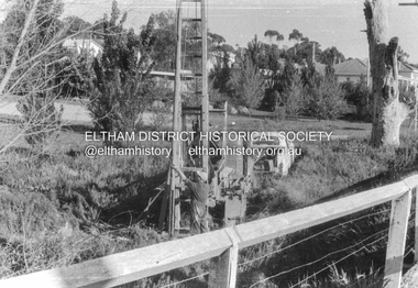 Eltham District Historical Society Inc
Album - Photograph, J.A. McDonald, Cecil Street Bridge, Eltham-Yarra Glen Road, Eltham, Oct. 1962
... Cecil Street Bridge, Eltham-Yarra Glen Road, Eltham...Bible Street Reserve...Eltham-Yarra Glen Road Cecil Street Bridge Looking upstream... melbourne Eltham-Yarra Glen Road Cecil Street Bridge Looking ...Eltham-Yarra Glen Road Cecil Street Bridge Looking upstream Oct. 1962Record of various Shire of Eltham infrastructure works undertaken during the period of 1952-1962 involving bridge and road reconstruction projects, sometimes with Eltham Shire Council Project Reference numbers quoted. It was during this period that a number of significant improvements were made to roads and new bridges constructed within the shire that remain in place as of present day (2022). In many situations, the photos provide a tangible visible record of infrastructure that existed throughout the early days of the Shire. The album was put together by or under the direction of the Shire Engineer, J.A. McDonald.H941 stamped on reverse (film processing #)infrastructure, shire of eltham, bridge construction, road construction, 1962-10, bible street reserve, cecil street bridge, eltham, eltham-yarra glen road, main road -
Glen Eira Historical Society
Document - St. Peter’s Girls’ School
... Dunoon Street Murrumbeena... for Girls Dunoon Street Murrumbeena Dunoon Street Public Hall Laird ...Information about St. Peter’s Girls’ School, Murrumbeena. Includes an extract about the school from the History of St. Peter’s Church Murrumbeena 25th Anniversary, covering years 1917-1948. Also includes extracts relating to the school from Feeding Christ’s Sheep: a History of St. Peter’s Murrumbeena with Holy Nativity Hughesdale by Alex Reid. Includes pictures of the school buildings. Paragraphs relating to the school marked in blue pen.twedell florence, hitchcock isabel, ingham a.e. rev., st. aidan’s school, st. aiden’s church of england school for girls, dunoon street murrumbeena, dunoon street public hall, laird-brown miss, le fevre mrs., king copland, kemp w.a., green w.g.a., sr. laura, andrews eileen, de bibra eric, tucker w.h., potter bill rev., chapple l., baddams miss, shelford, shelford girls’ grammar, beard doris, maydom ross, nicholas g., beeforth janet, bannister kerry, combes deborah, harvey paul rev., durance ruth, cope v., crowther mrs., warne margaret, st. aidan’s school, dunoon street murrumbeena, st. peter’s murrumbeena, st. peter’s girls’ school, fulton lorna, de bibra florence, walker miss, cragg elvie, hoggart mrs., booth miss, andrew miss, de bibra margaret, de bibra peggy, chapple e.t., st. peter’s school, independent schools, anglican church, st. peter’s girls’ grammar school, st. peter’s church of england girls’ grammar school, reid alex, religious structures and establishments -
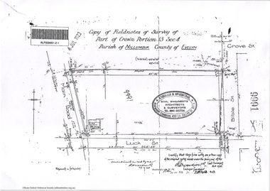 Eltham District Historical Society Inc
Document - Photocopy, Survey Fleld Notes of Part of Crown Portion 13, Section 4 at Eltham, Parish of Nillumbik, County of Evelyn, 7 January 1924
... Bible Street...Portion of land north of Luck Street bounded by: Main Road... melbourne Portion of land north of Luck Street bounded by: Main Road ...Portion of land north of Luck Street bounded by: Main Road, Bible Street Application 9991 R. Woodstock, Land Surveyor, 7 January 1924application 9991, bible street, eltham, luck street, main road, map, survey plan -
 Glen Eira Historical Society
Photograph - NETTALIE
... O’Loughlin Street... Labassa O’Loughlin Street Ormond Hotham Street Melbourne Grammar ...Various documents about and photographs of Nettalie or Netley House or The Nest on Balaclava Road Caulfield now part of Melbourne Grammar School: 1/The first is an article undated and unattributed accessed from Beresford.org on 14/07/2006 detailing with bibliography the history of Netley House including the owners especially the Shaw family. 2/There are several separately colour-printed photographs of the front facade of Nettalie most undated and unattributed, and one family portrait of the Shaw family circa 1863. All were also accessed from Beresford.org on 14/07/2006. 3/One black and white photograph is inscribed '73 Balaclava Rd Caulfield 3/9/72 Neg 16A'. 4/Two copies of a plan of Nettalie next to The Curragh and Harleston, also in the article and likely accessed from same source on same date. 5/A copy of Dr Cameron’s letter to Herbert Shaw dated 24/05/1949. 6/One copy of a letter from Herbert Shaw to Dr William Cameron dated 25/05/1949. 7/A plan of Melbourne Grammar School with each building dated to when it was built including Netley House in 1863.shaw herbert, shaw alfred henry, shaw arthur, shaw amelia, shaw lavinia, forsyth william, blundell mary, fosbery john, bakewell john, hailes george b, blundell miss, stephen george sir, billings richard, ware martha, desailly alfred, cameron william dr, cameron j mrs, nettalie, the nest, netley house, house names, caulfield north, balaclava road, grimwade house, orrong road, harleston, caulfield road district, st kilda east, the curragh, shelford, helenslea, sylliot hall, labassa, o’loughlin street, ormond, hotham street, melbourne grammar school, caulfield conservation study, mansions, teachers, schools, independent schools, hardware stores, business people, lawyers, businesses, brick houses, outbuildings, architectural styles, classrooms, bunya bunya pine trees, trees, orchards, land subdivisions, land sales, doctors -
Glen Eira Historical Society
Article - Athole, Poplar Grove, 18, Carnegie
... Edgewood Street... Street Brick houses Glen Huntly Road Glenhuntly Road J R Buxton ...Two items about this property: 1/Pages 17 and 18 of the Real Estate section of the Caulfield Southern Cross 29/07/1992 including an article on Athole, Poplar Grove, 18, Carnegie, with a sketch of the house and a detained architectural description about its historic features. It also gives a brief history of the house and the life of its designer and owner, architect John T. Kelleher. Names and contact numbers of the Real Estate auctioneers are provided and there are a number of advertisements for other houses in Glen Eira. 2/A photocopy of 2 colour photographs of the exterior and garden of 'Athole' circa 2012.carnegie, poplar grove, athole, kelleher john t, biggin and scott, auctions, stables, stockdale and leggo, glen huntly, wattle avenue, munro avenue, edgewood street, brick houses, glen huntly road, glenhuntly road, j r buxton, caulfield south, pyne street, elsternwick, stanley street, noel jones and associates, brukarz jack, fitch karl, moonya road, wattle avenue, mcpherson street, timber houses, caulfield north, aroona road, dunbar avenue, urandaline grove, lascelles street, mclaurin road, trevelyan street -
 Eltham District Historical Society Inc
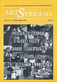
Journal, Peter Doughtery, ArtStreams: Arts & Culture in Banyule, Darebin, Manningham, Nillumbik and Whittlesea; Vol. 5, No. 1, Mar-Apr 2000, 2000
... were street cafe... centre were street cafe Were Street hill climb bahnhof cafe ...Vol. 5, No. 1, Mar-Apr 2000 CONTENTS ON THE ROAD The Car at Heide 3 ON TOP OF THE WORLD Dandenong Ranges Folk Festival 5 INTERVIEW Felicity Gordon 7 SOUNDS OF HARMONY Gyuto Monks in Eltham 10 BANYULE FESTIVAL 13 WERE ST HILL CLIMB 15 BOROONDARA WRITERS' FESTIVAL 16 WARRANDYTE VILLAGE FESTIVAL 18 DIAMOND CREEK TOWN FAIR 19 TEMPLESTOWE VILLAGE FESTIVAL 20 RECIPES From leading Chefs 21 CAIRO TO CRACOW Middle Eastern Music at Montsalvat 22 POETRY 23 FESTIVAL OF KITES 24 BOOK REVIEW By Michele Lonsdale 25 CD REVIEWS 27 ARTIN ABOUT 28 WINING & DINING 30 ARTISTS SERVICES 32 "Peter Dougherty has been involved in the local art scene for many years. As publisher and editor of the arts magazine Artstreams, his comments on the various branches of the arts are widely respected. His "The Arts" column in the Diamond Valley Leader presents a brief summary for a much wider cross section of the local community. Peter also operates his own gallery and the Artstreams Cafe at the St Andrews market. Peter has a wealth of knowledge about present day and historical aspects of local art and artists." - Eltham District Historical Society Newsletter No. 161, March 2005Colour front and back cover with feature articles and literary pieces with photographs and advertisements printed in black and white. 36 pages, 30 cm. Vol. 1, no. 1 (Nov. 1996) - Vol. 10, no. 5 (summer ed. 2005/06) art streams, carly young, plenty views golf park, dynamic vegies, dandenong ranges folk festival, felicity gordon, sounds of global harmony, banyule festival, rosanna fire station community house, bulleen art & garden centre, were street cafe, were street hill climb, bahnhof cafe, walkers wheels, peter glass, eltham wiregrass gallery, boroondara writers festival, warrandyte festival, diamond creek town fair, templestowe village festival, willy wonkas ice cream, gourmet food, ciaro to cracow, fleur de feliss florist, mia mia gallery, festival of kites, bi-wize quality paints, kinglake gallery, andy cowan, wild dog hill studio, montsalvalt, ian collard, geoff achison, bridget allen, thompsons pharmacy, volumes -
 Eltham District Historical Society Inc
Slide - Photograph, John Street, Eltham, c.Jun. 1986
... John Street, Eltham...bible street... melbourne bible street eltham john street roads infrastructure ...35mm colour positive transparency (1 of 7) Mount - Kodak Kodachrome CardProcess Date JUN 86Mbible street, eltham, john street, roads, infrastructure