Showing 32357 items matching "building"
-
 Eltham District Historical Society Inc
Photograph, The former Police residence at 728 Main Road under renovation work for future Shire of Eltham use, c.Nov. 1991
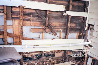
The original Eltham Police Station was used up till about 1960. The building was then taken over and used by the Vermin and Noxious weeds Destruction Section of the Department of Crown Lands and Survey. They vacated the building c.March 1981 and it remained unoccupied for a period of time whilst its future was discussed in Council. About 1986 the Shire took over use of the Police Residence and renovated it for use by the Shire Parks and Environment Office. The original Police Station was termite infested and was removed. It was later replaced by a replica building which was used as a lunchroom for Council employees working at the site. Based on photos contained in the 1992 Bick Heritage Study of the Police Residence and Stable, this roll of film was taken Nov 1991.Roll of 35mm colour negative film, 7 stripsKodak GA 100 5095shire of eltham, justice precinct, police residence, police station, local history centre -
 Eltham District Historical Society Inc
Photograph, The former Police residence at 728 Main Road under renovation work for future Shire of Eltham use, c.Nov. 1991
The original Eltham Police Station was used up till about 1960. The building was then taken over and used by the Vermin and Noxious weeds Destruction Section of the Department of Crown Lands and Survey. They vacated the building c.March 1981 and it remained unoccupied for a period of time whilst its future was discussed in Council. About 1986 the Shire took over use of the Police Residence and renovated it for use by the Shire Parks and Environment Office. The original Police Station was termite infested and was removed. It was later replaced by a replica building which was used as a lunchroom for Council employees working at the site. Based on photos contained in the 1992 Bick Heritage Study of the Police Residence and Stable, this roll of film was taken Nov 1991.Roll of 35mm colour negative film, 7 stripsKodak GA 100 5095shire of eltham, justice precinct, police residence, police station, local history centre -
 Eltham District Historical Society Inc
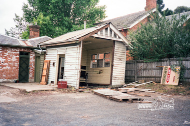
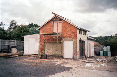
Photograph, The original Police Stables at 728 Main Road under renovation work for future Shire of Eltham use, c.Nov. 1991
The original Eltham Police Station was used up till about 1960. The building was then taken over and used by the Vermin and Noxious weeds Destruction Section of the Department of Crown Lands and Survey. They vacated the building c.March 1981 and it remained unoccupied for a period of time whilst its future was discussed in Council. About 1986 the Shire took over use of the Police Residence and renovated it for use by the Shire Parks and Environment Office. The original Police Station was termite infested and was removed. It was later replaced by a replica building which was used as a lunchroom for Council employees working at the site. Based on photos contained in the 1992 Bick Heritage Study of the Police Residence and Stable, this roll of film was taken Nov 1991.Roll of 35mm colour negative film, 7 stripsKodak GA 100 5095shire of eltham, justice precinct, police residence, police station, local history centre -
 Eltham District Historical Society Inc
Photograph, The original Police Stables at 728 Main Road under renovation work for future Shire of Eltham use, c.Nov. 1991
The original Eltham Police Station was used up till about 1960. The building was then taken over and used by the Vermin and Noxious weeds Destruction Section of the Department of Crown Lands and Survey. They vacated the building c.March 1981 and it remained unoccupied for a period of time whilst its future was discussed in Council. About 1986 the Shire took over use of the Police Residence and renovated it for use by the Shire Parks and Environment Office. The original Police Station was termite infested and was removed. It was later replaced by a replica building which was used as a lunchroom for Council employees working at the site. Based on photos contained in the 1992 Bick Heritage Study of the Police Residence and Stable, this roll of film was taken Nov 1991.Roll of 35mm colour negative film, 7 stripsKodak GA 100 5095shire of eltham, justice precinct, police residence, police station, local history centre -
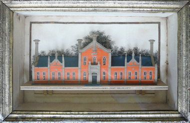 Creswick Museum
Model Building, circa 1869
Rev. Thomas Williams was grandfather of the Lindsay children. He is credited with encouraging his grandchildren in their artistic talents. Both Lionel and Normam learnt their model making skills from him. Creswick Hospital was foundation stone was laid in 1863. It operated as a hospital until 1911 when it was sold to the government as part of the School of Forestry (now University of Melbourne). The model shows it as a red brick building. In the 1870s it was painted as a white building. The Museum has b/w photos of the building taken prior to rendering. The people of Creswick collected fund for the project and obtained a government grant. The 1857 survey map of the proposed township shows the area at Eastern Hills reserved for a hospital and Benevolent SocietyThe model's unique association with the Lindsay Artist of Creswick. Model of Creswick Hospital before rendering. Made of paper with painted background and framed.model, creswick hospital, rev t. williams, lindsay family -
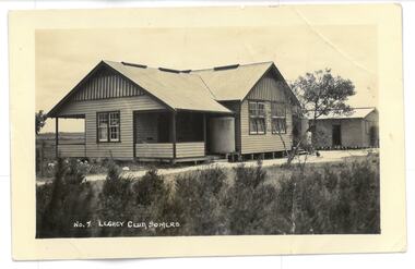 Melbourne Legacy
Photograph, Legacy Club, Somers
Photograph of a building on Legatee Stan Savige's property. It is labelled as Legacy Camp, Somers. This appears to be the original camp buildings established by Legacy in the 1930s. Melbourne Legacy provides camps for junior legatees. The camps gave the children an opportunity of a summer beach holiday with other Legacy children. It started with outings to the property of Legacy founder, Legatee Stan Savige, who had a place in Balnarring East, close to the beach. Permanent camp buildings were built in 1930. In 1930 Lord Somers (Governor of Victoria) also started a camp at a nearby property and the area was renamed Somers. Legacy Somers Camps continued intermittently at Stan's property until it was decided in 1951 to make other arrangements for holidays. An original building at Somers Camp.Black and white photo of No. 7 Legacy Club Somers and white envelope.00398.1 Photo. "No. 7 Legacy Club Somers" on front. POST CARD in black ink on reverse. Pencil "To Ey?? / Legacy Camp / Bonnie" in pencil on reverse. 00398.2 Envelope. Archives June 1995. Legacy Camp. Legacy on Parade" in blue pen. "L/G D. Simonson" in black penjunior legatee outing, savige property, legacy somers camp, camps -
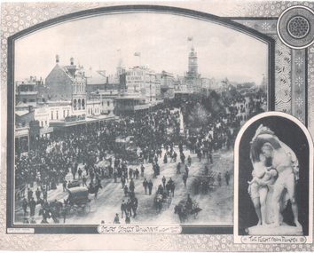 Ballarat Tramway Museum
Photograph - Illustration, F W Niven & Co, "Sturt Street Ballarat on eight hours day", 1890s
The photo shows a large crowd on an 8 hours (Labour Day) gathered in the eastern end or lower end of Sturt St. The 8-hour memorial or monument is in the centre of the photograph. Has one double-deck horse tram in view along with many other horse-drawn vehicles. On the Ballarat Mechanics Institute building is an advert for "Morrey & Tyler, the Cash Drapers" at 11 Bridge St Ballarat. Also in the view are Ribble, Suttons, E Payne, the Ballarat Gas Co. building and a dentist along with other buildings. In the bottom right-hand corner is an insert photo of the statue "The Flight from Pompeii". In the bottom left hand corner is "Crisp Photo Process F W Niven & Co.Yields information about an 8 hour celebration day in the lower end of Sturt St.Illustration cut from a journaltramways, trams, sturt st, horse tram, 8 hour day monument, labour day -
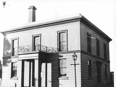 Tarnagulla History Archive
Photograph: Bank in Tarnagulla, Bank in Tarnagulla, circa 1866 to 1950
Murray Comrie Collection. This two-storey building was built in 1866 by the Colonial Bank of Australasia. Before this, the site had been occupied by Foo's shop. Whilst it was being built, the Colonial Bank operated from Company's Hotel (later known as Burstall Hall and the Council Chambers). The double-storey building in this image was used by the Colonial Bank from 1866 until 21st February, 1888. The premises were sold to the Union Bank for £2500. The Union Bank moved in and commenced operations on 6th June 1888, continuing until 1942. The building was later used as a general store until the 1990s. It is now a private residence. This is a reasonable copy of an older original. Copy probably made by Murray Comrie in the 1960s.Monochrome photograph of the double-storey bank in Tarnagulla. tarnagulla, banks, union bank, buildings -
 Glen Eira Historical Society
Article - Carnegie Methodist Church, Neerim Rd, 252- 254, Carnegie
Various Leader Newspaper articles c 2010 – 2011 on the development of the church building as a Gallery, Coffee Lounge and residence and the subsequent fire at the site.carnegie methodist church, carnegie uniting church, neerim road, toolambool road, glen eira, carnegie, breslin gallery, fine art, kay conrad, grange road, art galleries, breslin anthony, st anthony’s primary school, artists, martin scott sen det., caulfield ciu -
 Federation University Historical Collection
Photograph - Photograph - Black and White, Former Wesleyan Church Ballarat, C1904
Former Wesleyan Church (now School of Mines Ballarat) Lydiard St South. In the 1920s this building was given a new Art Deco facade.Photographic copy of the former Wesley Church (now Ballarat School of Mines) Lydiard St South.photograph, former wesleyan church, wesleyan church ballaarat, ballarat school of mines museum, ballarat, buildings, ballarat school of mines botanical gardens, photography -
 Marysville & District Historical Society
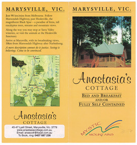
Ephemera (Item) - Information brochure, Anastasia's COTTAGES, Unknown
An information brochure regarding Anastasia's Cottages in Marysville. These cottages, along with most of the buildings in the township, were destroyed in the 2009 Black Saturday bushfires.An information brochure regarding Anastasia's Cottages in Marysville.marysville, victoria, australia, anastasia's cottages, information brochure, accommodation, 2009 black saturday bushfires -
 Marysville & District Historical Society
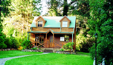
Photograph (Item) - Colour photograph, Unknown
A colour photograph of Ashlar Cottage B&B in Marysville. This cottage, along with the majority of the buildings in the township, was destroyed in the 2009 Black Saturday bushfires.A colour photograph of Ashlar Cottage B&B in Marysville.marysville, victoria, australia, accommodation, ashlar cottage b&b, 2009 black saturday bushfires, photograph -
 Phillip Island and District Historical Society Inc.
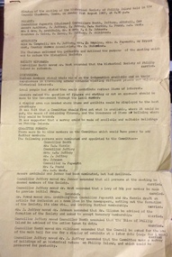
Document, Phillip Island and District Historical Society, Minutes of Phillip Island Historical Society inaugural meeting, 21 August 1967
Purpose of the meeting was the reforming of the Historical Society. Discussion included a suitable building to house exhibits, finance and insurance. A Committee of nine members was formed.Two typed pages on yellow foolscap sized paper of minutes of the Inaugural Meeting of the Historical Society of Phillip Island. 21st August 1967 held at the Council Chambers, Cowes.local history, phillip island historical society, local identities -
 Greensborough Historical Society
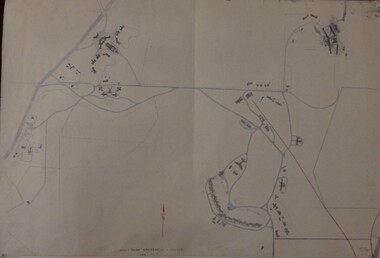
Maps, Mont Park, Gresswell, Larundel, 01/08/1949
Map of Mont Park area, including Larundel, Gresswell and Kingsbury Farm, between Plenty Road and Waiora Road, as at 1949, including buildings. Map of Mont Park area, including Larundel, Gresswell and Kingsbury Farm. Ink & pencil. Scale: 200': 1 inch49/147, R. G. H.mont park, larundel, gresswell watsonia, kingsbury -
 Greensborough Historical Society
Map, Municipality of Heidelberg Plan No. 481, 23/9/1949
Central area of Greensborough, South boundary Grimshaw Street, showing river and buildings in green and gradients in red. Adjoins Map No. 480 to West.Black & white map with features in red and green. Scale: 160 feet to 1 inch.greensborough, grimshaw street greensborough -
 Greensborough Historical Society
Oral History, The Dickson Family story / by Rosie Bray, 1951o
Bonnie Dickson recounts her early married life in Greensborough from 1955, the building of their home in Nell Street and their involvement in the local community.A primary source recollection of Greensborough in the mid-20th century.2 typed pages. Second copy of Item bonnie dickson, ray dickson, rosalie bray, nell street, greensborough, oral history. -
 Greensborough Historical Society
Letter, Letter regarding the history of Bundoora Primary School no 1915, 22/04/1971
The letter was written in response to a request for information on the history of Janefield (later Bundoora) Primary School. It includes details of the building, staff and enrolments in the 1870s.This letter has details of the history of the Janefield (later Bundoora) primary school and was used to establish a date for it's Centenary celebrations.A typed letter from the Education Department of Victoria dated 22nd April 1977.Niljanefield primary school, bundoora primary school, educational department of victoria -
 Greensborough Historical Society
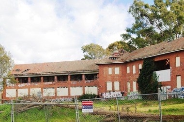
Photograph - Digital Image, Marilyn Smith, Larundel. Blocks A and B, front, 05/09/2017
This photograph shows the front of Blocks A and B at the old Larundel Hospital site. Some buildings on this site are heritage listed on the Victorian Heritage Database.Digital copy of colour photographlarundel hospital -
 Greensborough Historical Society
Photograph - Digital Image, Marilyn Smith, Larundel. Block B, rear, 05/09/2017
This photograph shows the rear of Block B at the old Larundel Hospital site. Some buildings on this site are heritage listed on the Victorian Heritage Database.Digital copy of colour photographlarundel hospital -
 Greensborough Historical Society
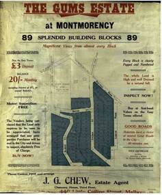
Advertising Leaflet, The Gums Estate, 28/11/1925
Sale brochure for The Gums Estate, 89 building blocks bordered by Rattray and Looker Roads Montmorency. J. G. Chew, Estate AgentColoured photocopy of sale brochure the gums estate, rattray road montmorency, looker road montmorency, sylvan street montmorency, alban street montmorency -
 Greensborough Historical Society
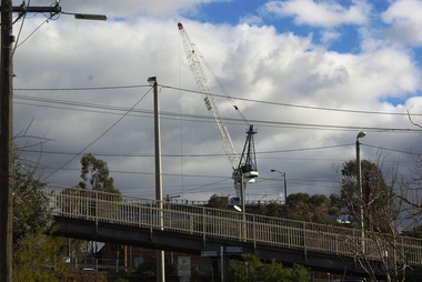
Photograph - Digital image, Marilyn Smith, Crane at Watermarc, 11/08/2016
Cranes on the skyline at Watermarc development 2016. New Banyule Council offices are being built at 1 Flintoff Street, over the Watermarc building.Digital copy of colour photograph.watermarc, one flintoff, banyule council -
 Greensborough Historical Society
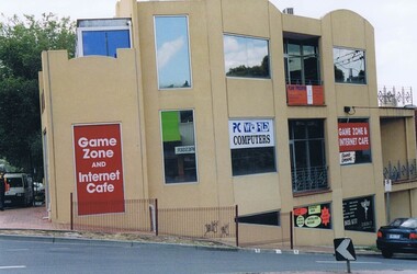
Photograph - Digital image, Frank Solomon, PC World corner Grimshaw and Main Streets Greensborough, 04/06/2010
PC World, corner Grimshaw and Main Streets Greensborough. This building was the former office of John Cecil Jessop, known locally as 'Jessop's Corner'.A record of the changing face of Greensborough.Digital copy of colour photographgrimshaw street greensborough, main street greensborough -
Greensborough Historical Society
Report, Melbourne Parks and Waterways, Happy Hollow Farm Complex : Conservation Strategy [excerpts], 1996_07
This report was commissioned by the Melbourne Parks and Waterways in 1996. It contains a history of the place and building, and garden and landscape features. There is a Statement of Cultural Heritage Significance. Happy Hollow was occupied (and probably built) by Emmett Whatmough in 1893, and owned by John Cully McLaughlin. There are other family connections among the Greensborough district pioneers.Copy of document, 16 pages plus maps.happy hollow, whatmough, bell, mclaughlin, melbourne parks and waterways. cultural heritage significance -
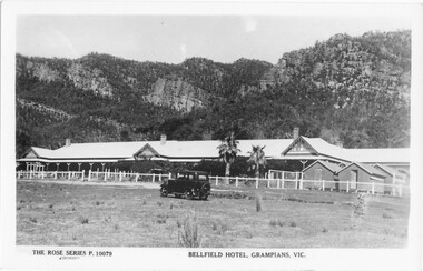 Halls Gap & Grampians Historical Society
Postcard - B/W, C 1936
Bellfield was a licensed hotel as of 1924 In July of that year, with the addition of a licensed building brought from Armstrongs, the enlarged establishment was opened as Bellfield HotelGuesthouse with car in foreground Sundial Peak in backgroundThe Rose Series P10079people, johnson, bellfield -
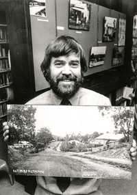 Eltham District Historical Society Inc
Photograph, Shire of Eltham Historical Society Secretary, Russell Yeoman, c.1988, holding an old photograph of Main Road, Eltham, 1988c
From Yeoman family file. Believe the photo was taken in Eltham Library in the former Shire of Eltham office building on Main Road, Eltham Black and white photographactivities, main road, shire of eltham historical society, heritage week, russell yeoman -
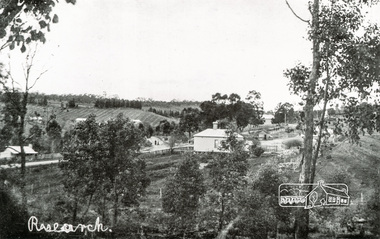 Eltham District Historical Society Inc
Photograph, Tom Prior, View looking down Ingrams Road, Research towards the rear of Doney's store
The small building at left of photo housed the school for a short period of time but it was too hot in summer and the community lobbied for a more substantial school.The Reynolds family were early settlers in Research. The Reynolds/ Prior collection of photographs were taken by Tom Prior, the maternal uncle of Ivy Reynolds, around 1900 and the 60 photos in the album give a fine overview of many of the landmarks of Research and Eltham over 100 years ago. lvy lived in the family home for many years at 106 Thompson Cres Research. Ivy's father, Ernst Richard Reynolds and grandfather, Richard Reynolds, lived at the same address. Ivy's father Richard worked for Mr. Trail on his property in Research. Reynolds Road is named after the family. Mr Tom Prior (wife Eva) worked at the Melbourne zoo. He was very innovative and made his own camera, using the black cloth hood to exclude the light. The photographs are a reminder of the rural nature of Research and Eltham and its rich heritage. Black and white photograph mounted in an album, the Reynolds/Prior Photograph Collection, this being one of 53 reproduced black and white images of early Eltham.The Reynolds/Prior Photograph Collection, Presented to the Eltham District Historical Society, 14 June 2006 by Ross McDonald. A second copy was also presented to the Andrew Ross Museum, Kangaroo Grounddoney property, general store, ingrams road, main road, research (vic.), research hotel, research primary school, reynolds prior collection, sepp, shire of eltham pioneers photograph collection -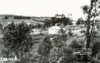
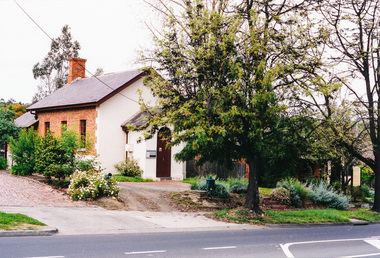 Eltham District Historical Society Inc
Photograph, Eltham Courthouse, 730 Main Road, Eltham, Before 2001
The Eltham Courthouse is the oldest building remaining in Eltham. Photo taken 2001 or prior as it was used to illustrate an newspaper article that year (see 03333)Colour photographeltham courthouse -
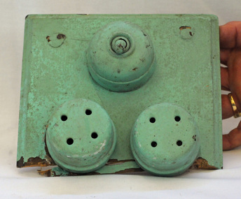 Orbost & District Historical Society
light switch
From the premises of Auctioneers James and Bird in the early 20th century. It was a small building beside abandoned shop on the corner of Tarra & Nicholson Streets. An early 20th century light switch from the James and Bird premises. It is painted pastel green and has large screws poking out through the mounting block. The two fuses were originally white porcelain and have been painted over. The brass fixtures have been painted over.On back -1917 electric lightlight-switch james-and-bird lighting