Showing 1540 items matching "low"
-
 Wodonga & District Historical Society Inc
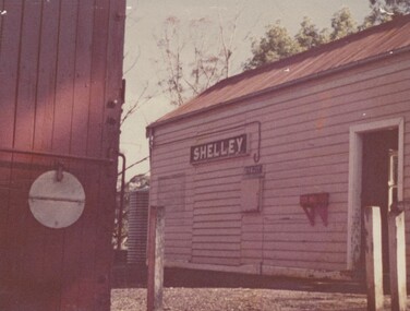
Photograph - Fred Rochow Railways Collection - Shelley Station
The Fred Rochow Railways Collection incorporates photos related to the operation of the Wodonga Railway Station including different types of trains and railways staff C. 1930 – 1990. It was donated to the Wodonga Historical Society by Fred Rochow, a railwayman who spent many years based in Wodonga. He joined the Victorian Railways on 17th June l947 and retired in 1988. For some time, he was a member of the Australian Federated Union of Locomotive Enginemen and served a term as a member of the Trades Hall Council. He had an extensive knowledge of the struggles that took place to achieve better conditions for railway workers. Fred worked for many years as a fireman and then worked his way up the ranks to driver, experiencing many changes from the days of steam locomotives through to diesel trains, locomotives and even the modern XPT train. He worked throughout Victoria at different stages of his career, with his final working years focused on the northeast of Victoria and the Albury to Melbourne line. After his retirement, Fred continued to share his love of steam miniature trains with the community. Shelley Railway Station - Shelley was once Victoria's highest railway station, located 781 metres above sea level. The Shelley Railway Station was opened in 1916 and closed in 1979. The railway was used early in its life to transport farmer’s livestock from the Upper Murray to Wodonga. From the 1950s the railway was used heavily to transport equipment and machinery from Wodonga to the Upper Murray to help build the Snowy Mountains Hydro Electric Scheme. The Snowy Hydro Scheme was completed in 1974 and after several years of low level use, the railway was closed. Some remnants of the Shelley Station passenger platform can still be seen today, along with some information boards. The Shelley Railway Station now forms part of the High Country Rail Trail.This collection has local and statewide significance as it captures images of trains, locomotives and personnel who operated the railway services in Wodonga and throughout Northeast Victoria. The railways played a critical role in opening up Victoria and connecting Australia for trade, business, social communication and transport.Shelley Railway Station. This image shows the tank where the hand brakes were lifted. They were applied again at the "up" side of Koetong for about another 10 miles then lifted near Bullioh.railways wodonga, fred rochow, shelley station, high country rail trail -
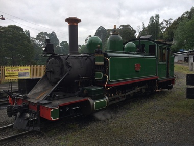
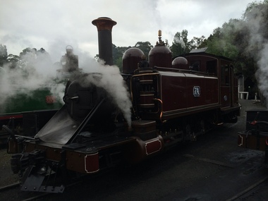
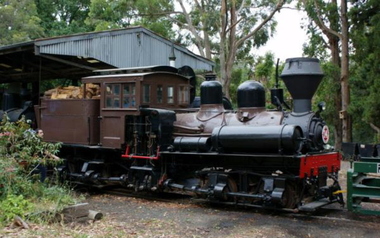 Puffing Billy Railway
Number 14 - Shay Locomotive (Builder’s Number 2549), 22 June 1912
geared steam locomotive Built by the Lima Locomotive Works, USA in 1912 (Builder’s Number 2549). “Class a” 13 Ton (13.3 tonne) . This locomotive hauled freight on the Ali-Shan Forest Railway in Taiwan and is capable of pulling 90 Tons (91.8 tone) loads over steep gradients at low speeds. . This A-type Shay locomotive was built by Lima Locomotive Works, Ohio (builder's number 2549 of 1912) for the Alishan Forest Railway, Taiwan. The Alishan Forest Railway featured a large fleet of Shay locomotives and many still survive, together with a portion of the railway which is now a tourist operation. Alishan Shay No.14 was gifted to the Puffing Billy railway in 1971 by the Alishan Forest Railway - Taiwan Government forest Bureau and arrived on the 12th October 1971 at the Puffing Billy Museum at Menzies Creek. Loco: Shay No.14 ( Shop Number 2549 ) Class: A 18-2 ( 2-cylinders / 2-trucks Class A ) Built for: Alishan Forest Railway Bulit by Lima Locomotive Corporation In service 22 June 1912 Samuels, Samuels & Co., Ltd. (D), Taipei, Formosa (Japan); For: Alishan Forest RY #14, Kirun (Keelung), Formosa, (Japan) (1945) Alishan Forest RY #14, Keelung (Chilung), Taiwan (12 Oct 1971) Puffing Billy RY #14, Belgrave, Victoria, Australia Gauge 30" Status Preserved - In Storage at Museum There is only one original LIMA mark left on any of the Alishan RY Shays and it has no number. All of their Shays have been re-built, changing much of the original Lima product. Most were renumbered for various reasons without regard to Lima Shop Numbers over the years. "Girder Type Frame" details from http://www.shaylocomotives.com/data/lima3354/sn-2549.htm Historic - Industrial Narrow Gauge Railway - Geared Steam Locomotive which worked on the Alishan Forest Railway, Taiwan.geared steam locomotive - Class: A 18-2 ( 2-cylinders / 2-trucks Class A ) - made of wood and iron and wrought iron, Glass14puffing billy, shay, geared locomotive, steam locomotive, industrial narrow gauge railway, 2'6", ali shan forest railway -
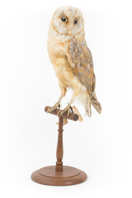 The Beechworth Burke Museum
Animal specimen - Barn Owl, Trustees of the Australian Museum, 16-1880
Barn Owls are the most widely distributed owl species in the world and one of the most widespread of all bird species, including in Australia. Barn Owls are sedentary and prefer open habitats such as grasslands, farmlands, and open woodlands, where they forage and hunt small mammals, particularly rodents, at night. Barn Owls nest in deep hollows in old trees, especially eucalypts, but also in caves, rock cavities, and sometimes cavities in buildings. Barn Owl's have a highly distinctive white heart-shaped face and pale underbelly feathers. They can be seen circling low above grassland areas at dusk or at night, and their drawn-out shrieking, hissing, and 'eerie' rasping sounds have led some rural populations to consider they have magical powers. Barn Owls vary in size but average 330-390mm in length, with wing spans between 800-950mm. Females are larger than males and most are a mix of white, pale brown and shades of grey speckled with fine black tear-shaped spots. They have a distinctive flat heart-shaped facial mask with oversized oblique black eye-slits and black irises. A ridge of feathers sits above the beak resembling a long nose. The feet vary in colour from pink to grey, and beaks can be pale to dark buff, corresponding to general plumage hue. This specimen is part of a collection of almost 200 animal specimens that were originally acquired as skins from various institutions across Australia, including the Australian Museum in Sydney and the National Museum of Victoria (known as Museums Victoria since 1983), as well as individuals such as amateur anthropologist Reynell Eveleigh Johns between 1860-1880. These skins were then mounted by members of the Burke Museum Committee and put-on display in the formal space of the Museum’s original exhibition hall where they continue to be on display. This display of taxidermy mounts initially served to instruct visitors to the Burke Museum of the natural world around them, today it serves as an insight into the collecting habits of the 19th century.This specimen is part of a significant and rare taxidermy mount collection in the Burke Museum. This collection is scientifically and culturally important for reminding us of how science continues to shape our understanding of the modern world. They demonstrate a capacity to hold evidence of how Australia’s fauna history existed in the past and are potentially important for future environmental research. This collection continues to be on display in the Museum and has become a key part to interpreting the collecting habits of the 19th century.This Barn Owl is medium sized with long wings and a short squarish tail. Its underbelly is pale and speckled with dark spots. The wings and tail feathers are light brown, grey and white with small, dark, tear-shaped speckles on the upper parts. It has a distinctive white heart-shaped facial disc with large black eyes and curved beak. This specimen stands on a wooden perch pedestal and it has metal and paper identification tags attached to its legs. Swing tag: 36. / Barn [torn] / Catalogue [torn] / Metal tag: 4058 /taxidermy mount, taxidermy, animalia, burke museum, beechworth, australian museum, skin, owls, birds of prey, tyto alba, heart-shaped faced owl, nocturnal birds, predator birds, 'harbingers of misfortune', demon owl, ghost owl, death owl, magical animals, lich owl, birds as omens, barn owl, carnivore, hissing owl -
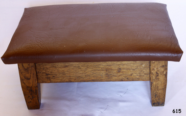 Flagstaff Hill Maritime Museum and Village
Furniture - Stool, ca. 1944
This low kneeling stool was used for prayer and was part of the original furnishings of the St Nicholas' Mission to Seamen's Church at 139 Nelson Place, Williamstown, Victoria. The Church was operated by the Mission to Seamen organisation. THE MISSIONS TO SEAMEN (Brief History: for more, see our Reg. No. 611, Set of Pews) The Missions to Seamen was an Anglican charity that served seafarers of the world since 1856 in Great Britain. It symbol is a Flying Angel, inspired by a Bible verse. Today there are centres in over 200 ports worldwide where seamen of all backgrounds are offered a warm welcome and provided with a wide range of facilities. In Victoria, the organisation began in Williamstown in 1857 as a Sailors’ Church, also known as ‘Bethel’ or the ‘Floating Church’ in an old hulk floating in Hobson’s Bay, Port of Melbourne. It soon became part of the Missions to Seamen, Victoria. In the year 2000 the organisation, now named Mission to Seafarers, still operated locally in Melbourne, Portland, Geelong and Hastings. The Ladies’ Harbour Lights Guild was formed in 1906 to support the Missions to Seamen in Melbourne and other centres such as Williamstown. Two of the most significant ladies of the Guild were founder Ethel Augusta Godfrey and foundation member Alice Sibthorpe Tracy (who established a branch of the Guild in Warrnambool in 1920). The Guild continued its work until the 1960s. In 1943 a former Williamstown bank was purchased for the Missions to Seaman Club. The chapel was named St Nicholas’ Seamen’s Church and was supported by the Ladies’ Harbour Lights Guild, the Williamstown Lightkeepers’ Auxiliary and the League of Soldiers’ and Sailors’ Friends. It ceased operation in 1966. A Missions to Seamen Chapel and Recreation Room was a significant feature of ports during the late 1800s and into the 1900s. It seemed appropriate for Flagstaff Hill to include such a representation within the new Maritime Village, so the Melbourne Board of Management of Missions to Seamen Victoria gave its permission on 21st May 1979 for the entire furnishings of the Williamstown chapel to be transferred to Flagstaff Hill. The St Nicholas Seamen’s Church was officially opened on October 11, 1981, and closely resembles the Williamstown chapel. This kneeling stool is significant historically for its origin in the St Nicholas Mission to Seamen's Church in Williamstown, established in 1857 to cater for the physical, social, and spiritual needs of seafarers. The Church originated in Bristol, England when a Seamen's Mission was formed in 1837. The stool is historically significant for its connection to the Ladies Lightkeepers’ Auxiliary, an organisation of women, formed to support seafarers. The connection of this stool to the Mission to Seamen and to the Ladies Lightkeepers’ Auxiliary highlights the strong community awareness of the life of people at sea, their dangers and hardships, and their need for physical, financial, spiritual and moral support. Stool; kneeling stool with textured vinyl cover and wooden base, with 4 wooden legs. The stool is part of the St Nicholas Mission to Seamen's Collection.flagstaff hill maritime museum and village, flagstaff hill, warrnambool, maritime museum, maritime village, shipwreck coast, great ocean road, religion, religious service, prayer, church furniture, prayer stool, worship -
 City of Moorabbin Historical Society (Operating the Box Cottage Museum)
Personal Effects, safety razor blade 'King Gillette'', 20thc
King Camp Gillette observed in 1902 that as existing, relatively expensive, razor blades dulled quickly and needed continuous sharpening, a razor whose blade could be thrown away when it dulled would meet a real need and likely be profitable. Safety razors had been developed in the mid-19th century, but still used a forged blade that dulled and rusted. In the 1870s, the Kampfe Brothers ( Germany) introduced a type of safety razor Gillette improved these earlier safety-razor designs, and introduced the high-profit-margin stamped razor blade steel blade. Gillette's innovation was the thin, inexpensive, disposable blade of stamped steel. Gillette's safety razor retailed for a substantial $5 half the average working man's weekly pay — yet sold by the millions. The most difficult part of development was engineering the blades, as thin, cheap steel was difficult to work and sharpen. This accounts for the delay between the initial idea and the product's introduction. To sell the product, Gillette founded the American Safety Razor Company on September 28, 1901 (changing the company's name to Gillette Safety Razor Company in July 1902). Gillette obtained a trademark registration (0056921) for his portrait and signature on the packaging. Production began in 1903, when he sold a total of 51 razors and 168 blades. The following year, he sold 90,884 razors and 123,648 blades, thanks in part to Gillette's low prices, automated manufacturing techniques and good advertising. By 1908, the corporation had established manufacturing facilities in the United States, Canada, England, France and Germany. Razor sales reached 450,000 units and blade sales exceeded 70 million units in 1915. In 1918, when the U.S. entered World War I, the company provided all American soldiers with a field razor set, paid for by the government, and as they were allowed to take them at discharge they continued their use of this product thus ensuring future sales. The company continues in the present day as the Gillette brand of Procter & Gamble, USA. Throughout the 20thC most men used this type of safety razor with disposable stainless steel razor blades to shave their beards prior to the introduction of affordable electric razors in 1960'sA blue packet of unused 'King Gillette' safety razor blades.on top of packet; Press with thumb / and snap end open / GILLETTE QUALITY THE / SAME THE WORLD OVER / FACTORIES IN / USA / CANADA , GREAT BRITAIN / MEXICO , FRANCE / COLUMBIA, GERMANY / BRAZIL, SPAIN / ARGENTINA, AUSTRALIA / GILLETTE TRADE MARK / KING C GILLETTE / RED. TRADE MARKS / GILLETTE (AUST.) PTY. LIMITED / MELBOURNE / DE 2023 / MADE IN AUSTRALIA / shaving equipment, safety razors, gillette king, proctor & gamble, moorabbin, bentleigh, cheltenham, -
 Puffing Billy Railway
6A - Victorian Railways Na class steam locomotive, 1901
6A Built in 1901 and painted two-tone green, this locomotive was issued to the Colac to Beech Forest line and was used in that line’s construction. Over the years, it saw service on all four lines, but mostly on the Colac to Crowes and Upper Fern Tree Gully to Gembrook lines. It was temporarily withdrawn from service in 1958 and returned to service at Belgrave in 1962 for the reopening of this line where it saw almost continuous service until being withdrawn in 1983. It has been restored, as far as possible, to its original condition with original design side tanks, low bunker, original size windows, etc., but a steel cow-catcher in place of the original style wooden one. It also has its original colour scheme of two-tone green with white lining. Loco: 6A In service Thursday, 18th July 1901 Livery two-tone green Owner Puffing Billy Gauge 762mm / 2' 6' Status Preserved - Operational Service History : Jul 1901 Colac - initial allocation of a new locomotive Jul 1901 - Nov 1908 Colac Mar 1909 - May 1909 Wangaratta Jun 1909 - Other Oct 1909 - Oct 1910 UFTG. Nov 1910 - Feb 1912 Colac May 1912 - Jun 1912 Wangaratta Jul 1912 - Sep 1914 Moe Oct 1914 - Aug 1924 Colac May 1925 - Jul 1927 UFTG. Aug 1927 - Oct 1928 Moe Jan 1929 - Sep 1930 UFTG. Sep 1930 - Jun 1932 Moe Dec 1932 - Workshops May 1933 - Colac Sep 1933 - May 1936 Moe Jun 1936 - Oct 1936 Workshops Oct 1936 - May 1942 UFTG. Sep 1942 - Apr 1949 Colac May 1949 - Apr 1950 Workshops May 1950 - Dec 1957 UFTG. Feb 1958 - Apr 1962 Workshops May 1962 - Belgrave - In Active Service at Puffing Billy Railway BelgraveVictorian Railways - Narrow Gauge NA class steam locomotive number 6A Victorian Heritage Register (VHR) Number H2187 Puffing Billy Locomotives and Rolling Stock Collection Dates that 6A worked on the Gembrook Line Nov-1909 to Nov-1910 May-1925 to Aug-1927 Jan-1929 to Sep-1930 Oct-1936 to Sep-1942 May-1950 to Feb-1958 May-1962 - Returned to Gembrook railway Oct-1977 - Transferred to PBR ownershipSteam Locomotive - with wrought iron frame with cast iron cylinders6Apuffing billy, victorian railways, narrow gauge, steam locomotive, 6a, 6na -
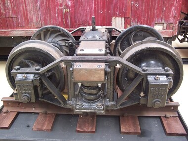 Puffing Billy Railway
Zeehan & North East Dundas Tramway Bogie 1896, wagon bogie, 1896
Zeehan & North East Dundas Tramway Bogie 1896 The North East Dundas Tramway (NEDT) was a 2 ft (610 mm) narrow gauge tramway on West Coast Tasmania that ran between Zeehan and Deep Lead (now Williamsford). It was part of Tasmanian Government Railways. The line was opened in 1896 to carry ore from the Williamsford mines to Zeehan where it would be loaded onto another train for shipment to Burnie. The narrow-gauge (2 ft) was chosen because of the extremely difficult terrain that the railway crossed, requiring several big trestle bridges, including one at the foot of Montezuma Falls. After some rain the engine and carriages would get soaked by spray from the falls. There was a break-of-gauge with the mainline 1,067 mm (3 ft 6 in) system at Zeehan. The railway was closed in 1932. The rolling stock for the Tramway was built in the Launceston Railway workshops, and comprised twenty five eight-wheel low-side trucks, tare 3 tons 1 cwt. 1 qr., load 10 tons; six eight-wheel flat trucks, tare 2 tons 18 cwt. 1 qr., load 10 tons; two four-wheel bolster trucks, for carrying long timber, tare 1 ton 19 cwt., load 5 tons; and four passenger cars, each with six cross-seats with reversible backs, to carry eighteen passengers, also a locker for mails and parcels. All trucks and cars have cast-steel wheels 21 inches in diameter and are fitted with automatic vacuum brakes. The trucks have side levers and the cars have hand-screw brakes. The vacuum brake can be worked from the engine or from the passenger cars, which act as brake vans. When this brake was introduced, one effect was to accelerate the journey speed by about 10 minutes owing to more even running on down gradients. Historic - Industrial Narrow Gauge railway - Bogie used on the Zeehan & North East Dundas Tramway, Tasmania, Australia Bogie made from steel, iron and wrought ironZN & NTDS ML TRAM 1896 Griffinpuffing billy, bogie, zeehan & north east dundas tramway bogie, zeehan & north east dundas tramway, industrial narrow gauge railway, gauge: 2' (610 mm) -
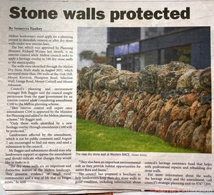 Melton City Libraries
Newspaper, Stone Walls protected, 2015
Dry stone construction as a technique is used for much more than paddock walls. Across the volcanic plains of western Victoriaare marvelous sheep dips, stock loading ramps, huts, dams, retaining walls, and the rich and largely undiscovered heritage of indigenous dry stone structures. Dry stone walls indicate many aspects of our rural environment; the geological beginnings of the way the landscape was created, the patterns of early settlement by pastoralists and squatters, the types of stock that grazed the land and the methods of cattle and sheep management, of the efforts to thwart the spread of rabbits .... "For the casual but interested observer dry stone walls are good to look at, to photograph, to get up alongside and see the way they are constructed, to appreciate the varying shapes and sizes of stones and learn of the techniques of keeping often quite rounded stones in place. Apart from walls and other dry stone structures on grazing land we can also see dry stone techniques used in other places and in other phases of our history. Indigenous Australians have built, and continue to build, structures for shelter or hunting or trapping eels and fish in rivers and estuaries around the country. At spots around our coast line there is evidence of simple stone structures built by early maritime explorers. Prospectors in early mining encampments used dry stone construction to build retaining walls or the low walls of rudimentary shelters. If the future of dry stone walls in the Australian landscape is to be assured. wall owners and local governments have to accept and embrace their custodial role in assuring the preservation and celebration of walls. This is not an easy task, but, along with putting the necessary statutory mechanisms to ensure their retention, it is a task that must be pursued. The Dry Stone Walls Association of Australia has as its primary goal the increase in awareness of wall owners and local governments of the importance of dry stone walls. It also seeks to increase the level of training of skilled and semi skilled wallers, and the gaining of rudimentary skills by farmers so that they can maintain their own walls". Melton Star Weekly article about the Stone Wallslandscapes of significance -
 Glenelg Shire Council Cultural Collection
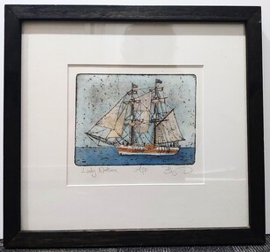
Artwork, other, BRIGIT THOMAS, Lady Nelson, c. 2015
From - theladynelson.org.au T The original Lady Nelson was built at Deptford, in England, in 1799, for service to the Transport Office on the River Thames. She was designed with sliding keels (centre boards), a device invented by Captain John Schank of the Royal Navy to allow surveying in rivers and shallow water ways. On completion she was selected for exploration services in the Colony of New South Wales and sailed for Port Jackson on 18 March 1800 under the command of Lieutenant James Grant. A brig of 60 tons, she carried a crew comprising the commander, two mates and twelve seaman. As she left the River Thames sailors on nearby ships ridiculed her because of her size and shape, calling her, as she sailed past, 'His Majesty's Tinderbox'. At Portsmouth on the 9th February 1800 she was fitted with four brass carriage guns, three to four pounders, in addition to the two guns already on board. Because of the heavy load she was carrying she was very low in the water, having only two feet nine inches freeboard amidships. The ship finally left Portsmouth on 17th March 1800 as part of an East Indian Convoy. From 1800 to 1825 the Lady Nelson operated around the Australian Coast and fulfilled a variety of roles including exploration, surveying, forming settlements, shifting goods and people around the colonies and capturing pirates. She played pivotal roles in the European settlement of Hobart, Northern Tasmania, Melbourne, Newcastle, Port Macquarie and Northern Territory. Those onboard charted much of Bass Strait, Port Philip, Newcastle, Port Macquarie and (with the Investigator) the coasts of northern New South Wales and southern Queensland. She also has links to other locations around the East Coast such as Trial Bay in NSW and the Mt Gambier area of SA. After 25 years of service while trading on the island of Baba the Lady Nelson was overrun by the islanders, the crew was killed and the ship stripped and later burnt and sunk. A replica of the Lady Nelson was built in the 1980s.Image of a tall ship in sail. The ship is flying both the Aboriginal flag and the Australian Flag. It sails on a calm sea. There are figures on the deck - four in total. The image is mounted on cream board and framed in dark timber. Etching, hand coloured,.Front: 'Lady Nelson A/P BT' - hand written, pencil in between etching and mount Back: Artist's business card glued to back of etching, lower left hand corner:ady nelson, femal artists, female artist, women -
 Melbourne Tram Museum
Letter - Thankyou letters - for events - MMTB - MTA, 1977 to 1987
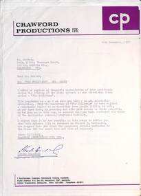
Set of letters written to Brian Cotter of the MMTB or MTA from 1977 to 1987 as either Special Clerk or Operations Project Office thanking him and or others for their work to facilitate tramway arrangements. 1 - Crawford Productions - 16/11/1977 - The Sullivans 2 - ditto - 27/4/1978 3 - ditto - 29/11/1978 - Christmas 3A - ditto - 30/4/1979 4 - ditto 30/5/1980 - The Sullivans - filming a segment on a tram 5 - The film house - 3/6/1980 6 - Crawford Productions 1/7/1982 - The Sullivans 7 - Fresh Flicks - 4/10/1982 - filming a new tram - Connie Snyders, 8 - National Book Council - 30/11/1982 - promotion - inspectors Turnball, Katina, Hawkings, Hornidge and La Rocca 9 - John Sexton Productions - Phar Lap - 10/1/1983 10 - Filmwings - undated 11 - Schofield, Sherbon Baker - 5/8/1983, and Mr McLeod 12 - Aust Broadcasting Commission - 15/12/1983 - "The Young Wife" and Mr Alan Parkins 13 - ditto - 12/7/1984 - "The Fast Lane" and Jack Bevis and Bruce Johnson 14 - Queen Victoria Medical Centre - 15/10/1985 - tram 676 and Mr Bernie Low 15 - ditto - 18/11/1985 - 676 and the Transit Band 16 - Fun Day at Wattle Park - tram 676 and Transit Band - 17/11/1985 17 - MTA - Kevin Shea - 11/11/1985 for 100 year celebrations 18 - Goosey Ltd - 16/9/1986 - filming 19 - Caulfield Festival - 17/12/1986 - for the Peace Tram 20 - Great Southern films - 2/2/1987 - filming for a TV commercial - also Tom Walton, Joe Kausey, Kevin Cooper and Dave Thomas. 21 - USP Needham - 16/10/1985 - TV shoots set of envelopes and cards from Crawford ProductionsDemonstrates thank you letters for assistance by the MMTB for filming for local productions using trams.Set of 20 letters, generally A4 size, one A5 and three envelopes.tramways, mmtb, mta, the met, filming, films, tv broadcasts, crawford producitons -
 Southern Sherbrooke Historical Society Inc.
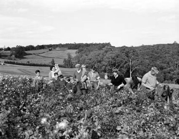
Photograph - Spykers family at Avonsleigh c.1960
Black and white photo showing a large family group in a flower field. In the background there are low hills with cleared paddocks and forested areas. According to the National Archives of Australia: 'Land was life for nurseryman Theo Spykers and his ancestors who had tilled the soil for generations; good land to own and to pass on to sons and their sons. At 42 Theo had one and a half acres near Rotterdam for a prosperous nursery, but he could only rent it and his family was growing. So, in 1948, Theo left his wife and six children at their home and set off by himself for Australia. Within a year he had paid a deposit on a broken-down property of 35 acres in the Dandenong ranges. His family joined him and they started to rehabilitate their new property. Mr and Mrs Spykers and twelve of their thirteen children pick chrysanthemums for sale in Melbourne, a city of 1,750,000. The children are; Theo, 20; Gerald, 15; Niko, 8; Frank, 5; Adolf, 22; Corrie, 11; Ria, 18; Terisa, 4; Anthony, 7; Tommy, 2; Elly, 10; Bill, 16.' Mr & Mrs Spykers are each holding one of the smaller children. This farm was on the corner of Birds Rd and Avon Rd, Avonsleigh. On the NAA records, Theodorus Gerardus Spykers arrived in Melbourne on the Muiderkerk on 27th February 1948. Black and white photo showing 15 year old Gerald Spykers carrying bundles of chrysanthemums tied ready for market. He is at the family farm on the corner of Birds Rd and Avon Rd, Avonsleigh. -
 Royal District Nursing Service (now known as Bolton Clarke)
Photograph - Photograph, black and white, Barry Sutton, 24.04.1974
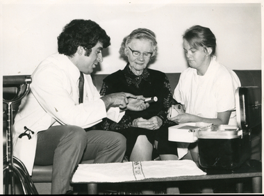
A Medical Student is explaining the use of a bottle of testing tablets to a lady who is a patient of RDNS. The Royal District Nursing Service (RDNS) Sister is holding testing equipment; i.e. the eye dropper and test tube in the receptacle, in her hands, and is observing the Medical Student giving instructions to the lady. The photograph is taken in the lady's home.Education was an integral part of Melbourne District Nursing Society (MDNS) from its inception in 1885, later called Royal District Nursing Service, (RDNS). Only Trained nurses (Nurses) were employed by the Society, and on visits to patients they taught the necessity of hygiene and cleanliness, as well as the need for a good diet, to bring about good health. Doctor’s lectures were later given at the MDNS home to instruct patients and their families on prevention of disease. Education to patients continued throughout the years regarding health care and the use of equipment in the home. In 1961 Education programs commenced at MDNS with Trained nurses (Sisters) receiving In-service education. Sr. Pat (Paddy) Rowley was a leader in In-service Education and established the RDNS Department of Community Nursing Education in 1962. Staff could also apply for scholarships to further their education outside of RDNS. At RDNS many programs were run, including: a Post Basic Course, Cardiac Rehabilitation Nursing, Haematology/Oncology Nursing, Palliative Care program, Diabetic Stabilization Program, Leg Ulcer Management Program, Wound Care Specialist Program, HIV/AIDS Nursing Care, Cystic Fibrosis Home Support, Veterans Home Care Program, Breast Cancer Support Program, Continence Management Program, Stomal Therapy Program, In-Home Lactation Support Program. RDNS Sisters attended several hospitals to observe and learn special care needed to some patients, e.g. to the Austin Hospital to learn the care required for paraplegic and quadriplegic patients at home and to Mount Royal Hospital to observe the care of patients in the rehabilitation ward. RDNS moved its Education Department from 452 St. Kilda Road to 448 St. Kilda Road in 1974. A Community Nursing Education Program was extended to student nurses from hospitals and to other nursing organizations. These Education programs kept the RDNS Sisters abreast of new techniques, such as changes in technology for e.g. new testing methods for detecting glucose levels in Diabetic patients. Sr. Nan Deakin obtained a Post Basic Certificate in Psychiatric Nursing and included this area in her Education lectures. Sr. Daphne Geldard specialized in the area of Alzheimer’s disease and Dementia. These Sisters visited patients in District areas with the regular RDNS Sister when required. Every member of staff, both professional and non professional staff, received regular education in the Education Department. In 1980, a Home Health Aide pilot study, funded by the Federal Government, the Brotherhood of St. Laurence and RDNS, with the program written and taught by Sr. Rowley, was evaluated as successful, and Home Health Aides were employed and worked in RDNS Centres under the supervision of the RDNS Sisters.In the left foreground of this black and white photograph is the partial view of two metal 4 prong sticks.To their right, seated on a long dark vinyl type couch, is a Medical Student who has short curly black hair; is wearing a white hospital coat over grey trousers, a white shirt, and a tie with small black and white squares. A stethoscope is folded in the pocket of his coat. He is turned toward the right of the photograph and is holding, on its side, a small bottle in his left hand and is pointing his right index finger to writing on its label. An elderly lady who is wearing glasses and has wavy grey hair is sitting to his right and is looking at the label on the bottle. She is wearing a black skirt and black sleeveless jacket over a black and white patterned blouse. Her hands are clasped in her lap. Sitting to her right, and facing the lady, is a Royal District Nursing Service (RDNS) Sister who has her long dark hair drawn back. She is wearing a white short sleeve gown over her uniform, and is holding a white oblong receptacle which holds a test tube, which has dark fluid in the bottom, and an eye dropper. In front of her, is a white 'inner tray' which is clipped onto the front edge of an open oblong black RDNS nursing case which is in the right foreground of the photograph sitting on a long, narrow, low table. On the table and to the left of the case a small white hospital drape runs along the table.Barry Sutton MA 24royal district nursing service, rdns, rdns patient care, rdns education -
 Brighton Historical Society
Clothing - Bodice, circa 1865
A bodice belonging to the family of George Ward Cole in the late 1800s. George Ward Cole was an early member of the Victorian Parliament and the family featured prominently in Melbourne Society in their time. They established a substantial home known as “St Ninians” at 10 Miller Street in 1841. The family reportedly entertained Melbourne’s first Royal visitor The Duke Of Edinburgh, Queen Victoria’s second son, at St Ninians in 1867. In later years St Ninians was subsequently subdivided and later demolished. A hand sewn cream silk satin evening bodice from c.1865. This bodice features a very low, wide scooped neckline with a set in sleeve and four small pleats across the head of the shoulder. The elbow length, straight fitted sleeves are trimmed with a pleated ruffle that extends around the arm finishing at the elbow crease at the inside arm and tapering to mid forearm length at the back. The fitted bodice, lined with waxed linen, fastens down the centre front with eight covered buttons of the bodice fabric. The front two panels wrap around the sides of the bodice to meet another series of panels creating a princess line with a delineated central spine. The waist position is just below the natural waist at the sides, tapering to an elongated front covering the belly. From the sides towards the back it curves up to the natural waistline and then down again to a central point. The bodice is decorated with strips of the same fabric, which has been tucked, pleated and padded to create ruching. The ruching edge has a multi coloured thread, suggestive of rosettes, on both sides. In the front of the bodice, a strip runs down the centre front, concealing the buttonholes, and finishing at the elongated point. It then goes up the bodice over the bust line where it meets the neckline. It follows the neckline around the nape of the neck and back down the front over the bust line to the centre front. More strips run around the base of the fitted sleeve near the elbow above the ruffle. The rosette like coloured thread finishes the base of the ruffle. st ninians, george ward cole, bodice, late 1800s, brighton, margaret morrison ward cole -
 Royal District Nursing Service (now known as Bolton Clarke)
Photograph - Digital image, c.1935
Each Ward in the Melbourne District Nursing Society After-Care Hospital, at 45 Victoria Parade, Collingwood, had a Sun Room which was well lit by its many windows. This digital image is taken in one of the Sun Rooms and shows the type of hospital beds, furniture and the uniforms worn by Sisters and nurses in the 1930s.Melbourne District Nursing society opened the After-Care Home, situated at 39 Victoria Parade Collingwood in 1926 following a public appeal for funds. The name changed from 'Home' to 'Hospital' in 1934. The After-Care Home was originally established to provide nurse-managed convalescent care to poor and underprivileged people who could not look after themselves at home due to illness or on release from hospital. Opening in 1926, at a cost of £27,000, the home included maternity, children’s and adult wards as well as accommodation for Matron, twelve nurses and four domestic staff. In 1930 an ante-natal clinic was opened at the home. During 1934 the Women’s Welfare Clinic including, at the time, a very controversial Family Planning Clinic, the first of its kind in Australia, was opened to support women at risk following multiple and difficult pregnancies. Major extensions occurred in 1936. Each Ward in the After-Care Hospital at 45 Victoria Parade, Collingwood, had a Sun Room which was well lit by its many windows. Several donors gave money to furnish some of the Wards. Following Government intervention, the After-Care Hospital was separated from the Melbourne District Nursing Society in 1957. The District division of Melbourne District Nursing Society became the Melbourne District Nursing Service and moved to 452 St Kilda Road; later, in 1966, with Royal patronage this became Royal District Nursing Service (RDNS). The After-care hospital continued to operate at the same address in Collingwood until 1985 when it became the Melbourne Geriatric Centre. This digital Image shows six men patients and nursing staff in a Sun Room in the Melbourne District Nursing Society After-Care Hospital. In the left foreground is a low bedside cupboard, beside it is a man with short dark hair lying in an iron framed hospital bed with a white cover pulled up to his shoulders. A Sister, who is looking at the camera, is wearing a grey uniform with a white collar, and a white veil over her short dark hair; she is standing behind, and at the head of the bed with her right hand holding the vertical bar of the bed frame. Behind her is an open door and then a nurse wearing a long white apron over her grey long sleeved uniform; she has a white cap over her shoulder length dark hair and is looking at the camera. Both of her hands are resting on an empty cane chair. Next along is a man with a bandage wrapped around his head and over his left eye. He is wearing dark clothing and is sitting on a padded cane chair, as are the rest of the men in the room. To the rear, in front of four long windows, are another two men, one on the left has short white hair and is wearing light clothing, and to his right is a man with short dark hair and is wearing a dark dressing gown over light colour pyjamas. On his right is a large vase of flowers on a tall white stand. On the right hand side of the photograph are another two men with short dark hair and wearing dressing gowns; part of a wall with windows can be seen behind them.mdns, after- care hospital, melbourne district nursing society, rdns, royal district nursing service -
 Bendigo Historical Society Inc.
Map - Laminated map of Lake Eppalock at full capacity
John Perry Collection. Laminated copy of map of Lake Eppalock at full capacity. Had highlighter markings of old roads which appear to be still in use. The dam was built by the State Rivers and Water Supply Commission of Victoria. The dam wall height is 45 metres (148 ft) and the main embankment is 1,041 metres (3,415 ft) long. At 100% capacity the dam wall was designed to hold back 304,651 megalitres (6.7014×10¹⁰ imp gal; 8.0480×10¹⁰ US gal) of water. The surface area of Lake Eppalock is 3,011 hectares (7,440 acres) and the catchment area is 2,124 square kilometres (820 sq mi). The controlled spillway is capable of discharging 8,040 cubic metres per second (284,000 cu ft/s). Lake Eppalock supplies both stock and domestic water to the Campaspe irrigation district. It also serves as a water supply to Bendigo and Heathcote and, in more recent times, Ballarat. The lake is a major attraction for those engaging in watersports, with a number of tourist parks and accommodation facilities available. Permissible activities on the lake include high-speed boating, water skiing, sailing, canoeing, fishing and swimming. The lake's water levels were low for approximately eight years between 2002 and 2010 during a prolonged drought, which restricted the amount of recreational activity until rainfall in the latter half of 2010 returned the lake to 100 percent capacity. Built between 1961 and 1964, Lake Eppalock remains the only water storage on the Campaspe River system.map, water, dam, reservoir, eppalock -
 Bendigo Historical Society Inc.
Map - Laminated worksheet - identification of inundated artifacts at Lake Eppalock
John Perry Collection. Laminated copy of worksheet identifying inundated artifacts at Lake Eppalock when at 10% capacity. The dam was built by the State Rivers and Water Supply Commission of Victoria. The dam wall height is 45 metres (148 ft) and the main embankment is 1,041 metres (3,415 ft) long. At 100% capacity the dam wall was designed to hold back 304,651 megalitres (6.7014×10¹⁰ imp gal; 8.0480×10¹⁰ US gal) of water. The surface area of Lake Eppalock is 3,011 hectares (7,440 acres) and the catchment area is 2,124 square kilometres (820 sq mi). The controlled spillway is capable of discharging 8,040 cubic metres per second (284,000 cu ft/s). Lake Eppalock supplies both stock and domestic water to the Campaspe irrigation district. It also serves as a water supply to Bendigo and Heathcote and, in more recent times, Ballarat. The lake is a major attraction for those engaging in watersports, with a number of tourist parks and accommodation facilities available. Permissible activities on the lake include high-speed boating, water skiing, sailing, canoeing, fishing and swimming. The lake's water levels were low for approximately eight years between 2002 and 2010 during a prolonged drought, which restricted the amount of recreational activity until rainfall in the latter half of 2010 returned the lake to 100 percent capacity. Built between 1961 and 1964, Lake Eppalock remains the only water storage on the Campaspe River system.map, artifacts, eppalock, reservoir -
 Bendigo Historical Society Inc.
Map - Black and white map pertaining to Lake Eppalock
John Perry Collection. Laminated copy of map pertaining to Lake Eppalock. Gives details of dwellings, bridges and ford crossings. The dam was built by the State Rivers and Water Supply Commission of Victoria. The dam wall height is 45 metres (148 ft) and the main embankment is 1,041 metres (3,415 ft) long. At 100% capacity the dam wall was designed to hold back 304,651 megalitres (6.7014×10¹⁰ imp gal; 8.0480×10¹⁰ US gal) of water. The surface area of Lake Eppalock is 3,011 hectares (7,440 acres) and the catchment area is 2,124 square kilometres (820 sq mi). The controlled spillway is capable of discharging 8,040 cubic metres per second (284,000 cu ft/s). Lake Eppalock supplies both stock and domestic water to the Campaspe irrigation district. It also serves as a water supply to Bendigo and Heathcote and, in more recent times, Ballarat. The lake is a major attraction for those engaging in watersports, with a number of tourist parks and accommodation facilities available. Permissible activities on the lake include high-speed boating, water skiing, sailing, canoeing, fishing and swimming. The lake's water levels were low for approximately eight years between 2002 and 2010 during a prolonged drought, which restricted the amount of recreational activity until rainfall in the latter half of 2010 returned the lake to 100 percent capacity. Built between 1961 and 1964, Lake Eppalock remains the only water storage on the Campaspe River system.eppalock, map, water, dam, reservoir -
 Bendigo Historical Society Inc.
Map - Map of overlay of lake Eppalock at full capacity. Map 'C'
John Perry collection. Map 'C'. Laminated map of overlay of Lake Eppalock at full capacity. Circa 1951. The dam was built by the State Rivers and Water Supply Commission of Victoria. The dam wall height is 45 metres (148 ft) and the main embankment is 1,041 metres (3,415 ft) long. At 100% capacity the dam wall was designed to hold back 304,651 megalitres (6.7014×10¹⁰ imp gal; 8.0480×10¹⁰ US gal) of water. The surface area of Lake Eppalock is 3,011 hectares (7,440 acres) and the catchment area is 2,124 square kilometres (820 sq mi). The controlled spillway is capable of discharging 8,040 cubic metres per second (284,000 cu ft/s). Lake Eppalock supplies both stock and domestic water to the Campaspe irrigation district. It also serves as a water supply to Bendigo and Heathcote and, in more recent times, Ballarat. The lake is a major attraction for those engaging in watersports, with a number of tourist parks and accommodation facilities available. Permissible activities on the lake include high-speed boating, water skiing, sailing, canoeing, fishing and swimming. The lake's water levels were low for approximately eight years between 2002 and 2010 during a prolonged drought, which restricted the amount of recreational activity until rainfall in the latter half of 2010 returned the lake to 100 percent capacity. Built between 1961 and 1964, Lake Eppalock remains the only water storage on the Campaspe River system.map, water, eppalock, dam, reservoir -
 Bendigo Historical Society Inc.
Map - Laminated map of Lake Eppalock empty. Map 'D'
John Perry Collection. Laminated map of Lake Eppalock empty. Map 'D'. Circa 1951. The dam was built by the State Rivers and Water Supply Commission of Victoria. The dam wall height is 45 metres (148 ft) and the main embankment is 1,041 metres (3,415 ft) long. At 100% capacity the dam wall was designed to hold back 304,651 megalitres (6.7014×10¹⁰ imp gal; 8.0480×10¹⁰ US gal) of water. The surface area of Lake Eppalock is 3,011 hectares (7,440 acres) and the catchment area is 2,124 square kilometres (820 sq mi). The controlled spillway is capable of discharging 8,040 cubic metres per second (284,000 cu ft/s). Lake Eppalock supplies both stock and domestic water to the Campaspe irrigation district. It also serves as a water supply to Bendigo and Heathcote and, in more recent times, Ballarat. The lake is a major attraction for those engaging in watersports, with a number of tourist parks and accommodation facilities available. Permissible activities on the lake include high-speed boating, water skiing, sailing, canoeing, fishing and swimming. The lake's water levels were low for approximately eight years between 2002 and 2010 during a prolonged drought, which restricted the amount of recreational activity until rainfall in the latter half of 2010 returned the lake to 100 percent capacity. Built between 1961 and 1964, Lake Eppalock remains the only water storage on the Campaspe River system.map, water, dam, reservoir, eppalock -
 Bendigo Historical Society Inc.
Document - Legend to maps A, B and C for Lake Eppalock
John Perry Collection. Laminated 'legend' for Maps A, B and C for Lake Eppalock also in this collection. Black and White definitions and descriptions of objects and markers found on maps. Circa 1951. The dam was built by the State Rivers and Water Supply Commission of Victoria. The dam wall height is 45 metres (148 ft) and the main embankment is 1,041 metres (3,415 ft) long. At 100% capacity the dam wall was designed to hold back 304,651 megalitres (6.7014×10¹⁰ imp gal; 8.0480×10¹⁰ US gal) of water. The surface area of Lake Eppalock is 3,011 hectares (7,440 acres) and the catchment area is 2,124 square kilometres (820 sq mi). The controlled spillway is capable of discharging 8,040 cubic metres per second (284,000 cu ft/s). Lake Eppalock supplies both stock and domestic water to the Campaspe irrigation district. It also serves as a water supply to Bendigo and Heathcote and, in more recent times, Ballarat. The lake is a major attraction for those engaging in watersports, with a number of tourist parks and accommodation facilities available. Permissible activities on the lake include high-speed boating, water skiing, sailing, canoeing, fishing and swimming. The lake's water levels were low for approximately eight years between 2002 and 2010 during a prolonged drought, which restricted the amount of recreational activity until rainfall in the latter half of 2010 returned the lake to 100 percent capacity. Built between 1961 and 1964, Lake Eppalock remains the only water storage on the Campaspe River system.map, water, dam, reservoir, eppalock -
 Bendigo Historical Society Inc.
Document - Collection of photographs from newspaper on a single page
John Perry Collection. Laminated copy of page from 'Weekly Times' newspaper, February, 1962. Nine images relating to establishing and building Eppalock Reservoir, 15 miles from Bendigo. The dam was built by the State Rivers and Water Supply Commission of Victoria. The dam wall height is 45 metres (148 ft) and the main embankment is 1,041 metres (3,415 ft) long. At 100% capacity the dam wall was designed to hold back 304,651 megalitres (6.7014×10¹⁰ imp gal; 8.0480×10¹⁰ US gal) of water. The surface area of Lake Eppalock is 3,011 hectares (7,440 acres) and the catchment area is 2,124 square kilometres (820 sq mi). The controlled spillway is capable of discharging 8,040 cubic metres per second (284,000 cu ft/s). Lake Eppalock supplies both stock and domestic water to the Campaspe irrigation district. It also serves as a water supply to Bendigo and Heathcote and, in more recent times, Ballarat. The lake is a major attraction for those engaging in watersports, with a number of tourist parks and accommodation facilities available. Permissible activities on the lake include high-speed boating, water skiing, sailing, canoeing, fishing and swimming. The lake's water levels were low for approximately eight years between 2002 and 2010 during a prolonged drought, which restricted the amount of recreational activity until rainfall in the latter half of 2010 returned the lake to 100 percent capacity. Built between 1961 and 1964, Lake Eppalock remains the only water storage on the Campaspe River system. dam, engineering, water, eppalock -
 Bendigo Historical Society Inc.
Map - Black and White map. Outline of Lake Eppalock. Map 'B'
John Perry Collection. Laminated copy black and white map. Map 'B'. Outline of Lake Eppalcok, overlayed on map. Circa 1951. The dam was built by the State Rivers and Water Supply Commission of Victoria. The dam wall height is 45 metres (148 ft) and the main embankment is 1,041 metres (3,415 ft) long. At 100% capacity the dam wall was designed to hold back 304,651 megalitres (6.7014×10¹⁰ imp gal; 8.0480×10¹⁰ US gal) of water. The surface area of Lake Eppalock is 3,011 hectares (7,440 acres) and the catchment area is 2,124 square kilometres (820 sq mi). The controlled spillway is capable of discharging 8,040 cubic metres per second (284,000 cu ft/s). Lake Eppalock supplies both stock and domestic water to the Campaspe irrigation district. It also serves as a water supply to Bendigo and Heathcote and, in more recent times, Ballarat. The lake is a major attraction for those engaging in watersports, with a number of tourist parks and accommodation facilities available. Permissible activities on the lake include high-speed boating, water skiing, sailing, canoeing, fishing and swimming. The lake's water levels were low for approximately eight years between 2002 and 2010 during a prolonged drought, which restricted the amount of recreational activity until rainfall in the latter half of 2010 returned the lake to 100 percent capacity. Built between 1961 and 1964, Lake Eppalock remains the only water storage on the Campaspe River system.map, water, dam, reservoir, eppalock -
 Bendigo Historical Society Inc.
Map - Black and white map pertaining to Lake Eppalock
John Perry Collection. Laminated copy of map relating to Lake Eppalock. Lists dwellings, ford crossings and bridges. The dam was built by the State Rivers and Water Supply Commission of Victoria. The dam wall height is 45 metres (148 ft) and the main embankment is 1,041 metres (3,415 ft) long. At 100% capacity the dam wall was designed to hold back 304,651 megalitres (6.7014×10¹⁰ imp gal; 8.0480×10¹⁰ US gal) of water. The surface area of Lake Eppalock is 3,011 hectares (7,440 acres) and the catchment area is 2,124 square kilometres (820 sq mi). The controlled spillway is capable of discharging 8,040 cubic metres per second (284,000 cu ft/s). Lake Eppalock supplies both stock and domestic water to the Campaspe irrigation district. It also serves as a water supply to Bendigo and Heathcote and, in more recent times, Ballarat. The lake is a major attraction for those engaging in watersports, with a number of tourist parks and accommodation facilities available. Permissible activities on the lake include high-speed boating, water skiing, sailing, canoeing, fishing and swimming. The lake's water levels were low for approximately eight years between 2002 and 2010 during a prolonged drought, which restricted the amount of recreational activity until rainfall in the latter half of 2010 returned the lake to 100 percent capacity. Built between 1961 and 1964, Lake Eppalock remains the only water storage on the Campaspe River system.map, water, dam, reservoir, eppalock -
 Bendigo Historical Society Inc.
Map - General view of area of proposed construction of Lake Eppalock. Map 'A'
John Perry Collection. Laminated map of proposed construction of Lake Eppalock. Map 'A'. Black and white map in laminate. Circa 1951. The dam was built by the State Rivers and Water Supply Commission of Victoria. The dam wall height is 45 metres (148 ft) and the main embankment is 1,041 metres (3,415 ft) long. At 100% capacity the dam wall was designed to hold back 304,651 megalitres (6.7014×10¹⁰ imp gal; 8.0480×10¹⁰ US gal) of water. The surface area of Lake Eppalock is 3,011 hectares (7,440 acres) and the catchment area is 2,124 square kilometres (820 sq mi). The controlled spillway is capable of discharging 8,040 cubic metres per second (284,000 cu ft/s). Lake Eppalock supplies both stock and domestic water to the Campaspe irrigation district. It also serves as a water supply to Bendigo and Heathcote and, in more recent times, Ballarat. The lake is a major attraction for those engaging in watersports, with a number of tourist parks and accommodation facilities available. Permissible activities on the lake include high-speed boating, water skiing, sailing, canoeing, fishing and swimming. The lake's water levels were low for approximately eight years between 2002 and 2010 during a prolonged drought, which restricted the amount of recreational activity until rainfall in the latter half of 2010 returned the lake to 100 percent capacity. Built between 1961 and 1964, Lake Eppalock remains the only water storage on the Campaspe River system.map, dam, water, weir, eppalock -
 Kew Historical Society Inc
Postcard, R McGeehan, The Effect of Storm. Train Passing Through Flood Waters, South Yarra, 25-1-07, 1907
SHARP DOWNPOUR. ONE INCH IN 45 MINUTES. SOUTHERN SUBURBS DELUGED. TRAIN STOPPED AT SOUTH YARRA. One of the sudden downpours of rain which occasionally fall in Melbourne occurred yesterday afternoon, when nearly an inch of rain fell in the course of three quarters of an hour, and caused a flood for an hour or two in certain localities. During the early part of the day, the sky had been clouded over, but there was nothing to indicate a storm of such intensity as that which followed. At about half-past 1 o'clock residents of South Yarra, South Melbourne, Prahran, and St. Kilda noticed a few drops of rain. Still, it appeared unlikely that there would be anything exceptional, until with startling suddenness at about 10 minutes to 1 o'clock, one of the heaviest downpours within the memory of residents burst upon those suburbs. A strange feature of the storm was that it was practically confined to an area of about three miles square. The city was but little affected, though at a spot as close as the Observatory 86 points of rain were recorded in three-quarters of an hour. Thunder and lightning accompanied the downpour, which was cyclonic in character, the rain driving heavily from all points of the compass as the cyclone passed. It was in South Yarra and Prahran that the rain fell heaviest. Within a few minutes after it commenced, the low-lying portions of Toorak-road and practically the whole length of Chapel-street were under water. The depression at the intersection of Toorak-road and Darling-street speedily filled to the dimensions of a small lake. Several shops were inundated, while the water from the higher levels rushed down like a mountain torrent, and in several in-stances swept through the rear of houses and shops, carrying furniture in a floating mass against the further walls. In one case a footbridge was carried bodily away and dashed to pieces. Darling-street itself Great Davis-street, and other low-lying and flat thoroughfares in the vicinity became flooded from kerb to kerb, while on the other side of the railway-bridge the valley between Kensington-road and River-street became filled for some minutes to a depth of several feet. Meanwhile the waters from South Yarra hill, seeking a lower level, found it in the railway cutting, and the excavations from South Yarra station to Prahran on the one line, and to the Chapel-street bridge on the other, were converted into a couple of canals. At the platforms at South Yarra the water was two feet deep on the permanent way, and towards Hawksburn, at the sudden depression under Chapel-street bridge, it was at one time deep enough to cover a tall man's head. Into this swirling mass of water the 1:50 p.m. train from Oakleigh plunged on its way to Melbourne. The impact caused a mighty fountain of water to rise to a height of about 20 feet above the level of Chapel-street and send clouds of spray in all directions. Under the belief that a terrible explosion had occurred residents braved the rain and rushed to the spot, only to find that the train had been brought to a stand-still in the middle of what seemed to be a river. The water was so high that it had entered the fire-box from below, extinguishing the fires and cutting off the steam supply. In the meantime the officials at the South Yarra station had been preparing for emergencies. Inspectors were on duty at intervals along the line, and the moment the alarm was given an extra engine was backed carefully down and continued on to connect with the stranded train without losing its own power. There was a delay of about ten minutes in the service for an hour or two, but by 5 o'clock all the trains were running on time again, and the water had run off all but the spot beneath the Chapel-street bridge. Here the water remained about four feet deep until nightfall, and throughout the afternoon several hundreds of people including biograph operators and photographers, were gathered around watching each train pass through. Even with the water two feet lower, this was a work attended with considerable difficulty. Each train had to absolutely force its way through the weight of water, almost enveloped by the spray thrown up, and it was only just able to negotiate the "ford" by using every ounce of steam. ... The Argus, 26 January 1907, p19.The item forms part of the Laurie Bennett collection of thirty-six postcards and photographs of Kew and early Melbourne, donated to the Kew Historical Society in 1980. The postcards in the Bennett collection, like other images in the Society's holdings date from the 1890s to the present and comprehensively indicate points-of-view or scenes considered historically, aesthetically or socially significant in the period in which they were produced.Postcard depicting a flood at South Yarra Station in 1907. The title and photographer's name are identified on the front of the postcard. Donated by L. Bennett, 1980flood - south yarra, trains - melbourne, postcards, r mcgeehan - prahran -
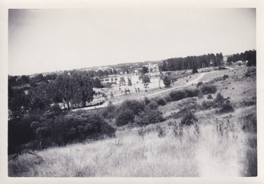 The Beechworth Burke Museum
Photograph, 1960s
This photo was taken in the 1960s from a northeast position looking down towards Lake Sambell, the caravan park, and the surrounding area. This photo was taken during a period of rejuvenation for the lake area including the opening of the caravan park in 1959 and the swimming pool area in 1961 (this pool is just visible in the centre of the photo). The popularity of caravanning in Australia exploded during this post-war period of the late 1950s and 1960’s. This popularity was driven by multiple factors, including: the stopping of fuel rations, the accessibility of car ownership through the manufacturing of affordable cars, technological developments in caravan design, and the increase in prosperity and leisure time for many Australians. Lake Sambell is an artificial lake that was developed on the previous site of the Rocky Mountain Mining Company workings and was officially opened by Minister for Lands, Mr Baily, on October 5, 1928. The disused and unattractive remains of the mine were converted into a recreational area intended for swimming, boating, and fishing. The lake is named after Mr L.H. Sambell, shire engineer and secretary of the Forward Beechworth Committee, who advocated for the enhancement of Beechworth into a tourist destination and was central to the planning and establishment of the lake. Funding for the project was raised by both competition funds and donations. Since the construction in 1928 several engineering issues have arisen. In 1939 the water levels were low, and the lake was considered both an eyesore and ‘mudhole’, Beechworth Shire Council sort funding to raise the height of the lake six feet to improve the quality of water. Throughout the 1940s the Beechworth Swimming Club tried to raise awareness and funds to address the structural engineering issues and improve swimming facilities at the lake. R.E. Carter, similar to L.H. Sambell, was a shire engineer who advocated the importance of positioning Beechworth as a tourist destination. Carter held the position from 1954-63 and organised many improvements to the Lake Sambell area including the caravan park in 1959, the lake swimming pool in 1961, water skiing and boating facilities, and increased the lake surface are in 1964. These improvements were financed mainly by grants from the Tourist Development Authority. This photograph is of historical significance as it documents Lake Sambell and the surrounding area in the 1960s after a phase of enhancements to improve the appearance and usability for both the people of Beechworth and tourists. It is also of social significance in providing an insight into the increase in leisure time and access to travel during a period of post-war prosperity.Black and white rectangle photograph printed on matte photographic paper and unmounted.Reverse: 1 / [logo KODAK/ VELOX/ PAPER] / C798 / 3535lake sambell, lake sambell caravan park, lake sambell swimming pool, caravan park, caravanning 1960s, rocky mountain mining company, l.h. sambell, r.e. carter, beechworth swimming club, forward beechworth committee, minister of lands, tourist development authority, lake swimming, swimming, boating, fishing, water skiing, beechworth 1960s, lake sambell fishing, lake sambell boating -
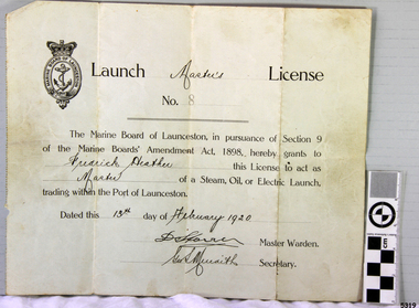 Flagstaff Hill Maritime Museum and Village
Document - License, Marine Board of Launceston, Launch Master's Licence, 13-02-1920
The Launch Master Frederick Heather was licensed to be Master of Launches within the Port of Launceston. Amongst the vessels that he captained was the S.S. ROWITTA. Fredrick’s son is one of the volunteers at the Low Head Pilot Station Museum, Frederick Heather is also related to a Harry Heather from Tasmania and was also a ship master, one of his ships being the "Alma Doepel", a sailing schooner built in 1903 and sailed by Harry for about 21 years until his death in 1937. Flagstaff Hill’s collection includes a painting of the Alma Doepel. SS ROWITTA: - The 1909 steam ferry, SS Rowitta, was installed as an exhibit at Flagstaff Hill in 1975 and was enjoyed by many visitors for 40 years. Rowitta was a timber steam ferry built in Hobart in 1909 using planks of Huon and Karri wood. It was a favourite of sightseeing passengers along Tasmania’s Tamar and Derwent rivers for 30 years. Rowitta was also known as Tarkarri and Sorrento and had worked as a coastal trading vessel between Devonport and Melbourne, and Melbourne Queenscliff and Sorrento. In 1974 Rowitta was purchased by Flagstaff Hilt to convert into a representation of the Speculant, a historic and locally significant sailing ship listed on the Victorian Heritage Database. (The Speculant was built in Scotland in 1895 and traded timber between the United Kingdom and Russia. Warrnambool’s P J McGennan & Co. then bought the vessel to trade pine timber from New Zealand to Victorian ports and cargo to Melbourne. It was the largest ship registered with Warrnambool as her home port, playing a key role in the early 1900s in the Port of Warrnambool. In 1911, on her way to Melbourne, it was wrecked near Cape Otway. None of the nine crew lost their lives.) The promised funds for converting Rowitta into the Speculant were no longer available, so it was restored back to its original configuration. The vessel represented the importance of coastal traders to transport, trade and communication in Australia times before rail and motor vehicles. Sadly, in 2015 the time had come to demolish the Rowitta due to her excessive deterioration and the high cost of ongoing repairs. The vessel had given over 100 years of service and pleasure to those who knew her. The licence is significant for its association with the Tasmanian early to mid-1900s passenger ferry, the S.S. Rowitta. It is connected to the history of the Rowitta, which was a large exhibit on display at Flagstaff Hill Maritime Village from the museum’s early beginnings until the vessel’s end of life 40 years later. The display was used as an aid to maritime education. The Rowitta represents the importance of coastal traders to transport, trade and communication along the coast of Victoria, between states, and in Australia before rail and motor vehicles. The vessel was an example of a ferry built in the early 20th century that served many different roles over its lifetime of over 100 years. Launch Master's License No 8 issued to Fredrick Heather to act as Master of a steam, oil or electric launch trading within the Port of Launceston. Date issued 13th February 1920. The license is printed with hand written details added.Handwritten on License "Master's" "Frederick Heather" "Master" "13th February 1920" Also two signatures (indecipherable) of Master Warden and Secretary.flagstaff hill, flagstaff hill maritime museum and village, warrnambool, maritime museum, maritime village, great ocean road, shipwreck coast, launch master's licence, rowitta, frederick heather, port of launceston, launch master's license, marine board of launceston, tarkarri, speculant, purdon & featherstone of hobart, passenger ferry 1909, vessel, charles street wharf launceston, sorrento -
 Flagstaff Hill Maritime Museum and Village
Container - Ink Bottle, from mid-19th century to 1902
This ink bottle is ‘boat’ shaped, which was a common design from the mid-1840s. It was crudely made; maybe it was rejected as a practice bottle or perhaps heat or pressure has distorted it. The bottle was recovered from the wreck of the Inverlochy and is part of the John Chance collection. Ink in the 1700s ink could be purchased in powdered or block form from apothecary shops, to be mixed with water as needed. Then in the mid-1800s chemists began selling ink in liquid form, in small, inexpensive and often attractive bottles. The small glass ink bottles were handmade, blown into a cup shaped mould, and sharply broken off from the blow-pipe at the neck, referred to as the English-made ‘burst-off’ finish. The neck was then filed, filled with liquid ink and sealed with a cork or wax. It was a quick, affordable container and made pen and ink writing available to the public. The name ‘penny ink’ bottles was a common title due to their low cost. INVERLOCHY 1895-1902 - The Inverlochy was a steel sailing barque built in Scotland in 1895 for international trade. In 1902 the Inverlochy left Liverpool under the command of Captain E.R. Kendrick. There were 21 officers and crew and the captain’s wife Mrs Kendrick, on board, bound for Australia with cargo that included tools, chemicals, liquor (beer, whisky, stout, rum, and brandy), steel, iron, wire netting, hoop iron, tinplate and pig iron), and steel wire for the Melbourne Tramway Company, tiles, soap, soft goods and earthenware. On December 18 almost at their destination, the Inverlochy ran aground on Ingoldsby Reef at Point Addis, near Anglesea. The crew and passengers left the ship via lifeboat and landed at Thompson’s Creek, then walked about 20 kilometres to Barwon Heads. Salvagers were interested in the 10 miles of cable in the hold. Mrs Kendrick’s ‘high grade’ bicycle was amongst the items salvaged but she lost her jewellery and two pianos. By February 1903 the ship had broken up and objects such as bottles and casks of liquor were washed ashore. Bad weather shook the wreck in June 1903, causing the ship’s spars and figurehead to be washed ashore. This boat shaped handmade ink bottle is historically significant for its association with communications and record keeping in the mid-to-late 19th century. The bottle is socially significant as an example of making a useful product affordable to every day people. This handmade glass ink bottle is significant for its connection with the John Chance Collection, which is historically significant as an example of artefacts from wrecks that had been lost in the coastal waters of Victoria from thirty to over one hundred years before John Chance and others discovered them. These artefacts are a sample of goods carried as cargo or personal possessions, and of ship hardware of that era. The ink bottle is significant through its connection with the barque, Inverlochy, The Inverlochy is significant for its cargo, which is a snapshot of the array of goods imported into Australia at the turn of the 19th century, including cable for the Melbourne Tramway Company. The Inverlochy is historically significant and is registered on the Victorian Heritage Database, VHR S338. The wreck of the Inverlochy is important as an accessible dive site that shows the remains of a large international trading vessel and its contents. It is valuable for an insight into Victorian era of shipping and maritime history.Ink bottle, thick clear glass, rectangular base with small round mouth, long sides have have a U shaped groove along the shoulders (used for resting pen handles). The outside surface has a white clay-type reside over it. Bottle is very bent and distorted. flagstaff hill, warrnambool, flagstaff hill maritime museum, maritime museum, shipwreck coast, flagstaff hill maritime village, great ocean road, john chance, inverlochy, scotland, captain e.r. kendrick, melbourne tramway company, tramway cable, ingoldsby reef, point addis, anglesea, thompson’s creek, barwon heads, boat ink bottle, cottage ink, penny ink, glass ink bottle, pen rest, writing accessory, victorian, antique, ink well, sheer lip, distorted body, handmade, mould blown, statoionery -
 Puffing Billy Railway
7A - Victorian Railways NA class steam locomotive, 1905
7A Built in 1905 and painted Canadian red & dark brown, this locomotive was issued to the Wangaratta to Whitfield line and saw service on all four lines with most of its service on the Upper Fern Tree Gully to Gembrook line. It was temporarily withdrawn from service in 1958 and returned to service at Belgrave in 1962 for the reopening of this line where it has seen almost continuous service since. 1979 saw the early two-tone green colour scheme applied to this loco as a trial even though it never historically carried it, but its physical configuration was not altered accordingly. It is now painted its original livery of Canadian red & dark brown and will eventually be returned, as far a possible, to its original condition with a low bunker, narrow ash-chute, etc. Loco: 7A In service Saturday, 6th May 1905 Livery Canadian red & dark brown Owner Puffing Billy Gauge 762 / 2' 6" Status Preserved - Operational Service History : May 1905 Wangaratta - initial allocation of a new locomotive May 1905 - Apr 1906 Wangaratta Jul 1906 - Nov 1910 Colac Feb 1911 - Jul 1912 Moe Sep 1912 - Dec 1917 Colac Mar 1918 - Sep 1921 UFTG. Nov 1921 - Sep 1923 Colac Dec 1923 - May 1925 UFTG. Jun 1925 - Aug 1925 Workshops Sep 1925 - Aug 1927 UFTG. Aug 1927 - Feb 1928 Workshops Mar 1928 - May 1928 UFTG. Jul 1928 - Moe Sep 1928 - Mar 1930 UFTG. Apr 1930 - Sep 1930 Workshops Oct 1930 - Oct 1936 UFTG. Nov 1936 - Moe Dec 1936 - Aug 1945 UFTG. Dec 1946 - May 1953 Colac Sep 1953 - Oct 1954 Moe Dec 1954 - Jun 1955 Workshops Nov 1955 - Dec 1957 UFTG. - Stored Feb 1958 - Apr 1962 Workshops May 1962 - Belgrave - In active service at Puffing Billy Railway Belgrave Victorian Railways - Narrow Gauge NA class steam locomotive number 7A Dates that 7A worked on the Gembrook Line Mar-1918 to Nov-1921 Dec-1923 to Jun-1925 Sep-1925 to Aug-1927 May-1928 to Apr-1930 Oct-1930 to Nov-1936 Dec-1936 to Dec-1946 Nov-1955 to Feb-1958 May-1962 - Returned to Gembrook line Oct - 1977 - Transferred to ETRB ownership Steam Locomotive with wrought iron frame with cast iron cylinders7Apuffing billy, 7a, victorian railways, narrow gauge, steam locomotive -
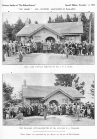 Old Colonists' Association of Ballarat Inc.
Photograph - Image, Ballarat Old Colonists' Association Homes, 1925, 1925
The homes were presented by the donors for the use of the Old Colonists' Association of Ballarat. The homes fulfil the original 1888 aim of 'aid and assist indigent or suffering old colonists' and 'to provide the shelter of a home for old and indigent pioneers of the gold fields, their widows, or anyone connected with the association'. From the minute books: "Mr and Mrs F.J. Williams, both natives of Ballarat, offered to build a cottage on the Association's ground at Perry Park [now Charles Anderson Grove] something after a style of the Hassell Homes. That offer was immediately followed by another from Mr S.W.J. Clark, a member of the Council. Both offers were promptly and gratefully accepted." The Old Colonists' Association Ballarat Inc. is a not for profit charitable organisation providing accommodation for elderly people. It manages over 40 Home retirement village at Charles Anderson Grove Ballarat. Accommodation is offered at significantly below market rates. It has been providing low cost accommodation to the elderly since the 1920s. The Association Council overseas the running of this facility on a voluntary basis. One of the first objectives of the Association was "to provide the shelter of a hose for those Pioneers of the Goldfields whom the reverses of fortune have deprived of the means of procuring the comforts of life in their declining years." The first home at Charles Anderson Grove was built in 1925. Before that time the Association provided relief for needy pioneers. relief included monthly monetary payments, loads of firewood, medical assistance and distribution of Christmas boxed of groceries to deserving pensioners, and in some cases payment of burial costs. == Purposes == ::a) The dominant purpose of the Association is to give public benevolent relief as a charity, but providing independent living accommodation in our Retirement Village for person in need who are over 65. ::b) To raise funds by membership subscription, commercial and residential rents, donations, gifts and voluntary work, for the purpose of providing direct relief of poverty, distress, misfortune or helplessness. ::c) To maintain the important heritage and ongoing viability of the Old Colonists' Association.Two black and white images of Old Colonists' Association homes from a Special Christmas edition of the Courier in 1925. The top image shows 'Clark Cottage', erected by S.W.J. Clark, and the lower image shows the 'Williams Cottage' erected by Mr and Mrs F.J. Williams. The cottages are locate in Charles Anderson Grove, Ballarat. old colonists' association ballarat, old colonists' club, charles anderson grove, clark cottage, williams cottage, perry park, s.w.j. clark, f.j. williams, old colonists' assocoation