Showing 2958 items
matching miles
-
 Eltham District Historical Society Inc
Photograph, Liz Pidgeon, Heritage Excursion; East of Eltham, 6 Sep 2014, 20 May 2017
Newsletter No. 218, September 2014 September Excursion - East of Eltham Walk In Newsletter No. 197, March 2011, there was a brief history of Crown Allotment 15 Section 5 Parish of Nillumbik (CA 15) a parcel of land of a quarter of a square mile extending from Eucalyptus Road to Reynolds Road at the eastern extremity of Eltham. From the 1940s it was known as Stokes orchard. In later years it has been subdivided for residential purposes but leaving significant areas as power line and water supply reserves and bushland reserves that are habitat for the threatened For our excursion on 6th September we intend to walk through CA 15 to a bushland reserve east of Reynolds Road. The walk will traverse the boundary between suburban Eltham and the non-urban areas to the south and east. This is a pleasant walk through residential areas and bushland. Along the way we will discuss the early and more recent history of CA 15 as well as local natural history and geology. This walk is about 3.5 km in length and will take 2 to 2.5 hours. It will start at 2pm at the corner of Eucalyptus Road, Pitt Street and Nyora Road.Born Digitaleltham east, eltham district historical society, heritage excursion, activities, nyora road, reynolds road, gum tree road reserve, diosma road, stokes orchard, eucalyptus road -
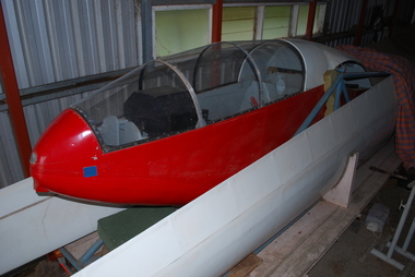 Australian Gliding Museum
Machine - Glider - Sailplane, 1958
The Altair was built between January 1956 and November 1958 with first flight on 20 December 1958. After a few flights the cockpit was lengthened and the glider flown by Cliff Gurr and Ron Adair to complete their FAI Gold C badges. Cliff set an unofficial Australian record for an out and return flight (between Gawler and Renmark) of 230 miles (368 km) in 1961. The glider was flown by only Ron and Cliff until Mervyn Waghorn joined Ron to fly it in the National Championships at Waikerie in 1967. For a period of time the glider was left in the care of some members of the Geelong Gliding Club. Doug Vanstan of the Geelong Gliding Club fitted a new canopy and rebuilt the aileron bellcranks to improve their operation. Subsequently the Altair was flown in competitions and at vintage rallies until the mid 1980s. On 31 March 1987 Alan Patching of the Victorian Motorless Flight Group purchased the glider from Ron for the sum of one shilling and named the owners as himself, Doug Vanstan and Ian Patching. It has been stored at Bacchus Marsh airfield since then. The glider is the only 18 metre wing span machine to have been designed and built in Australia.The Altair glider is a single place 18 metre span cantilever wing glider constructed from spruce and aircraft plywood. The laminar flow wing is completely covered in plywood with a ply balsa sandwich for the leading edge and the airbrakes are unique being located in the trailing edge of the wings. All these features were done in an effort to retain laminar flow over the wing and achieve a high performance. The wings, empennage and top of the fuselage are painted white with the rest of the fuselage red. The word ‘Altair’ appears on both sides at the top of the fin.australian gliding, glider, sailplane, adair, gurr, waghorn, vanstan, rees, patching, altair, adelaide soaring club, gawler, geelong gliding club, vmfg, zechner -
 Bayside Gallery - Bayside City Council Art & Heritage Collection
Map, H.B. Foot, Plan of the Brighton Estate containing 5120 acres, first special survey at Port Phillip, c. 1842
This plan records the Brighton Estate, also known as Dendy's Special Survey. In 1840 Henry Dendy, a farmer in Surrey, England acquired a "Special Survey" from the Commissioners for Land and Emigration which gave him the right to choose land in Port Phillip for the low price of £1 per acre for 5120 acres. Dendy appointed Jonathan Binns Were, as his agent, who later became a partner. Together, Dendy and Were decided on an area 5 miles south from Melbourne, bounded by North Road, East Boundary Road, South Road and to the west by Port Phillip Bay. Their Brighton Estate was first surveyed by T. S. Townsend in May 1841 and was re-surveyed by Robert Hoddle. Dendy and Were were making plans to sell the land and advertised a 30-guinea prize for the best subdivision which was to be divided into a village, marine residences, suburban and cultivation allotments, with the remainder being divided into country sections. The competition was won by H.B. Foot, who planned the village around a reserve and crescents and a 'green belt' forming the town boundary. brighton estate, dendy's special survey, special survey, henry dendy, jonathan binns were, w.b. were, survey, plan, map, brighton, george ward cole, baker's lithographer, hibernian, subdivision, town planning, cartographic material, h.b. foot -
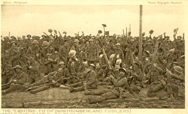 Federation University Historical Collection
Postcard - Sepia, The "Fighting Fifth" after the Battle of St Eloi, c1916
Holmes Family WW1 memorabilia. 06 Apr 1916 - The Battle of St Eloi Craters, Canadian Expeditionary Forces Major Operation. “… the British had been patiently tunnelling since August (1915) at nearby St Eloi, about three miles south of Ypres, and adjacent to the Canadian trenches. Throughout the winter, the tunnelling crept ever closer to a dominant German-held feature dubbed “The Mound.” When the tunnels were completed in early March, tons of explosives were emplaced in six locations and on March 27, 1916, at 4:14 a.m. the charges were set off. Two German companies were wiped out and large sections of the German trenches were destroyed, but the British 9th Brigade’s attack faltered and became a bloody close-quarters slugging match, with the last bomb crater captured only on April 3.” (Zuehlke, Mark. Daniel, C. Stuart. The Canadian Military Atlas. The Nation’s Battlefields from the French and Indian Wars to Kosovo. Stoddart Publishing Co. Limited. Toronto. 2001 p. 125)A number of World War One soldiers, members of the Northumberland Fusiliers celebrate after the battle of St Eloi. Some or wear tin helmuts.The "Fighting Fifth" (Northumberland Fusiliers) after the battle of St Eloi"chatham-holmes family collection, fighting fifth, northumberland fusiliers, tunneling, explosion, crater, world war one, postcard -
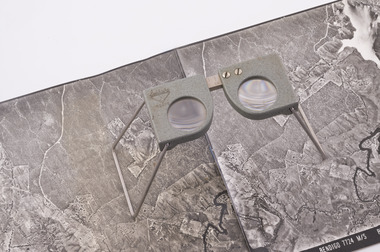 Forests Commission Retired Personnel Association (FCRPA)
Pocket Stereoscope
This pocket stereoscope was used to view a pair of separate and overlapping aerial photos as a single three-dimensional image. It was small and could be easily used in the field. Larger, mirror stereoscope were also available in some offices. The aerial images were used to map forest types, timber stands, new roads and tracks, firebreaks, boundaries of timber harvesting, plantations, bushfires, insect and disease attack and so on In 1928, the Forests Commission undertook its first major aerial photography project over 15,000 acres of forest which is said to be the first of its kind in Australia. During the Second World War, large areas of Victoria were photographed by RAAF and used to produce orthophoto maps. By 1945 aerial photography of 13,000 square miles (3.4 M ha) was completed, including much of the inaccessible eastern forests. The Forests Commission started developing its own small format photography in the early 1970s. Simple, cheap and rapid methods of obtaining photographs using 70mm and 35mm cameras were developed Small pocket stereoscope to interprete aerial photographs in the field Adjustable lenses on foldaway wire legsSokkisha Tokyoforest measurement -
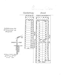 Ringwood and District Historical Society
Plan, Paradise Estate Subdivision, Ringwood, Victoria - circa 1925
Paradise Estate layout also included in Land Sale Brochure Titled Eureka Plan Book - Seven Delightful & Valuable Ringwood Estates - circa 1925, Reg. No. 5100.Subdivision plan of Paradise Estate, Ringwood, showing allotments for sale, with typed page attached showing block sizes and prices.Locality plan showing land for sale south of Canterbury Road, 1 Mile south of Ringwood Railway Station. Subdivison includes Canterbury Road and Dandenong Road (later Wantirna Road). Surveyors - McKenzie Aisbett & Webber, surveyors & engineers, 440 Little Collins Street, Melbourne, Telephone Central 11540. Subdivision for Mr Grenwood at Ringwood. Additional typewritten price list showing footage, price per foot, and price per block for Lots No. 1 to 60. Paradise Estate layout also included in Land Sale Brochure Titled Eureka Plan Book - Seven Delightful & Valuable Ringwood Estates - circa 1925, Reg. No. 5100. -
 Ballarat Tramway Museum
Photograph - Black & White Photograph/s, Yellow Express, 1942
Black and white photograph of Victorian Railway's Tram No. 52 being delivered to Elwood depot during 1942 by Yellow Express prime mover and low loader trailer - Truck registration - DP 635. Has the depot and water tower in the background and a person, the driver? alongside the truck. See image i1 for the details on the rear. Destination City, 4th Edition for date of manufacture.On rear of photograph in ink. 1. On left hand edge "PS can destroy photo when finished" 2. On upper 2/3rds of back "Photo wires being taken down to allow 1/2 section house to past it being 19-6 x 48 x 23 wide. Transported Preston to Reservoir by Yellow Express Melbourne Victoria" - would appear to refer to another photograph. - Dimensions in feet? 3. On lower 1/3rd, "Tram being transported Newport Railway Workshops to Elwood Depot , 11 mile. 45 long x 8-6 x 10 / Yellow Expx". Dimensions in feet.trams, tramways, vr, st kilda brighton tramway, elwood depot, vr class tramcars, yellow express, tram 52 -
 The Beechworth Burke Museum
Audio - Oral History, Jennifer Williams, Mrs Vanessa McDonald, 9 November 2000
Mrs. Vanessa McDonald was born in Beechworth in 1917. Christened, Agnes Bertha Collins, Vanessa changed her name in 1960. Mrs. McDonald's family's connection with gold mining in the district reach back to the first of Beechworth's gold rushes, when her great grandfather, a Dutchman who adopted the name Charles Collins, arrived in 1851-1852. Mrs. McDonald spent her childhood in the isolated hamlet of Stanley, in the area known as 'Little Scotland', where she recalls helping her mother to raise younger siblings, picking apples and walnuts on the family farm, and roaming the hills for wildflowers. As a young woman Mrs. McDonald attended religious and social gatherings in the local community. In 1940 she went to Melbourne to work as a mothercraft nurse during the Second World War. She met her husband at a Beechworth football match and was married at the Stanley Methodist Church in 1941. The gold diggings known as the 'Nine Mile' became the hamlet of Stanley, after the British Prime Minister, Lord Stanley, in 1858. By the late 1850s, Stanley boasted schools, an athenaeum, a church, a weekly newspaper and several hotels and other civic infrastructure to cater for a growing population. The area attracted large numbers of Chinese miners, whose presence was frequently resisted. Like other early Victorian mining settlements, Stanley was a hotbed of political and racial tensions during the gold rush. One side of the Nine Mile Creek was known as 'Little Scotland’, the other, 'Little Ireland'. A number of Christian denominations built congregations and churches in Stanley, including the Church of England, Methodist Church, the Catholic Church, and Presbyterian Church. Stanley became part of the United Shire of Beechworth in 1871. By 1880 timber was being cut and two sawmills were established by 1887. River-dredged gold mining consumed vast amounts of timber from the forests in the area, and in 1931 the first of several softwood plantations began. This oral history recording was part of a project conducted by Jennifer Williams in the year 2000 to capture the everyday life and struggles in Beechworth during the twentieth century. This project involved recording seventy oral histories on cassette tapes of local Beechworth residents which were then published in a book titled: 'Listen to what they say: voices of twentieth century Beechworth'. These cassette tapes were digitised in July 2021 with funds made available by the Friends of the Burke.Following the decline in the mining and associated industries during the early-mid-twentieth century, the Beechworth district experienced a period of general economic decline. On the east side of the Dingle Range, Mrs. McDonald's father, William Henry Collins, felled timber and the family were pioneer apple orchardists. The establishment of apple orchards in Stanley reflects changes to how land was used and contributes to our understanding of the historical development of rural communities following the gold rush. Mrs. McDonald's recollections are significant for understanding family and social life in a small rural town in years leading up to the Great Depression and prior to the Second World War. This oral history recording may be compared with other oral histories and items in the Burke Museum's collection. This oral history account is socially and historically significant as it is a part of a broader collection of interviews conducted by Jennifer Williams which were published in the book 'Listen to what they say: voices of twentieth-century Beechworth.' While the township of Beechworth is known for its history as a gold rush town, these accounts provide a unique insight into the day-to-day life of the town's residents during the 20th century, many of which will have now been lost if they had not been preserved.This is a digital copy of a recording that was originally captured on a cassette tape. The cassette tape is black with a horizontal white strip and is currently stored in a clear flat plastic rectangular container. It holds up 40 minutes of recordings on each side.Mrs Vanessa McDonald /listen to what they say, beechworth, oral history, burke museum, emigration, gold rush immigration, victorian gold rush, mining families, apple orchard, forestry, forest plantation, little scotland, stanley, twentieth century history, regional australia, rural australia, farming, harvest festival, great depression, dingle range, the nine mile, australian wildflowers, high country wildflowers, mothercraft nurse, rural and regional women, social history, collins, mrs. vanessa mcdonald, building community life, shaping cultural and creative life, fruit growers, family history, changes to land use in regional victoria -
 Flagstaff Hill Maritime Museum and Village
Badge - Gripman Badge, Stokes & Sons, Jul 1916 - Nov. 1919
This cable tram Gripman’s badge, or driver’s badge, was part of a tram driver’s uniform. The inscriptions on the front of the badge identify it as belonging to Gripman number 14, at the South Melbourne Car House depot of the Tramways Board. The Gripman Badge would be re-issued whenever another Gripman takes over the position. Cable trams were invented in America in 1873. In Melbourne, cable trams were in use from 1885 until 1940, with a network of up to 1200 cable cars or 'dummies' and trailers travelling at around 9.5 miles (15km) per hour along 46 miles (74km) of double tracks. The Gripman drove the dummy car, operating the heavy levers to connect the gripping gears to the cable installed in a slot in the road. To turn at intersections he would skilfully disconnect, freewheel around the corner and carefully reconnect to the continuously operating steel cable. Large winding gears in an Engine House along the line pulled the cable along, powered by steam engines and later electric engines. The gripping gears were in the centre of the car's floor with seating all around the sides, a dangerous place for curious children. , whose worried parents would guide them into the tram that was towed behind the dummy car. The Melbourne Tramways Board operated the cable trams between July 1916 and November 1919 after taking over from the privately operated Melbourne Tramway and Omnibus Company. In 1919, the Melbourne and Metropolitan Tramways Board (MMTB) took over the Tramways Board. Stokes & Sons: - The maker of the badge, Thomas Stokes, migrated to Melbourne from Birmingham in 1854 and set up business in Mincer Lane as a die-sinker, producing medals, tokens, buttons and silverware, and an engraving service. He moved to Flinders Lane in 1856. After a time, in 1894, the business became Stokes & Sons Pty: Ltd, electroplates and badge makers at Post Office Place in Melbourne. The maker's mark 'Stokes & Sons' was made on badges until 1962. LOCAL CONNECTION: -t was common practice to recycle the used cables from the tramway. For example, the Wollaston Bridge in Warrnambool, Victoria, is suspended by recycled cable tram Melbourne. (Other recycled cables were used for fencing wire.) -Portland's cable tram is an example of the cable trams used in Melbourne from 1885 to 1940.This badge was used to identify a Gripman who operated a cable car tram's dummy car for the Tramways Board in Melbourne between 1916 and 1919. It represents the need for people to be able to identify workers in the service industry, a need still addressed today by staff ID badges and digital identification. The badge also represents the period in Melbourne's history when cable cars were used for public transport for over four decades, gradually changing from steam to electric power. Trams still have an important role in Melbourne's public transport. Badge, round hollow metal dome with two open metal guides on the back. A cable tram Gripman (driver) badge with embossed inscriptions on the front and stamped on the back. There is a logo of entwined letters T and B on the front. It identifies Gripman number 14, South Melbourne, Tramway Board. It was made by Stokes & Sons of Melbourne. Impressed into the front: "S / 14 / M" "GRIPMAN" Logo intertwined "T" and "B" Embossed on reverse "STOKES &o SONS"flagstaff hill, flagstaff hill maritime museum and village, warrnambool, maritime museum, maritime village, great ocean road, shipwreck coast, badge, gripman, stokes & sons, numesmatics, tramway, tram, tram driver, uniform, cable tram, identification, cable car driver, tramway board, south melbourne, melbourne tramways board, tb, mtb, mmtb, melbourne and metropolitan tramways board, tramway button, gripman button, id, identification badg, staff badge, name badge, employee, grip car, dummy car -
 Bendigo Historical Society Inc.
Document - ALBERT RICHARDSON COLLECTION: SECRETARY FOR MINES ANNUAL REPORT 1911
Three page typed report titled ' Notes on diagram showing pitch lines, Bendigo'. Longitudinal sections along the lines of reefs or anticlines within the 8 mile block at Bendigo are shown in a diagram' (diagram not included with notes) Mines and reef lines mentioned in the report are : New Chum line, New Chum Railway mine, Catherine United mine, Hercules and Energetic mine, Garden Gully, Hustlers and Redan, Sheepshead Reef, Sea Mine, Garden Gully, Miller's line of reef and Bendigo Development Mine. The 'old stacks' or chimneys, on Bendigo are described. 'Among the earliest of the stacks built at Bendigo in connexion with Quartz crushing plant, are the two figured in this Annual report No 1 was situate in Sailor's Gully but was demolished about three years ago. This, if not the first, must have been one of the first built, for it had a stone inserted on which chiselled the date 1854. It was built altogether of rough masonry. The other, No. 2, is still standing at the Sheepshead line and was apparently of later date, the upper portion being of brick. They are intersting landmarks of an era that is rapidly passing.' Map attached to report showing location of stacks. Stack at Sailors Gully was near the corner of Murchison Street and Lester Street. The stack at Sheepshead ( Deborah Triangle area) was near the intersection of Belle Vue Road and Adam Street.bendigo, mining, pitch lines bendigo -
The Beechworth Burke Museum
Audio - Oral History, Jennifer Williams, Mr Herbert McFeeters, 4 May 2000
Herbert McFeeters as born in Wooragee Creek in 11th July 1905. Mr McFeeters would walk to school in Beechworth by foot, about 3.5 miles through the hills. It would take him and his siblings one hour to get to school. Mr McFeeters worked at the local tannery from the age of 14 for 11 years. After which he worked for himself, farming cattle and selling milk around the region. Mr McFeeters bought land from the Crown, who were selling lands after many miners had left the region. Mr McFeeters recalls the Chinese community that remained the Beechworth area and the social activities in the town, including the pictures, football games and Harvest Festivals. This oral history recording was part of a project conducted by Jennifer Williams in the year 2000 to capture the everyday life and struggles in Beechworth during the twentieth century. This project involved recording seventy oral histories on cassette tapes of local Beechworth residents which were then published in a book titled: Listen to what they say: voices of twentieth century Beechworth. These cassette tapes were digitised in July 2021 with funds made available by the Friends of the Burke. Mr McFeeters oral history provides detail of life in rural Victoria during the early 20th Century. Mr McFeeters describes his early childhood and working life, including details of the social activities This oral history recording was part of a project conducted by Jennifer Williams in the year 2000 to capture the everyday life and struggles in Beechworth during the twentieth century. This project involved recording seventy oral histories on cassette tapes of local Beechworth residents which were then published in a book titled: Listen to what they say: voices of twentieth century Beechworth. These cassette tapes were digitised in July 2021 with funds made available by the Friends of the Burke. This is a digital copy of a recording that was originally captured on a cassette tape. The cassette tape is black with a horizontal white strip and is currently stored in a clear flat plastic rectangular container. It holds up 40 minutes of recordings on each side.Mr Herbert McFeeters /listen to what they say, beechworth, oral history, burke museum, herbert mcfeeters, wooragee creek, reid's creek -
 Orbost & District Historical Society
black and white photograph, C1914
This photograph shows men working in the gravel pit at Newmerella just outside Orbost. Not long after this photograph was taken an accidental explosion killed three workers. In the newspaper, The Hobart Mercury on Saturday March 1914, There was this report: "EXPLOSION OF BLASTING CHARGE. THREE MEN KILLED. MELBOURNE, March 13 A fatal accident occurred this after- noon on the railway construction works at Hagen's Cutting, about two miles from Orbost, three men being killed. The victims were John Carroll, contractor, his son, Peter Carroll, and John Sullivan, a navvy. The gang had just finished work, and the three stayed behind to draw a blasting charge, which had missed fire yesterday. J. Carroll was using a pick, and it is presumed that the tool struck a percussion cap, and fired the charge. He and Sullivan were killed instantly, Carroll being literally blown to pieces. Fragments of his body and garments were recovered from the surrounding bush, and the main portion of the trunk, with leg attached, was hurled a distance of 200 yards. Peter Car roll was terribly- injured, and he died before medical aid arrived. ' This is a pictorial record of construction workers associated with the Orbost - Bairnsdale railway. This item is associated with the history of the Orbost-Bairnsdale railway line and therefore reflects the role that the rail line played in the social and economic history of Orbost. The Bairnsdale-Orbost railway was opened in 1916 to serve the agricultural and timber industry. Because of the decline in traffic and heavy operating costs, the line was finally closed in August, 1987. A black / white photograph of a large group of men with horses and wagons. Most are holding tools - picks, spades and shovels. Some of the wagons are loaded with soil.railway-construction east-gippsland-railway orbost-railway quarry-gravel-newmerella -
 Vision Australia
Map - Object, Brailled Map of Europe, 1939
This tactile map of Europe was created in 1939, and brailled by the Queensland Braille Map and Model Club. Cut and mounted by G. Vann with geographical inforamtion provided by Miss E Southern. The Queensland Braille Map and Model Club was a volunteer organisation which produced tactile maps from the 1920s to the late 1940s. These were sent as presents to schools, organisations and missions for people who were blind or vision impaired around Australia, New Zealand, Syria, India, Canada, Papua New Guinea and Africa. Due to free postage of Braille obtained by Tilly Aston and her compatriots, the maps were transported gratis within Australia and at a cheap rate overseas. When this map was made, East Prussia, Danzig and the Levant States were all separate countries. Some information about each country (name, area in sq miles and population) is written on a small door on the right hand side, which can be opened to reveal the same information in Braille. At the base is a braille and handwritten note "Information about maps gratis from Miss E Southern "Kingsley" George St, Brisbane. "For lending to the Blind" is written at the base of the wooden frame.1 paper attached to wooden mount with metal labels, on the right hand side a small door with country information on the front and opens to reveal the same in Braille. queensland braille map and model club, r.f. tunley -
 Surrey Hills Historical Society Collection
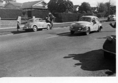
Digital photo, George L Coop, Redex trial on Whitehorse Road, Mont Albert, 1953
The Redex Reliability Trial 1953 -The first Redex round-Australia reliability trial covered of 6,500 miles (10,500 km), and had a first prize of £1,000. It attracted both amateur and professional drivers in a variety of cars. The route passed through Brisbane, Rockhampton, Townsville, Darwin, Alice Springs, Adelaide and Melbourne before returning to Sydney and attracted much public interest. At the time the idea of driving huge distances around the country in ordinary cars was novel and the logistics were challenging. In many parts of the country there simply wasn’t adequate accommodation or suitably located refuelling stops. The Shell Company facilitated the race by placing petrol dumps along the 5000 km route between Townsville and Adelaide. The race began at the Sydney Showground on 30 August when 192 cars left at three-minute intervals. Of the twenty top finalists, two thirds were sponsored. Ken Tubman and John Marshall won the trial in a Peugeot 203. However the Peugeot in this photo does not appear to be their car, judging by official photos of them with their vehicle, taken at the end of the trial. The Peugeot 203 was a popular car at the time and its reputation was enhanced after winning the trial. A black & white photo taken in Whitehorse Road, Mont Albert during the 1953 Redex Trial as a Peugeot 203 is passing 688 Whitehorse Road on the extreme left. The Peugeot 203 appears to have advertising on its panels indicating it was a competitor in the trial. On the far side of the road is a Morris Minor with a hatted man sitting on the bonnet, a woman standing close by and another man taking a photo of the passing cars. The houses in the background are partly obcsured by large hedges.george coop, mont albert, morris minor, redex trail, whitehorse road, peugeot 203 -
 Flagstaff Hill Maritime Museum and Village
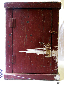
Furniture - Cupboard, Possibly 1920, when the City of Rayville was built
The biscuit locker came from the vessel the "City of Rayville", an American motor-driven freighter constructed in 1920. The ship was the second victim within 24 hours of an extensive minefield laid by German raiders in October 1940, during World War Two and the first American ship to be sunk in world war II. She was under the command of Captain Cronin and bound from Adelaide via Melbourne to New York, carrying a cargo of 1500 tons of lead from Port Pirie along with a cargo of wool and copper from Adelaide, when she struck a mine in the Bass Strait, six miles south of Cape Otway at 7:45 pm on 8th November 1940. The explosion was heard on shore at Apollo Bay; the force of it tore out the foremast and the ship sank within 25 minutes. There was a crew of 38 and all but one survived. A rescue crew of fishermen from Apollo Bay left shore in the dark and picked up the survivors from the dangerous sea taking them back to safety. The US Secretary of State Cordell Hull at the time wrote individual letters of thanks to all the rescuers involved. The biscuit locker is of historical and marine archaeological significance because of its association with the wreck of the City of Rayville. The vessel is listed on the Victorian Heritage Register No VHR S126. Additional significance is that the ship was the first American vessel sunk in the second world war and is still socially significant to the descendants of the City of Rayville crew and the Apollo bay fishermen who took part in the rescue.The external surfaces of the cupboard and the inside of the door are painted brown. The interior is painted blue the door has 2 metal hinges attached on the outside, each with 6 single-slotted screws and a wooden rotating door latch attached to the side of the door. There is a round eyelet on the door near the latch, the cupboard sides are each made from wood joined vertically and sit within a slightly wider, flat base and top. The frame of the cupboard is split with the paint on the outside of the cupboard scratched and chipped revealing a darker paint underneath. There is also a rough slash of white paint from the side of the cupboard going to about the Centre of the door. “PI/298” is hand written in black pen, paint or ink on the inside panel of the door in neat letters. "MS CITY OF RAYVILLE" stamped on back of cupboard in black paintcity of rayville, cupboard, locker, biscuit locker, 1940, world war ii, wwii, cape otway, german mines, american ship, flagstaff hill, warrnambool, flagstaff-hill, flagstaff-hill-maritime-museum, maritime-museum, shipwreck-coast, flagstaff-hill-maritime-village, rayvill