Showing 67370 items
matching ocean-east-gippsland-sailing-ship
-
 Flagstaff Hill Maritime Museum and Village
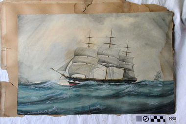
Painting - Maritime painting, ca. 19th century
Artist is unknown. This maritime painting is unsigned and the artist is unknown. The ship in this painting is unidentified.Painting is an example of 19th century artwork. Painting, rectangular watercolour, mounted on card. Maritime pointing depicts a three-masted ship at sea, sails rigged, bow facing left, hull is black, white and red. Second sailing ship on right in background. flagstaff hill maritime museum & village, maritime museum, flagstaff hill, warrnamool, painting, 19th century, ship at sea, seascape, wall decoration, maritime painting -
 Whitehorse Historical Society Inc.
Document, Blackburn East Primary School, 1991
Plans of Blackburn East Primary School No 4800, Eastern Metropolitan Region No. 27, Vicki Street Blackburn East 3130.Plans of Blackburn East Primary School No 4800, Eastern Metropolitan Region No. 27, Vicki Street Blackburn East 3130. With Rom Classification charts.Plans of Blackburn East Primary School No 4800, Eastern Metropolitan Region No. 27, Vicki Street Blackburn East 3130.blackburn east primary school no. 4800, vicki street -
 Whitehorse Historical Society Inc.
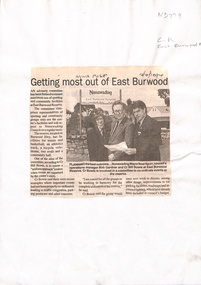
Newspaper - Article, Getting most out of East Burwood, 12/10/1994
'Getting most out of East Burwood', article on formation of an Advisory Committee for utilisation of East Burwood Reserve. Nunawading Post, 12 October 1994.east burwood reserve, parks and reserves, spurr, noel, gardner, robert, bowie, bill -
 Federation University Historical Collection
Map, Municipality of Ballarat East, 1857
Gold was discovered in Ballarat in 1851. This plan was created six years later and names some of the great gold locations of Ballarat East. It also shows the locality of the Eureka Stockade (1854) and the walking tracks and roads on the Ballarat East Goldfield.In 2007 this map was listed on the inaugural Ballarat Treasure's Register.Large map backed onto linen. The map has read and blue highlights, and identifies areas such as Mount Pleasant, Golden Point, White Flat, Nightingale, Malekoff, Old Post Office Hill, Red streak, Gumtree Flat, Old Gravelpits, Bakery Hill, Ballaarat Flat, The Camp, Specimen Gully, Pennyweight Hill, Warrenheip Gully, Gays Gully, Pennyweight Flat, Eureka, Black Hill, Pinchgut, Crocodile, Hit or Miss, Little Bendigo, Brown Hill, Mopoke, Cricket Reserve, Canadian Hotel, Ballarat Eastmount pleasant, golden point, white flat, nightingale, malekoff, old post office hill, red streak, gumtree flat, old gravelpits, bakery hill, ballaarat flat, the camp, specimen gully, pennyweight hill, warrenheip gully, gays gully, pennyweight flat, eureka, black hill, pinchgut, crocodile, hit or miss, little bendigo, brown hill, mopoke, cricket reserve, canadian hotel, ballarat eastm phillips, john phillips, field draughtsman, ballarat east, ballarat east map -
Lakes Entrance Regional Historical Society (operating as Lakes Entrance History Centre & Museum)
Postcard, 1970 c
Also a seconf postcard showing walway to ocean beach with holiday makers on the beach 05214.1 10 x 14.5 cmColour postcard showing view of footbridge, part of Cunninghame Arm, east end of township and Myer Street hill in background and approach to ocean beach Lakes Entrance VictoriaFootbridge and lake beach Lakes Entrance Vicislands, waterways -
Ringwood and District Historical Society
Envelope, History of Heathmont East Pre-School 1991
History of Heathmont East Pre-School 1991 -
Ringwood and District Historical Society
Envelope, Ringwood East Children's Library 1953-1967
Ringwood East Children's Library 1953-1967 -
Ringwood and District Historical Society
Envelope, Packet: Heathmont East Primary School incl Brief History
Heathmont East Primary School 3 pages -
 Stawell Historical Society Inc
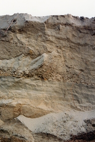
Photograph, Magdala East Tailings 1988
Soil layers Magdala East Tailings 1988gold, mining -
 Ringwood and District Historical Society
Photograph, Club Hotel, Mount Dandenong Road, East Ringwood in November 1969
Club Hotel, East Ringwood in November 1969Written on backing sheet, "Club 1969. Site originally marked out as local cemetery 1871. Hotel built as single storey 1877" The hotel has a long association with the Reddish family, thus given the name of "Daisy's Hotel". Ryman Healthcare bought the site in 2019, including the garden supply business next door, making up a 2.2ha area. The proposal was for a $220 million retirement village to be built. The location is next to Ringwood Lake with the old hotel being knocked down in the early 2020s. Was H17 in previous numbering system. -
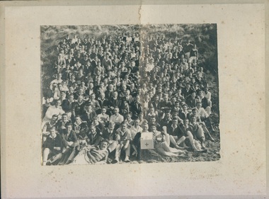 Uniting Church Archives - Synod of Victoria
Photograph, 1927
A report in "The Spectator" May 4 1927 noted that 300 - 400 men and boys attended the Easter camp.B & W photograph mounted on buff card of a large group of men and boys gathered on sand dunes at Ocean Grove. Young Men's Methodist Camp 1927 Ocean Grovemethodist, camp, ocean grove -
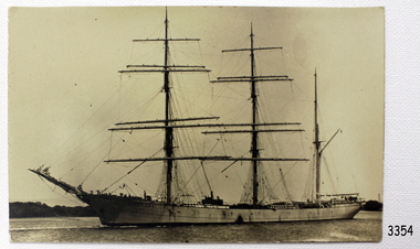
Lakes Entrance Regional Historical Society (operating as Lakes Entrance History Centre & Museum)
Photograph, 2000 c
The only sailing replica of a founding vessel of Australia. A brig of length 25.76m overall and 60 tonnes displacement. Plus history of original Lady NelsonColour post card of Tasmanian Sale training Association replica ship STV Lady Nelson off the coast of TasmaniaSTV Lady Nelson The only sailing replica of a founding vessel of Australia. A brig of length 25.76m overall and 60 tonnes displacement Plus History of original Lady Nelsonboats and boating, celebrations -
 Bayside Gallery - Bayside City Council Art & Heritage Collection
Photograph, Department of Crown Lands and Survey, Victoria, Brighton, Brighton East and Bentleigh, c. 1965-71
The Department of Crown Lands and Survey (1857-1983) was responsible for the administration of survey and mapping and the sale, occupation and management of crown land throughout its existence. This aerial photograph shows parts of Brighton, Brighton East and Bentleigh and was taken circa 1965-71.brighton, department of crown lands and survey, aerial photograph, bayside, port phillip bay, map, cartographic material, bentleigh, brighton east, dendy park, dendy street, centre road, nepean highway, south road, football -
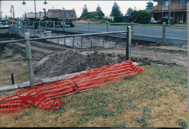 Port Fairy Historical Society Museum and Archives
Photograph, Lynda Tieman, 1995
East Beach November 1995 construction of recreation area Coloured photograph of shoring up the road on the East Beach during construction of recreation areaEast Beach November 1995 Filling ineast beach, development, trucks, filling -
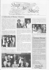 Mission to Seafarers Victoria
Magazine (item) - Newsletter, Mission to Seafarers Victoria, Ship to Shore , Issue Summer 2001/2002, November 2001
Ship to Shore was first printed in 1997. Inspired by the Jottings From Our Log, this modern version is generally published quarterly (Summer, Autumn, Winter, Spring) Articles are written by the mission's staff and give updates about shipping and seafaring news, staff, events, board Committee, heritage. It is sent by post or email to supporters, members, volunteers and friends of the mission. It is also available to the public in the Flying Angel club and online on the website. 20 October 2001: Reunion of Harbour Lights Guild former volunteers thanks to the work of Maria Culka: Enid Budds, Beverley Kent. The archive is put on display. In October: ABC News talks about the Mission. Ship to Shore is a valable source of informationship to shore, mission to seamen, mission to seafarers, flinders street, melbourne, victoria, news, events, seafaring life, shipping, sailors, seamen, sponsors, marketing, flying angel, staff, chaplains, community, welfare, board members, 1998, portland mission, hastings mission, noyoun park, ted cosens, statistics, sea sunday, 2001, bill romney, reverend bishop jeremy ashton, nigel porteous, shipping sector, keith dann, roy hope, geelong mission, international year of volunteers, lhlg, ladies harbour lights guild, heritage, judy douglas, noah park, donors, volunteers, maria culka, hlg, beverley kent nee oliver, ro kent, pat dann, abc news, the peter kaye trio, betty ashton, xmas, christmas, joan leslie -
 Bayside Gallery - Bayside City Council Art & Heritage Collection
Photograph, Department of Crown Lands and Survey, Victoria, Brighton, Brighton East and Bentleigh, c. 1965-71
The Department of Crown Lands and Survey (1857-1983) was responsible for the administration of survey and mapping and the sale, occupation and management of crown land throughout its existence. This aerial photograph shows parts of Brighton and Brighton East and was taken circa 1965-71.brighton, department of crown lands and survey, aerial photograph, bayside, port phillip bay, map, cartographic material, brighton east, dendy park, dendy street, centre road, nepean highway, south road, brighton golf course, golf -
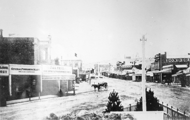 Stawell Historical Society Inc
Photograph, Main Street looking East from Coffee Palace area 1880
Main Street Looking East 1880 from weigh bridge area, taken from Coffee Palace verandah. Two story buildings with veranda's. Horse drawn vehicle center of image. Post office and Town Hall visible in background. Bond Drapery. J & A Price Wine Spirits. Bond Draper sign on right. Two Poppet Heads on Big Hill are the No2 North Waterloo and the Waterloo and Argyle Mines.Black and white photograph looking East along Main Street from Weighbridge area where two streets join. Horse drawn buggy in center of street with buggy. Big Hill in distance with two poppet heads just visible.stawell businesses streetscape -
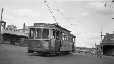 Ballarat Tramway Museum
Negative, Wal Jack, No. 21 outbound in Main Road Ballarat East, 15-9-1953
Print notes the "Made in Australia" side posters on the side of tram 21. Taken opposite Ballarat East Post Office, Main St 15-9-1953.Yields information about celebrations the intersection of Main Road and Humffray St and Ballarat 21.Negative and Digital image of the Wal Jack Ballarat Negative file of No. 21 outbound in Main Road Ballarat East at the intersection with Humffray St. Tram has a large "Buy Australia" panel on the side and destination of Mt Pleasant. - See Reg Item 5333 for another photo of the tram. in the background is a motor body workshop and Robson's Glass shop. Print also held - see item 8992trams, tramways, humffray st, main road, mt pleasant, decorated trams, buy australian, tram 21 -
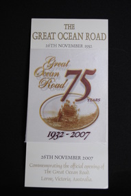 Anglesea and District Historical Society
Commemorative Card, November 2007
Cream coloured card with silk sash on front commemorating the 75th year of the Great Ocean Road. The back has a poem (see notes) written by H.G. Rickey, November 2007.THE GREAT OCEAN ROAD 26TH NOVEMER 1932 / THE GREAT OCEAN ROAD 75 YEARS. 1932-2007 / Commemorating the official opening of The Great Ocean Road, Lorne, Victoria, Australia.great ocean road, h g rickey, lorne -
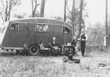 Ringwood and District Historical Society
Photograph, Mr. and Mrs. East camping in Illoura Ave., East Ringwood 1941
Typed below photograph, "Mr. and Mrs. East camping in Illoura Ave., East Ringwood opposite "Alexandra Ave. Christmas 1941." Written on backing sheet, "Caravan in paddock opposite home of Mr. & Mrs. Harry Thomas, Alexander Road, Ringwood, Christmas 1941". (2 copies). -
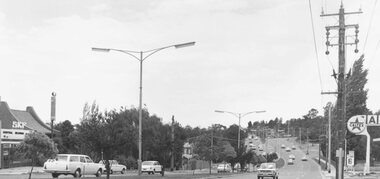 Ringwood and District Historical Society
Photograph, Maroondah Highway East, Ringwood- 1971. Looking east towards Mt Dandenong Road
Black and white photographWritten on back of photograph: "Maroondah Highway, looking east towards Mt Dandenong Road turnoff past lake. 1971." -
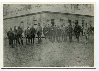 Orbost & District Historical Society
black and white photograph, late 19th century - early 20th century
Probably taken 1890's before Orbost was separated from Tambo. The Shire of Tambo was a local government area about 320 kilometres east of Melbourne. The shire covered an area of 3,506.86 square kilometres and existed from 1882 until 1994. Tambo was first incorporated as a shire on 6 January 1882, splitting away from the Shire of Bairnsdale. On 30 May 1892 it lost three-quarters of its land area when the Shire of Orbost was incorporated. A small amount was re-annexed as Cunninghame Riding on 3 January 1913. On 2 December 1994, the Shire was abolished, and merged with the City and Shire of Bairnsdale, Shire of Orbost, most of the Shire of Omeo and the Boole Boole Peninsula from Shire of Rosedale into the Shire of East Gippsland. ( more information Newsletter July 2010). This photograph is of Tambo Shire Council meeting at Faithful's Hotel, Nowa Nowa. It includes Snowy River Riding councillors. Mary Stirling, wife of Shire Secretary Thomas Telfer Stirling, took over the Nowa Nowa Hotel from Moses Faithful in 1895. Photograph includes: John Butter BESLEY, John William BORLAND, Charles Begg IRVINE, William J. LAMBOURN, James LARKIN, Ronald McDOUGALL, Donald McRAE, William ROADKNIGHT jnr., David WILLIAMS, James CAMERON, Charles Henry GROVE. (info. John Phillips) This item is associated with the Tambo Shire Council, a local government which no longer exists.A black / white photograph of a group of men standing in a line outside a large timber building.on back - "Tambo Shire Council . Meeting at Nowa Nowa - Stirling's Hotel"tambo-shire-council faithful's-hotel-nowa-nowa local-government -
Ringwood and District Historical Society
Badges, B&M, Ringwood East Primary School Badges "1924-1990", 1990
Badges produced for the school. Marked 1924-1990 coincided with the publication of the history of the school.2 metal circular badges, pale blue in colourRingwood East Primary School 1924-1990 -
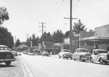 Ringwood and District Historical Society
Photograph, Ringwood East Shops, 1960
Written on back of photograph, "Ringwood East, 1960". -
 Ringwood and District Historical Society
Photograph, East Ringwood Ballet (undated)
Written on back of photograph, "East Ringwood Ballet". -
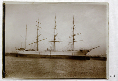
 Flagstaff Hill Maritime Museum and Village
Postcard
Black And White postcard of the sailing ship Penang. (Sh 225 Ships M - R)flagstaff hill, warrnambool, shipwrecked-coast, flagstaff-hill, flagstaff-hill-maritime-museum, maritime-museum, shipwreck-coast, flagstaff-hill-maritime-village, penang, post card, postcard, sailing ship -
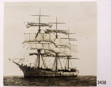
 Flagstaff Hill Maritime Museum and Village
Postcard
Black And White postcardof the sailing ship Parma. (Sh 237.1 Ships M - R)flagstaff hill, warrnambool, shipwrecked-coast, flagstaff-hill, flagstaff-hill-maritime-museum, maritime-museum, shipwreck-coast, flagstaff-hill-maritime-village, post card, parma., postcard, sailing ship -
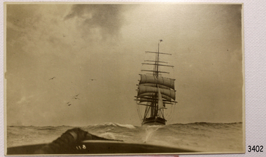 Flagstaff Hill Maritime Museum and Village
Postcard
Back and White postcard of the sailing ship Scottish Hills. (SH 275 Ships S)flagstaff hill, warrnambool, shipwrecked-coast, flagstaff-hill, flagstaff-hill-maritime-museum, maritime-museum, shipwreck-coast, flagstaff-hill-maritime-village, post card, scottish hills, postcard, sailing ship, postcard -
 Flagstaff Hill Maritime Museum and Village
Postcard
Black and White postcard of the sailing ship Tonawanda. ( SH 286 Ships T-Z)flagstaff hill, warrnambool, shipwrecked-coast, flagstaff-hill, flagstaff-hill-maritime-museum, maritime-museum, shipwreck-coast, flagstaff-hill-maritime-village, post card, tonawanda, postcard, sailing ship -
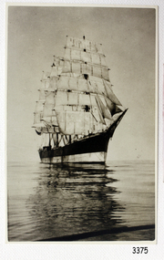
 Flagstaff Hill Maritime Museum and Village
Photograph
Photograph of the sailing ship Andromeda. 165mm X 119mm. SH 021 Ships A - B. flagstaff hill, warrnambool, shipwrecked-coast, flagstaff-hill, flagstaff-hill-maritime-museum, maritime-museum, shipwreck-coast, flagstaff-hill-maritime-village, andromeda