Showing 23669 items
matching sardine-creek
-
 Sunbury Family History and Heritage Society Inc.
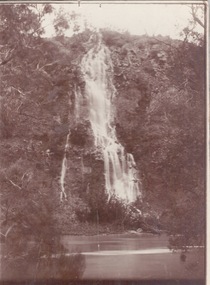
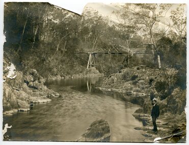
Photograph, c1920s
The waterfall is cascading down the Johnson Cliff which is on the Jacksons Creek downstream from Sunbury town.A sepia photograph with a narrow cream border mounted on cardboard of a waterfall cascading into the river below. johnsons cliff, jacksons creek, waterfalls -
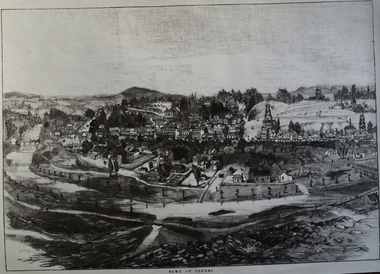 Clunes Museum
Photograph, CIRCA 1880
AN ETCHING OF VERY EARLY CLUNES. TREE GUARDS AROUND TREES ALONG CREEK BANK, ORIGINAL NAMED TULLAROOP CREEK.CLUNES TOWNSHIP, CRESWICK CREEK, DOUBLE STORY BUILDINGS AND MINE POPPET HEADS.TOWN OF CLUNESlocal history, photography, photographs, clunes township. -
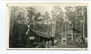 Orbost & District Historical Society
black and white photograph, late 19th century - early 20th century
Peter Jensen came to Martin's Creek (35 miles north of Orbost) in 1890 having been told that Martin's Creek would be on the railway line. He was a cooper who made the casks from silver wattles. He cleared the area for farming and then built an accommodation house, Danebo., which was well used by travellers to Bonang and Bendoc. . Gippsland was a relatively less developed part of Victoria in the nineteenth century. Danebo Hotel, Martin’s Creek, would have been an important stopping point for travellers to Bonang and Bendoc. The hotel is no longer standing A black / white photograph of a timber building - a house and another building at an angle. There are three people standing in front - a man. woman and child. On the left is a flag on a mast. In the background is bush.danebo-hotel-martins-creek jensen-peter -
 Falls Creek Historical Society
Poster - Kangaroo Hoppet 2017
The Kangaroo Hoppet is Australia’s premier long distance cross country ski race, and a member of the Worldloppet series of international cross country ski events. The first race at Falls Creek was held in 1979 under the name of “Australian Birkebeiner”. It was a 21km race with about 80 participants organised by the Birkebeiner Nordic Ski Club of Mount Beauty. The course started and finished at Falls Creek Alpine Resort and took participants out into the Bogong High Plains. After running the event for 10 years, it was decided they should become part of the Worldloppet series of marathon ski races. Representatives from the Birkebeiner Nordic Ski Club and the Australian Ski Federation attended the Worldloppet Annual Meeting in Finland in June 1990 to put the case for the acceptance of an Australian event into the Worldloppet series. Before being admitted, they had to demonstrate that the Birkebeiner Club could run a world class event, so three months later in August 1990 a 42km event named the Australian International Ski Marathon was held at Falls Creek together with a 21km Birkebeiner race and a 7km event called the Birkebeiner Lite. The event was approved by delegates from USA, Norway and Austria, in 1991 Australia became the 12th member of Worldloppet, with the condition that there had to be a name change. After some late night discussion allegedly involving red wine from North East Victoria the main event became the 42km Kangaroo Hoppet, with the minor events being the 21km Australian Birkebeiner, and 7km Joey Hoppet. In the winter of 1991, the first Kangaroo Hoppet was held. It was a great success and has been a regular fixture on the international ski calendar ever since. It features the main 42km event as well as a 21km event and a 7km event. The Hoppet brings the Australian snowfields to an international audience. In 2017 the Men's Winner was Miles Havlick from USA in a time of 1:37:24.2. The winner of the Women's event was Barbara Jezersek of Australia in a time of 1:46:59.8. This poster is significant because it documents an event which brings international attention to Falls Creek and the surrounding region.A poster featuring two Australian skiers on a downhill slope with a group of spectators in the background. Logos of Worldloppet, AGL, Falls Creek, Alpine Shire Council, Victorian State Government, the Birkebeiner Nordic Ski Club and FIS are across the bottom of the poster. To the left of image: KANGAROO HOPPET 26 August 2017 42 km 21 km 7 km FALLS CREEK AUSTRALIA Beside the logos: www.hoppet.com.au Photo: Mike - www.fallscreekphotos.com.aukangaroo hoppet, worldloppet events, falls creek, mt. beauty -
 Lakes Entrance Regional Historical Society (operating as Lakes Entrance History Centre & Museum)
Photograph, 1924
Miss Catt boarded in Roadknight Street, Lakes Entrance, in 1924, and walked all the way to Bunga Creek school from Lakes Entrance.Black and white photograph showing Miss Catt, teacher at Bunga Creek Primary School No. 336, East Gippsland. Bunga Creek Victoriaschools -
 Eltham District Historical Society Inc
Negative - Photograph, J. P. Lind, Hurst's Bridge, 1885
Looking northwest onto the first bridge at Hurstbridge, 1885. Timber bridge amid rural setting. Two horses graze in an open paddock in the foreground. A house is situated on a rise behind the bridge on a tree lined hill. The area of Hurstbridge was originally known as Hurst’s-bridge after the timber bridge built over the Diamond Creek near Hurst’s station in late 1881/early 1882 on the Hurstbridge-Arthurs Creek Road, Hurstbridge. It was built by John McDonald, of Arthur's Creek and was demolished and replaced in 1917 by a reinforced concrete arch bridge designed by John Monash. Cross Reference Photo No.(s): 1012/1013This photo forms part of a collection of photographs gathered by the Shire of Eltham for their centenary project book, "Pioneers and Painters: 100 years of the Shire of Eltham" by Alan Marshall (1971). The collection of over 500 images is held in partnership between Eltham District Historical Society and Yarra Plenty Regional Library (Eltham Library) and is now formally known as 'The Shire of Eltham Pioneers Photograph Collection.' It is significant in being the first community sourced collection representing the places and people of the Shire's first one hundred years.Digital image 4 x 5 inch B&W Negshire of eltham pioneers photograph collection, hurstbridge, bridge, diamond creek (river), diamond creek (creek), hurst's bridge -
 City of Kingston
Photograph - Colour, Paul Tresize, 1998
The name Mordialloc was derived from the name Moody Yallock, which comes from the Bunurong language. The Bunurong Peoples are the Traditional Owners of this area. The name means “high water” or “high creek”. In 1839, colonial authorities declared the mouth of the creek, and an additional 830 odd acres as an Aboriginal Reserve, although this proclamation was never gazetted. The reserved land included part of the Carrum Carrum Swamp which was abundant with wild life and natural resources. Regular encroachments, including land sales which began in 1863, were made on the land until 1878 when the Reserve was declared closed, and the land was opened up to land sales. Market gardening and suburban house lots quickly began to develop, and Mordialloc became a renowned picnic and holiday site. Mordialloc Creek is a popular bay side destination for local and visitors, and is a site for boating, kayaking, fishing and swimming, along with many other activities.Colour photograph of Mordialloc Creek, looking inland. Boats are moored on either side of the creek and the Bridge Hotel is visible in the background.mordialloc, bunurong, traditional owners, suburbs, boats, fishing, waterways, hotel -
 Orbost & District Historical Society
black and white photograph, 1897
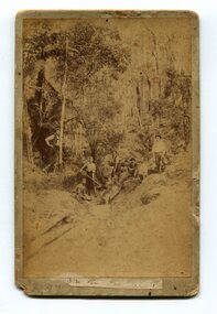
The photo shows miners looking for gold at Dead Horse Creek at Club Terrace. The subjects are unknown.This is a pictorial record of gold mining in East Gippsland in the late 19th century.A yellowed black / white photograph on grey buff card. It is of seven men in the bush mining for gold.on back - "Dead Horse Creek - Club Terrace, 1897"gold-mining gold-panning-club-terrace dead-horse-creek-gold -
 Marysville & District Historical Society
Photograph (Item) - Colour photograph, Pre 2009
A colour photograph of the Wilks Creek Bridge near Marysville in Victoria.A colour photograph of the Wilks Creek Bridge near Marysville in Victoria. The Wilks Creek Bridge is a former timber and bluestone road bridge on the Yarra Track, and is located just off the Black Spur route, between Narbethong and Marysville, Victoria, Australia. It was built in 1870 to the design of colonial Public Works Department engineer Clement Wilks as part of the construction of a new road to the Woods Point and Jordan Goldfields. Like many bridges of the period, it had a timber superstructure employing squared beams supported by struts and straining pieces, on cut bluestone abutments. The bridge was remodelled around 1900 by engineer John Monash of the famous bridge-engineering firm of Monash and Anderson. It was last used for heavy vehicular traffic in 1980 following the realignment of Marysville Road, and was left to decay until its demolishment in 2008. All timber traces of the bridge were destroyed in the 2009 Black Saturday fires. The handcrafted bluestone masonry wingwalls and abutments, especially shaped to receive timber struts, rate among the earliest of its kind surviving intact in Victoria.wilks creek bridge, yarra track, narbethong, marysville, victoria, clement wilks, wood's point goldfields, jordan goldfields, john monash, monash and anderson, 2009 black saturday bushfires -
 Eltham District Historical Society Inc
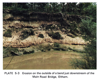
Work on paper (Sub-Item) - Photograph, Erosion on the outside of a bend just downstream of the Main Road Bridge, Eltham
Colour photograph of a muddy Diamond Creek (probably after a downpour) with siginificant water erosion apparent at the bend of the creek in Eltham.eltham, creek, vegetation, diamond creek, erosion -
Lakes Entrance Regional Historical Society (operating as Lakes Entrance History Centre & Museum)
Photograph, Carpenter, 1/05/1955 12:00:00 AM
Two other small black and white photographs of small boats moored in Chinamans Creek 04433.1 and at the mouth of Chinamans Creek looking out into Bancroft Bay towards Metung 04433.2, 7.5 x 10 cmBlack and white photograph of small boats in Chinamans Creek Metung Victoriaaccommodation -
 National Vietnam Veterans Museum (NVVM)
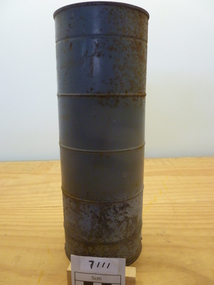
Equipment - Equipment, Army, Bendix SCR 878 BQ
Grey metal Cylinder with lid with 'sardine can' opener key. Inside is the antenna wire, weather balloon and carbide crystals that when in contact with sea water produce gas to inflate the balloon and raise the antennatransmitter antenna, bendix scr 878 bq -
 Whitehorse Historical Society Inc.
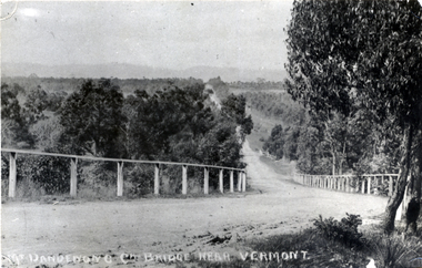
Photograph - Black and white photograph, Boronia Road, Vermont
Boronia Road Vermont approaching Dandenong Creek.Black and white photo of Boronia Road approaching Dandenong Creek, Vermontboronia road vermont, dandenong creek -
 Falls Creek Historical Society
Photograph - Ernest Forras and Julian Brown at Julian's Lodge with Beth Brown and Marnie Searles
Julian Newton-Brown arrived at Falls Creek in 1957. He had studied Pharmacy at Melbourne University. After developing a love for the mountains, Julian moved to Mt. Beauty and then Falls Creek. He worked for the SEC in the test laboratory at Rocky Valley reading weather instruments. By working several jobs, Julian was able to build a small lodge of 10 beds named “Arundel”, located at 18 Slalom Street, Falls Creek. The lodge is now the “Elk at Falls”. Arundel prospered and Julian extended it to include 32 beds and changed its name to "Julian’s” in 1961. When alcohol restrictions were eased in Falls Creek, Julian built a night club which he called “Big Julian’s” and later “THE MAN”. When Julian and his wife Beth retired and left Falls Creek, their son took over running the lodge. An active community man, Julian was a member of the Falls Creek Chamber of Commerce, a member of the SES, a stakeholder in Falls Creek, an author and a documentary maker. Julian Newton-Brown died in May 2020. Ernest Forras built Kooroora Chalet at Mount Buller with his brother, Aurel in 1953. They were both ski instructors and contributed greatly to the development of the ski industry.This item is significant because it gives details of an important lodge at Falls Creek, Victoria.A colour photograph of four friends inside Julian's Lodge, Falls Creekjulian's lodge, julian newton brown, falls creek ski lodges, earnest forrer -
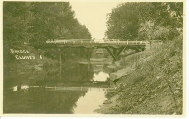 Clunes Museum
Photograph, D.S.KING. MOORE ST. EAST ARARAT
BRIDGE OVER CRESWICK CREEKBRIDGE OVER CREEK "BUTTER FACTORY" BRIDGE AT THE FOOT OF CAMERON ST. CLUNES.BRIDGE. CLUNES 6local history, document, postcard, bridges -
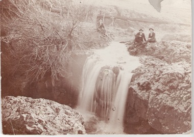 Sunbury Family History and Heritage Society Inc.
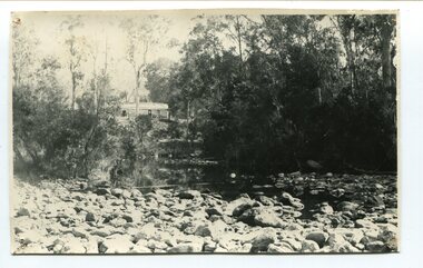
Photograph, c1910
The men are sitting above the waterfall and the Jacksons Creek close to the site of the former mill which utilised the water from the river to power the mill machinery.A sepia photograph mounted on cardboard of three men sitting on a river bank above a waterfall with a pipeline in the background.jacksons creek, sunbury -
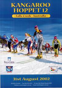 Falls Creek Historical Society
Poster - Kangaroo Hoppet 2002
The Kangaroo Hoppet is Australia’s premier long distance cross country ski race, and a member of the Worldloppet series of international cross country ski events. The first race at Falls Creek was held in 1979 under the name of “Australian Birkebeiner”. It was a 21km race with about 80 participants organised by the Birkebeiner Nordic Ski Club of Mount Beauty. The course started and finished at Falls Creek Alpine Resort and took participants out into the Bogong High Plains. After running the event for 10 years, it was decided they should become part of the Worldloppet series of marathon ski races. Representatives from the Birkebeiner Nordic Ski Club and the Australian Ski Federation attended the Worldloppet Annual Meeting in Finland in June 1990 to put the case for the acceptance of an Australian event into the Worldloppet series. Before being admitted, they had to demonstrate that the Birkebeiner Club could run a world class event, so three months later in August 1990 a 42km event named the Australian International Ski Marathon was held at Falls Creek together with a 21km Birkebeiner race and a 7km event called the Birkebeiner Lite. The event was approved by delegates from USA, Norway and Austria, in 1991 Australia became the 12th member of Worldloppet, with the condition that there had to be a name change. After some late night discussion allegedly involving red wine from North East Victoria the main event became the 42km Kangaroo Hoppet, with the minor events being the 21km Australian Birkebeiner, and 7km Joey Hoppet. In the winter of 1991, the first Kangaroo Hoppet was held. It was a great success and has been a regular fixture on the international ski calendar ever since. It features the main 42km event as well as a 21km event and a 7km event. The Hoppet brings the Australian snowfields to an international audience. In 2002 the Men's Winner was Stanislav Rezac from the Czech Republic in a time of 2:10:40. The winner of the Women's event was Belinda Phillips of Australia in a time of 2:30:53.This poster is significant because it documents an event which brings international attention to Falls Creek and the surrounding region.A coloured poster featuring group of Hoppet competitors on a clear day. The heading is in gold text and the logos of Worldloppet, Falls Creek and Tourism Victoria are included towards the bottom.In gold text at the top: KANGAROO HOPPET 12 FALLS CREEK AUSTRALIA Beneath the image: 31st August 2002 Tel: (03) 5754 3103 - Fax: (03) 5754 4475 - P.O. Box 400 Mount Beauty 3699 Website: http://www.netc.net.au/-hoppet/ Email: [email protected] kangaroo hoppet, worldloppet events, falls creek, mt. beauty -
 Orbost & District Historical Society
black and white photograph, first half 20th century
This appears to be the Boggy Creek bridge and to have been taken at Nowa Nowa. The Boggy Creek Bridge was built in 1916 as part of the Bairnsdale to Orbost extension to the main Gippsland Railway, and is situated in the middle of the township of Nowa Nowa, crossing a steep-sided and well-timbered creek-valley. This section of the line closed in 1987.This bridge plays a major part in the identity and history of the town of Nowa Nowa, since Boggy Creek’s steep sided valley divides the township into two components. It is part of the East Gippsland Railway line.A black / white photograph of a bridge across a creek. A young man in a suit is standing in the foreground.boggy-creek-bridge-nowa-nowa -
 Falls Creek Historical Society
Poster - Kangaroo Hoppet 2013
The Kangaroo Hoppet is Australia’s premier long distance cross country ski race, and a member of the Worldloppet series of international cross country ski events. The first race at Falls Creek was held in 1979 under the name of “Australian Birkebeiner”. It was a 21km race with about 80 participants organised by the Birkebeiner Nordic Ski Club of Mount Beauty. The course started and finished at Falls Creek Alpine Resort and took participants out into the Bogong High Plains. After running the event for 10 years, it was decided they should become part of the Worldloppet series of marathon ski races. Representatives from the Birkebeiner Nordic Ski Club and the Australian Ski Federation attended the Worldloppet Annual Meeting in Finland in June 1990 to put the case for the acceptance of an Australian event into the Worldloppet series. Before being admitted, they had to demonstrate that the Birkebeiner Club could run a world class event, so three months later in August 1990 a 42km event named the Australian International Ski Marathon was held at Falls Creek together with a 21km Birkebeiner race and a 7km event called the Birkebeiner Lite. The event was approved by delegates from USA, Norway and Austria, in 1991 Australia became the 12th member of Worldloppet, with the condition that there had to be a name change. After some late night discussion allegedly involving red wine from North East Victoria the main event became the 42km Kangaroo Hoppet, with the minor events being the 21km Australian Birkebeiner, and 7km Joey Hoppet. In the winter of 1991, the first Kangaroo Hoppet was held. It was a great success and has been a regular fixture on the international ski calendar ever since. It features the main 42km event as well as a 21km event and a 7km event. The Hoppet brings the Australian snowfields to an international audience. In 2013 the Men's Winner was Alexander Legkov from Russia in a time of 1:27:32. The winner of the Women's event was Marina Chernousova of Russia in a time of 1:46:03. This poster is significant because it documents an event which brings international attention to Falls Creek and the surrounding region.A poster featuring a skier dressed in tan, white and blue clothing with mountains and sky in the background. A sprig of wattle is in the upper left corner. Logos of AGL, Falls Creek All Season Alpine Resort, Alpine Shire, Tourism Victoria, Parks Victoria and the Birkebeiner Nordic Ski Club are across the bottom of the poster.Towards top: Kangaroo Hoppet 23 To the left of the skier: 24 August 2013 / FALLS CREEK VICTORIA AUSTRALIA / 42KM 21KM 7KM Below the skier: www.hoppet.com.au kangaroo hoppet, worldloppet events, falls creek, mt. beauty -
 Orbost & District Historical Society
black and white photograph, April 17, 1897
This is the Nowa Nowa crossing off Old Orbost Road, to the first Nowa Nowa Hotel built by Moses Faithfull, in 1890, in background. Moses Faithful came to Australia from England with his parents on the Royal Consort in 1844. After living at Bulla, Pakenham and Wurruk he and his wife moved to Hospital Creek in about 1885 where he took up the first selection of land at Upper Hospital Creek. As well as farming he built the first hotel at Nowa Nowa in 1890. He had charge of the hotel until 1895 when he sold to Mary Stirling. Moses died on 8th July 1901, aged 66, at the residence of his son-in-law, David Price, at Newmerella, and buried in the Orbost cemetery.This hotel was built in 1890 and doubled as a coaching stop on the inland route. Settlement grew up around the hotel. It was sold 1895 to Mary Stirling who husband own the land the hotel stood on. The hotel burned down on 29 July 1955. This is a pictorial record of Nowa Nowa in the late 19th century.A black / white photograph of a creek crossing with large stones in the foreground. A bridge can be seen in the background across the creek.nowa-nowa faithful-moses stirling-hotel -
 Orbost & District Historical Society
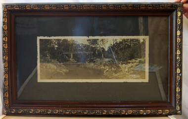
framed black and white photograph, C1920
Boggy Creek Bridge was built in 1916 as part of the Bairnsdale to Orbost extension to the main Gippsland Railway, and is situated in the middle of the township of Nowa Nowa, crossing a steep-sided and well-timbered creek-valley. This section of the line closed in 1987. This item is a pictorial record of the Boggy Creek railway bridge on the East Gippsland line. This bridge plays a major part in the identity and history of the town of Nowa Nowa, since Boggy Creek’s steep sided valley divides the township into two components.A black / white photograph of a bridge across a river in the bush. It is under glass in a brown wooden frame which has gold decorated edges. There appears to be a man sitting on rocks in the right front foreground.on front of photograph - "Nowa Nowa Creek, Gippsland, Victoria, Sears, Copyright"boggy-creek-nowa-nowa east-gippsland-railway bridge-rail -
Stawell Historical Society Inc
Archive - Certificate, Nurses Training Certificate May Booth January 1919, 22-1-1919
May Booth trained at the Pleasant Creek Hospital from around 1915Certificate with picture of Stawell Hospital & Benevolent Asylum - Pleasant Creek HospitalMay Booth Raymond Bell? G Barnes Catherine Wren W M Bellnursing, medical, hospital -
Hume City Civic Collection
Pamphlet
This is a pamphlet about the Emu Bottom Wetlands where the platypus live and swim in Jacksons Creek. The Friends of Emu Bottom Wetlands is chiefly responsible for getting the Platypus Ponds Project going. They were established in 1974 under the auspices of the former Shire of Bulla to advise and assist in the reserves, preservation and protection of the platypus.A Small pamphlet about the local platypus.Platypus Ponds/on/Jacksons Creek/Sunburyplatypus, emu bottom wetlands, emu bottom, shire of bulla, jacksons creek, sunbury, hume city -
 Hume City Civic Collection
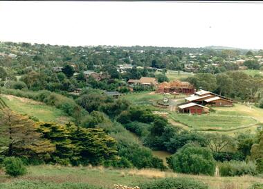
Photograph
Housing development spread to the banks of the Jacksons Creek at the east end of the town in the late 1970s.A coloured landscape photograph overlooking the Jacksons Creek and Sunbury township and showing housing development which is taking place on the horse shore bend also known as blueberry island on the opposite creek bank.jacksons creek, blueberry island, george evans collection -
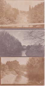 Clunes Museum
Photograph
THREE PHOTOGRAPHS OF THE CLUNES CREEK TAKEN AT THE BRIDGE OR NEARBYPOST CARDS OF CRESWICK CREEK TAKEN BESIDE THE TOWN OF CLUNES VICTORIA AUSTRALIAlocal history, photography, photographs -
 City of Kingston
Photograph - Colour, 1998
The name Mordialloc was derived from the name Moody Yallock, which comes from the Bunurong language. The Bunurong Peoples are the Traditional Owners of this area. The name means “high water” or “high creek”. In 1839, colonial authorities declared the mouth of the creek, and an additional 830 odd acres as an Aboriginal Reserve, although this proclamation was never gazetted. The reserved land included part of the Carrum Carrum Swamp which was abundant with wild life and natural resources. Regular encroachments, including land sales which began in 1863, were made on the land until 1878 when the Reserve was declared closed, and the land was opened up to land sales. Market gardening and suburban house lots quickly began to develop, and Mordialloc became a renowned picnic and holiday site. Mordialloc Creek is a popular bay side destination for local and visitors, and is a site for boating, kayaking, fishing and swimming, along with many other activities.Colour photograph of Mordialloc Creek, looking inland.Small fishing and leisure boats are moored on either side of creek, with a view of the Mordialloc Bridge Hotel in the background.mordialloc, bunurong, traditional owners, suburbs, boats, fishing, waterways, hotel -
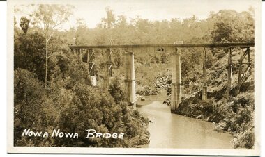 Orbost & District Historical Society
black and white photograph, first half 20th century
This appears to be the Boggy Creek bridge and to have been taken at Nowa Nowa. The Boggy Creek Bridge was built in 1916 as part of the Bairnsdale to Orbost extension to the main Gippsland Railway, and is situated in the middle of the township of Nowa Nowa, crossing a steep-sided and well-timbered creek-valley. This section of the line closed in 1987.This bridge plays a major part in the identity and history of the town of Nowa Nowa, since Boggy Creek’s steep sided valley divides the township into two components. It is part of the East Gippsland Railway line.A black / white photograph / postcard of a tall railway bridge, with concrete pylons in the centre,There is a creek below.on front - bottom left - " NOWA NOWA BRIDGE"boggy-creek-railway-bridge nowa-nowa railway-bridge east-gippsland-railway orbost-bairnsdale-railway -
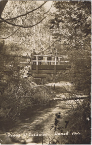 Cockatoo History & Heritage Group
Postcard, Barratt Photo of Men on McBride St Bridge Cockatoo
An early Barratt photo of the Cockatoo Creek, looking towards the McBride St bridge. The four men depicted in the image, look relaxed and are taking in the serenity of the creek below.Dear Florrie, just a card to let you know I haven't quite ? altogether am up here among the ferns and ? It is a lovely place for a quiet holiday the fern gullys are just lovely you can see the Ranges in the distance as blue as the sea. This view is the bridge over Cockatoo creek near the R. Station. As space is short I will close Best Love from ?Original Barratt Photo, of four men standing on the McBride St bridge over the Cockatoo CreekRear of the postcard includes handwritten correspondence in ink, to someone called Florriea. t barratt, postcard, cockatoo creek, cockatoo, views of cockatoo, -
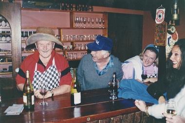
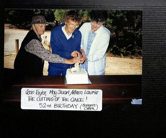 Ringwood and District Historical Society
Photograph, Ringwood CWA 52nd Birthday, cutting the cake at Badger's Creek
Kindly scanned from Ringwood Branch archival collection -
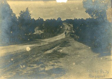 Ringwood and District Historical Society
Photograph, Maroondah Highway, East Ringwood in 1870. Sandy Creek and Sandy Gully. Later dammed to create Ringwood Lake
One sepia photographWritten on back "1870", on front, "Sandy Gully, Ringwood".