Showing 110053 items matching "roads"
-
 Ringwood and District Historical Society
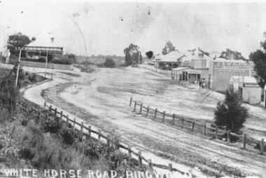
Photograph, Maroondah Highway Central, Ringwood. Whitehorse Road looking west. 1908
Photographs (3 copies- 2 black and white, 1 sepia postcard).Typed below one photograph: "Maroondah Highway Ringwood looking west. Warrandyte Rd coming in from right. 1908." Written on back of another photograph: "Fence divides two levels of road opp Warrandyte Rd looking west. Station Master's house on left." -
 Ringwood and District Historical Society
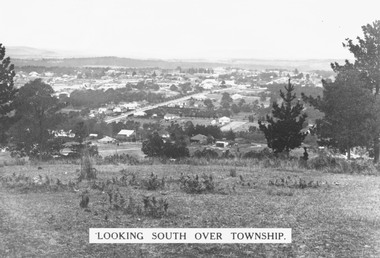
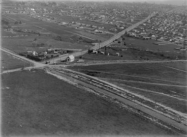
Photograph, Looking south over Ringwood township from Loughnans Hill c1930. Ringwood Street is the main road in the centre
Black and white photograph taken from hill overlooking township of Ringwood. (3 copies)Printed on photograph, "Looking south over township". Typed below photograph, "View from Loughnans Hill c1930. Ringwood Street is the main road in the centre. Old St. Pauls, railway crossing, Methodist church, state school, coolstores, etc. can all be seen". -
 National Wool Museum
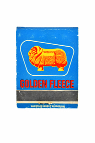
Souvenir - Golden Fleece Matchbook, Hanna Matches, 1960s
Matchbook is a give-away / souvenir for Golden Fleece Petrol and Service Stations. The Golden Fleece Petroleum Company was established by H.C. Sleigh in 1913 importing petroleum from California, and was acquired by Caltex in 1981. The Golden Fleece ram trademark was created in 1951 when Golden Fleece petroleum became a single-brand service. The Golden Fleece ram was based on an actual prize winning merino ram named 'David of Dalkeith' from Boonoke Stud, run by the Falkiner family. Single brand service stations did not appear until the 1950s, and distinctive trademarks and logos were used to differentiate and promote the brands. Golden Fleece is also known to have produced other giveaways / souvenirs (such as games, swap cards, calendars, badges, roadmaps etc) to advertise its brand.Matchbook, containing twenty white-tipped, wooden matches. The matchbook has a fold-over, card cover. The front of the matchbook is blue and is printed with the image of a ram in yellow. Below this is the rough area to strike the matches. The back of the matchbook is yellow and is printed with text in red.GOLDEN FLEECE S. & A. Stolzenburg / P/L. / BLACKWELL SERVICE / STATION / Cnr. / Blackburn & Wellington / Roads / CLAYTON 3168 / PHONE 543-1863 GOLDEN FLEECE / MADE IN AUSTRALIA BY / HANNA MATCH . CONTENTS 20 / For Match Supplies Bladon & Puckridge / Melbourne, Sydney, Brisbane.golden fleece petroleum company h.c. sleigh pty ltd, logo merino: sheep in australian art and design - exhibition (29/07/2000 - 04/02/2001), sheep, matches, souvenirs, petrol, california, caltex, ram -
 Surrey Hills Historical Society Collection
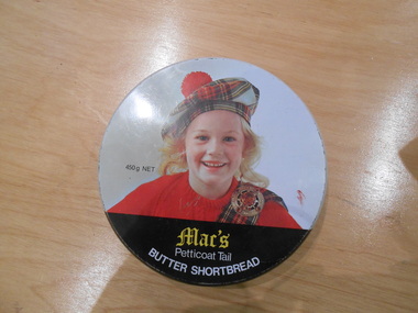
Container - Biscuit tin, Mac's Petticoat Tail Butter Shortbread tin
Mac's Shortbread Co dates its history back to a family bakery in Abbotsford opened in the 1860's producing bread for the goldfields. This eventually became McAlpine's Flour. This business was sold in 1960 and the family then purchased a cake shop, leading to building a biscuit factory. (This is thought to have been the Surrey Hills site). The company outgrew this and moved to Kerang. (Further research required.)This tin is material evidence of the small area of industrial activities that once existed in Surrey Hills.A round tin with a silvered interior and the outside finished in a white enamel paint with the head and shoulders of a blond girl in red jumper, tartan sash and brooch and a tartan tam o'shanter hat.1. Mac's / Petticoat Tail BUTTER SHORTBREAD 450g NET./ BAKED IN AUSTRALIA BY MAC"S SHORTBREAD CO., 1 NORFOLK ROAD, SURREY HILLS, VICTORA AUSTRALIA PHONE 8360333 INGREDIENTS WHEAT FLOUR, CHOICE BUTTER, SUGAR, EVAPORATED MILK BAKING POWDERbakeries, surrey hills, mac's shortbread, norfolk road -
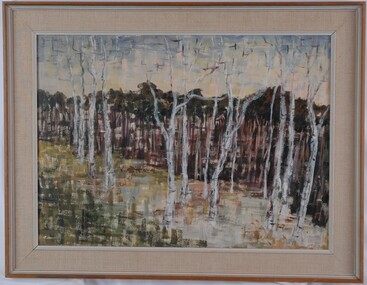 Glenelg Shire Council Cultural Collection
Painting, Renee Arendsen, Dead Wood Forest Mallacoota, 1967
CEMA Art Collection Winner of 1968 Portland Art Society Art Prize for the category Oil or similar medium.The painting depicts several tall, dead trees in the foreground with dense living trees in the background. The foreground is green, white and yellow. The work has an interesting texture created through the use of clearly defined thick paint strokes. This technique is particularly evident in the foreground where it has been used to create the ground from which the dead trees stand. The work has a painted wooden frame with material mount and non-reflective glass.Front: R. ARENDSEN '67 (black, lower right) Back: RENNEE ARENDSEN "DEAD WOOD FOREST, MALLACOOTA" (1968) (typed) Stamp: KATRINA GALLERIES 485 CENTRE ROAD BENTLEIGH, VIC 97-6715 Yellow Sticker: 1967 Handwriting around back of frame.female artists, female artist, landscape, trees -
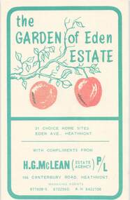 Ringwood and District Historical Society
Flyer, Land Sale Brochure, Garden of Eden Estate, Heathmont. Circa 1966-67
Small buff-coloured leaflet with green print advertising 31 home sites for sale, with summary of subdivision features and services available. Subdivision includes Eden Avenue and Dirkala Avenue, Heathmont. Managing Agents - H.G. McLean P/L, 166 Canterbury Road, Heathmont. (Tel) 877808-9, 8702560, 8422708. £100 or $200 Deposit. Terms £18 or $36 monthly, balance over 4 years. Interest 7% quarterly adjusted. 5% discount for cash. -
 Mont De Lancey
Photograph - Family Photograph, Anker Family, 1886
This photograph pictures the Ankers, one of the founding families of Wandin, Victoria, Australia. It shows the first home they built on their "Tooroonga Park" property, significantly one of the first waves of home in Wandin. It was provided to the Wandin Historical Society and serves as part of Mont de Lancey's extensive digital and physical records of early regional family histories and the history of Victorian settlement.Small A5 black and white photograph of Anker family. Features six adults in 1880s dress. From left to right: Selina Anker (daughter) in long sleeve dark dress, William Anker (father) in slacks and a dark hat, William Anker (son) in dark button up jacket, Emily Anker (daughter) in long sleeve dark dress, Ernest Anker (son) in light button up shirt with tie, and Emma Anker (mother) in patterned dress with skirt ruffles and trumpet sleeves. They stand in front of a light wood house with a brick chimney, surrounded by plants. On the back of the photo is an inscription describing the people and place pictured written by a researcher.ORIGINAL HOME BUILT ON "TOOROONGA PARK" PROPERTY / IN 1886. 55 QUAYLE ROAD WANDIN. / WILLIAM (WILLHEIM) AND EMMA ANKER (nee'HAND)Lilydale. / ELDEST OF THEIR 5 CHILDREN ELIZABETH WORKING AWAY. / Left: SELINA, WILLIAM (Father) WILLIAM (son),EMILY,ERNEST, / EMMA (Mother).tooroonga park, wandin, family photograph, anker family, historical homes, victorian history, regional victoria, farming settlements, yarra valley -
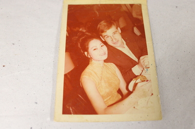 National Vietnam Veterans Museum (NVVM)
Photograph - Original photograph
This item shows Vietnam serviceman Corporal Peter Sims of Headquarters, Australian Force Vietnam (Army Component), 1969-70 on R & R.Faded color photograph of two people-a man and a woman-seated with a crowd in the background. They are formally dressed and there is food on a table in front of the female. The photo is surrounded by a white border.On the back of the photo " Best hotel for R&R approved by the B&R Centre Bangkok Hotel: Tapei, Taiwan. No 76.........Road Taipei Taiwan. R.O.C. Tel 559589-9 (all in blue ink) R&R 1970 see receipt written in black pen.peter sims oam jp., nvvm, sims, r&r, vietnam war -
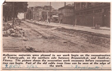 Melbourne Tram Museum
Newspaper, Royal Automobile club of Victoria (RACv), removal of the cable tram track in Victoria Parade, 1963 to 1971
Set of 8 newspaper clippings, mid 1960's concerning traffic control and congestion issues. .1 - Royal auto - 2/1963 - reporting on the removal of the cable tram track in Victoria Parade between Brunswick and Smith St, noting the old cable tram lines. .2 - Royal auto - 1/65 - Photo of Toorak Road Toorak with a tram and parked cars. .3 - Royal auto - 8/64 on Chapel St with W2 324 (route 77, City) showing the impact of parked cars at 8.45am and a motor car trying to squeeze past. .4 - Royal auto - 9/64, Burke Road Camberwell, showing the impact of parked cars and trams. Photo includes SW6 934 (Route 7 Camberwell) .5 - Royal auto - 8/67 - Swanston St near Collins St. .6 - View of Toorak Road, Hartwell, W2 641 (Spencer St, route 74) photo 8/68 by John Shingler. shows the shopping centre. .7 - Royal auto - 9/64 - Johnston St Collingwood and buses. .8 - MMBW Living City Winter 1971 of Kew Junction, peak hour inbound noting the new Eastern Freeway will reduce congestion.Extensive notes on the rear of the photo, see image i2trams, tramways, congestion, traffic control, racv, chapel st, toorak road, victoria parade, cable trams, w2 class, sw6 class, burke road, camberwell, route 77, route 7, swanston st, kew junction, route 74, hartwell, johnston st, buses, tram 324, tram 641, tram 934 -
 Melbourne Tram Museum
Photograph - Digital Image, Kevin O'Reilly, "Kew Burke Rd' looking at the East Kew Tram terminus, c1925
Image from CD (Compact Diskette for use in computers) - see Reg Item 135. Image titled "Kew Burke Rd' on CD, of looking at the East Kew Tram terminus with the city skyline in the background, c1925. Photo published in the Bellcord No. 16, Oct. 2012. From the article with the photograph; The terminus was located at the intersection of High St, Burke, Kilby and Doncaster Roads. We are at the outer edges of Melbourne’s suburbia at the time, unlike the current tram terminus of today. Burke Road, north of Doncaster Road is clearly under construction in preparation for the new river crossing. The vacant block of land in the foreground will remain so for another ten years or so. In 1960 the new Dickens Supermarket was built on this site and the intersection became known locally as Dickens Corner. The narrow track on the left hand side of the photo is Doncaster Road. The tram at the terminus is a straight-sill single trucker of one of the G, K, Q or R classes. It is finished in the late MMTB chocolate and cream livery. A cable grip car body has been placed as a tram shelter at the terminus. The church was subsequently relocated to Francis Street Yarraville where it still stands today as a private residence. Behind the large hedge on the south side of High Street is Smith’s Dairy. Part of this land would be sold to the MMTB for a planned new tram depot Behind the large hedge on the south side of High Street is Smith’s Dairy. Part of this land would be sold to the MMTB for a planned new tram depot but by the early 1960s it was transferred to the Education Department for construction of the Kew High School. The last portion of the dairy closed in the 1970s.trams, tramways, kew, burke rd, east kew, doncaster rd -
 Melton City Libraries
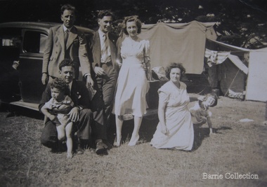
Photograph, Edna and Bon's family camp trip at Apollo Bay, 1948
Wendy Barrie's memories of Apollo Bay The camping trips were a yearly event after the harvest had finished. The trip down to the beach was a much-anticipated event heading out through Parwan and to Geelong leaving behind the hot and dusty plains and our parents relieved to have the hard work of harvesting left behind. The Otways in the distance were reached with great anticipation, Mum in the car and Dad in the Truck ahead of us anxiously winding through the narrow roads and negotiating the hairpin bends and breathing in the cool fresh air of the forest, and keeping an eye out of the log trucks that might come sweeping the corner. The tree ferns with their dripping moisture and the giant trees and the unmistakeable small of the eucalypts. Great excitement was when we caught our first view of the sea from the highest point of the road and then is was the cautious drive the sea level to the sight of the blue ocean with the white of the waves crashing on the rocks and the pristine sand. The water from the Wild Dog and Skenes creek trickling onto the ocean. The tree ferns with their dripping moisture and the giant trees and the unmistakeable smell of the eucalypts. The return journey was usually taken on the Great Ocean Road, it was considered safer to be on the inside of the road. In the early days it was very narrow and passing oncoming cars was taken very cautiously. Landslides and floods sometimes meant we would take the inland route. One year the bridges were washed away and bailey bridges were erected to keep the road open. Rock falls off the cliffs were common Stops on the way home gave us our last chance for our feet in the sand and a swim in the ocean. By the time we reached the hill at Angle Sea the vast blue ocean was behind us and we trekked back through Geelong- Bacchus road and the plains of stubble and the dry grass, and sometimes evidence of burnt patches from a bush fire. The closest we came to a pool at home was the concrete sheep trough at the gate to the work sheds. It was filled with bore water pumped from the nearby windmill. Edna, Bon and their family members at their camp site in Apollo Baylocal identities -
 Eltham District Historical Society Inc
Photograph - Aerial Photograph, Landata, Research, Vic, Apr. 1972
Centred on present day Maroong Drive, Research bounded by Allendale Road to north, Thompson Crescent to south, Eltham College to east and Parsons Road to west. Historic Aerial Imagery Source: Landata.vic.gov.au Aerial Photo Details: Project No :985 Project : MELBOURNE 1972 Run : 26 Frame : 193 Date : 04/1972 Film Type : B/W Camera : RC10 Flying Height : 5700 Scale : 9600 Film Number : 2636 GDA2020 : 37°42'04"S, 145°10'33"E MGA2020 : 339187, 5825794 (55) Melways : 22 F1 (ed. 42)aerial photo, neil webster collection, 1972-04, allendale road, eltham, eltham barrel, eltham college, maroong drive, melway 22f1, parsons road, research (vic.), thompson crescent -
 Eltham District Historical Society Inc
Photograph - Aerial Photograph, Landata, Eltham, Vic, Apr. 1972
Centred on present day Ryans Road at Sandra Avenue, Eltham bounded by Progress Road to north, Brougham Street to south, Bible Street to east and Outlook Crescent to west. Historic Aerial Imagery Source: Landata.vic.gov.au Aerial Photo Details: Project No :985 Project : MELBOURNE 1972 Run : 27 Frame : 48 Date : 04/1972 Film Type : B/W Camera : RC10 Flying Height : 5700 Scale : 9600 Film Number : 2636 GDA2020 : 37°42'41"S, 145°08'38"E MGA2020 : 336392, 5824574 (55) Melways : 21 H4 (ed. 42)aerial photo, neil webster collection, 1972-04, eltham, bible street, brougham steet, melway 21h4, outlook crescent, progress road, ryans road, sandra avenue, montmorency -
 Eltham District Historical Society Inc
Photograph - Aerial Photograph, Landata, Montmorency, Vic, Apr. 1972
Centred on present day Olympic Avenue at Grand Boulevard, Montmorency bounded by Meruka Drive to north, Main Road to south, Main Road to east and Alban Street to west. Historic Aerial Imagery Source: Landata.vic.gov.au Aerial Photo Details: Project No :985 Project : MELBOURNE 1972 Run : 28 Frame : 206 Date : 04/1972 Film Type : B/W Camera : RC10 Flying Height : 5700 Scale : 9600 Film Number : 2635 GDA2020 : 37°43'21"S, 145°07'46"E MGA2020 : 335154, 5823329 (55) Melways : 21 E7 (ed. 42)aerial photo, neil webster collection, 1972-04, eltham, alban street, grand boulevard, lower plenty, main road, melway 21e7, meruka drive, montmorency, olympic avenue -
 Eltham District Historical Society Inc
Document - Property Binder, 736 Main Road, Eltham
Letter 31 August 2004 Eltham District Historical Society to Dragi Natstevski Planning Department Nillumbik Shire Council commenting on Planning Permit Application No 402/2004/02P, Part Shire of Eltham Heritage Study, pages 1440-1243, re brick shop and side dwelling 738 Main Road. Entry in Victorian Heritage Database for 738 Main Road Eltham. Newspaper article: Beacons of light, Marguerite Marshall; Copperline Inaugural Edition, October 2022 Newspaper article: Beacons of light update, Marguerite Marshall; Copperline Edition 7, July 2023main road, eltham, property, houses, shops, zen den cafe, 736 main road eltham -
Glen Eira Historical Society
Letter - Nooralie Private Hospital
Two items about this property: 1/Enquiry from Moyra Cachia seeking information on Nooralie Private Hospital in Ormond. Includes a copy of the reply from Margaret Dunbar that lists information from Sand and McDougal directories from 1942 – 1970 and a reference to information in Caulfield Heritage Vol 1. 2/Email dated 12/02/2013 regarding a photo of a house in Ulupna Road which he says is Nooralie Private Hospital. He is referring to a photo titled Ulupna Road in Jenny O'Donnell's photo album 1972, held by Glen Eira Historical Society.nooralie private hospital, ebenezer baker, hospitals, mcallister c.l, ulupna road, french e.m, ormond, dunbar margaret, cachia moyra, glen eira historical society, nooralie bush hospital -
Glen Eira Historical Society
Article - SHOOBRA ROAD, 62, ELSTERNWICK
Three items on Shoobra Road; 1/Newspaper article dated 02/02/2011, from Melbourne Weekly Bayside, includes three coloured photographs showing renovated home interior and exterior facade. Article notes renovated features and garden highlights, selling agents Biggin and Scott. 2/Handwritten research from Sands and McDougalls edition 1923, 1942, and 1948 giving occupier details, by Claire Barton. 3/Forthcoming auction flyer for 62 Shoobra Road, Elsternwick. Auction date 30/05/2015. Property sold for approximately $2,000,000 by auctioneers HockingStuart.victorian style, elsternwick, shoobra road, fireplaces, ceiling roses, cast iron work, hastings geo.t., hastings mary mrs, verandahs, biggin and scott, real estate agents, water tanks -
 Greensborough Historical Society
Certificate of Title, Supreme Court of Victoria (Probate Division) et al, Certificate of Title Vol. 2567 Fol. 294, Vol. 3134 Fol. 605, 22/05/1895
Title Vol. 2567 Fol. 294 in the name of The Greensborough Estate Company Limited, 164 acres four and a half perches, being part of Crown Portion 17 Parish of Keelbundora, County of Bourke. Dated 22nd May 1895. Northern boundary Greensborough Road (now Grimshaw Street), Southern boundary Nell Street, Eastern boundary Plenty River, Western boundary road (now named McDowell Street); Title Vol. 3134 Fol. 605 in the name of Adolphe Frederic Seelenmeyer, land as described above, LP 4759 and transfers and other instruments to 9 March 1948Folder containing two Certificates of Title (3p. + 9 p.) and twenty pages of miscellaneous documents, including historical summary, brief biography of A. F. Seelenmeyer, two Death Certificates and photocopied extracts from probate documents, as listed in table of contents, ed. by Peter Simmenauergreensborough, greensborough estate company limited, grimshaw street greensborough, plenty river, nell street greensborough, mcdowell street greensborough, adolphe frederic seeley, formerly seelenmeyer, adolfe frederic seelenmeyer -
 Eltham District Historical Society Inc
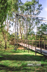
Photograph, Pedestrian suspension bridge over the Yarra River at Lower Plenty, 18 Apr 1998, 1998
Lower Plenty Heritage Excursion included the former monastery of the Blessed Sacrament Fathers, now Odyssey House, and its suspension footbridge across the Yarra River. Odyssey House drug rehabilitation centre in Bonds Road, Lower Plenty is a distinctive landmark, especially when viewed from across the Yarra at Templestowe. It was built in the 1950’s as a seminary for the Blessed Sacrament Fathers. Because of the poor and circuitous road access, a suspension footbridge was built across the river. As well as providing easy access for the priests residents of Templestowe could attend services at the seminary. The bridge is now part of the Yarra Trails system.Roll of 35mm colour negative film, 6 strips Also photographic prints 10 x 15 cmKodak Gold 200-6activities, blessed sacrament fathers, bonds road, bridge, foot bridge, lower plenty, odyssey house, seminary, yarra river -
 Eltham District Historical Society Inc
Photograph, Pedestrian suspension bridge over the Yarra River at Lower Plenty, 18 Apr 1998, 1998
Lower Plenty Heritage Excursion included the former monastery of the Blessed Sacrament Fathers, now Odyssey House, and its suspension footbridge across the Yarra River. Odyssey House drug rehabilitation centre in Bonds Road, Lower Plenty is a distinctive landmark, especially when viewed from across the Yarra at Templestowe. It was built in the 1950’s as a seminary for the Blessed Sacrament Fathers. Because of the poor and circuitous road access, a suspension footbridge was built across the river. As well as providing easy access for the priests residents of Templestowe could attend services at the seminary. The bridge is now part of the Yarra Trails system.Roll of 35mm colour negative film, 6 strips Also photographic prints 10 x 15 cmKodak Gold 200-6activities, blessed sacrament fathers, bonds road, bridge, foot bridge, lower plenty, odyssey house, seminary, yarra river -
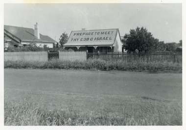 City of Moorabbin Historical Society (Operating the Box Cottage Museum)
Photograph, Black & White, J.Redmore "God Cottage' Bentleigh c1890, c1900
1890 - 1950 This little cottage was located near the corner of Centre Road and Jasper Road East Brighton ( now Bentleigh) between where the Bentleigh RSL and Woolworths Supermarket now stand. Rev.B.Redmore, and his wife, were early members of the Salvation Army Corps, and they went to unusual lengths to proclaim their faith. Texts were hung along the veranda to catch the attention of passers-by and on the iron roof was painted a large sign ' PREPARE TO MEET THY GOD O' ISRAEL' ( The apostrophe is not a misprint.) The Cottage became known locally as The "God Cottage" and was demolished c1950 ( H.Stanley 2005)The 'God Cottage ' with its Biblical texts and large roof sign was an unique feature in East Brighton ( Bentleigh) 1890 - 1950 Black & White photograph showing a small cottage with a large sign painted on the roofBack Handwritten informationredmore reverend b, salvation army, smith j l; smith mary ann, stanley helen, smith vic, chaff cutter, horse drawn carts, toll gates brighton, motor cars 1900, steam engines, early settlers, bentleigh, mckinnon, parish of moorabbin, city of moorabbin, county of bourke, moorabbin roads board, shire of moorabbin, henry dendy's special survey 1841, were j.b.; bent thomas, o'shannassy john, king richard, charman stephen, highett william, ormond francis, maynard dennis, market gardeners, vineyards, orchards -
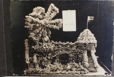 Ballarat Heritage Services
Photograph - Black and White, Butter Sculpture, 1923
The Fisher family lived at Waterloo farm, Smythe's Road, near Ballarat. Alice Russell Shaw the daughter of Jessie Black Hamilton and John Shaw, married Albert Fisher in 1909 and had 10 children by him. They lived at Waterloo farm, Smythe's Road. Alice Russell Fisher (Shaw) was known as 'Queenie' Fisher. This family farmed in the Smythe's area for many years. They produced fine milk and butter. Jean, their second eldest child recalled that when they made the butter sculptures they used plenty of salt so that it wouldn't melt. They won first prizes at the Ballarat Show for the butter sculptures.It is a rare example of home industry and creative endeavour.Two black and white photographs that have been laminated.nonebutter sculpture, smythe's road, smythes, ballarat show, shaw, fisher, hamilton -
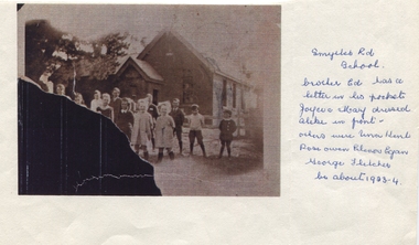 Ballarat Heritage Services
Photograph - Black and White, Smythe's Road School 1923, 1923
The Fisher family lived at Waterloo farm, Smythe's Road, near Ballarat. Alice Russell Shaw the daughter of Jessie Black Hamilton and John Shaw, married Albert Fisher in 1909 and had 10 children by him. They lived at Waterloo farm, Smythe's Road. Alice Russell Fisher (Shaw) was known as 'Queenie' Fisher. This family farmed in the Smythe's area for many years. They produced fine milk and butter. Jean, their second eldest child recalled that when they made the butter sculptures they used plenty of salt so that it wouldn't melt. They won first prizes at the Ballarat Show for the butter sculptures.Photocopy of original photographSmythe's Rd School. Brother Ed has a letter in his pocket. Joyce and Mary dressed alike in front. Others were Una Kent, Rose Owen, Elenor Egan, George Fletcher. Be about 1923-24 fisher, smythe's road school, smythe's road, school, egan, owen, kent, hamilton, shaw, ballarat, waterloo farm -
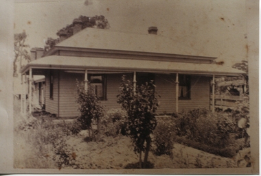 Ballarat Heritage Services
Photograph - Photograph - Black and White, Waterloo Farm, Smythe's Road, uk
The Fisher family lived at Waterloo farm, Smythe's Road, near Ballarat. Alice Russell Shaw the daughter of Jessie Black Hamilton and John Shaw, married Albert Fisher in 1909 and had 10 children by him. They lived at Waterloo farm, Smythe's Road. Alice Russell Fisher (Shaw) was known as 'Queenie' Fisher. This family farmed in the Smythe's area for many years. They produced fine milk and butter. Jean, their second eldest child recalled that when they made the butter sculptures they used plenty of salt so that it wouldn't melt. They won first prizes at the Ballarat Show for the butter sculptures.Llaminated sepia photograph.nonewaterloo farm, fisher, hamilton, shaw, smythe's road, ballarat, farm, farmhouse -
 Ballarat Heritage Services
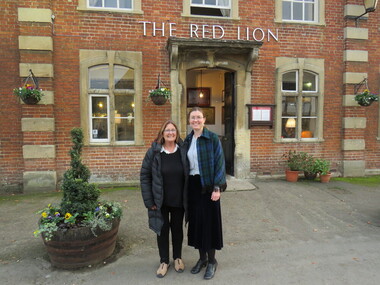
Photograph - Digital photograph, Wayne Phillipson, Peta Knott and Dorothy Wickham at Lacock National Trust Village, United Kingdom, 30/1072016
Lacock was on the main London to Bristol road until the road was re-routed through Chippenham. There are no obvious signs of the 21st century in this National Trust village, except the motor car. It has been run by the National Trust since 1944 and residents are on a lease. The oldest house in the village is King John's Hunting Lodge, parts of which date back to the 13th century. In this village there are buildings from every century since right up until the 18th century. The abbey was founded in 1229 by Ela, Countess of Salisbury. Lacock village and abbey were used as the set in the Harry Potter films.Dorothy Wickham and Peta Knott, formerly of Museums Australia (Vic) currently working as a marine archaeologist in England. Taken at Lacock National Trust Village, United Kingdomdorothy wickham, peta knott, lacock national trust village -
 Numurkah & District Historical Society
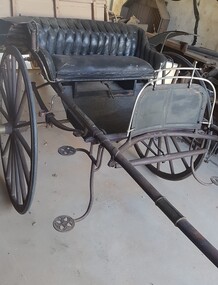
Ladies Jinker
LADIES PONY GIG – circa early 1900’s) The gig was built by T Rose, North Melbourne. Australian coachbuilders adopted American designs and modified these to suit local conditions, eg mudguards added for muddy country roads. As roads improved, lighter and faster designs were made. These gigs were more comfortable than the normal farm cart / town cart (see nearby butcher’s cart), as they were often sprung for comfort rather than carrying heavy weights. (Donated by: Ivan & Gwen Russell, who purchased it from the Hogan Family, Tatura, in 1998) Ivan & Gwen Russell purchased this jinker from the Hogan Family at Tatura in 1998 "The only information we have is that it was built by T. Rose, North Melbourne. As it is in the original Condition we would like to donate it to the Numurkah Historical society to be displayed for others to enjoy. Black-painted ladies jinker (pony gig), with rubber tyred wheels, light hickory shafts, patterned black upholstery on seatT Rose Buildergig, jinker, horse-drawn vehicle, russell -
 Ballarat Tramway Museum
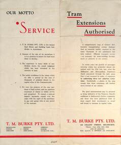
Pamphlet - Real Estate, T M Burke Pty Ltd, "Tram Extensions Authorised", 1936
Wal Jack collected tramway and railway items for his collection. This pamphlet gives details of the Melbourne Public Transport system - rail, tram and bus in late 1936. Issued by T M Burke Pty Ltd of 840 Collins St Melbourne, Real Estate agents, shows the extensive sub-divisions where land was available for purchase and notes the MMTB authorisation of new tram routes. Gives details of the T M Burke services. Routes shown as authorised (16-7-1936) are: Keilor Road Essendon, High St North Balwyn and Hawthorn Road East Brighton. Demonstrates a Real Estate Sales pamphlet.Pamphlet - four colours printed on cream coloured bond paper, folded vertically originally.letter, wal jack, buninyong, railway lines -
![Wal Ives & Bert [Watson] at the outlet of the Kew Main Drain](/media/collectors/550653872162f11fb04854aa/items/61593ef27608a87f688412b1/item-media/61594a5a7608a87f68848c29/item-fit-380x285.jpg) Kew Historical Society Inc
Kew Historical Society IncPhotograph - Wal Ives & Bert [Watson] at the outlet of the Kew Main Drain, c.1900
Connor's Creek is/was one of two major waterways bisecting Kew, both of which empty into the Yarra River. Connor's Creek originates near the grounds of Genazzano FCJ College, which is one of the highest points in Kew. Until the 1930s, this was an open creek until a barrel drain - the Kew Main Drain - was constructed. As the creek ran through Kew it cut across a number of roads the maintenance of which was a continuing concern for Kew Councillors. In August 1864, the Council called for tenders to erect a stone culvert and embankment over Connor's Creek, on Belford-road. This may be the embankment on which the boys are sitting.Original, small photographic positive on card of two boys, identified by the donor as 'Wal Ives and Bert' [Albert Watson] sitting on bluestone capping above an outlet of Connor's Creek. To the left of the boys is a barrel drain which at that stage was the outlet for Connor's Creek near the Yarra River. The retaining wall is constructed of brick. In ink on photo: "Wal & Bert"connors creek -- kew (vic), wal ives, albert watson, belford road, yarra river -- kew (vic.), creeks -- kew (vic.), drains -- kew (vic.) -
Surrey Hills Historical Society Collection
Work on paper - Newspaper article and photo, The Age, Farewell to the sisters, 15 December 1967
Sisters from St Joseph's Convent at 1 Kent Road, Surrey Hills taught at Our Holy Redeemer School in Mont Albert Road from 1902-1967. Formally known as Sisters of St Joseph of the Sacred Heart, they were often called the Josephites or 'Brown Joeys' on account of their brown habits. The order was founded by Saint Mary MacKillop (1842–1909). The order originally transferred to Surrey Hills from South Melbourne where they ran a Home for Destitute Children. The last 3 sisters from Surrey Hills transferred to the Gisborne parish in December 1967. A yellowed newspaper article with a photo depicting two nuns with 4 children, 3 girls and 1 boy facing the sisters but with their backs to the photographer. Background is a brick wall.our holy redeemer school, st joseph's convent, sisters of st joseph of the sacred heart, josephites, brown joeys, gisborne, sister teresa, sister albert, sister edmund, brendan hutchinson, helen fremantle, kelly ryan, marietta urh, school children, uniforms, nuns -
Surrey Hills Historical Society Collection
Work on paper - Program, Our Holy Redeemer Mothers' Club, Our Holy Redeemer Mothers' Club concert program, c 14 December 1967
Sisters from St Joseph's Convent at 1 Kent Road, Surrey Hills taught at Our Holy Redeemer School in Mont Albert Road from 1902-1967. Formally known as Sisters of St Joseph of the Sacred Heart, they were often called the Josephites or 'Brown Joeys' on account of their brown habits. The order was founded by Saint Mary MacKillop (1842–1909). The order originally transferred to Surrey Hills from South Melbourne where they ran a Home for Destitute Children. The last 3 sisters from Surrey Hills transferred to the Gisborne parish in December 1967. A yellowed and grubby paper printed in black detailing 7 songs / dance items performed by students from Prep to Grade 6.1967 handwritten in grey pencil to the right of the printed time and date.our holy redeemer school, st joseph's convent, sisters of st joseph of the sacred heart, josephites, brown joeys, gisborne, sister teresa, sister albert, sister edmund, brendan hutchinson, helen fremantle, kelly ryan, marietta urh, school children, uniforms, nuns