Showing 110054 items matching "roads"
-
 Surrey Hills Historical Society Collection
Work on paper - Program, Our Holy Redeemer Mothers' Club, Our Holy Redeemer Mothers' Club concert program, c 14 December 1967
Sisters from St Joseph's Convent at 1 Kent Road, Surrey Hills taught at Our Holy Redeemer School in Mont Albert Road from 1902-1967. Formally known as Sisters of St Joseph of the Sacred Heart, they were often called the Josephites or 'Brown Joeys' on account of their brown habits. The order was founded by Saint Mary MacKillop (1842–1909). The order originally transferred to Surrey Hills from South Melbourne where they ran a Home for Destitute Children. The last 3 sisters from Surrey Hills transferred to the Gisborne parish in December 1967. A yellowed and grubby paper printed in black detailing 7 songs / dance items performed by students from Prep to Grade 6.1967 handwritten in grey pencil to the right of the printed time and date.our holy redeemer school, st joseph's convent, sisters of st joseph of the sacred heart, josephites, brown joeys, gisborne, sister teresa, sister albert, sister edmund, brendan hutchinson, helen fremantle, kelly ryan, marietta urh, school children, uniforms, nuns -
 Surrey Hills Historical Society Collection
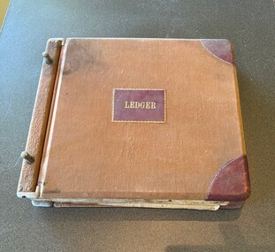
Administrative record - Mitton's Pharmacy Ledger, c 1928
Charles Leslie Mitton (1905-1968) was a pharmacist at 131 Union Road, Surrey Hills from 1933-1968. DOD 30/04/1968. Prior to coming to Surrey Hills, he was a pharmacist in Newmarket (Ref: 1931 electoral roll). He and his wife, Ethel Sylvia Elizabeth Mitton (nee Stevenson) lived at 65 Union Road. They were married in 1933 and had 2 sons and a daughter. He was followed in the business by his son John and daughter Rosalind. See also SHP0015 - Charles Mitton outside his pharmacy; SHP1100 - head and shoulders portrait of Charles Mitton.A ledger with a brown cloth cover, partly stained, with tooled leather corners and a label on the centre of the front cover, both in burgundy leather. The pages are pre-ruled and there is an index at the front. The index includes the account number and the account holder's name. The entries are in blue and occasionally black ink, in a consistent hand. There are a lot of blank pages. The entries include accounts for local doctors for supplies for their practices. Both the front and back covers and the edges of the pages are dirty. There are a handful of blank and filled in accounts loosely held within the ledger.charles leslie mitton, mitton's pharmacy, ledger, 131 union road, pharmacies -
 Surrey Hills Historical Society Collection
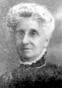
Photograph, Mrs Elizabeth Cumpston, of Mont Albert
Mrs George Cumpston, formerly Miss Elizabeth Newman, of Mont Albert (See also 1289, Mr George William Cumpston) They were married in 1876. He was a commercial traveller. Their property was in the area of Mont Albert between the railway line and Mont Albert Road and Elgar Road. Listed as living in Box Hill in the 1903 electoral roll. The couple were active members of the Box Hill Methodist Church. Photograph from ‘The Jubilee of Box Hill Methodist Church 1883-1933’. By 1909 they had moved to Hawthorn where they lived form many years; later lived in Kew.A black and white photograph of a lady identified as Mrs G. W. Cumpston. She is wearing glasses and has her hair tied back/up possibly in a 'French roll.'(mrs) elizabeth cumpston, (miss) elizabeth newman, box hill methodist church, (mrs) george william cumpston, mont albert -
 Surrey Hills Historical Society Collection
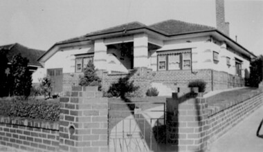
Photograph, 316 Canterbury Road, corner of Essex Road
Mr Walter Sessford Cornhill was born in c1886 in Orsett, Essex; died 2 September 1940 and buried in Box Hill Cemetery (B-069-0028). He was a carpenter. He married Rhoda Fraser (1882-1947). A son John Edmund was a plumber. Daughter Lillian married Charles Frederick Barrow. Walter Cornhill moved from 3 Essex Road to 316 Canterbury Road some tome after 1937. The house passed to Charles Frederick Barrow and wife Lillian and subsequently to Leonard Clement Gangell and his wife Pamela Gangell, nee Barrow.A black and white photograph of an early modern style house built on a corner block. It is built of brick. The upper portion of the house is rendered with occasional brickwork patterning. A low brick fence borders both street frontages.canterbury road, essex road, 1940, early modern style, mr walter sessford cornhill, mrs rhoda cornhill, miss rhoda fraser, mr john edmund cornhill, miss lillian cornhill, mr charles frederick barrow, mrs lillian barrow -
 Surrey Hills Historical Society Collection
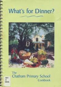
Book, What's for dinner? The Chatham Primary School Cook book, Nov 1999
The book was edited by Clare Nicholls (Coney) and the photo on the front cover shows a view of her then home 'Monserrat' at 26A Wandsworth Road, Surrey Hills. Silky Swallow was a Chinese restaurant at 369/371 Mont Albert Road, Mont Albert. Wild Flower was located at 1 Theatre Place, Canterbury. It was established in c1993 and until 2004 was BYO. Chef's Tandoor is located at It was established in 1991 by Mr Virender Bist (Owner/Chef) who had been head chef with the Taj Group of Hotels. Bollywood on the park is located at 156 Elgar Rd, Box Hill South, opposite Wattle Park. A community cook book with recipes for every occasion. It includes recipes contributed by staff and families plus special recipes from local restaurants and celebrities.chatham primary school, cook book, chef's tandoor, bollywood on the park, wildflower restaurant, silky swallow restaurant, monserrat -
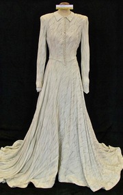 Brighton Historical Society
Dress, Wedding dress, 1948
Louris Holly Larsen-Disney married Percy James White at Melbourne Grammar Chapel on 17 June 1948. In later years the dress was given to an opportunity shop and purchased by Mrs Landells of the Brighton Historical Society. Louris subsequently visited the Society and recognised her dress, and was able to provide BHS with information on it. Also in the Society's collection is a 1950s pink strapless silk chiffon dress worn by Louris, and a wedding photo of Louris taken at her mother and stepfather's home at 53 South Road, Brighton. The couple moved into a house just a few doors down, at 49 South Road.Wedding dress made from silver metallic thread crepe. Fastens down front with small self-covered buttons and loops. Long fitted sleeves fastened with 10 covered buttons and loops. Full bias cut skirt with train.wedding dress, 1940s fashion, louris holly white, percy james white, brighton -
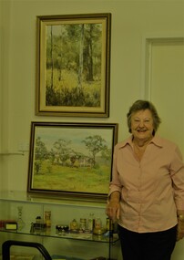
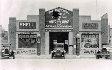 Surrey Hills Historical Society Collection
The Principal Garage at 260 Canterbury Road, Surrey Hills, After 1927
David Staig Jnr established this business in 1927 on the corner of Canterbury Road and Revers Street. He lived at 355 Canterbury Road, one of a series of shops (with living accommodation) owned and built in c1885 by Thomas C Hyde. G Staig (farmer) was the first in the family to occupy this, followed by James Staig (carpenter), then David Staig Snr (blacksmith) and David Staig Jnr. Bill Steiner was the chief mechanic at The Principal Garage; his apprentice Frank Senior eventually bought the business from David Staig and it became Senior's Garage. In 2020 there is a Shell service station and a Coles Express on the site. The Staig family were long-time residents of the area and this photo documents part of their business history. Dave Staig, who established this business, was an early aviator who designed and built his own plane.Black and white photo of a classic 1920's era garage build in brick and render and with 2 petrol bowsers on the curbside, either side of the central garage entrance. Advertising on the facade indicates Shell and Plume motor oils. There are 3 cars positioned in such a way that suggests this may have been a publicity photo. Advertising on the facade indicates that cars could be garaged at the facility and that the proprietor was D. Staig. It also indicates that the business was an agent for The Whippet car, the Willys-Knight car and the Overland car.principal garage, senior's garage, senior's motors pty ltd, garages, redvers street, canterbury road, david staig jnr, bill steiner, frank senior -
 Melton City Libraries
Photograph, Property of the Raleigh family, 1970
Raleighs Road - Property of the Raleigh family descendants of Reiersen family from Norway. Henry and wife Catherine had a small wooden house near Djerriwarrh Creek. Their daughters Catherine married Robinson, and Henrietta married Isaac Robinson of “Creighton” Toolern Vale Road. Henry’s Brother Oliver married Margaret McLean. Their children were, Elsie, Rupert, Lois, Annie, Albert and Olga. She died in September 1986. She was a long term organist at the Presbyterian Church. Lois and Annie were dressmakers ref 100 Years at Melton Isaac and Henrietta - Jeanette Robinson 1985Miss Raleigh's Shop, High Street Meltonpioneer families, local identies -
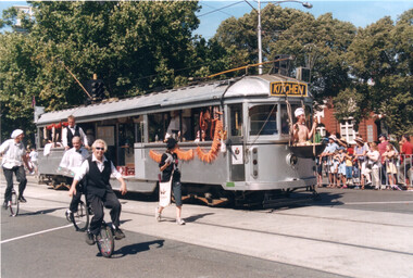 Melbourne Tram Museum
Photograph - Set of 8 colour prints - Moomba trams, c2000
Set of 8 colour prints of trams in a Moomba Parade taken in St Kilda Road. Not known which year - c2000. For the 2002 Program - see Item 1329. Trams were modified for a series of Moomba Events. The last Parade featuring trams was in 2002 and the trams were subsequently disposed of. 1 - Kitchen Tram - could be SW5 795 2 - Antarctica tram, - W6 984 with a friendly whale. 3 - Silk Road tram - SW5 800 4 - Islander Tram SW6 899 5 - Trailer tram 6 - Nirvana tram 7 & 8 - Pedal tram 1042 Yields information about trams used in a Moomba Parade.Set of 8 Colour prints - printed on Kodak Professional paper.trams, tramways, moomba, tram parade, tram 1042, tram 899, tram 800, tram 984, tram 795, sw5 class tram, w6 class, sw6 class, st kilda road -
 Melbourne Tram Museum
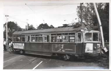
Photograph - Black & White, tram 867 derailed - Riversdale Road, 22/10/1976
The photographs show SW6 tram 867 derailed at the Riversdale Road level crossing on 22/10/1976. The tram ran out of control in Riversdale Road due to the compressor not being turned on before running out to take up a Wattle Park run. This event resulted in trams being rewired so that power to the controller could not be obtained unless the compressor had been turned on. An extract from Electric Traction magazine, Nov. 1976 has been imaged. Tram 331 would have been used in rerailing. See item 7368 for The Herald report of the date.Yields information about the 1967 derailment of tram 867,Set of four Black and White photographs - printed on plain paper and digital copy of a news item.tramways, trams, mmtb, tram 867, rivesdale road, level crossings, derailments, accidents, compressors, tram 331 -
 Eltham District Historical Society Inc
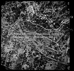
Photograph - Aerial Photograph, Landata, Montmorency / Lower Plenty, Jan. 1973
Centred on 385 Main Road, Lower Plenty bounded by Grand Boulevard, Montmorency to north, Old Eltham Road to south, Bolton Street to east and Panorama Avenue to west. Historic Aerial Imagery Source: Landata.vic.gov.au Aerial Photo Details: Project No :1043 Project : MONTMORENCY Run : 2 Frame : 124 Date : 01/1973 Film Type : B/W Camera : RC8 Flying Height : 2200 Scale : 4000 Film Number : 2722 GDA2020 : 37°43'48"S, 145°07'49"E MGA2020 : 335243, 5822507 (55) Melways : 21 E9 (ed. 42)aerial photo, lower plenty, main road, montmorency, phoebe mason collection, bolton steet, grand boulevard, old eltham road, panorama avenue -
 Orbost & District Historical Society
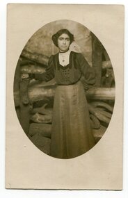
black and white photograph, early 20th century
Ellen Thomas was an Aboriginal woman who lived in Newmerella. George Thomas who lived with his family at Newmerella on Grand View Road until the 1950's. The family was a very well-respected local Aboriginal family.The Thomas family were early residents of Newmerella.A black / white portrait photograph of a lady in a long-sleeved top and long skirt. The photo is oval -shaped and mounted in a light grey card.on back - Ellen Thomasthomas-ellen -
Ringwood and District Historical Society
Tickets, Norwood Secondary College, Karalyka Centre, Ringwood - tickets to 50th Anniversary Dinner 2008, 2008
2 tickets to the 50th anniversary dinner at the Karalyka Centre, Mines Road, Ringwood, on 31-May-2008 donated by Beverley McKeon (past President of Ringwood Historical Society) and foundation pupil Norwood High School 1958.Envelope containing letter, information, two white and purple tickets, and a note from donor. +Additional Keywords: McKeon, Beverley -
 Eltham District Historical Society Inc
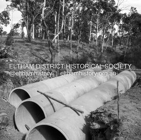
Negative - Photograph, J.A. McDonald, Heidelberg-Kinglake Road, Mar. 1960
Cherry Tree Road Job 56F443 Contractors Wolf and Wood Culverts in place, 3 rows 73” diameter 45-degree skew Looking towards Panton Hill – before trimming ends of pipe March 1960Record of various Shire of Eltham infrastructure works undertaken during the period of 1952-1962 involving bridge and road reconstruction projects, sometimes with Eltham Shire Council Project Reference numbers quoted. It was during this period that a number of significant improvements were made to roads and new bridges constructed within the shire that remain in place as of present day (2022). In many situations, the photos provide a tangible visible record of infrastructure that existed throughout the early days of the Shire. The album was put together by or under the direction of the Shire Engineer, J.A. McDonald.infrastructure, 1960-03, bridge construction, cherry tree road, heidelberg-kinglake road, road construction, shire of eltham -
Glen Eira Historical Society
Article - St. Georges Road, 10, Elsternwick
This file contains four items. Three newspaper items about forthcoming sale of property, includes seven coloured photographs. Handwritten research from Sands and McDougalls by Claire Barton on occupiers of 10 St. Georges Road.st. georges road, elsternwick, kent, house names, lynch jas, white a.a. miss, white chas j., evans ewan c., grave fred k.m., dacre, lepage wm. p., weigall r.e., seamount, jones f.j., copeland osric rev., les naftiaux -
Glen Eira Historical Society
Letter - Pooley Family
Printed history with research from Margaret Dunbar, in return for enquiry from Murray Ellwood about the Pooley and Ellis families of Normanby Road, Caulfield, with associated correspondence, dated 11/08/2010 and 22/07/2010.pooley margaret, normanby avenue, caulfield, dandenong road, inkerman road, towonga, house names, graziers, pooley john, normanby road, malvern, glen eira, ellis margaret, pooley bessie, pooley john ellis, pooley percy charles, pooley edith gwyn, pooley ethel margaret, ellwood murray, glen eira historical society -
Glen Eira Historical Society
Article - Koornang Road, 210, Carnegie
Article dated 07/09/2004 from Caulfield Glen Eira Leader describing 210 Koornang Road and noting forthcoming auction on 02/10/2004. Includes one interior and one exterior colour photograph.carnegie, koornang road, brick houses, auctions -
 Glen Eira Historical Society
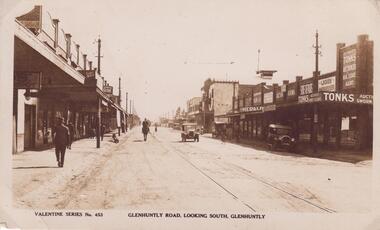
Postcard - Glenhuntly Road, Glen Huntly
A postcard with a black and white photograph of Glen Huntly Road, Glen Huntly. Accompanying handwritten notes transcribe the writing on the back of the post card. The postcard may date from the 1930s though its exact date is unknown.glen huntly road, glen huntly, glenhuntly, valentine series -
 Eltham District Historical Society Inc
Photograph, Jim Connor, Main Road, Eltham, 14 Jan 2017
Eltham Gateway, Alistair Knox Park from near intersection of Main Road and Bridge Street. It was close to this location that the Eltham Obelsik was originally located in 1919 and had to be relocated when roadworks were undertaken to widen the intersection.Tomorrow's history documented todayeltham, jim connor collection, main road, eltham gateway, alistair knox park -
 Greensborough Historical Society
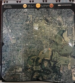
Aerial Photograph, AAM Photographics, Heidelberg AAM1969c 106, 24/11/1991
One of an overlapping series of aerial photographs of the Heidelberg/Greensborough areas in 1991, covering the Simpson Barracks, Greensborough & Viewbank. North boundary Nell Street, East boundary Plenty River, South boundary Lower Plenty Road.Laminated colour aerial photographsimpson barracks, greensborough, viewbank -
 Greensborough Historical Society
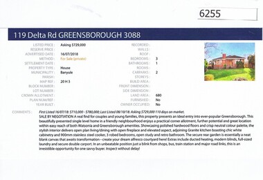
Advertising Leaflet, Barry Plant Greensborough, 119 Delta Road Greensborough, 16/07/2018
Real estate advertisement for 119 Delta Road Greensborough, a 3 bedroom house. Originally listed by Barry Plant, this house was sold 09/03/2019 for $670,000 by Jellis Craig. Previous sales: April 2013 $450,000.Real estate advertisement black text and colour photographdelta road greensborough -
Greensborough Historical Society
Memoir, Recollections by Vera Lay, 1955o
Vera Lay worked in the building known as Marble Hall (situated on the corner of Carter Street (now Para Road) and Main Street. She recalls many of the people and places that made up Main Street Greensborough in the 1950s.A primary source recollection of Greensborough in the mid-20th century.2 typed pages, illustration.vera lay, marble hall, main street greensborough, june hall -
 Greensborough Historical Society
Photograph - Digital Image, June Hall with paintings by Doug Hall, 16/02/2017
GHS member June Hall is photographed with 2 paintings by her late husband Doug Hall. June donated these paintings to the Greensborough Historical Society. One of the paintings if of Oldstead Farm house that was sited at Oldstead Road Greensborough..Paintings are of the local area.Digital copy of colour photographsgreensborough historical society, june hall nee evans, doug hall -
 Eltham District Historical Society Inc
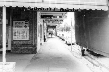
Photograph, Shopping centre, Main Road, Eltham, February 1968, Feb 1968
Main Road shops from midway between Luck and Pryor Streets, looking south along the east side. Includes Browne's Self Service, Delicatessen, Dairy Queen, Commonwealth Bank, Mac's Meats and Thompson's Chemist.In February 1968 an unknown person took a series of photos from the Eltham Hotel at Pitt Street heading north along Main Road through the shopping centre to just north of Elsa Court covering the length of the section of Main Road which was duplicated shortly thereafter. Shows the condition and environment of the streesscape of Main Road, Eltham immediately prior to the duplication between Pitt Street and Elsa Court through the shopping centre. Also shows a number of shops and businesses that operated at that time.Black and white photographduplication, eltham, main road, shopping centre, thompson's pharmacy, mac's meats, delicatessen, dairy queen, commonwealth bank, browne's self service -
 Eltham District Historical Society Inc
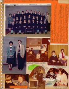
Photo album, Eltham Christian School, Nyora Road, Eltham 1981-1984
One of several pages of a magnetic photo album relating to the staff, students and activities of the Eltham Christian School which operated as part of the Eltham Christian Church at Nyora Road, Eltham. See also entries for each photograph.Page from photo albumeltham christian school, nyora road -
 Eltham District Historical Society Inc
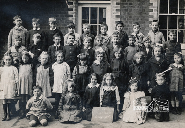
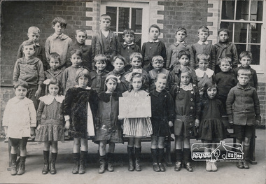
Photograph, Grade IIB, Yarra Park State School No.1406, c.1928, 1928c
Yarra Park State School No.1406 (also known as Yarra Mews) was located at 1055 Punt Road, East Melbourne. It was built 1874 - 1877. Its current use is residential appartments. It is listed in the Victorian Heritage Database. yarra park state school no. 1406, schools, yarra park, yarra mews, class photo, east melbourne, state school no. 1406 -
 Eltham District Historical Society Inc
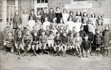
Photograph, Grade IIC, Yarra Park State School No.1406, c.1928, 1928c
Yarra Park State School No.1406 (also known as Yarra Mews) was located at 1055 Punt Road, East Melbourne. It was built 1874 - 1877. Its current use is residential appartments. It is listed in the Victorian Heritage Database. yarra park state school no. 1406, schools, yarra park, yarra mews, class photo, east melbourne, state school no. 1406 -
 Eltham District Historical Society Inc
Photograph, Grade 3B, Yarra Park State School No.1406, c.1928, 1928c
Yarra Park State School No.1406 (also known as Yarra Mews) was located at 1055 Punt Road, East Melbourne. It was built 1874 - 1877. Its current use is residential appartments. It is listed in the Victorian Heritage Database. yarra park state school no. 1406, schools, yarra park, yarra mews, class photo, east melbourne, state school no. 1406 -
 Kiewa Valley Historical Society
Maps - Kiewa Valley Parish Maps x3 and Kiewa Area Planimetric Map x1
Planimetric maps are 2 dimensional representations of the Earth's surface, showing the location and spatial arrangement of features such as roads, buildings, and bodies of water. The parish maps show the occupiers with leases or licences of the land. These are updated by the Department of Lands regularly. The names of early settlers of the Kiewa Valley occupying land by lease or licence are shown. Many of these familie's descendants still live in the Kiewa Valley.1. Kiewa Area Planimetric Map (photo) 2. Wermatong, County of Bogong Parish Map 3. Mulllindolingong, County of Bogong Parish Map 4. Mullagong, County of Bogong Parish Map All black and white kiewa valley. parish maps. land owners -
 Eltham District Historical Society Inc
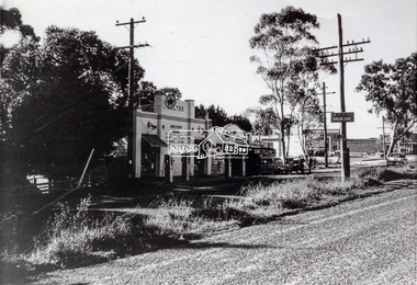
Photograph, Main Road, Lower Plenty at intersection of Old Eltham Road
View looking north across the main road towards the Lower Plenty shops showing the Lower Plenty Garage and store which was later developed into a Caltex service station, since demolished and replaced by a new Aldi supermarket.Black and white print Roll of 35mm colour negative film, 5 of 7 strips Kodak CP100 5094 and associated print Roll of 35mm black and white negative film, 3 strips Ilford FP4 and associated print Roll of 35mm colour negative film, 2 strips Kodak CP100 5094 and associated printaldi, caltex service station, lower plenty, lower plenty garage, lower plenty shops, main road, old eltham road, shops