Showing 63766 items matching " houses"
-
 Eltham District Historical Society Inc
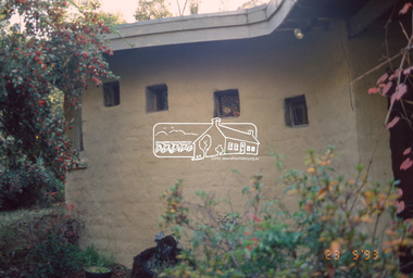
Slide - Photograph, Busst house, cnr of Kerrie Crescent and Silver Street, Eltham, 23 May 1993
... houses ...Opposite No. 11 Kerrie Crescent, (actually 71 Silver street), a 1948 Knox designed mudbrick, with a delightful inglenook fireplace. Additional bedrooms have been added on the top verandah; up the narrow stairs a concrete bath The 1993 Eltham Heritage Tour was enjoyed by a busload of members of the Historical Society on a fine, calm day, Sunday May 23rd. Between 10.00 am and 4.30 pm, except for a brief lunch stop at the Eltham Living and Learning Centre, members passed about thirty places of local interest and others recommended for the Historic Buildings Register and the Register of the National Estate. A number of significant trees and buildings were also highlighted along with the opportunity to explored some of the properties.35mm colour positive transparency (1 of 24) Mount - Kodak Kodachromeactivities, shire of eltham historical society, heritage excursion, eltham, houses, mudbrick, busst house, kerrie crescent, silver street -
 Eltham District Historical Society Inc
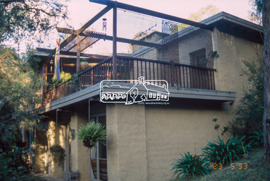
Slide - Photograph, Busst house, cnr of Kerrie Crescent and Silver Street, Eltham, 23 May 1993
... houses ...Opposite No. 11 Kerrie Crescent, (actually 71 Silver street), a 1948 Knox designed mudbrick, with a delightful inglenook fireplace. Additional bedrooms have been added on the top verandah; up the narrow stairs a concrete bath The 1993 Eltham Heritage Tour was enjoyed by a busload of members of the Historical Society on a fine, calm day, Sunday May 23rd. Between 10.00 am and 4.30 pm, except for a brief lunch stop at the Eltham Living and Learning Centre, members passed about thirty places of local interest and others recommended for the Historic Buildings Register and the Register of the National Estate. A number of significant trees and buildings were also highlighted along with the opportunity to explored some of the properties.35mm colour positive transparency (1 of 24) Mount - Kodak Kodachromeactivities, shire of eltham historical society, heritage excursion, eltham, houses, mudbrick, busst house, kerrie crescent, silver street -
 Eltham District Historical Society Inc
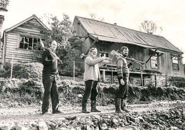
Photograph, Falkiner Cottage, Ely Street Eltham, September 1982, 1982
... houses ...Black and white photograph of Falkiner Cottage, Eltham with Shire of Eltham Historical Society members (Ron Smith, Joh Ebeli and Russell Yeoman), September 1982.Black and white photographeltham, early settlers, ely street, falkiner cottage, joh ebeli, maynard cottage, ron smith, houses, russell yeoman -
 Eltham District Historical Society Inc
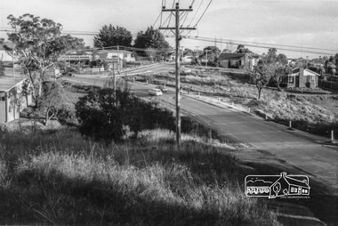
Photograph, Looking south along Para Road at intersection of Alma Street and Lees Road, Lower Plenty, c.July 1967, 1967
... houses ...Old community hall (long wall with row of windows) and Lower Plenty Kindergarten visible at corner of Glenauburn and Para Roads. Packaged in "Filmpro King Size prints Definitely Better EST. 1918" envelope. Pencil notes: 36 shots $2.87 Eltham Shire J. McD and 19/7/67. Alma Street and Kett Street Lower Plenty c.July 1967.Black and white photographalma street, glenauburn road, carisbrook crescent, lees road, lower plenty, lower plenty kindergarten, para road, houses, streets -
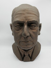 Hume City Civic Collection
Sculpture - Bust, mid 1940's
... houses ...Sculpture was made by a personal friend of the subject in the mid 1940's and displayed in the home of the subject's son, John B. Crosbie until 2001. Bernard Crosbie (subject) was the nephew of Michael Loeman, former Shire of Bulla President and owner of 'Glen Loeman'. Bernard Crosbie and his brother inherited Glen Loeman from Michael Loeman.Bust of a man, Bernard Michael Crosbie, President of Bulla Shire 1936-1937. Made from plaster of Paris (?) painted metallic brown.crosbie, bernard michael, shire presidents, shire of bulla, loeman, michael, glen loeman, houses, george evans collection -
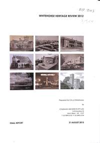 Whitehorse Historical Society Inc.
Book - Heritage Review, Coleman Architects, Whitehorse Heritage Review 2012, 31 August 2015
... Houses ...City of Whitehorse Heritage Review 2012 covers Pre-1945 individual heritage places and former precincts previously identified its Heritage Review 2001 but not assessed for inclusion in the Heritage Overlay.A4, 219 pp. Ringbound final report dated 31 August 2015. Describes heritage values of individual places and precincts in the City of Whitehorse.non-fictionCity of Whitehorse Heritage Review 2012 covers Pre-1945 individual heritage places and former precincts previously identified its Heritage Review 2001 but not assessed for inclusion in the Heritage Overlay.heritage review, 2012, city of whitehorse, buildings, coleman architects, historic buildings, memorials, houses, public buildings -
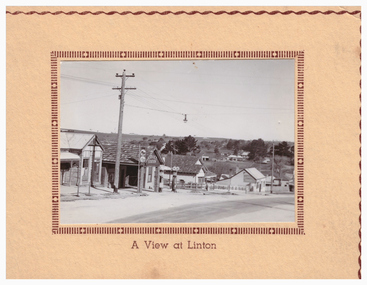 Linton and District Historical Society Inc
Postcard, A View at Linton, Sussex Street, Linton, view to south-east, circa 1940
... Houses ...A very small photograph which has been made into a souvenir/postcard. The photograph is a view of Sussex Street, Linton, looking to the south-east. Buildings which can be seen in the photograph include Bennett's garage/service station, the Bennett family home, and the Edinburgh Bakery. The photograph is glued to a cream-coloured card which has a decorative edge cut into it. A printed border surrounds the photograph, and the words "A View at Linton" are printed underneath it. The card appears to have had the left-hand edge trimmed with scissors.sussex street linton, buildings, shops, houses, bennett's garage, bennett family home, edinburgh bakery, postcards, souvenirs -
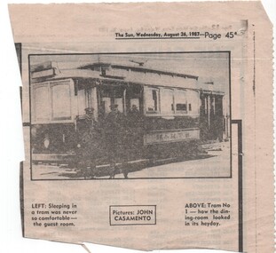 Melbourne Tram Museum
Newspaper, The Sun, Tram No. 1 how the dining-room looked in its heyday", 26/08/1987 12:00:00 AM
... Houses ...Newspaper cutting from The Sun, Wednesday 26/8/1987 of MMTB tramcar No. 1 with two crew standing alongside. Possibly in relation to when No. 1 body was recovered with the caption noting "Tram No. 1 how the dining-room looked in its heyday". See also Reg Item 1356 for another newspaper cutting which identifies the other tram as No. 1. and 1518 for other photos of the building it was located in.trams, tramways, mmtb, pmtt, ferny creek, tramcars, melbourne, houses, tram 1 -
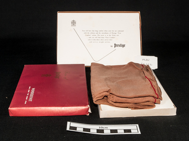 City of Moorabbin Historical Society (Operating the Box Cottage Museum)
Clothing - Clothing, lady's nylon stockings 'Prestige Wonderfoot'', mid 20thC
Prestige Limited was formed in 1922 by George Foletta to manufacture fine silken hosiery. The company had acquired the Atlas Knitting and Spinning Mills Pty Ltd which had been established in 1920 and produced "Prestige hosiery" from 1921. Prestige Limited merged with Holeproof Hosiery Company (Australia) Pty Ltd in 1964. Both were taken over by Pacific Dunlop in 1968. The Prestige name was dropped in 1978/79. George Gotardo Foletta (1892-1973), hosiery and knitwear manufacturer, was born on 30 January 1892 at Northcote, Melbourne, eldest son of Victorian-born parents Henry Gotardo Foletta, a stonemason of Swiss extraction, and his wife Gertrude, née Bright. Henry repaired the depression-ravaged fortunes of his family by starting a successful fancy goods commission-agency.....George persuaded the demoralized board to restructure around a quality-first marketing policy. By 1924, when George A. Bond & Co. Ltd ( Sydney) was liquidated, Prestige was back in the black. About this time the company became the first Australian knitter to make fully-fashioned silk stockings, outselling the best imported brands and giving Prestige dominance of the local hosiery market. With the arrival of British-trained Leslie Gough in 1926, Prestige entered its period of greatest expansion. By 1933 it was spinning its own silk yarn, had diversified into lingerie and commenced business in New Zealand; three years later it was spinning imported rayon filament into hosiery yarn.A pair of unworn lady's brown nylon 'service weight' stockings made by 'Prestige' Pty Ltd. in the original boxBox Lid: House of / Prestige / ‘monogram’ / WONDERSOFT / SERVICE WEIGHT “FOOT COMFORT’ NYLONS. Box inside lid : ‘monogram’ / You will have day long comfort when your feet are cushioned / with the softness and the smoothness of ‘Prestige “Foot Comfort” nylons. The secret is in the Nylon soles / …and you will find these “ Foot Comfort” / soles in ultra sheer, sheer, service sheer / and service weight nylons. / by Prestigeclothing, stockings, nylons, prestige hosiery pty ltd, melbourne, bentleigh, cheltenham moorabbin -
![Scene in the Melbourne Botanical Gardens / [by] Nicholas Caire, circa 1876](/media/collectors/550653872162f11fb04854aa/items/57825c35d0cdd1176ce39a0a/item-media/57825c9fd0cdd1176ce3b5f0/item-fit-380x285.jpg) Kew Historical Society Inc
Kew Historical Society IncPhotograph, Anglo-Australasian Photographic Company, Scene in the Melbourne Botanical Gardens, c. 1876
Nicholas Caire was born on Guernsey in the Channel Islands in 1837. He arrived in Adelaide with his parents in about 1860. In 1867, following photographic journeys in Gippsland, he opened a studio in Adelaide. From 1870 to 1876 he lived and worked in Talbot in Central Victoria. In 1876 he purchased T. F. Chuck's studios in the Royal Arcade Melbourne. In 1885, following the introduction of dry plate photography, he began a series of landscape series, which were commercially successful. As a photographer, he travelled extensively through Victoria, photographing places few of his contemporaries had previously seen. He died in 1918. Reference: Jack Cato, 'Caire, Nicholas John (1837–1918)', Australian Dictionary of Biography.An original, rare photograph from the series 'Views of Victoria: General Series' by the photographer, Nicholas Caire (1837-1918). The series of 60 photographs that comprise the series was issued c. 1876 and reinforced a neo-Romantic view of the Australian landscape to which a growing nationalist movement would respond. Nicholas Caire was active as a photographer in Australia from 1858 until his death in 1918. His vision of the Australian bush and pioneer life had a counterpart in the works of Henry Lawson and other nationalist poets, authors and painters.‘Scene in the Melbourne Botanical Gardens’ : Views of Victoria (General Series) No.38 : Albumen silver photograph | Photo on card with Title and Description on reverse | Mounted 24 x 30 cm; Photo 12 x 17 cm.On Reverse: ‘The subject of this illustration is taken from near the Bridge, which crosses the Garden Lake. The grassy slope in the foreground of the picture is a portion of the North-West or Lower Lawn. Portions of the “Rockery” and the small lake can be seen in the mid-distance, near which is the new Rustic Summer-house. These Gardens are under the management of Mr. Guilfoyle, with about 20 assistant botanists, florists, and general gardeners.’nicholas caire (1837-1918), melbourne botanical gardens, landscape photography - victoria -
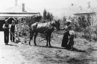 Ringwood and District Historical Society
Photograph, Hunt Residence and family - Bedford Road Ringwood. c1910
Black and white photograph of two men behind a horse and plough. A lady is holding the horse and is accompanied by a little girl. (2 copies)Written on rear of backing sheet: "Rear 8 Bedford Rd. 'Hunt's Orchard' - this now part of Catholic School grounds. Walter hunt (with plough) at rear residence 8 Bedford Rd. Mrs. Hunt holding horse with daughter Laureen (later Mrs. Bob Lynch, Thomas St.). Also Charlie Williams at left. House next door is present (1970) Catholic Convent". -
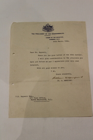 Dandenong/Cranbourne RSL Sub Branch
Memorabilia - Parliamentary letter, Unknown
Contains the original signature of Robert Menzies, then opposition leader. Later to be Prime Minister of Australia.Document addressed to Mr. Knyvett Signed by R.J. Menzies.House of Representatives, The Parliament of the Commonwealth. Leader of the Opposition, Canberra, A.C.T., Dated 28th March, 1946. Dear Mr. Knyvett, Thank you for your letter of the 25th instant. I will give consideration to the proposals you have put before me and I appreciate your very real interest. With all good wishes to you, I am yours sincerely, signed (R.J. Menzies). -
 Kiewa Valley Historical Society
Photo - Bogong Township, March 1944
In 1940 Field Headquarters for the Kiewa Scheme were established at Bogong with office, workshop facilities and accommodation for workmen, staff and some families constructed. (There had been a 'tent camp' on this site in 1939 but was destroyed by bushfires) Construction of accommodation continued until 1947. A total of 40 houses plus a hostel for single staff, post office, police station, medical centre and primary school all with water and sewerage and electricity supply. The staff hostel was known as Kiewa House and is now occupied by the Education Department. Lake Guy was named after Mr. L.T. Guy who was the Resident Engineer in charge of construction work and associated activities on the Kiewa area. He held this position from 1939 to November 1946 when he was transferred to Head Office. The Bogong Township was developed firstly as an accommodation centre (base camp) for construction workers employed under the Kiewa Hydroelectric Scheme. Due to the influx of European workers into the Township the beautification of the immediate surrounds (gardens etc.) had a distinct European flavour. This environment has been very beneficial for tourism in later years. At the completion of the scheme, in the 1960's, the village was opened to public/tourism use. Strict environmental control has not allowed for any extensive redevelopment in tourist accommodation and basically restricted it to the accommodation initially built for the construction workers. Activities such a bike riding, snow skiing, restricted horse riding and bush walking on the Alpine plains and mountains are now a viable part of the Kiewa Valley Tourist Industry. The lake is one of the many water storage reservoirs used to supply the power stations their main power to run the huge turbines generating the final product, electricityBlack and white photograph of Bogong Township taken March 1944Handwritten on the back of photo - Township March '44bogong village, secv -
 Kiewa Valley Historical Society
Photo - Bogong Village Township, October 8, 1946
In 1940 Field Headquarters for the Kiewa Scheme were established at Bogong with office, workshop facilities and accommodation for workmen, staff and some families constructed. (There had been a 'tent camp' on this site in 1939 but was destroyed by bushfires) Construction of accommodation continued until 1947. A total of 40 houses plus a hostel for single staff, post office, police station, medical centre and primary school all with water and sewerage and electricity supply. The staff hostel was known as Kiewa House and is now occupied by the Education Department. Lake Guy was named after Mr. L.T. Guy who was the Resident Engineer in charge of construction work and associated activities on the Kiewa area. He held this position from 1939 to November 1946 when he was transferred to Head Office. The Bogong Township was developed firstly as an accommodation centre (base camp) for construction workers employed under the Kiewa Hydroelectric Scheme. Due to the influx of European workers into the Township the beautification of the immediate surrounds (gardens etc.) had a distinct European flavour. This environment has been very beneficial for tourism in later years. At the completion of the scheme, in the 1960's, the village was opened to public/tourism use. Strict environmental control has not allowed for any extensive redevelopment in tourist accommodation and basically restricted it to the accommodation initially built for the construction workers. Activities such a bike riding, snow skiing, restricted horse riding and bush walking on the Alpine plains and mountains are now a viable part of the Kiewa Valley Tourist Industry. The lake is one of the many water storage reservoirs used to supply the power stations their main power to run the huge turbines generating the final product, electricityBlack and white photograph of Bogong Village which appeared in the Herald Sun newspaper on October 8, 1946. Page 13Handwritten on the back - Town of Bogong on a rugged mountain slope above Lake Guy. State Electricity Committee workers on the Kiewa Hydro Electric scheme live here in all electric homes. Stamped on the back - Copyright Not for reproduction Herald Sun Feature Service Melbourne Australiabogong village; lake guy; kiewa hydro electric scheme -
 Kiewa Valley Historical Society
Postcard - Lake Guy and Bogong Village
In 1940 Field Headquarters for the Kiewa Scheme were established at Bogong with office, workshop facilities and accommodation for workmen, staff and some families constructed. (There had been a 'tent camp' on this site in 1939 but was destroyed by bushfires) Construction of accommodation continued until 1947. A total of 40 houses plus a hostel for single staff, post office, police station, medical centre and primary school all with water and sewerage and electricity supply. The staff hostel was known as Kiewa House and is now occupied by the Education Department. Lake Guy was named after Mr. L.T. Guy who was the Resident Engineer in charge of construction work and associated activities on the Kiewa area. He held this position from 1939 to November 1946 when he was transferred to Head Office. The Bogong Township was developed firstly as an accommodation centre (base camp) for construction workers employed under the Kiewa Hydroelectric Scheme. Due to the influx of European workers into the Township the beautification of the immediate surrounds (gardens etc.) had a distinct European flavour. This environment has been very beneficial for tourism in later years. At the completion of the scheme, in the 1960's, the village was opened to public/tourism use. Strict environmental control has not allowed for any extensive redevelopment in tourist accommodation and basically restricted it to the accommodation initially built for the construction workers. Activities such a bike riding, snow skiing, restricted horse riding and bush walking on the Alpine plains and mountains are now a viable part of the Kiewa Valley Tourist Industry. The lake is one of the many water storage reservoirs used to supply the power stations their main power to run the huge turbines generating the final product, electricityBlack and white photographic postcard of Lake Guy and Bogong Village. Kiewa Hydro electric Project (showing Junction Dam in front)Handwritten on the back of postcard ' Like most of our camps, this looks like something from the Canadian Rockies' Stamped on the back - Valentine's Post Card A genuine photographlake guy, bogong village, secv -
 Kiewa Valley Historical Society
Photo - Bogong Township, September 1953
In 1940 Field Headquarters for the Kiewa Scheme were established at Bogong with office, workshop facilities and accommodation for workmen, staff and some families constructed. (There had been a 'tent camp' on this site in 1939 but was destroyed by bushfires) Construction of accommodation continued until 1947. A total of 40 houses plus a hostel for single staff, post office, police station, medical centre and primary school all with water and sewerage and electricity supply. The staff hostel was known as Kiewa House and is now occupied by the Education Department. Lake Guy was named after Mr. L.T. Guy who was the Resident Engineer in charge of construction work and associated activities on the Kiewa area. He held this position from 1939 to November 1946 when he was transferred to Head Office. The Bogong Township was developed firstly as an accommodation centre (base camp) for construction workers employed under the Kiewa Hydroelectric Scheme. Due to the influx of European workers into the Township the beautification of the immediate surrounds (gardens etc.) had a distinct European flavour. This environment has been very beneficial for tourism in later years. At the completion of the scheme, in the 1960's, the village was opened to public/tourism use. Strict environmental control has not allowed for any extensive redevelopment in tourist accommodation and basically restricted it to the accommodation initially built for the construction workers. Activities such a bike riding, snow skiing, restricted horse riding and bush walking on the Alpine plains and mountains are now a viable part of the Kiewa Valley Tourist Industry. The lake is one of the many water storage reservoirs used to supply the power stations their main power to run the huge turbines generating the final product, electricityBlack and white photograph of Bogong Township taken from Little Arthur fire track. September 1953Faded handwritten inscription on back - Bogong Township taken from Little Arthur fire track. Sept 1953bogong village, secv -
 Kiewa Valley Historical Society
Photo - First Bogong Camp, September 1950
In 1940 Field Headquarters for the Kiewa Scheme were established at Bogong with office, workshop facilities and accommodation for workmen, staff and some families constructed. (There had been a 'tent camp' on this site in 1939 but was destroyed by bushfires) Construction of accommodation continued until 1947. A total of 40 houses plus a hostel for single staff, post office, police station, medical centre and primary school all with water and sewerage and electricity supply. The staff hostel was known as Kiewa House and is now occupied by the Education Department. Lake Guy was named after Mr. L.T. Guy who was the Resident Engineer in charge of construction work and associated activities on the Kiewa area. He held this position from 1939 to November 1946 when he was transferred to Head Office. The Bogong Township was developed firstly as an accommodation centre (base camp) for construction workers employed under the Kiewa Hydroelectric Scheme. Due to the influx of European workers into the Township the beautification of the immediate surrounds (gardens etc.) had a distinct European flavour. This environment has been very beneficial for tourism in later years. At the completion of the scheme, in the 1960's, the village was opened to public/tourism use. Strict environmental control has not allowed for any extensive redevelopment in tourist accommodation and basically restricted it to the accommodation initially built for the construction workers. Activities such a bike riding, snow skiing, restricted horse riding and bush walking on the Alpine plains and mountains are now a viable part of the Kiewa Valley Tourist Industry. The lake is one of the many water storage reservoirs used to supply the power stations their main power to run the huge turbines generating the final product, electricityBlack and white photo of Bogong Village. September 1950Handwritten on the back - 1st Bogong Camp. SEC Kiewa Scheme Sept 1950bogong camp, bogong village, secv -
 Kiewa Valley Historical Society
Photo - Bogong Village Township
In 1940 Field Headquarters for the Kiewa Scheme were established at Bogong with office, workshop facilities and accommodation for workmen, staff and some families constructed. (There had been a 'tent camp' on this site in 1939 but was destroyed by bushfires) Construction of accommodation continued until 1947. A total of 40 houses plus a hostel for single staff, post office, police station, medical centre and primary school all with water and sewerage and electricity supply. The staff hostel was known as Kiewa House and is now occupied by the Education Department. Lake Guy was named after Mr. L.T. Guy who was the Resident Engineer in charge of construction work and associated activities on the Kiewa area. He held this position from 1939 to November 1946 when he was transferred to Head Office. The Bogong Township was developed firstly as an accommodation centre (base camp) for construction workers employed under the Kiewa Hydroelectric Scheme. Due to the influx of European workers into the Township the beautification of the immediate surrounds (gardens etc.) had a distinct European flavour. This environment has been very beneficial for tourism in later years. At the completion of the scheme, in the 1960's, the village was opened to public/tourism use. Strict environmental control has not allowed for any extensive redevelopment in tourist accommodation and basically restricted it to the accommodation initially built for the construction workers. Activities such a bike riding, snow skiing, restricted horse riding and bush walking on the Alpine plains and mountains are now a viable part of the Kiewa Valley Tourist Industry. The lake is one of the many water storage reservoirs used to supply the power stations their main power to run the huge turbines generating the final product, electricityBlack and white photograph of Bogong Village from across Lake Guy. Photo mounted on buff cardbogong village, secv -
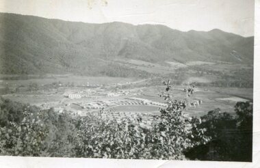 Kiewa Valley Historical Society
Photograph - Mount Beauty from Bogong Hill, 1950
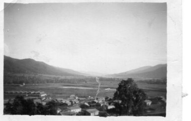
The new State Electricity Commission construction camp at the head of the Kiewa Valley was for workmen on the second power station in the project expected to be the most modern and best equipped in Australia… In contrast to the early Kiewa days of horses and canvas tents, the new camp, with its modern amenities, compared favourably with any country town. Administration of the Kiewa Scheme was moved from Tawonga to Mount Beauty in 1946. The first house in Mount Beauty, in Hollonds Street, was occupied by the co-op store manager from November 1946. The new Mess Hall at Mt Beauty was opened with much ceremony in early November 1946. The houses up to Nelse street were erected from 1946 onward and then the township was extended beyond Nelse Street in 1950. The workmen's camp was enlarged in 1950 to the extent of providing accommodation for a total of 1,200.Shows early construction of the town of Mt. Beauty surrounded by farmland taken in 1950 during the early stages of construction of the Kiewa Hydro electric SystemBlack and white photograph - aerial view of Mt Beauty taken from Bogong Hill. Photograph framed by 6mm white boarder.Handwritten on back of photograph in black ink - Mt Beauty from Bogong Hill 1950 Printed on rear Volox 2428mt beauty, bogong hill, secv -
 Kiewa Valley Historical Society
Photograph - Mount Beauty from second gate. View down Kiewa Valley, 1950
The new State Electricity Commission construction camp at the head of the Kiewa Valley was for workmen on the second power station in the project expected to be the most modern and best equipped in Australia… In contrast to the early Kiewa days of horses and canvas tents, the new camp, with its modern amenities, compared favourably with any country town. Administration of the Kiewa Scheme was moved from Tawonga to Mount Beauty in 1946. The first house in Mount Beauty, in Hollonds Street, was occupied by the co-op store manager from November 1946. The new Mess Hall at Mt Beauty was opened with much ceremony in early November 1946. The houses up to Nelse street were erected from 1946 onward and then the township was extended beyond Nelse Street in 1950. The workmen's camp was enlarged in 1950 to the extent of providing accommodation for a total of 1,200.Shows early construction of the town of Mt. Beauty surrounded by farmland taken in 1950 during the early stages of construction of the Kiewa Hydro electric SystemBlack and white photograph - View from second gate down Kiewa Valley showing early buildings. Photograph framed by 6mm white boarderHandwritten in back of photo in blue ink - View from second gate down Kiewa Valley 1950mt beauty, kiewa valley, secv -
 Kiewa Valley Historical Society
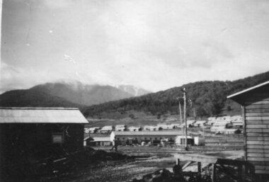
Photograph - Mount Beauty SEC Camp and Town, 1950
The new State Electricity Commission construction camp at the head of the Kiewa Valley was for workmen on the second power station in the project expected to be the most modern and best equipped in Australia… In contrast to the early Kiewa days of horses and canvas tents, the new camp, with its modern amenities, compared favourably with any country town. Administration of the Kiewa Scheme was moved from Tawonga to Mount Beauty in 1946. The first house in Mount Beauty, in Hollonds Street, was occupied by the co-op store manager from November 1946. The new Mess Hall at Mt Beauty was opened with much ceremony in early November 1946. The houses up to Nelse street were erected from 1946 onward and then the township was extended beyond Nelse Street in 1950. The workmen's camp was enlarged in 1950 to the extent of providing accommodation for a total of 1,200.Shows early construction in the town of Mt. Beauty surrounded by hills and farmland, with Mt Bogong in the background. Photo was taken in 1950 during the early stages of construction of the Kiewa Hydro electric SystemBlack and white photograph of Mt Beauty township in 1950 showing original workers buildings. Photograph has a .5cm white border around the photo.Handwritten on back of photograph in blue ink - SEC Camp and Town Mt Beauty 1950mt beauty, secv, mt beauty workmen's camp -
 Kiewa Valley Historical Society
Photograph - Mt Beauty Camp
The new State Electricity Commission construction camp at the head of the Kiewa Valley was for workmen on the second power station in the project expected to be the most modern and best equipped in Australia… In contrast to the early Kiewa days of horses and canvas tents, the new camp, with its modern amenities, compared favourably with any country town. Administration of the Kiewa Scheme was moved from Tawonga to Mount Beauty in 1946. The first house in Mount Beauty, in Hollonds Street, was occupied by the co-op store manager from November 1946. The new Mess Hall at Mt Beauty was opened with much ceremony in early November 1946. The houses up to Nelse street were erected from 1946 onward and then the township was extended beyond Nelse Street in 1950. The workmen's camp was enlarged in 1950 to the extent of providing accommodation for a total of 1,200.Shows early construction in the town of Mt. Beauty surrounded by hills and farmland, with a snow capped Mt Bogong in the background. Photo was taken in approximately 1950 during the early stages of construction of the Kiewa Hydro-electric SystemBlack and white photograph, mounted on corrugated cardboard. Photograph of Mt Beauty townshipHandwritten on back of photograph in blue pen - Permanent loan from Adrian Campan April 96 057-544043mt beauty camp, secv -
 Kiewa Valley Historical Society
Photograph – Set of 3 black and white photographs of Bogong Village circa late 1930's - 1940's during early construction of Lake Guy ( in the foreground), Late 1930's - 1940's
In 1940 Field Headquarters for the Kiewa Scheme were established at Bogong with office, workshop facilities and accommodation for workmen, staff and some families constructed. (There had been a 'tent camp' on this site in 1939 but was destroyed by bush fires) Construction of accommodation continued until 1947. A total of 40 houses plus a hostel for single staff, post office, police station, medical centre and primary school all with water and sewerage and electricity supply. The staff hostel was known as Kiewa House and is now occupied by the Education Department. Lake Guy was named after Mr. L.T. Guy who was the Resident Engineer in charge of construction work and associated activities on the Kiewa area. He held this position from 1939 to November 1946 when he was transferred to Head Office. The Bogong Township was developed firstly as an accommodation centre (base camp) for construction workers employed under the Kiewa Hydroelectric Scheme. Due to the influx of European workers into the Township the beautification of the immediate surrounds (gardens etc.) had a distinct European flavour. This environment has been very beneficial for tourism in later years. At the completion of the scheme, in the 1960's, the village was opened to public/tourism use. Strict environmental control has not allowed for any extensive redevelopment in tourist accommodation and basically restricted it to the accommodation initially built for the construction workers. Activities such a bike riding, snow skiing, restricted horse riding and bush walking on the Alpine plains and mountains are now a viable part of the Kiewa Valley Tourist Industry. The lake is one of the many water storage reservoirs used to supply the power stations their main power to run the huge turbines generating the final product, electricity3 black and white photographs of the Bogong camp area showing the clearing of trees for the construction of the Junction Dam and Lake Guy. Some administration buildings have been constructed, but part of the tent camp can be seen to the right of the photograph in front of the buildings. bogong village; junction dam; lake guy; kiewa hydro electric scheme; secv -
 Eltham District Historical Society Inc
Photograph, Fay Bridge, EDHS Heritage Excursion, Culla Hill, Sweeneys Lane, Eltham, 7 September 2019
September Excursion - Culla Hill Walk Pioneer Eltham farmer Thomas Sweeney (1803 - 1867) named his house, “Culla Hill” after the area in Ireland that he came from. His house, now called “Sweeneys”, remains on a ridge line overlooking the Yarra River. It is recorded that Thomas Sweeney did well out of carting potatoes and other supplies to the various gold fields such as Bendigo, McIvor (Heathcote), Mount Alexander and Beechworth. Culla Hill is now the name of the road providing access to subdivided lots of the former Sweeney property. The Culla Hill walk will start at the corner of Kent Hughes and Lavender Park Roads, Eltham (Melway ref. 22 A9) at 2.00pm on Saturday 7th September. - EDHS Newsletter No. 247 August 20192019-09-07, activities, culla hill, eltham, eltham district historical society, fay bridge collection, heritage excursion, sweeneys lane -
 Eltham District Historical Society Inc
Photograph - Digital copy of photograph, Former Griffith family home, Banoon Road, Eltham, c.1955
Former family home of Mr. Frederick Eldred (Fred) Griffith in the 1950s, where present day Griffith Park is situated on the Yarra River at Eltham. Fred Griffith was also a Councillor (1945, 1951-1953) and former Shire President (1951) of the Shire of Eltham. Faye Walker (nee Harris) spent her first ten years living in the house. She recalls "there was a huge tin shed to the rear but toward the east of the house. I assume this is what people were thinking of when reference was made to the ‘’packing shed’. When I was small in the 50s, the shed was no longer being used for fruit packing but by the Griffith family as storage. Many of the pear trees remained but were no longer a commercial venture. We used to sneak up to the shed to read the National Geographic Magazines."griffith park, eltham, frederick eldred griffith, faye walker (nee harris) collection -
 Glen Eira Historical Society
Document - PRENTICE STREET, 14, ELSTERNWICK
Four real estate campaigns for this property: 1/Newspaper ad dated 08/10/2003, includes one coloured photograph, and gives brief details on house features. 2/Newspaper ad dated 01/09/2006, includes two coloured photographs. Ad gives brief details on house features. 3/Newspaper real estate ads Melbourne Weekly Bayside dated 17/11/2010 and 24/11/2010 with similar front exterior colour photo and different rear exterior and interior photos. Details of property identical. 4/Real estate ad hand-dated 26/11/2016 with colour photos of front and rear plus 2 interior photos. Brief details stated for architect-transformed Edwardian home.prentice street, verandahs, godridge john, elsternwick, timber houses, edwardian styles, caulfield, stefanis angelos, glenhuntly road, stavraki s bill, newton todd, ashton daniel, real estate agents -
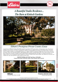 Eltham District Historical Society Inc
Document - Brochure, The Barn at Kinloch Gardens; Elders Real Estate sales material, 1998
Description by Elders Real Estate: A Beautiful Studio Residence: The Barn at Kinloch Gardens Eltham's prestigious Private Country Estate A special part of Eltham's heritage. Beautifully situated on grounds of 1750 square metres with panoramic views, this dramatic building on three levels is converted to a ? office residence from the original farm house of the Kinloch Estate. The main level, 21 metres in length, is a soaring galleried space of 17 squares of flexible living and working areas, extensive storage spaces and private courtyard. Centrally located within Kinloch's landscaped grounds. The Barn is a romantic focal point of a unique enclave of ten contemporary house designed by Graeme Gunn and Ian Jelbart, the cultural mix of old and new confirms the value and reputation of this exclusive private estate. Digital file only; created from scan undertaken by EDHS of item on loanarthur street, elders real estate, eltham, houses, jelbart property, kinloch gardens, real estate agent, the barn, woodridge estate -
 Greensborough Historical Society
Photograph, Main Road bridge looking to township of Greensborough, 1929c
View of Main Street Greensborough from Partington's Hill including Plenty River bridge and Marble Hall on corner of Carter Street (now Para Road) and Main Street. This view of Greensborough Park shows the old pan toilets, the hawthorn fence line and the rather undeveloped roadside area of the park. Looking up Main Street we see the old Chapman house at the corner of Poulter Avenue and some newer houses below this. The stone river bridge appears to be only a single lane wide and the road approaching the bridge is unsealed. The rail bridge shows evidence of soot from steam trains and at the extreme left of picture the two concrete buildings indicate the line had been electrified. This occurred in 1923. Sparse housing is seen in the Flintoff Street and Grimshaw Street area.Part of a collection of photographic enlargements of views of Greensborough in the early 1900s.Black and white enlargement of photographic imagemain street greensborough, marble hall, greensborough railway, chapman house, greensborough park, poulter avenue greensborough, carter street, para road -
 Kiewa Valley Historical Society
Photograph from Lake Guy, Bogong Village, Scene from shores of Lake Guy to Mountain range, 1930s to 1950s
In 1940 Field Headquarters for the Kiewa Scheme were established at Bogong with office, workshop facilities and accommodation for workmen, staff and some families constructed. (There had been a 'tent camp' on this site in 1939 but was destroyed by bushfires) Construction of accommodation continued until 1947. A total of 40 houses plus a hostel for single staff, post office, police station, medical centre and primary school all with water and sewerage and electricity supply. The staff hostel was known as Kiewa House and is now occupied by the Education Department. Lake Guy was named after Mr. L.T. Guy who was the Resident Engineer in charge of construction work and associated activities on the Kiewa area. He held this position from 1939 to November 1946 when he was transferred to Head Office.The Bogong Township was developed firstly as an accommodation centre (base camp) for construction workers employed under the Kiewa Hydroelectric Scheme. Due to the influx of European workers into the Township the beautification of the immediate surrounds(gardens etc.) had a distinct European flavour. This environment has been very beneficial for tourism in later years. Strict environmental control has not allowed for any extensive redevelopment in tourist accommodation and basically restricted it to the accommodation initially built for the construction workers. Activities such a bike riding, snow skiing, restricted horse riding and bush walking on the Alpine plains and mountains are now a viable part of the Kiewa Valley Tourist Industry. The lake is one of the many water storage storage reservoirs used to supply the power stations their main power to run the huge turbines generating the final product, electricityThis black and white photograph shot from the shores of Lake Guy toward the mountain range of the Victorian Alps details the early construction of the construction worker's accommodation of the Bogong Village. The paper is of 200gms and is not photographic paper and can be assumed to be a reproduction of an original photobogong village circa 1930 to 1950, kiewa hydro-electricity scheme, victorian alpine region mid 1900s -
 Kiewa Valley Historical Society
Photograph of Lake Guy and Bogong Village, Lake Guy and Bogong Village, Approx. 1945
In 1940 Field Headquarters for the Kiewa Scheme were established at Bogong with office, workshop facilities and accommodation for workmen, staff and some families constructed. (There had been a 'tent camp' on this site in 1939 but was destroyed by bushfires) Construction of accommodation continued until 1947. A total of 40 houses plus a hostel for single staff, post office, police station, medical centre and primary school all with water and sewerage and electricity supply. The staff hostel was known as Kiewa House and is now occupied by the Education Department. Lake Guy was named after Mr. L.T. Guy who was the Resident Engineer in charge of construction work and associated activities on the Kiewa area. He held this position from 1939 to November 1946 when he was transferred to Head Office.This photograph is an excellent historical record of Bogong Village in about 1945. It shows the layout of the town in the fairly steep terrain, the workmen's camp between the houses and the lake foreshore, the Commissioner's Lodge on the hill behind the Village, the walkway through the dam wall can be seen to the left of the spillway, the dam is on spill and note damage to the large trees is still evident from the 1939 bush fires. The Commissioner's Lodge was lost in the 2003 fires and the camp buildings were in service until 1962, when they were removed and the site converted into a public picnic area with lawns and gardens.A Black and white photograph"Lake Guy and Bogong" hand written on back of photograph.kiewa, accommodation, lake, dam, bogong