Showing 18548 items matching "w"
-
 Eltham District Historical Society Inc
Photograph - Aerial Photograph, Landata, Eltham, Vic, Apr. 1963
Centred on present day Zig Zag Road and Main Road, Eltham bounded by Maroondah Aqueduct to north, Thompson Crescent and Arthur Street to south, Parsons Road to east and Glen Park Road and Banks Road to west. Historic Aerial Imagery Source: Landata.vic.gov.au Aerial Photo Details: Project No :486 Project : MELBOURNE (1963) PROJECT Run : 5 Frame : 59 Date : 04/1963 Film Type : B/W Camera : RC8 Flying Height : 5100 Scale : 9600 Film Number : 1805 GDA2020 : 37°42'24"S, 145°08'52"E MGA2020 : 336716, 5825114 (55) Melways : 21 J3 (ed. 42)aerial photo, neil webster collection, eltham, 1963-04, arthur street, banks road, glen park road, maroondah aqueduct, melway 21j3, parsons road -
 Eltham District Historical Society Inc
Photograph - Aerial Photograph, Landata, Eltham, Vic, Apr. 1963
Centred on present day Floriston Grove, Eltham bounded by Maroondah Aqueduct to north, Thompson Crescent and Diosma Road to south, Research Shops to east and Glen Park Road and Park West Road to west. Historic Aerial Imagery Source: Landata.vic.gov.au Aerial Photo Details: Project No :486 Project : MELBOURNE (1963) PROJECT Run : 5 Frame : 60 Date : 04/1963 Film Type : B/W Camera : RC8 Flying Height : 5100 Scale : 9600 Film Number : 1805 GDA2020 : 37°42'24"S, 145°09'29"E MGA2020 : 337622, 5825128 (55) Melways : 22 B3 (ed. 42)aerial photo, neil webster collection, eltham, 1963-04, diosma road, floriston grove, maroondah aqueduct, melway 22b3, park west road, research (vic.), research shops -
 Eltham District Historical Society Inc
Photograph - Aerial Photograph, Landata, Lower Plenty, Vic, Apr. 1963
Centred on present day Old Eltham Road near Araluen Centre, Lower Plenty bounded by Cromwell Street to north, Yarra River to south, Main Road at Mount Pleasant Road to east and Panorama Avenue to west. Historic Aerial Imagery Source: Landata.vic.gov.au Aerial Photo Details: Project No :486 Project : MELBOURNE (1963) PROJECT Run : 7 Frame : 231 Date : 04/1963 Film Type : B/W Camera : RC8 Flying Height : 5100 Scale : 9600 Film Number : 1805 GDA2020 : 37°44'03"S, 145°07'56"E MGA2020 : 335420, 5822027 (55) Melways : 21 F10 (ed. 42)aerial photo, neil webster collection, 1963-04, araluen, cromwell street, eltham, lower plenty, main road, melway 21f10, mount pleasant road, old eltham road, panorama avenue, yarra river -
 Eltham District Historical Society Inc
Photograph - Aerial Photograph, Landata, Eltham, Vic, Apr. 1963
Centred on present day Eltham Lower Park bounded by Brougham Street to north, Yarra River and Fitzsimons Lane Bridge to south, Main Road at Kent Hughes Road to east and Bolton Street to west. Historic Aerial Imagery Source: Landata.vic.gov.au Aerial Photo Details: Project No :486 Project : MELBOURNE (1963) PROJECT Run : 7 Frame : 232 Date : 04/1963 Film Type : B/W Camera : RC8 Flying Height : 5100 Scale : 9600 Film Number : 1805 GDA2020 : 37°44'03"S, 145°08'33"E MGA2020 : 336329, 5822040 (55) Melways : 21 H10 (ed. 42)aerial photo, neil webster collection, 1963-04, bolton steet, brougham steet, eltham, eltham lower park, fitzsimons lane bridge, kent hughes road, melway 21h10, yarra river -
 Eltham District Historical Society Inc
Photograph - Aerial Photograph, Landata, Eltham North, Vic, Apr. 1972
Centred on present day Eltham North reserve near Eltham North Primary School, Eltham North bounded by Allendale Road to north, Bellevue Road to south, Zig Zag Road and Beard Street to east and Ryans Road to west. Historic Aerial Imagery Source: Landata.vic.gov.au Aerial Photo Details: Project No :985 Project : MELBOURNE 1972 Run : 26 Frame : 190 Date : 04/1972 Film Type : B/W Camera : RC10 Flying Height : 5700 Scale : 9600 Film Number : 2636 GDA2020 : 37°41'52"S, 145°08'52"E MGA2020 : 336705, 5826102 (55) Melways : 11 J12 (ed. 42)aerial photo, neil webster collection, 1972-04, allendale road, beard street, bellevue road, eltham, eltham north, eltham north reserve, melway 11j12, ryans road, zig zag road, eltham north primary school -
 Eltham District Historical Society Inc
Photograph - Aerial Photograph, Landata, Research, Vic, Apr. 1972
Centred on present day Main Road, Research near Maroondah Aqueduct and Eltham College bounded by Allendale Road to north, Research-Warrandyte Road to south, Swipers Gully Training Restaurant to east and Reynolds Road to west. Historic Aerial Imagery Source: Landata.vic.gov.au Aerial Photo Details: Project No :985 Project : MELBOURNE 1972 Run : 26 Frame : 194 Date : 04/1972 Film Type : B/W Camera : RC10 Flying Height : 5700 Scale : 9600 Film Number : 2636 GDA2020 : 37°42'07"S, 145°11'07"E MGA2020 : 340015, 5825692 (55) Melways : 22 H1 (ed. 42)aerial photo, neil webster collection, 1972-04, allendale road, eltham college, main road, maroondah aqueduct, melway 22h1, research (vic.), research-warrandyte road, reynolds road, swiper's gully -
 Eltham District Historical Society Inc
Photograph - Aerial Photograph, Landata, Eltham, Vic, Apr. 1972
Centred on present day Diamond Creek Trail at the Eltham Leisure Centre bounded by Central Park to north, Main Road at Falkiner Street to south, MacMahon Ball Paddock to east and Grand Boulevard at Buena Vista Drive to west. Historic Aerial Imagery Source: Landata.vic.gov.au Aerial Photo Details: Project No :985 Project : MELBOURNE 1972 Run : 28 Frame : 207 Date : 04/1972 Film Type : B/W Camera : RC10 Flying Height : 5700 Scale : 9600 Film Number : 2635 GDA2020 : 37°43'25"S, 145°08'20"E MGA2020 : 335985, 5823223 (55) Melways : 21 G7 (ed. 42)aerial photo, neil webster collection, 1972-04, eltham, buena vista drive, central park, diamond creek trail, eltham leisure centre, falkiner street, grand boulevard, macmahon ball paddock, main road, melway 21g7 -
 Eltham District Historical Society Inc
Photograph - Aerial Photograph, Landata, Eltham, Main Road; Mt Pleasant Rd to Railway Rd, Dec. 1945
Centred on Main Rd and Henry St, Eltham bounded by Railway Road to north, Mount Pleasant Road at Main Road to south, top of the hill in Arthur Street to east and Karingal Drive at Sherbourne Road to west. Historic Aerial Imagery Source: Landata.vic.gov.au Aerial Photo Details: Project No :65 Project : MELBOURNE AND METROPOLITAN PROJECT NO. 2 Run : 8 Frame : 70 Date : 01/1951 Film Type : B/W Camera : EAG9 Flying Height : 12200 Scale : 12000 Film Number : 1419 GDA2020 : 37°43'06"S, 145°08'45"E MGA2020 : 336589, 5823811 (55) Melways : 21 J6 (ed. 42)aerial photo, eltham, main road, henry street, arthur street, bolton street, eltham-yarra glen road, neil webster collection, 1951-01, dave lyon house, ernie andrew house, karingal road, melway 21j6, mount pleasant road, railway road -
 Glen Eira Historical Society
Letter - Centre Road, 758, Bentleigh East
A two page duplicate copy of a typed letter, dated 04/03/1977 addressed to William Lasica and Co Solicitors from W V Scott detailing inspection and valuation of the property at 758 Centre Road, Bentleigh East. The letter includes handwritten notes, dated 21/08/1978, concerning a telephone conversation discussing the potential demolition of the building on the property and the building of a medical centre. The file also includes one page of undated and unattributed handwritten working notes, concerning the valuation of the relevant property. The file also includes one page of undated, unattributed handwritten notes, outlining sales of properties on Centre Road, Bentleigh East.centre road, bentleigh east, east bentleigh, hospitals, east bentleigh community health centre, k m p holdings pty ltd, land values, timber houses, health establishments -
 Eltham District Historical Society Inc
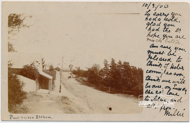
Postcard, Post Office, Eltham, 1906, 1906
Postcard sent to Mrs W. Heber Green (Adelaide May Green), 10 March 1906 From Millie. William Heber Green was a lecturer according to the 1909 Electoral Roll. Looking south along Maria Street (Main Road) from intersection with Bridge Street, Eltham, c.1906. Burgoyn'e Post Office on left. The footpath was about 2 feet above the road level. Horse and cart near the entrance to John Street. Webster's house was on the the northeast corner of Pitt and Maria (Main Road) and the verandah was over the footpath. Watson's Hotel on southeast corner, Fountain Hotel on southwest corner and Morrison's house on the northwest corner. (Doug Orford) Used post card with notePostage stamp and post marked Eltham Victoriaadelaide may green, bridge street, burgoyne, eltham, fountain hotel, main road, maria street, millie, morrison home, pitt street, post office, watsons hotel, webster home, william heber green -
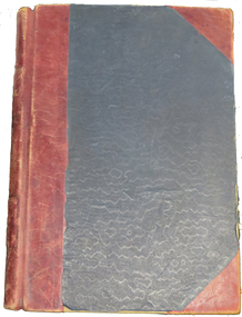
 Ballarat Clarendon College
Book, Cook's voyages Vols 1-2
H P MacKenzie donated these books to the Ballarat College library in the year that his wife donated money to the school in memory of her parents, Mr and Mrs W Weatherly. The money was used to purchase book shelves and furnishings for a new library and a call was made to old collegians and membersof the school community to donate books to stock the new library. Harold Ponsonby MacKenzie served on Ballarat College council 1925 - 1946. His sons Alastair and Kenneth also attended the school. Alastair served on councils also - BC Council 1957-73, BCC Council 1974-80. Alastair's daughter Mia attended the school 1983-4. Large cloth bound books with gold lettering and patterns on spine and coversBook plate inside front cover: Crest / Ballarat College Library / PRESENTED BY / Eng Com H D MacKenzie 1936 / ...h-p-mackenzie, harold-ponsonby-mackenzie, gladys-dalziel-mackenzie, william-weatherly, weatherly-library, library, 1936, alastair-mackenzie, mia-mackenzie -
 Phillip Island and District Historical Society Inc.
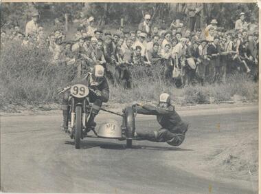
Photograph, 1950 approx
Donated by J W Gliddon with his comments on back of photograph. Taken when motorbike and car racing were run around the roads on Phillip Island. Racing first came to Phillip Island in 1927 in the form of a 200 mile road race for motorcycles on a circuit encompassing Cowes and Rhyll. In the next year, a shorter rectangular course, again on public roads, was used for the running of what became the first Australian Grand Prix. Eight successive Australian Grand Prix were run on this course before the race was moved elsewhere. Finally in 1935, racing was discontinued and Phillip Island lapsed into the tranquility and peacefulness of its quiet country and beach atmosphere.Black & White photograph of motorcycle riders on bike and sidecar. Crowd watching at the side of the road. See Historical Information for more detail re motorcycle racing on Phillip Island.On back: "This picture could become historically interesting as machines and methods change. It was taken about the year 1950. Perhaps earlier." motor cycle racing -
 Phillip Island and District Historical Society Inc.
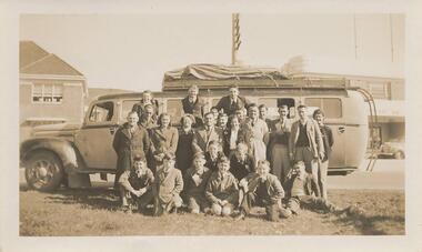
Photographs, Phillip Island Band's visit to Tasmania, 1947
Five photographs of the Phillip Island Band going on a social visit to Tasmania in 1947. Boys and parents. Names of people in photograph 333-01 and 333-02: Back row: Charlotte Cleeland, Arthur Murdoch, Alan Cleeland. Centre row: Tom Westley (bandmaster), Jim Broadbent, Joan Westley, Nan Hislop, Tom Cartwright, Wally Goodall, Des Cartwright, Wally?, Jessie Cartwright, Ken Clark (Tasmanian Bus Driver), Les Bain, Stan Walton, Doug Morrison, Mary Broadbent. Front row: Arbie Broadbent, W McNair, John Bennett, Kevin Wagner, Bill Broadbent, Ian Matthews, Robert Cleeland, Bob Cartwright.Five photographs of the Phillip Island Band going on a social visit to Tasmania in 1947. Boys and parents. 333-01 - Black & White photograph of the Band in front of the Bern Denham bus in Cowes. 333-02 is an enlargement of 333-01. 333-03 - Black & White photograph of the Band in the bus ready for departure to Tasmania. 333-04 - Black & White photograph of the Band in front of a Monument possibly in Tasmania. 333-05 - Black & White enlargement of 333-04. phillip island band, kevin findlay -
 Eltham District Historical Society Inc
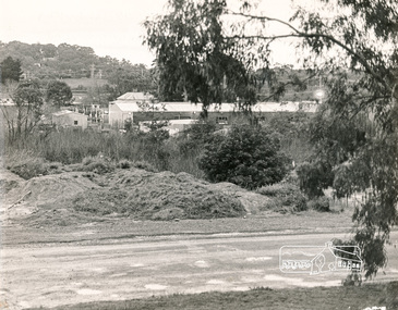
Photograph, N. J. Tillings Timber Factory, 15 June, 1975, 15/06/1975
Edge of brick building part of the light industrial area including N. J. Tillings Timber Factory, Brougham Street, Eltham. This is one of 7 B/W 8x10 inch photos with notes on back by Dick Crichton. Accompanying letter from Florence Chrichton 2013 : "Originally sent to Shire of Eltham Engineer, Mr. McDonald. [These photographs were part of their campaign to the Shire of Eltham in 1975] claiming that the zoning regulations were being breached by the occupants of various factories in the nearby light industrial zone [Brougham Street, Eltham] - to the detriment of those living in adjoining residential zones, and that, despite .. earlier objections and complaints, nothing was done about it." 1 black and white photograph printed with white border on three sidesindustrial estate, brougham street, eltham, 1975, bolton street, dick crichton, n.j. tillings, timber factory, shire of eltham -
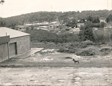
 Eltham District Historical Society Inc
Photograph, N. J. Tillings Timber Factory, 15 June, 1975, 15/06/1975
Piles of dirt alongside dirt road, part of the light industrial area including N. J. Tillings Timber Factory, Brougham Street, Eltham. This is one of 7 B/W 8x10 inch photos with notes on obverse by Dick Crichton. Accompanying letter from Florence Chrichton 2013 : "Originally sent to Shire of Eltham Engineer, Mr. McDonald. [These photographs were part of their campaign to the Shire of Eltham in 1975] claiming that the zoning regulations were being breached by the occupants of various factories in the nearby light industrial zone [Brougham Street, Eltham] - to the detriment of those living in adjoining residential zones, and that, despite .. earlier objections and complaints, nothing was done about it." 1 black and white photograph printed with white border on three sidesInscribed on back: "View from residential premises in Brougham Street. Trees in foreground will soon be lost due to making of the main drain by M.M.B.W.. Photograph shows topographical features of the valley and how sound travels upwards and outwards to residential zones surrounding." industrial estate, brougham street, eltham, 1975, bolton street, dick crichton, n.j. tillings, timber factory, shire of eltham -
4th/19th Prince of Wales's Light Horse Regiment Unit History Room
Medal, Order of the British Empire (Civil)
Most Excellent Order of the British Empire Awarded by Sovereign of the United Kingdom Type Order of Chivalry Motto For God and the Empire Eligibility British nationals or anyone who makes an impact for the UK Awarded for A national order of chivalry Status Currently constituted Sovereign Queen Elizabeth II Grand Master Prince Philip, Duke of Edinburgh Principal Commander Sovereign Grades (w/ post-nominals) Knight/Dame Grand Cross (GBE) Knight/Dame Commander (KBE/DBE) Commander (CBE) Officer (OBE) Member (MBE) Established 1917 Precedence Next (higher) Royal Victorian Order Next (lower) Varies, depending on rankMiniature medal with ribbon-medal, obe -
 Eltham District Historical Society Inc
Folder, Jorgensen, Justus
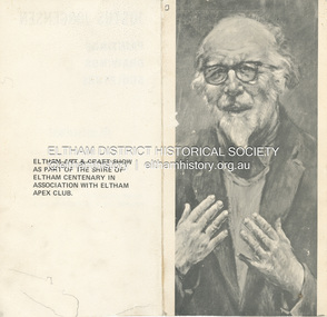
1. Exhibition Invitation: Justus Jorgensen; Paintings, Drawings, Sculpture, A Retrosepctive Exhibition, to be opened by Professor W. MacMahon Ball, Montsalvat, Hillcrtest Avenue, Eltham , Saturday 3rd April (1971) at 11.00 a.m.. (Eltham Art and Craft show as part of the Shire of Eltham Centenary in association with Eltham Apex Club). 2. Mini Biography: Justus Jorgensen (1894-1975) 3. An ode to the trendies, John March, The Age, Saturday, August 12, 1978, p15 - a review of a visit to Montsalvat and poetry reading during the 1978 Eltham Fesitval. Includes picture of Justus Jorgensen and cartoon sketch by Harper (?) 4. Mini Biography: Justus JorgensenFolder of information on Justus Jorgensen, artist and architect, Montsalvat.justus jorgensen, artist, eltham apex club, eltham art & craft show, exhibition, invitation, montsalvat, shire of eltham centenary, william macmahon ball, biography, 1978, david campbell, dorothy hewett, eltham festival, frank kellaway, poetry reading, poets, rosemary dobson, eltham cemetery, lily jorgensen -
 Federation University Historical Collection
Photograph - Photograph - Colour, Alan Scarlett, Traralgon War Memorial, 2015, 2015
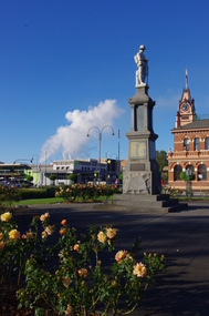
The Traralgon War Memorial was originally erected in memory of the fallen soldiers of World War One. The Gippsland Times of 01 March 1923."On Sunday a memorial that has been erected in memory of the fallen soldiers of the district was unveiled. The ceremony was performed by Mr G. H.Wise, and addresses were delivered by Mr W West, M.LA. the president of the shire and local clergymen. The memorial, which cost £700, and contains 54 names of young men who made the supreme sacrifice is a lifesized figure of an Australian soldier and is made white Italian marble. It now commemorates Australian servicemen and women who have served in all wars and conflicts. It was re-dedicated on 11 November 1999.Colour photograph of the Traralgon War Memorial with surrounding townscape. The war memorial features a life sizes sculpture of an Australian world war soldier wearing a slouch hat. Loy Yang Power stations are evident in the background. Traralgon Post office on right foreground. traralgon, world war one, anzac day, loy yang, traralgon post office, anzac centenary -
 Federation University Historical Collection
Book - Book - Register, Ballarat Junior Technical School Register Book, 1913-1943, 1913-1943
The Ballarat Junior Technical School opened in 1913 as a division of the Ballarat School of Mines. The first location was the Dana Street Primary School, and the first principal was Albert W. Steane. In 1921 a custom built building was erected on the grounds of the Ballarat School of Mines. A number of the students enlisted in the Australian Infantry Forces (AIF) during 1913, 1914. They were Robert Borradale, Albert Burge, Howard Bennett, Norman Carmichael, Reginald Crick, Herbert Collins, Frances Davis, Arthur Dixon, Frank Edwards, George Gilbert and Sydney Townsend. Frances Davis was killed while serving. Those who enlisted have been remembered with an Honour Board with their names. This is at SMB.Book is charcoal blue cloth on hard cover with red leather spine and corners. End papers are brown/grey "stone" patterned thick gloss paper. Name of school and type of book stamped on gold on the spine - REGISTER, BALLARAT JUNIOR TECHNICAL SCHOOL" It is the first Ballarat Junior Technical School Roll Book. The book includes handwritten names, age, date of birth, address, school last attended, grade, qualifications, date of entry, cause, results and remarks. The remarks includes workplaces, whether they joined the AIF, etc. Records A.I.F. service. 309 Trompf, Percival Albert 344 Moy, Richard James E. 376 Serjeant, Robert M 380 Tippett, Edgar John T. 447 Skilbeck, John E.Book plate on inside of front cover. "BERRY, ANDERSON & CO Bookbinder Lydiard St and Dana St Ballarat" Reordering information and reference number given - 24176ballarat school of mines, ballarat junior technical school, roll book, enrolments, albert steane, a.w. steane, albert w. steane, trades, apprentices, world war one, alchin saddlers, ronaldson and tippett, newport workshops, ballarat brewery, cutter coachbuilder, ballarat woollen mill, jelbart's foundry, eureka pottery, robson's leadlighter, long's biscuit factory, a.i.f. service, enrolment register, ballarat junior technical school enrolments, john dufler, robert borradale, albert burge, howard bennett, norman carmichael, reginald crick, herbert collins, frances davis, arthur dixon, frank edwards, george gilbert, sydney townsend -
Mount Evelyn History Group
Book Railways of the Yarra Valley, Nick Anchen, Railways of the Yarra Valley, 2010
Railways of the Yarra Valley takes you on a nostalgic journey back in time to when the Victorian Railways branch lines and the ingenious bush tramways were the lifeblood of isolated rural communities. This book examines the much loved Warburton and Healesville railways, along with the fascinating Powelltown, Britannia Creek and Warburton tramway systems, all of which were instrumental in making the Yarra Valley Victoria�s most prosperous timber region. Featuring a superb array of colour and b&w images, most never before published, complimented by interesting and informative text, plus stories from those who saw and worked the lines. Soft bound, 96 pages. (from website)Coloured cover soft back book -
Mount Evelyn History Group
Book Railways of the Yarra Valley, Nick Anchen, Railways of the Yarra Valley, 2010
Railways of the Yarra Valley takes you on a nostalgic journey back in time to when the Victorian Railways branch lines and the ingenious bush tramways were the lifeblood of isolated rural communities. This book examines the much loved Warburton and Healesville railways, along with the fascinating Powelltown, Britannia Creek and Warburton tramway systems, all of which were instrumental in making the Yarra Valley Victoria�s most prosperous timber region. Featuring a superb array of colour and b&w images, most never before published, complimented by interesting and informative text, plus stories from those who saw and worked the lines. Soft bound, 96 pages. (from website)Coloured soft back book -
 Port Melbourne Historical & Preservation Society
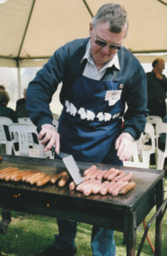
Photograph - Launch of History of a Street Precinct, 25 Sep
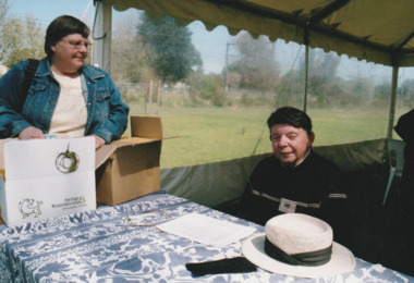
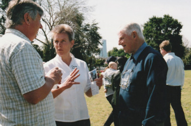
In 2005, members of the PMH&PS undertook a study of the residents of the houses in a Port Melbourne street precinct from the 1880s to 1960. The area is bounded by Evans Street, the E side of Bridge Street, S side of Williamstown Road, Farrell Street both the E & W sides plus the section of Ross Street between Farrell and Bridge and the part of Derham Street between Farrell and Bridge. The resulting map and an interactive CD won the Best Community Research, Registers & Records project at the 2007 Victorian Community History Awards. The project was launched on the railway reserve near the corner of Evans & Farrell streets. Jack BOLT is cooking with Ken TURNER in the background.Jack Bolt cooking sausages at the launch of the History of a Street Precinct25/9/05 Jack Bolt 11jack bolt, ken turner, history of a street precinct -
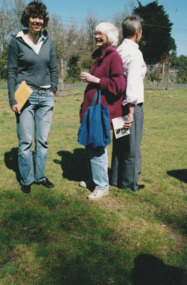
 Port Melbourne Historical & Preservation Society
Photograph - Launch of History of a Street Precinct, 25 Sep
In 2005, members of the PMH&PS undertook a study of the residents of the houses in a Port Melbourne street precinct from the 1880s to 1960. The area is bounded by Evans Street, the E side of Bridge Street, S side of Williamstown Road, Farrell Street both the E & W sides plus the section of Ross Street between Farrell and Bridge and the part of Derham Street between Farrell and Bridge. The resulting map and an interactive CD won the Best Community Research, Registers & Records project at the 2007 Victorian Community History Awards. The project was launched on the railway reserve near the corner of Evans & Farrell streets. LL - R - unknown, Pat GRAINGER, Graham BRIDE.Pat GRAINGER, Graham BRIDE at the launch of the History of a Street Precinct project. 25/9/05 Not Known, Pat Grainger, Graham Bridepat grainger, graham bride, history of a street precinct -
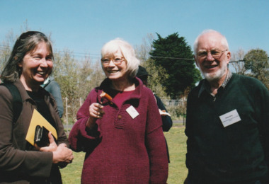
 Port Melbourne Historical & Preservation Society
Photograph - Launch of History of a Street Precinct, 25 Sep
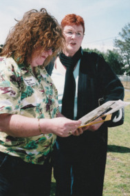
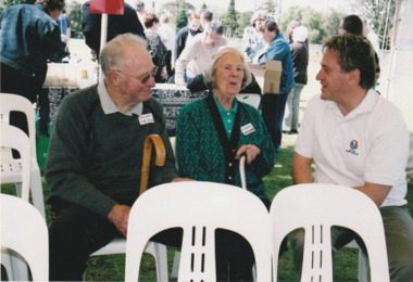
In 2005, members of the PMH&PS undertook a study of the residents of the houses in a Port Melbourne street precinct from the 1880s to 1960. The area is bounded by Evans Street, the E side of Bridge Street, S side of Williamstown Road, Farrell Street both the E & W sides plus the section of Ross Street between Farrell and Bridge and the part of Derham Street between Farrell and Bridge. The resulting map and an interactive CD won the Best Community Research, Registers & Records project at the 2007 Victorian Community History Awards. The project was launched on the railway reserve near the corner of Evans & Farrell streets. L- R - Natica SCHROEDER, Pat GRAINGER, Janet BOLITHO.Three members of the PMHPS the launch of the History of a Street Precinct25/9/05 Natica Schroeder, Pat Grainger, Janet Bolithohistory of a street precinct, pat grainger, natica schroeder, janet bolitho -
 Port Melbourne Historical & Preservation Society
Photograph - Launch of History of a Street Precinct, 25 Sep
In 2005, members of the PMH&PS undertook a study of the residents of the houses in a Port Melbourne street precinct from the 1880s to 1960. The area is bounded by Evans Street, the E side of Bridge Street, S side of Williamstown Road, Farrell Street both the E & W sides plus the section of Ross Street between Farrell and Bridge and the part of Derham Street between Farrell and Bridge. The resulting map and an interactive CD won the Best Community Research, Registers & Records project at the 2007 Victorian Community History Awards. The project was launched on the railway reserve near the corner of Evans & Farrell streets. L- R - Val POWER, Jim POWER.Two members of the PMHPS the launch of the History of a Street Precinct25/9/05 Val Power, Jim Powerhistory of a street precinct, val power, jim power -
 Port Melbourne Historical & Preservation Society
Photograph - Launch of History of a Street Precinct, 25 Sep
In 2005, members of the PMH&PS undertook a study of the residents of the houses in a Port Melbourne street precinct from the 1880s to 1960. The area is bounded by Evans Street, the E side of Bridge Street, S side of Williamstown Road, Farrell Street both the E & W sides plus the section of Ross Street between Farrell and Bridge and the part of Derham Street between Farrell and Bridge. The resulting map and an interactive CD won the Best Community Research, Registers & Records project at the 2007 Victorian Community History Awards. The project was launched on the railway reserve near the corner of Evans & Farrell streets. L- R - Robyn ?, Maralyn KOBELTMaralyn & Robin at the launch of the History of a Street Precinct25/9/05 Robyn ?, Maralyn Kobelthistory of a street precinct, maralyn kobelt -
 Port Melbourne Historical & Preservation Society
Photograph - Launch of History of a Street Precinct, 25 Sep
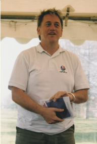
In 2005, members of the PMH&PS undertook a study of the residents of the houses in a Port Melbourne street precinct from the 1880s to 1960. The area is bounded by Evans Street, the E side of Bridge Street, S side of Williamstown Road, Farrell Street both the E & W sides plus the section of Ross Street between Farrell and Bridge and the part of Derham Street between Farrell and Bridge. The resulting map and an interactive CD won the Best Community Research, Registers & Records project at the 2007 Victorian Community History Awards. The project was launched on the railway reserve near the corner of Evans & Farrell streets. Darren Ray, Mayor of City of Port Phillip.City of Port Phillip mayor, Cr Darren Ray at the launch of the History of a Street Precinct25/9/05 Darren Ray Mayor CoPPhistory of a street precinct, darren ray -
 Port Melbourne Historical & Preservation Society
Photograph - Launch of History of a Street Precinct, 25 Sep
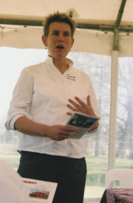
In 2005, members of the PMH&PS undertook a study of the residents of the houses in a Port Melbourne street precinct from the 1880s to 1960. The area is bounded by Evans Street, the E side of Bridge Street, S side of Williamstown Road, Farrell Street both the E & W sides plus the section of Ross Street between Farrell and Bridge and the part of Derham Street between Farrell and Bridge. The resulting map and an interactive CD won the Best Community Research, Registers & Records project at the 2007 Victorian Community History Awards. The project was launched on the railway reserve near the corner of Evans & Farrell streets. Janet BOLITHO, former mayor of City of Port Phillip.Former City of Port Phillip mayor, Janet Bolitho, at the launch of the History of a Street Precinct25/9/05 Janet Bolithohistory of a street precinct, janet bolitho -
 Port Melbourne Historical & Preservation Society
Photograph - Launch of History of a Street Precinct, 25 Sep
In 2005, members of the PMH&PS undertook a study of the residents of the houses in a Port Melbourne street precinct from the 1880s to 1960. The area is bounded by Evans Street, the E side of Bridge Street, S side of Williamstown Road, Farrell Street both the E & W sides plus the section of Ross Street between Farrell and Bridge and the part of Derham Street between Farrell and Bridge. The resulting map and an interactive CD won the Best Community Research, Registers & Records project at the 2007 Victorian Community History Awards. The project was launched on the railway reserve near the corner of Evans & Farrell streets. L - R - Unknown, Norah HOWARD, Mayor Darren RAY.CoPP mayor and PMHPS members at the launch of the History of a Street Precinct25/9/05 Not known, Norah Howard, Darren Ray, Mayorhistory of a street precinct, darren ray, norma howard -
 Port Melbourne Historical & Preservation Society
Photograph - Launch of History of a Street Precinct, 25 Sep
In 2005, members of the PMH&PS undertook a study of the residents of the houses in a Port Melbourne street precinct from the 1880s to 1960. The area is bounded by Evans Street, the E side of Bridge Street, S side of Williamstown Road, Farrell Street both the E & W sides plus the section of Ross Street between Farrell and Bridge and the part of Derham Street between Farrell and Bridge. The resulting map and an interactive CD won the Best Community Research, Registers & Records project at the 2007 Victorian Community History Awards. The project was launched on the railway reserve near the corner of Evans & Farrell streets. L - R - Unknown, Janet BOLITHO, Glen STUART.CoPP mayor and PMHPS members at the launch of the History of a Street Precinct25/9/05 Not known, Janet Bolitho, Glen Stuarthistory of a street precinct, janet bolitho, glen stuart