Showing 2474 items matching " township"
-
 Hume City Civic Collection
Photograph, late 1990s
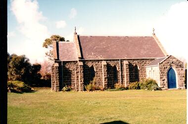
St. Mary's Anglican Church at Bulla was originally built on the outskirts of Bulla township in 1858. In the early 1970s it was moved to its present site to make way for the flight path at the newly constructed Tullamarine Airport. The former site was on the corner of Oaklands and Sunbury Roads and is covered with vegetation. The church was designed by Thomas Taylor.A profile view of the west side of St. Mary's Anglican Church at Bulla and the garden area around the church. A slate covered gable roof has been constructed over the porch nave and chancery with a cross at each end of the roof over the nave. 6 bluestone buttresses and 3 lance windows are along the side with 3 small lancet windows and a blue painted wooden lancet door on the porch.churches, religion, taylor, thomas, st. mary's anglican church, george evans collection -
 Sunbury Family History and Heritage Society Inc.
Photograph, Bulla Primary School - Art Class, c1993
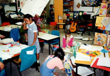
The children in the art class were pupils at Bulla Primary School in the early 1990s. Bulla Primary School was a semi -rural school in the township of Bulla, about 10kms from the Tullamarine Airport. There is no evidence of computers or other IT aids in the classroom as these items did not come into widespread use until 2 decades later.A non-digital coloured photograph of six children in an art class at school. The four visible sets of tables and chairs are strewn with art materials and there are shelves in the background where books, folders and other items are kept along with a guitar. art activities, bulla primary school -
 Bacchus Marsh & District Historical Society
Map, Coimadai Parish Map, County of Bourke. Circa 1890s-1900s
The cadastral Parish of Coimadai, a subdivision of the County of Bourke, lies directly north of the township of Bacchus Marsh. The date of this map is uncertain. T.F. McGauran the person who made a photo-lithographic copy of the map was in charge of photo-lithography at the Victorian Department of Lands and Survey in the late 19th century until about 1910.A single page paper map showing the map for the Parish of Coimadai in the County of Bourke. A cadastral map showing parish boundaries and land ownership. A rectangle shaped area is missing from the centre of the map due to a tear or deliberate excision. The map is pasted into a bound volume containing 76 maps or plans in total. High resolution digital image stored on BMDHS computer network. Photo-lithographed at the Department of Lands and Survey, Melbourne by T.F. McGauran 26.8.[??] NOTE. Photo litho from L.P showing temporary surveys and occupation of land prepared for departmental use onlybacchus marsh region parish plans, coimadai parish maps, coimadai parish plan -
 Bendigo Historical Society Inc.
Newspaper - JENNY FOLEY COLLECTION: SURVIVOR
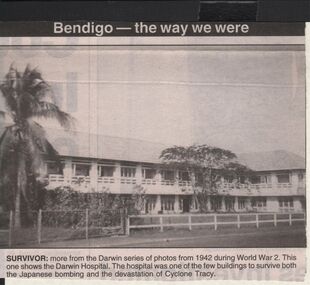
Darwin was bombed a total of 64 times during the war. The biggest and most deadly air-raids occurred on19/1/1943. Two hundred and forty two Japanese aircraft bombed the township, harbour and 2 airstrips. There were 235 deaths, 9 ships sunk in the harbour and 9 aircraft destroyed.Bendigo Advertiser ''The way we were'' from Monday, December 30, 2002. Survivor: more from the Darwin series of photos from 1942 during World War 2. This one shows the Darwin hospital. The hospital was one of the few buildings to survive both the Japanese bombing and the devastation of cyclone Tracy. The clip is in a folder.newspaper, bendigo advertiser, the way we were -
 Bendigo Historical Society Inc.
Newspaper - JENNY FOLEY COLLECTION: WAR TORN
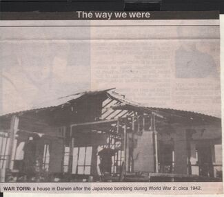
Darwin was bombed a total of 64 times during the war. The biggest and most deadly air-raids occurred on19/1/1943. Two hundred and forty two Japanese aircraft bombed the township, harbour and 2 airstrips. There were 235 deaths, 9 ships sunk in the harbour and 9 aircraft destroyed.Bendigo Advertiser ''The way we were'' from 2003. War torn: a house in Darwin after the Japanese bombing during World War 2, circa 1942. The clip is in a folder.newspaper, bendigo advertiser, the way we were -
 Bendigo Historical Society Inc.
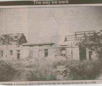
Newspaper - JENNY FOLEY COLLECTION: DAMAGED
Darwin was bombed a total of 64 times during the war. The biggest and most deadly air-raids occurred on19/1/1943. Two hundred and forty two Japanese aircraft bombed the township, harbour and 2 airstrips. There were 235 deaths, 9 ships sunk in the harbour and 9 aircraft destroyed.Bendigo Advertiser ''The way we were'' from 2002. Damaged: a Commercial Bank in Darwin shortly after the Japanese bombed the city in 1942. The clip is in a folder.newspaper, bendigo advertiser, the way we were -
 Ballarat Tramway Museum
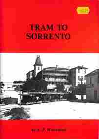
Book, A P Winzenried, "Tram to Sorrento", 1984
Book - titled "Tram to Sorrento", written by Arthur Winzenried, published by APW Productions Melbourne 1984. Covers the history of the steam tram operation from Sorrento township to the back beach. Including the operator G. S. Coppin, the locomotives, rolling stock, staff, stories and closure. Gives lists of shareholders as well.Yields information about a steam tram that operated between the two beaches in Sorrento - 1890 to 1920.Book - 56 pages including card cover printed on off white paper, centre stapled,trams, tramways, sorrento, steam trams, horse trams, tourism -
 Melbourne Tram Museum
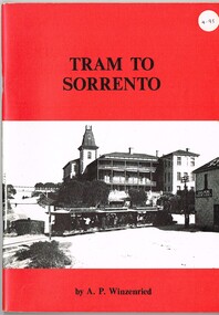
Book, Arthur Winzenried, "Tram to Sorrento", 1984
Book - titled "Tram to Sorrento", written by Arthur Winzenried, published by APW Productions Melbourne 1984. Covers the history of the steam tram operation from Sorrento township to the back beach. Including the operator G. S. Coppin, the locomotives, rolling stock, staff, stories and closure. Gives lists of shareholders as well.Yields information about a steam tram that operated between the two beaches in Sorrento - 1890 to 1920.Book - 56 pages including card cover printed on off white paper, centre stapled, Has a $4.95 sticker in the top right hand corner.trams, tramways, sorrento, steam trams, horse trams, tourism -
 Kiewa Valley Historical Society
VHS Tape - Kiewa Hydro Electricity Scheme x2, Kiewa, Circa 1990
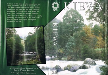
This VHS was produced by the State Electricity Commission of Victoria, to show the pristine state of the Kiewa River and Valley post the completion of the Kiewa Hydro Electricity Scheme (Circa 1950s), The late 1970s on wards was the beginning of deeper social scrutineering by pro environmental groups such as the Australian Wilderness Society (1976) and the Greens (political Party), before, during and after the construction phases of any man made structures in forest/bush areas which may or could damage or adversely affect the natural flora and fauna of sites. This promotional VHS, which was produced in the 1990s, was to project that unlike the Tasmanian State Electricity Commission (Franklin Dam issue), the Victorian State Electricity Commission acted in a way to protect the environment to the maximum level possible. With the passage of time since, and the issue of the global push to minimise carbon pollution, and as an alternative to coal fired power stations, the use of hydro electricity can now be seen as a highly efficient alternative to "coal powered" electricity. This VHS is a snap shot in time (1990) when the Kiewa Valley was still relatively under populated and holiday houses owned by city bound workers was still relatively insignificant. As more and more holiday makers retire to a small but friendly region(Kiewa Valley and Mount Beauty) the increase in visitor numbers will affect the local rural bush scene more and more. The changes that will occur (in time) can be measured against the scenes presented in this video. The additional resources provided by the State Electricity Commission of Victoria of "alpine bush" fire control and management, together with an ongoing educational scheme for school children in learning about what constitutes the Alpine country's unique environment, are a very important offshoot, benefitting to both the communities within the Kiewa Valley and regional Victoria.This VHS tape is stored within its own plastic cover which has a front side covered by a coloured photograph(both front and back cover) of the Kiewa River, just to the north east of the Mount Beauty township. The VHS tape is nestled within a formed inner structure which not only prevents the tape from moving to and fro but also unnecessary intrusion of foreign particles.Front cover "KIEWA" on the spine top circle with lines projecting out and below this "SEC". Middle of spine "KIEWA" and bottom of spine "VHS"secv, kiewa valley, dale-bromley, cy-duff, chris- harding, michael-glucz, forestation education, wilderness photography, nature film. -
 Bendigo Historical Society Inc.
Map - HEATHCOTE : COUNTY OF BENDIGO, May 1952
Map. Heathcote, County of Bendigo, County of Housie, Knowsley, Knowsley East, Langwornor, Tooborac, Warrowitue, Costerfield, Dargile, Township of Heathcote, Meadows Valley Creek, Wallan and Bendigo Railway, C.R.B. Main Road. By authority J.J. Gourley, Government Printer, Melbourne, Drawn and reproduced at the Department of Lands and Survey, Melbourne. May 1952, Price 2/-. (number 89 in map cupboard 1)J.J. Gourley, Government Printer, Melbourne.map, bendigo, heathcote -
Bendigo Historical Society Inc.
Map - MARONG : COUNTY OF BENDIGO, June 1953
Map. Marong, County of Bendigo, Nerring, Sandhurst, Lockwood, Shelbourne, Woodstock, Leichardt, Fletcher Creek, Bullock Creek, Township of Marong, Marong Railway Station, Bendigo Railway Line, Spring Creek, Crusoe Aqueduct. By authority W.M. Houston, Government Printer. Drawn and reproduced at the Department of Lands and Survey, Melbourne, Victoria. June 1953. Price 2/-. (number 73 in map cupboard 1)W.M. Houston, Government Printermap, bendigo, marong -
 Bendigo Historical Society Inc.
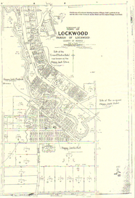
Map - LONG GULLY HISTORY GROUP COLLECTION: LOCKWOOD TOWNSHIP
Copy of a map of Township of Lockwood, County of Bendigo. Printed at the top of the map is: Parish map of Lockwood showing location of Happy Jack's paddock & hut and the sites of the Crown & Anchor Hotel and the original Happy Jack Hotel. Written on the map with arrows pointing to the site is: Happy Jack's Paddock, Site of the original Happy Jack Hotel and Happy Jack's Hut. An outline of Happy Jack's Paddock is drawn in.bendigo, history, long gully history group, the long gully history group - lockwood township, crown & anchor hotel, happy jack hotel, happy jack store, county of bendigo -
Eltham District Historical Society Inc
Document - Folder, Page, William Austin
William Austin Page was, in the 1868 Post Office Directory, a resident of Eltham township, a storekeeper (W & C Page, at Evelyn) and a petitioner for Eltham District Road Board and Eltham police station. He died 1884, aged 75, in South Yarra. Contents Notes no date or author: Research on William Austin Page.Newspaper clippings, A4 photocopies, etcwilliam austin page, w & c page store at evelyn, eltham police station, eltham district road board -
 Marysville & District Historical Society
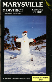
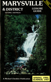
Booklet (Item) - Leisure guide, Michael Chesire & Associates Pty. Ltd, MARYSVILLE & DISTRICT LEISURE GUIDE-WINTER/SPRING 1987, 1987
A free leisure guide to Marysville and the surrounding district published for Winter and Spring, 1987. This was produced by Michael Cheshire as a free publication to promote tourism in Marysville and the surrounding district. It includes maps of the Big River Valley, Cumberland Valley, Lady Talbot Forest Drive, the Marysville area, and the township of Marysville. It was released in the winter of 1987. A free leisure guide to Marysville and the surrounding district published for Winter and Spring, 1987.marysville, victoria, australia, leisure guide, michael cheshire & associates pty ltd, marysville golf club, blackwood lodges, sir colin mackenzie fauna park, lake eildon, fraser national park, yarra valley wineries, marysville coach tours, kooringa, marylands guest house, lady talbot forest drive, wishing well, taggerty river recreation area, athols abbey, phantom falls, keppel falls, the beeches walking track, marylyn guest house, kufstein inn motel, the cumberland, marysville tourist & progress association, marysville newsagency & general store, crossways restaurant & motel, beauty spot walk, tree fern gully walk, michaeldene track, keppel track, woods lookout track, marysville hotel motel, lake mountain ski hire, marysville recreation and fun park, mytanta horseback safaris, upper big river valley, the big culvert, marysville mountain view horse hire, maryton park, amber view holiday lodges, cathedral restaurant, the top shop, tower motel, menzes garage, marysville ski hire, lake mountain ski school, faraway forest, scenic motel, buxton trout farm, marysville hardware, timbertop steakhouse, marysville trout farm, healesville sanctuary, buxton hotel motel, nanda binya lodge, buxton antique and furniture mart, the black spur inn hotel, alexandra, lake mountain, j l gould sawmills pty. ltd., geoffrey pope & associates, marysville crafts & gifts, olde yarra track shoppe, cumberland scenic reserve, tudor lodge road house, fruit salad farm, highwayman's retreat, beauty spot display gardens & nursery, ski lake mountain cross country ski hire & kitchen, buxton store, valley view marysville, acheron way, mt donna buang road, snow gum woodlands, alpine ash forests, mountain ash forests, stringybark forests, messmate forests, manna gum forests -
 Eltham District Historical Society Inc
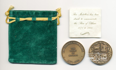
Medallion, Shire of Eltham et al, Medallion and pouch, In Commemoration, The Shire of Elham, 1871-1994, 1994
This medallion was struck to commemorate the Shire of Eltham, 1871 to 1994; issued upon cessation of the Shire of Eltham as a local government body following the widespread dismissal of councils throughout Melbourne by the Kennett Liberal Government. Parts of the Shire were redistributed to Banyule Shire and a new Nillumbik Shire was formed which took in Eltham township.Bronze coloured medallion approx 4 cm diameter in a clear plastic sleeve and green felt pouch with gold coloured tie Two copiesshire of eltham, medallion -
Tatura Irrigation & Wartime Camps Museum
Photograph, D. Walker, Commercial Hotel Tatura, 1986
Photograph of Commercial Hotel, corner Hogan and Ross Streets, Tatura. One of the earliest in township. Built by Ted Reid, c 1870. T. Hogan purchased hotel and he and his family carried on the business till about 1908. The Telestar room, added later. The Maher family ran the hotel for many years.Black and white photograph of Commercial Hotel, Tatura. Exterior. One of two photographson back: Commercial Hotel corner Hogan and Ross Streets, Tatura 1986.commercial hotel tatura -
 Ballarat Tramway Museum
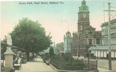
Postcard - copy, "Town Hall Sturt Street Ballarat Vic", c2000
Postcard of Sturt St looking East from about Doveton St with Shoppee Square, Snows store and the Town Hall in the view. Card reproduced for Sovereign Hill Gold Mining Township by Rose Stereograph Co. of Glen Waverley c2000. Divided back type with caption, production and the Rose Co. symbol on the rear.Yields information about the appearance of Sturt St following the introduction of electric trams in 1905 and has a strong association with the work of Sovereign Hill and Rose Stereograph Co.Postcard reproduction - full colour - Rose Stereograph Co.trams, tramways, sturt st, ballarat, esco, rose postcards, town hall, shoppee's square, snows -
 Sunbury Family History and Heritage Society Inc.
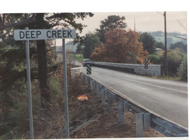
Photograph, Bulla, C 1980s
The photograph shows the approach to the Bulla Bridge at Deep Creek in the Township of Bulla. Immediately on crossing the bridge there is a sharp bend in the road and a step ascent up Bulla Hill through the cutting until level ground is reached. The photograph is looking to the NW. Deep Creek meets the Maribyrong River further downstream and closer to Keilor.The bridge and road replaced the ford crossing in 1869 that was downstream from the bridge.A coloured photograph of the approach to a bridge over the Deep Creek at Bulla along Sunbury Road. bulla bridge, deep creek, sunbury road -
 Sunbury Family History and Heritage Society Inc.
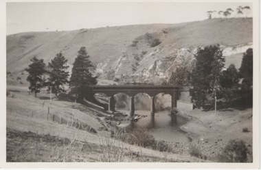
Photograph, 27 June 1934
This is a photograph of the bridge in the Bulla township which spans the Deep Creek, a tributary of the Maribyrnong River. It has been constructed from bluestone which is found across the volcanic western plains in Victoria. Kaolin was quarried from the cliff face in the background and was used in the making of bricks and pottery products manufactured at Northcote and Brunswick potteries.This is one of the many notable bluestone bridges which were built in the district in the nineteenth century.A black and white photograph of a valley with a five arched bridge spanning a river. There are high cliffs in the background.bulla township, deep creek, bridges -
 Ringwood and District Historical Society
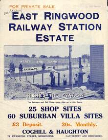
Flyer, Land Sale Brochure, East Ringwood Station Estate - c.1925
Multi-fold double sided sheet with yellow and blue print and blue monotone photographs advertising private sale of retail and residential sites. Brochure includes price list, and details of subdivision features and local facilities, with photographs. Additional clipped map of Estate on cardboard backing with handwritten sales notations and title ref LP11245.Subdivision includes Railway Avenue, Dublin Road, Lawrence Grove, Stanley Avenue. Agents - Coghill & Haughton, 79 Swanston Street, Melbourne, Phone Central 2793. Photographs include construction of East Ringwood Railway Station, "The Dive" where aquatic sports are held, Old East Ringwood Township, Davey's Hill. -
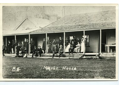
 Orbost & District Historical Society
black and white photograph, C1900
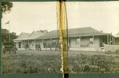
The first settler to occupy the Marlo township area was James Stirling around the year 1875. He built a bark hut on the bluff that had two rooms, bark walls, earthen floors and a shingle roof. By 1884, this structure had expanded to a 9 roomed accommodation house and in 1886 became the Marlo Hotel when a liquor license was granted. The Governor-in-Council declared Marlo to be a township on 18 February 1889. During May 1889, the government surveyor, E.L. Bruce set out 19 sections of the new township, with the first sales of subdivided land occurring the following May. At this time, Stirling's Marlo Hotel was the unofficial hub for the community. It was a general store, accommodation house and the unofficial post office, with settlers taking turns in bringing the mail from Orbost or Cunningham. This continued until Aug 1942, and in 1969 was located in a house adjacent to the Marlo Hotel, before being transferred to the Marlo General Store in this year. The official Post Office List states the Marlo Post Office opened around 1902. in 1925, the "Marlo House" (a nine room accommodation guest house) was granted a liquor licence. The "Marlo House" became "The Marlo Hotel". The Marlo Hotel was popular with many Orbost and district settlers, who travelled to Marlo by horseback or buggy. The Marlo Hotel, perched on the hill overlooking the estuaries and the entrance is a significat building in Marlo. Established in 1886, it has been operating for over 120 yearsA black / white photograph of the Marlo Hotel. Patrons are standing on the verandah and lawns. A horse-drawn carriage is on the left. The photograph is on a green buff card with a rough edge on R H side.on back - " Old Marlo Hotel"marlo-house marlo-hotel stirling-james -
 Orbost & District Historical Society
black and white photograph, C 1900
The first settler to occupy the Marlo township area was James Stirling around the year 1875. He built a bark hut on the bluff that had two rooms, bark walls, earthen floors and a shingle roof. By 1884, this structure had expanded to a 9 roomed accommodation house and in 1886 became the Marlo Hotel when a liquor license was granted. The Governor-in-Council declared Marlo to be a township on 18 February 1889] During May 1889, the government surveyor, E.L. Bruce set out 19 sections of the new township, with the first sales of subdivided land occurring the following May. At this time, Stirling's Marlo Hotel was the unofficial hub for the community. It was a general store, accommodation house and the unofficial post office, with settlers taking turns in bringing the mail from Orbost or Cunningham. This continued until Aug 1942, and in 1969 was located in a house adjacent to the Marlo Hotel, before being transferred to the Marlo General Store in this year. The official Post Office List states the Marlo Post Office opened around 1902. in 1925, the "Marlo House" (a nine room accommodation guest house) was granted a liquor licence. The "Marlo House" became "The Marlo Hotel". The Marlo Hotel was popular with many Orbost and district settlers, who travelled to Marlo by horseback Perched on the hill overlooking the estuaries and the entrance, the Marlo Hotel is a significant building in Marlo. It was established in 1886 and has been operating for over 120 years,A black / white photograph of Marlo House with staff and patrons standing and sitting on the verandah.on front - "H.S. Marlo House"marlo-house marlo-hotel -
 Warrnambool and District Historical Society Inc.
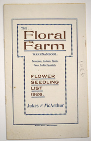
Booklet - Florist Booklet, Modern Print Warrnambool, The Floral Farm Warrnambool Flower Seedling List 1926, 1926
A business booklet of plants for sale and seasonal suggestions for planting.This booklet has sixteen pages with gold and blue printing on the white cover. The pages contain printed material. The pages have been stapled but the staples have been removed.non-fictionA business booklet of plants for sale and seasonal suggestions for planting.warrnambool plant nurseries, charles jukes -
 Marysville & District Historical Society
Booklet (Item) - Leisure guide, Michael Chesire & Associates Pty. Ltd, MARYSVILLE & DISTRICT LEISURE GUIDE-SPRING, 1986/SUMMBER, 1987, 1986
A free leisure guide to Marysville and the surrounding district published for Spring 1986, and Summer, 1987. This was produced by Michael Cheshire as a free publication to promote tourism in Marysville and the surrounding district. It includes maps of the Big River Valley, Cumberland Valley, Lady Talbot Forest Drive, the Marysville area, and the township of Marysville. It was released in the spring of 1986. A free leisure guide to Marysville and the surrounding district published for Spring 1986, and Summer 1987.Kilmore Historical Society *10/183 *MDL.1.marysville, victoria, australia, leisure guide, michael cheshire & associates pty ltd, marysville golf club, blackwood lodges, sir colin mackenzie fauna park, lake eildon, fraser national park, yarra valley wineries, marysville coach tours, kooringa, marylands guest house, lady talbot forest drive, wishing well, taggerty river recreation area, athols abbey, phantom falls, keppel falls, the beeches walking track, marylyn guest house, kufstein inn motel, the cumberland, marysville tourist & progress association, marysville newsagency & general store, crossways restaurant & motel, beauty spot walk, tree fern gully walk, michaeldene track, keppel track, woods lookout track, marysville hotel motel, lake mountain ski hire, marysville recreation and fun park, mytanta horseback safaris, upper big river valley, the big culvert, marysville mountain view horse hire, maryton park, amber view holiday lodges, cathedral restaurant, the top shop, tower motel, menzes garage, beauty spot nursery, marysville ski hire, lake mountain ski school, faraway forest, scenic motel, buxton trout farm, marysville hardware, timbertop steakhouse, marysville trout farm, healesville sanctuary, buxton hotel motel, nanda binya lodge, buxton antique and furniture mart, the black spur inn hotel, alexandra, lake mountain, j l gould sawmills pty. ltd., geoffrey pope & associates, marysville crafts & gifts, olde yarra track shoppe, cumberland scenic reserve, tudor lodge road house, fruit salad farm, highwayman's retreat -
Glen Eira Historical Society
Letter - Elsternwick
A letter from Jeff Atkinson dated 05/06/1997, relating his research on the name Elsternwick and two photocopied photos of the name, taken in England. Two copied pages from BULMERS 1892 on Elsternwick Township, another page c.1871 and dated maps 1786, with Elsternwick/ Elstronwick in the parish of Danthorpe U.K.atkinson jeff, parkside street, elsternwick, ebden charles hotson, elster, elstronwick, caulfield -
 Linton and District Historical Society Inc
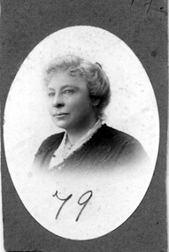
Photograph, Mrs E R Sayce (née Phemie Nicol), 1915
Phemie Nicol was a daughter of Linton baker James Nicol. She married Alfred Sayce in 1886. Her recollections of life and people in Linton in the early days of the township (1860s to 1880s) are recorded in the 1939 history booklet: 'Looking back over 100 years. 1839-1939'. Photograph is part of Old Lintonian collection ; No. 79.Sepia oval portrait of a lady wearing blouse and jacket."E R Sayce July 1915 St Kilda"mrs e r sayce, old lintonian collection, phemie nicol, phemie sayce -
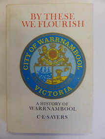 Warrnambool and District Historical Society Inc.
Book, By These we Flourish, 1969
This book is a first edition of the Council-sponsored official history of Warrnambool. It was written by the professional historian, C.E. Sayers. He had access at the time to the notes, photographs, radio talks and other writings of the former Warrnambool Town Clerk and noted historian, Henri Worland. This book is of great importance as the chief comprehensive historical work published about Warrnambool since Vidler’s ‘Warrnambool Past and Present’ published in 1907. Even though a second edition of this book was published in 1987 this edition is still very important as it contains several photographs and some textual references not included in the later book. This edition is therefore still useful today and copies of it are not easy to find now. This is a hard cover book of 190 pages. The cover has a photograph in sepia tones of men road-making with the same photograph back and front. This has a cream background with red and black lettering and a coloured image of the Warrnambool City crest on the front. An early map of the Warrnambool township has been reproduced on the inside of the cover, back and front. The book has a foreword, an introduction, 21 chapters of text, notes and appendices. by these we flourish, history of warrnambool, c.e. sayers -
Kiewa Valley Historical Society
Papers - Mt Beauty Airport Development
The SECV began investigating four possible sites for an airstrip in Mt Beauty in 1965. The land was owned by the SEC and leased by Mr J. Sharp. It became available on the condition that the land would only be available to the Municipal shire. This land was officially opened as an Airport as an official tourist activity in 1977. It continues to be available to tourists, fire fighters, the air ambulance and the local gliding club.The opening of Mt Beauty Airport has enhanced Mt Beauty township by enabling fire fighters to access the surrounding bush during bush fires, by enabling Ambulance helicopters to rush emergency patients to city hospital, by giving tourists the opportunity to fly in and to give the local Gliding Club the opportunity to store and fly their gliders. 1. Set of papers titled 'History Mt Beauty Airport Development' held together by large steel clip by Alex McCullough. 2. Set of papers titled 'Department of Transport' and 'Alpine Shire' both held together by one staple. 3.Mt Beauty Township Survey Plan of Airstrip 1975 4. Large folder titled Mr J. R. Sharp 1975 - Mt Beauty Airfieldmt beauty airport history, alex mccullough, transport, tourism -
 Kiewa Valley Historical Society
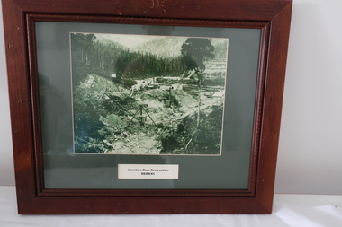
Set of 6 framed photographs - Kiewa Hydro Electric Scheme
Official photos - Kiewa Hydro Electric Scheme constructed by State Electricity Commission of VictoriaOfficial photos of KHES in the Kiewa Valley1. Junction Dam Excavation - 5th April 1941 2. Bogong Residential Area Development - 24th April 1940 3. Beginning of Mt Beauty Township - 20th February 1947 4.Pretty Valley Bridge - 9th September 1940 5. Junction Dam - General View from Downstream - 15th September 1943 6. Construction of Dam Wall for Rocky Valley Dam - 1958khes, secv -
 Kiewa Valley Historical Society
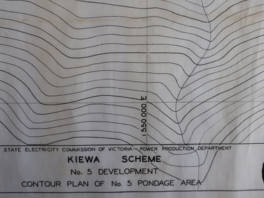
Plans - Kiewa Works Area and Environs
State Electricity Commission of Victoria constructed the Kiewa Hydro Electric Scheme from the late 1940s to 1961. These plans were used during the construction.Plans and Maps were used during the construction of the Kiewa Hydro Electric SchemeTransparent with blue tinge plans/maps created by the SECV during the construction of the Kiewa Hydro Electric Scheme. 1. Kiewa Scheme No 5 Development Contour Plan of No 5 Pondage Area 2. Mt Beauty Township 3. Kiewa Scheme No 1 Development - McKay Creek Area, Construction Layout 4. Kiewa Works and Environs 5. North Eastern Victoria and Adjoining Snowy Mountains Regionsecv, kiewa hydro electric scheme plans