Showing 1831 items matching "storage "
-
 Bendigo Historical Society Inc.
Map - Black and white map pertaining to Lake Eppalock
John Perry Collection. Laminated copy of map relating to Lake Eppalock. Lists dwellings, ford crossings and bridges. The dam was built by the State Rivers and Water Supply Commission of Victoria. The dam wall height is 45 metres (148 ft) and the main embankment is 1,041 metres (3,415 ft) long. At 100% capacity the dam wall was designed to hold back 304,651 megalitres (6.7014×10¹⁰ imp gal; 8.0480×10¹⁰ US gal) of water. The surface area of Lake Eppalock is 3,011 hectares (7,440 acres) and the catchment area is 2,124 square kilometres (820 sq mi). The controlled spillway is capable of discharging 8,040 cubic metres per second (284,000 cu ft/s). Lake Eppalock supplies both stock and domestic water to the Campaspe irrigation district. It also serves as a water supply to Bendigo and Heathcote and, in more recent times, Ballarat. The lake is a major attraction for those engaging in watersports, with a number of tourist parks and accommodation facilities available. Permissible activities on the lake include high-speed boating, water skiing, sailing, canoeing, fishing and swimming. The lake's water levels were low for approximately eight years between 2002 and 2010 during a prolonged drought, which restricted the amount of recreational activity until rainfall in the latter half of 2010 returned the lake to 100 percent capacity. Built between 1961 and 1964, Lake Eppalock remains the only water storage on the Campaspe River system.map, water, dam, reservoir, eppalock -
 Bendigo Historical Society Inc.
Map - General view of area of proposed construction of Lake Eppalock. Map 'A'
John Perry Collection. Laminated map of proposed construction of Lake Eppalock. Map 'A'. Black and white map in laminate. Circa 1951. The dam was built by the State Rivers and Water Supply Commission of Victoria. The dam wall height is 45 metres (148 ft) and the main embankment is 1,041 metres (3,415 ft) long. At 100% capacity the dam wall was designed to hold back 304,651 megalitres (6.7014×10¹⁰ imp gal; 8.0480×10¹⁰ US gal) of water. The surface area of Lake Eppalock is 3,011 hectares (7,440 acres) and the catchment area is 2,124 square kilometres (820 sq mi). The controlled spillway is capable of discharging 8,040 cubic metres per second (284,000 cu ft/s). Lake Eppalock supplies both stock and domestic water to the Campaspe irrigation district. It also serves as a water supply to Bendigo and Heathcote and, in more recent times, Ballarat. The lake is a major attraction for those engaging in watersports, with a number of tourist parks and accommodation facilities available. Permissible activities on the lake include high-speed boating, water skiing, sailing, canoeing, fishing and swimming. The lake's water levels were low for approximately eight years between 2002 and 2010 during a prolonged drought, which restricted the amount of recreational activity until rainfall in the latter half of 2010 returned the lake to 100 percent capacity. Built between 1961 and 1964, Lake Eppalock remains the only water storage on the Campaspe River system.map, dam, water, weir, eppalock -
 Eltham District Historical Society Inc
Photograph, Peter Pidgeon, Grave of John and Mary Murray, Eltham Cemetery, Victoria, 5 April 2021
Irish-born John Murray and his wife Mary (daughter of Thomas Sweeney) married in 1849 and settled in Eltham North. John and Mary were amongst the earliest inhabitants of Eltham. John was a farmer and their block of about 80 acres, called ‘Laurel Hill’, was on the eastern side of the Diamond Creek, extending east to beyond Zig Zag Road. It was later extended southward by the purchase of a further 60 acres. He is recorded as a supporter on the petition for a school in Eltham and he served on the National School Board of the Eltham school. John died in 1867 and is buried in Eltham Cemetery with Mary and with two of their grandchildren. Their eldest son Johnnie inherited the property. Then in about 1902 his younger brother James purchased about 50 acres on the western side of the Diamond Creek immediately opposite Laurel Hill, extending west to slightly past Wattletree Road. Eltham North Reserve now lies just beyond the southern boundary. James built a family home on top of the hill on the northern boundary, together with a dairy and milking shed and a food cellar. It is thought that the barn with stables was already there. When Johnnie died in 1912, the two properties (though severed by both the creek and the railway line) effectively merged. The land was worked as an orchard with apples, pears, quinces, and possibly apricots and peaches. Later it became a dairy farm. By 1986, almost all the land had been sold off for residential subdivision and the house had been condemned as unfit for habitation. John's grandson Jim retained a small portion of the land and built a new house. He kept the old one as a storage shed, but it was demolished after he died in 1993. The very old barn is still standing. Located in the Roman Catholic section In Memory of John Murray Who died Dec. 1867 aged 50 years Also his wife Mary Murray Who died 7th Sep. 1909 aged 76 years And of their grandchildren Thomas and Mary Ellen DrainBorn Digitaleltham cemetery, gravestones, john murray, mary ellen drain, mary murray, thomas drain -
 Eltham District Historical Society Inc
Photograph, Fay Bridge, Ruins beside the Diamond Creek at Wattle Glen, 13 October 2016
The newly constructed Diamond Creek Trail from Diamond Creek to Wattle Glen completed in February 2021 winds around these ruins just pass the high transmission power lines near Herberts Lane and Collard Drive From Jean Verso, Nillumbik Historical Society, 15 April 2021 William Wandless Herbert bought the surrounding 100 acres in 1852. He was a native of Northumberland and the Scottish Borders who arrived in Melbourne in 1847. The house on the top of the mound would have been built not long after he bought the land; the farm was named "Greenhills". He married Elizabeth Wilson, daughter of John Wilson who had been in Diamond Creek since about 1846. Their first child was born in 1854 so there would be some form of dwelling from about that time. They had eight children who all survived to a good age. His will describes the house as part stone and part wood and of four rooms. Nillumbik Historical Society (NHS) believe it was one of the earliest if not the earliest house, in this part of the district. The remains of the stone house foundations are on top of the mound (photos on the VHD page) and the barn walls are on the north and to the east side of the mound. NHS is not sure how much or which part of the surrounding area was covered by the barns but they were large enough to hold dances after the race meetings that were held in the late 1880's on the adjacent creek flats. It would make sense with the lay of the land that they covered some of the ground to the north and east and used for farm storage, packing sheds for their apple and pear orchards and also for supporting the Nillumbik Gold Mine the family worked to the north up the gully. The path that comes down the gully and runs into the trail goes past the mine site which was on the west side of the gully a couple of hundred metres up from the flats. Heritage Victoria link for the site - https://vhd.heritagecouncil.vic.gov.au/places/12203fay bridge collection, 2016-10-13, diamond creek, diamond creek trail, ruins, wattle glen, william wandless herbert, greenhills, elizabeth wilson -
 Eltham District Historical Society Inc
Negative - Photograph, Popular Picnicing at Hurstbridge, c.1925
Picnickers enjoying a Sunday outing near the Wattle Valley Estate at Hurstbridge. Copied from brochure "Wattle Valley Estate". It is believed the picture is taken at the northwest corner of the intersection of Wattletree Road and Hurstbridge-Arthurs Creek Road looking southeast towards the township (most likely where the house is located on the property of what is today No. 2 Wattletree Road)- https://goo.gl/maps/VDorwCe1rJJUapjE6 According to a comment by Jean Verso (via @nillumbikcouncil FB page 3 Jan 2020) - "This view is from Wattle Tree Road with Haleys Gully Road to the right and across the creek to William Gray's nursery at Allwood. The building to the far left looks like Dorset House. The building on the left in the middle distance is still there today and has been used for storage and as a stable/tack room for a number of years." The Wattle Valley Estate was first advertised in August 1925 as weekend building allotments by the Greater Melbourne Land and Development Company. Advertised from £28.10.0 or £60 per block. In August 1926, 30 picked allotments of 60x150 feet were put up for auction Saturday August 14, 1926 with frontages to Valley View Road and Fawkner Crescent advertised in the “Heart of the Glorious Wattle Country” and “Within 15 Minutes of the Newly Electrified Railway Station”. The Advertiser on August 13, 1926 in an article promoting the auction stated “the estate is regarded as one of the best in the district, and will be sold practically without reserve.” It is noted that an advertisement running in The Argus February 22, 1951 offered the remaining 16 blocks for sale at £12.10.0 or £200 the lot. By March 7, the remaining blocks were advertised at £17.10.0 The Wattle Valley Estate took over 20 years to sell and then people could not build on them Cross Ref EDHS_02665 Rose Series Postcard P. 4341, "View at Hurstbridge, Vic." Also, other images from sales brochure SEPP_1055 / 1056This photo forms part of a collection of photographs gathered by the Shire of Eltham for their centenary project book,"Pioneers and Painters: 100 years of the Shire of Eltham" by Alan Marshall (1971). The collection of over 500 images is held in partnership between Eltham District Historical Society and Yarra Plenty Regional Library (Eltham Library) and is now formally known as the 'The Shire of Eltham Pioneers Photograph Collection.' It is significant in being the first community sourced collection representing the places and people of the Shire's first one hundred years.Digital image 4 x 5 inch B&W Neg1925, dorset house, fawkner crescent, haleys gully road, hurstbridge, hurstbridge-arthurs creek road, picnic, postcards, shire of eltham pioneers photograph collection, valley view road, wattle valley estate, wattletree road, exhibition yprl 2019-12 -
 Eltham District Historical Society Inc
Photograph - Postcard, Rose Stereograph Company, View at Hurstbridge, Vic, c.1925
Rose Series Postcard P. 4341 “View at Hurstbridge, Vic.” Picnickers enjoying a Sunday outing near the Wattle Valley Estate at Hurstbridge. Copied from brochure "Wattle Valley Estate". It is believed the picture is taken at the northwest corner of the intersection of Wattletree Road and Hurstbridge-Arthurs Creek Road looking southeast towards the township (most likely where the house is located on the property of what is today No. 2 Wattletree Road)- https://goo.gl/maps/VDorwCe1rJJUapjE6 According to a comment by Jean Verso (via @nillumbikcouncil FB page 3 Jan 2020) - "This view is from Wattle Tree Road with Haleys Gully Road to the right and across the creek to William Gray's nursery at Allwood. The building to the far left looks like Dorset House. The building on the left in the middle distance is still there today and has been used for storage and as a stable/tack room for a number of years." The Wattle Valley Estate was first advertised in August 1925 as weekend building allotments by the Greater Melbourne Land and Development Company. Advertised from £28.10.0 or £60 per block. In August 1926, 30 picked allotments of 60x150 feet were put up for auction Saturday August 14, 1926 with frontages to Valley View Road and Fawkner Crescent advertised in the “Heart of the Glorious Wattle Country” and “Within 15 Minutes of the Newly Electrified Railway Station”. The Advertiser on August 13, 1926 in an article promoting the auction stated “the estate is regarded as one of the best in the district, and will be sold practically without reserve.” It is noted that an advertisement running in The Argus February 22, 1951 offered the remaining 16 blocks for sale at £12.10.0 or £200 the lot. By March 7, the remaining blocks were advertised at £17.10.0 The Wattle Valley Estate took over 20 years to sell and then people could not build on them Cross Ref SEPP_1057, “Popular Picnicing at Hurstbridge” rcopied from Wattle Valley estate sales brochure.Digital file only Postcards scanned from the collection of Michael Aitken on loan to EDHS, 13 Feb 20181925, dorset house, exhibition yprl 2019-12, fawkner crescent, haleys gully road, hurstbridge, hurstbridge-arthurs creek road, michael aitken collection, picnic, postcards, rose stereograph company, shire of eltham pioneers photograph collection, valley view road, wattle valley estate, wattletree road -
 Flagstaff Hill Maritime Museum and Village
Functional object - Cow Bell, Circa 1878
The artefact is a brass cow bell recovered from the 1878 shipwreck of the LOCH ARD near Port Campbell. It was raised by Flagstaff Hill divers in 1973 and is in storage at the Maritime Village. A cow bell is a bell worn around the neck of free-roaming livestock so herders can keep track of an animal via the sound of the bell when the animal is grazing out of view in hilly landscapes. Although they are typically referred to as "cow bells" due to their extensive use with cattle, the bells are used on a wide variety of animals. The earliest examples of truly recognizable cow bells date back to the Iron Age. The use of iron bells in sub-Saharan African music and the Niger–Congo area is linked to the early iron-making technology spread during the Bantu migrations. The earliest archaeological evidence of bells dates back to more than 5000 years ago, from the 3rd millennium BC in Neolithic China. During this era, there is evidence of early forms of pottery cow bells, which were likely used to keep track of goats, sheep, and cattle. These pottery bells were later replaced by metal bells using brass and other materials. The LOCH ARD was constructed on the Clyde in 1873 for the prestigious Loch Line of colonial clipper ships, designed for the Australian run. She sailed from England on 1 March 1878 carrying 37 crew, 17 passengers and a diverse general cargo ranging from luxury items to bulk railway iron. On 1 June 1878, emerging from fog and hearing too late the sound of breakers against the tall limestone cliffs, the vessel struck the southern foot of Mutton Bird Island and sank in 23 metres of water. Of the fifty-four people on board only two survived, one young male crewman, Tom Pearce, and one young female passenger, Eva Carmichael. (See References or Notes below for further details.)The cow bell is believed to be part of the cargo of the Loch Ard and this shipwreck of the Loch Ard is of historical significance for Victoria. Registered on the Victorian Heritage Register ( S 417), with Flagstaff Hill having a varied collection of artefacts from the Loch Ard. Its collection is significant for being one of the largest accumulation of artefacts from this notable Victorian shipwreck. The collections object is to also give us a snapshot into history so we can interpret the story of this tragic event. The collection is also archaeologically significant as it represents aspects of Victoria's shipping history that allows us to interpret Victoria's social and historical themes of the time. The collections historically significance is that it is associated unfortunately with the worst and best-known shipwreck in Victoria's history. Brass cow bell, covered in encrustations. flagstaff hill, warrnambool, shipwreck coast, flagstaff hill maritime museum, flagstaff hill maritime village, maritime museum, great ocean road, shipwreck artefact, loch ard, mutton bird island, glenample, eva carmichael, tom pearce, flagstaff hill divers, cow bell, horse bell, bell smith, vintage bell, farmer, shepherd, drover, stock bell, brass bell -
 Puffing Billy Railway
Explosives Wagon, unkown
This 2 foot 6 inch (762mm) gauge wagon was used for carrying explosives and was used with the Greenbat Battery loco. It was donated to the Walhalla Goldfields Railway on long term loan in 2013 along with a large quantity of narrow gauge trollies and light rail from Orica’s now closed munitions factory in Melbourne’s western suburbs. Orica - Deer Park Munitions factory Orica Deer Park in Melbourne’s west has been used since circa 1875 for various forms of manufacturing and storage of chemicals. Although the site is bounded by Ballarat Road, Station Street, Tilburn Road and the Western Ring Road, the current entry point for industrial operations is situated at Gate 6 of Tilburn Road. Operations include: • a specialty chemicals facility producing products for mining services operations • quarry services • other chemical manufacture activities. The Deer Park factory complex The factory complex is of historical significance for the major role it played in Australia's manufacturing and mining industries through the development of progressively more efficient and safer explosives. It also contributed to wartime production in ammunition, initiators and the development of synthetic ammonia production and construction of the Defence Explosives Annexe No 5 (later the Albion Explosives Factory) during World War Two. The factory complex is also of technical significance for the unusual and specialised design of many of the buildings and structures, both in the layout of the works and the individual design of buildings. Blast protection and safety measures such as mounds around the buildings, 'cleanways' and buffer zones between production areas were employed extensively. A characteristic of many production buildings was the elimination of cavities where explosive compounds could lodge. The combination of concrete barriers and light-weight construction was designed to direct explosion debris away from operators or other buildings. The narrow gauge tramway, which ran through the explosives section, is a rare survivor of nineteenth century materials-handling methods. Historic - Industrial Narrow Gauge Railway - Wagon for carrying Explosives at the Orica - Deer Park Munitions factory, Deer park, Victoria, Australia Wagon for carrying explosives made from Timber and steelwagon for carrying explosives, puffing billy, industrial narrow gauge railway, orica - deer park munitions factory, explosives wagon -
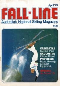 Falls Creek Historical Society
Magazine - Fall-Line - Australia's National Skiing Magazine April '79
“Fall-Line” was one of a series of magazines published by the Victorian Ski Association. It was produced from 1979 until 1985. It superseded their previous publication, “Ski” magazine and was followed by the “Australian Skiing” magazine. The Victorian Ski Association was formed in 1955.This magazine is significant because it documents developments in the ski industry in Australia.A magazine featuring a coloured image on the cover and containing articles and advertising related to developments in skiing in Australia. This issue included an update on improvements being made at Falls Creek. FALLS CREEK The chairlift access area near the medical centre, long famous as the Mudpie Parlour of Falls Creek, has been sealed and Falls Creek itself, the waters of which have filled many an unsuspecting gum- boot, has been bridged, also near the medical centre. A lock-up storage shed will be built along Bogong High Plains Road, just below the oversnow terminal, for the use and convenience of all village commercial operators and site holders. Direct access will be possible by snowmobile. Falls Creek rates have risen to $82.50 per bed (less 10% discount if paid on time). The rise is the first in two years, and is less than the corresponding rise in the C.P.I. over that period. The access trail from the water tanks at the base of the Home Trail to the nursery slope has been smoothed and widened to 12 metres, and a new six metre wide access trail has been cut from Falls Creek Road, just behind Diana lodge to the chairlift bottom station. The Village Bowl comfort station is being extended and renovated, and the finishing touches are being put on the comfort station in the upper car park. Construction of an akja station/toilet block in Sun Valley will commence in 1980. The Management Committee is investigating the purchase of a Mercedes 800 series snow-clearing machine to supplement the CRB equipment in use in village parking areas The village water supply has been re- designed to ensure adequate supply at all times.australian ski magazines, skiing australia, victorian ski association -
 Melbourne Tram Museum
Administrative record - Depot List, Bob Lilburn, "MMTB Engineering Department - Workshops and Running sheds Branch - Allocation of Tramcars", 1928 to 1985
Set of 20 photocopied lists, titled "MMTB Engineering Department - Workshops and Running sheds Branch - Allocation of Tramcars", listing allocation of tramcars to various depots, workshops, storage and disposal. Packet 1 1 - 16/6/1928 - 2 pages 2 - 9/6/1934 - 2 pages 3 - 30/6/1938 - 2 pages 4 - 12/3/1948 (?) - 2 pages 5 - 1/2/1949 - 4 pages 6 - 16/7/1949 - 2 pages 7 - 28/1/1950 - 2 pages 8 - 24/3/1951 - 2 pages Packet 2 9 - 24/1/1953 - 3 pages (one poor copy) 10 - 23/1/1954 - 2 pages 11 - 30/8/1958 - 2 pages 12 - 17/1/1959 - 2 pages 13 - 1/1961 - 2 pages 14 - 1/1962 - 2 pages 15 - 7/1963 - 2 pages 16 - 1/1964 - 2 pages 17 - 1/1965 - 2 pages 18 - 3/1965 - 2 pages Packet 3 10 - 1/1965 - 2 pages 11 - 1/1967 - 2 pages 12 - 1/1969 - 2 pages 13 - 1/1970 - 2 pages 14 - 1/1971 - 2 pages 15 - 1/1/1977 - 3 pages 16 - 1/7/1977 - 3 pages Packet 4 17 - 1/7/1978 - 2 pages 18 - 1/7/1979 - 4 pages 19 - 1/7/1980 - 4 pages 20 - 1/7/1985 - 7 pages - MTA header.trams, tramways, tramcars, mmtb, lists, depots, depot allocation -
 Bendigo Historical Society Inc.
Document - Black and white laminated photo of flow of water from Lake Eppalock. 1964
John Perry Collection. Laminated copy of photo of crowd watching flow of water from the opened valve at the wall of Lake Eppalock during its commissioning. March, 1964. Lake Eppalock was created by flooding to town of Wild Duck. The dam was built by the State Rivers and Water Supply Commission of Victoria. The dam wall height is 45 metres (148 ft) and the main embankment is 1,041 metres (3,415 ft) long. At 100% capacity the dam wall was designed to hold back 304,651 megalitres (6.7014×10¹⁰ imp gal; 8.0480×10¹⁰ US gal) of water. The surface area of Lake Eppalock is 3,011 hectares (7,440 acres) and the catchment area is 2,124 square kilometres (820 sq mi). The controlled spillway is capable of discharging 8,040 cubic metres per second (284,000 cu ft/s). Lake Eppalock supplies both stock and domestic water to the Campaspe irrigation district. It also serves as a water supply to Bendigo and Heathcote and, in more recent times, Ballarat. The lake is a major attraction for those engaging in watersports, with a number of tourist parks and accommodation facilities available. Permissible activities on the lake include high-speed boating, water skiing, sailing, canoeing, fishing and swimming. The lake's water levels were low for approximately eight years between 2002 and 2010 during a prolonged drought, which restricted the amount of recreational activity until rainfall in the latter half of 2010 returned the lake to 100 percent capacity. Built between 1961 and 1964, Lake Eppalock remains the only water storage on the Campaspe River system.water, dam, reservoir, eppalock, wild duck -
 Bendigo Historical Society Inc.
Map - Map of Lake Eppalock shoreline when empty
John Perry Collection. Laminated copy of map detailing Lake Eppalock shoreline when empty. Circa 1951. Has colored highlighter lines following roads leading to lake shoreline and various inundated old roads and tracks on lakebed. The dam was built by the State Rivers and Water Supply Commission of Victoria. The dam wall height is 45 metres (148 ft) and the main embankment is 1,041 metres (3,415 ft) long. At 100% capacity the dam wall was designed to hold back 304,651 megalitres (6.7014×10¹⁰ imp gal; 8.0480×10¹⁰ US gal) of water. The surface area of Lake Eppalock is 3,011 hectares (7,440 acres) and the catchment area is 2,124 square kilometres (820 sq mi). The controlled spillway is capable of discharging 8,040 cubic metres per second (284,000 cu ft/s). Lake Eppalock supplies both stock and domestic water to the Campaspe irrigation district. It also serves as a water supply to Bendigo and Heathcote and, in more recent times, Ballarat. The lake is a major attraction for those engaging in watersports, with a number of tourist parks and accommodation facilities available. Permissible activities on the lake include high-speed boating, water skiing, sailing, canoeing, fishing and swimming. The lake's water levels were low for approximately eight years between 2002 and 2010 during a prolonged drought, which restricted the amount of recreational activity until rainfall in the latter half of 2010 returned the lake to 100 percent capacity. Built between 1961 and 1964, Lake Eppalock remains the only water storage on the Campaspe River system.map, eppalock, reservoir, lake, water -
 Bendigo Historical Society Inc.
Document - Directions to Lake Eppalock with road descriptions and map
John Perry Collection. Laminated copy of 'Directions to Lake Eppalock'. Gives directions in relationship of Lake Eppalock to Bendigo, Kyneton and Heathcote. Undated. Gives basic descriptions of bridges on lakebed, ford crossings on lakebed and inundated dwellings on lakebed. The dam was built by the State Rivers and Water Supply Commission of Victoria. The dam wall height is 45 metres (148 ft) and the main embankment is 1,041 metres (3,415 ft) long. At 100% capacity the dam wall was designed to hold back 304,651 megalitres (6.7014×10¹⁰ imp gal; 8.0480×10¹⁰ US gal) of water. The surface area of Lake Eppalock is 3,011 hectares (7,440 acres) and the catchment area is 2,124 square kilometres (820 sq mi). The controlled spillway is capable of discharging 8,040 cubic metres per second (284,000 cu ft/s). Lake Eppalock supplies both stock and domestic water to the Campaspe irrigation district. It also serves as a water supply to Bendigo and Heathcote and, in more recent times, Ballarat. The lake is a major attraction for those engaging in watersports, with a number of tourist parks and accommodation facilities available. Permissible activities on the lake include high-speed boating, water skiing, sailing, canoeing, fishing and swimming. The lake's water levels were low for approximately eight years between 2002 and 2010 during a prolonged drought, which restricted the amount of recreational activity until rainfall in the latter half of 2010 returned the lake to 100 percent capacity. Built between 1961 and 1964, Lake Eppalock remains the only water storage on the Campaspe River system.water, dam, directions, eppalock -
 Flagstaff Hill Maritime Museum and Village
Functional object - Music stand, Early 19th Century before 1860
Thomas Sheraton (1751-1806) appears to have been the first to record the written term “Canterbury” music or magazine stand. In his Cabinet Dictionary of 1803 he refers to “a small music stand” with divisions for holding loose sheet or bound volumes of music. The music stand designed to hold sheet music came into fashion in the late 18th Century in England and was often crafted from mahogany, rosewood or walnut. They were seen as status symbols since music was practiced exclusively by the upper classes of society. In a period when printed music was more widely available and disseminated due to more affordable printing techniques, modern sheet music was very popular and therefore storage for such favoured tunes became a luxury and an opportunity for innovative design by cabinet makers. The Classical period of music, from about 1750 to 1820 and the Romantic Period from around 1815-1910 was the golden age of classical music. And it was at this time that The Canterbury often accompanied the piano in the parlour with styles ranging from Georgian simplicity to Victorian exuberance. Social activities of colonial Victoria would have included evening gatherings of family and friends around the piano to enjoy performances or sing along together with from old and up-to-date music sheets. The Canterbury would also be an elegant and practical place to also store newspapers, magazines, posters and drawings from overseas. The news from ‘home’ would be enjoyed by all. THE INSCRIPTION “Jack Morse” Morse. In 2010 Mr Jack Morse was recognised as one of the “people who have contributed to the long term development of Flagstaff Hill Maritime Village”. He was a member of the Flagstaff hill Planning board and a Current Life Member and had been awarded a Certificate of Service and the provision of an Annual Family Membership for life by Flagstaff Hill. The Morse’s family business, Morse’s Engineering, closed in 2010. It was considered “One of Warrnambool’s longest operating businesses with roots dating to 1883 with the design and manufacture of coaches and buggies, progressing to automotive repairs and later specialising in under-vehicle work” The Canterbury appears to have been handmade prior to 1860 as the dovetails are handmade and there are no saw marks on the drawer sides or back as well the sides. Also the back has small nicks indicating a hand plane or drawer knife was used rather than a saw blade to size the material. Additional indications are that the spindles are slightly different in size meaning they were handmade individually not mass produced. From these indicators the writer believes that the item was made before 1860 as machinery was only used after this date to produce furniture. As yet no individual maker can be attributed to this item, however it is a significant piece historically and is quite valuable if a known maker can be associated with the Canterbury. The item highlights a time in our social history when music played an everyday part in people’s lives as the only entertainment families could enjoy together in their own homes. A Canterbury music stand, having three compartments consisting of twenty turned spindles supporting the slat dividers. A drawer, with two turned wooden handles, is fitted below. The music stand has turnip style turned feet. The drawer front and carcass of the stand are veneered rosewood over a mahogany carcass. The underlined words "Jack Morse" are handwritten underneath the drawer bottom.Hand written inscription on underneath the drawer bottom "Jack Morse".flagstaff hill, warrnambool, shipwrecked-coast, flagstaff-hill, flagstaff-hill-maritime-museum, maritime-museum, shipwreck-coast, flagstaff-hill-maritime-village, canterbury, music rack, magazine rack, music stand, magazine stand, 19th century furniture, occasional furniture, frederick cornwallis, jack morse, morse’s undercar, music, thomas sheraton, regency furniture, music canterbury -
 Flagstaff Hill Maritime Museum and Village
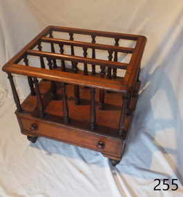
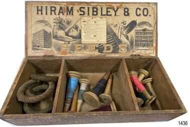
Container - Box for seeds, ca. 1880s
This seed box was made for Hiram Sibley for his seed house business. He sold seeds priced by the weight or the space they took up e.g. bushel. This box allowed for seeds to be divided by type, size or even date. The box was strong and easy to cart and store. It was also a handy item to 'recycle' as a storage container for other items. The Sibley seed box is a desirable collectors' item. A large variety of sizes and shapes are still available today in various stages of condition. Hiram Sibley developed seeds that were strong and the plants that grew from these seeds produced many seeds. Varieties of Sibley seeds and plants are still advertised for sale in modern times. HIRAM SIBLEY (1807-1888) - Hiram Sibley was born in America. He had a natural mechanical ability and became skilled in many trades. He and his partner Don Watson opened a sawmill then a machine shop and foundry. He became involved with Alfred Vale and Samuel Morse and their work on the telegraph. Eventually he became the first president of the Western Union Telegraph Company. Later, after leaving Western Union in the early 1860s, Sibley bought and sold railroads, manufactured sold, ran timber mills, and became involved in farming and seed supply. In this area he used his skills to engineer seeds that were stronger and develop plants that produced more seeds. The production of seeds became his main business. He bought land cheaply and improved to soil so that he could produce seed and grain, and graze herds of cattle. He became the owner of 14 large farms. Hiram Sibley earned the reputation "as the most extensive farmer and seedsman in this country". The business of Hiram Sibley & Co. was conducted his warehouse in Rochester and his seed house in Chicago. One department of the business sold farming equipment, another department imported ornamental plants from overseas countries Sibley went on to invest a large amount of money in a bank, and to be financially involved in the community by making large donations to public services such as a library and a school of music. At one point he was the richest man in Monroe county.This box is significant for its historic connection with Hiram Sibley, who is famous for many reasons, among which is his very profitable business of seed engineering to improve the production of crops. This box also represents the value of containers used for selling products in the 1880s, being re-used for other useful purposes. The box is an example of goods imported for use in Australia. The text and images of the box are an example of 1880s advertisingBox, wooden, with two brass hinges joining lid to base. Base has two wooden partitions, divided into three unequal sized compartments. Lid's underside has label with drawings of buildings and produce, text with maker's name and description of vegetables. Front edge of box has stencilled text and diagrams. Outside lid, and the other three sides, have no inscriptions. Made by Hiram Sibley & Co., USA. (Box is currently used to store quoits 1436.2 and cones of cotton thread 1436.3.)Marked "HIRAM SIBLEY & CO / SEEDS", "WAREHOUSE - "ROCHESTER N.Y. ", "SEED HOUSE - CHICARGO, ILL.", "SEEDS BY WEIGHT & MEASURE", "PUT UP BY / HIRAM SIBLEY & CO. / ROCHESTER, N.Y. AND CHICARGO, ILL."flagstaff hill, warrnambool, maritime village, maritime museum, flagstaff hill maritime museum & village, hiram sibley & co, rochester n.y., seeds, wooden seed box, seed box, seedsmen, arable farming, chicargo illinois, seed house, seed engineering, seed distribution, seeds by weight and measure -
 Puffing Billy Railway
6 NB - Saloon carriage, 22/ 8/1904
NB Class - Number Built (1st Series) 6 - Number Built (2nd Series) 17 - Number Built (3rd Series) 4 6 NB - Saloon carriage (24) Body Length 20 feet 6 inches ( 6248 mm) Vehicle Length 25 feet 2 inches ( 7671 mm) Coupled Length 27 feet 4 inches (8330 mm) Width 6 feet 3 inches (1905 mm) Height 9 feet 5 inches (2870 mm) Weight 8 tons Capacity 16 passengers Built 1898 - 1904 Number Built 6 In use NB 1. NBD 2, 5 Awaiting restoration NB 6 VR Service History NBB 6.VA - 22/ 8/1904 NWS Built new - circa 1910 - To NB 6.VA - *NB 6.VA - / 4/1926 - Modified AC Malco 4/ 3/1938 - Scrapped - Puffing Billy Service History or Notes NB (first series) NB - There were three types: -Nos. 1-6 were Saloon cars having end platforms and a ladies toilet, and were built from 1899-1904. Nos. 7-23 were 5-compartment side loading cars, built from 1906-1915. Nos. 24-27 were the former NAB class cars mentioned previously and were also side loading, having 6 compartments and two ladies toilets. Rescued by the Puffing Billy Preservation Society from Ocean Grove Victorian in Nov 2010 Nov 2010 Two carriages have been rescued from Ocean Grove where they had been built into a house. They are now at Emerald, one being a platform NB carriage and the other a swing door NB carriage. Storage of these vehicles is being considered. Many people were involved in the move: thanks go to Raymond and Thelma Cotter for providing tarps to protect the cars from the elements. Dec 2010 Two carriages rescued from Ocean Grove are now at Emerald, one being a platform NB car (6NB) and the other a 2nd Class swing door carriage. Minor refurbishment has taken place along with covering with Tarpaulins.Historic - Victorian Railways Narrow Gauge - Passenger Rolling Stock: Saloon carriagePassenger Rolling Stock: Saloon carriage 6NB - Made of Timber. 6 NBpuffing billy railway, pbr, rolling stock , 6 nb, puffing billy, 6nb, saloon carriage, victorian railways, narrow gauge passenger rolling stock, 2'6" guage -
 University of Melbourne, Tiegs Museum of Zoology
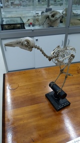
Grey Currawong (Strepera versicolor) mounted skeleton, Mid to late 19th century
The museum register is somewhat ambiguous but it is recorded - along with about 12 others - that this specimen was transferred from the 'Nat. Sc. Dept' in September 1899. The specimen also apparently has something to do with Frederick McCoy; his name is entered as the party that identified the skeleton. It seems certain that these were a batch (accession numbers MUZD1113-1126) of specimens given to the university teaching museum during the move of the state museum from the university campus to its subsequent site on Russell St. Examination of the Currawong skeleton (and some of the others in this batch) revels that the specimen has been remounted at some point. The other items in this batch are, like this specimen, predominantly mounted articulated vertebrate skeletons: [Specimens are listed with accession number and name as written in the original register] MUZD1113 - 'Lepus timidus' (Mountain hare), mounted skeleton; currently on display in the Tiegs Zoology Museum MUZD1114 - 'Emydura' (Short-necked Turtle), mounted skeleton; currently on display in the Tiegs Zoology Museum MUZD1115 - 'Astur novaehollandiae' (Obsolete binomial name for Accipiter novaehollandiae - Grey Goshawk); mounted skeleton, currently in storage, disassembled, in the Tiegs Zoology Museum. MUZD1116 - 'Grey crow-shrike ♂' (Grey Currawong), mounted skeleton; currently on display in the Tiegs Zoology Museum MUZD1117 - 'Herpestes, India' (Mongoose sp.), mounted skeleton; currently on display in the Tiegs Zoology Museum MUZD1118 - 'Macropus giganteus (aged[?]), Goulburn River' (Eastern Grey Kangaroo), ♀ skull; whereabouts unknown MUZD1119 - 'Macropus giganteus, ?' (Eastern Grey Kangaroo), skull; whereabouts unknown MUZD1120 - 'Raia ? lemprieri' (Obsolete binomial name for Dentiraja lemprieri -Thornback Skate), stuffed; whereabouts unknown MUZD1121 - 'Cyprinus carpio' (Common carp), skeleton - roughly prepared; whereabouts unknown MUZD1122 - 'Ovis' (Domestic sheep probably Jacob Sheep, '4 horned breed'), skull; whereabouts unknown MUZD1123 - 'Cervus canadensis (Wapiti)', skull and lower jaw - no horns; currently on display in the Tiegs Zoology Museum MUZD1124 - 'Antelope', no further information; whereabouts unknown MUZD1125 - 'Encope emarginata' (Echinoderm), currently on display in the Tiegs Zoology Museum MUZD1126 - 'Heterocentrotus trigonarius' (Pencil urchin), currently on display in the Tiegs Zoology Museum (accession number is not written on wooden base, but on the inside of the specimen.)Mounted skeleton of Grey Currawong (Strepera versicolor). Skeleton is mounted on a black wooden stand with a round base.Accession number '2259' is written in ink on the sternum. Wooden mount has black label with white text on the base reading 'GREY CROW SHRIKE/ STREPERA VERSICOLOR'. animal, vertebrate, bird, skeleton, frederick mccoy, national museum of victoria, passeriformes, artamidae -
 Flagstaff Hill Maritime Museum and Village
Functional object - Copper Sheet, circa 1878
In 1984 the Commonwealth Government made available to Flagstaff Hill a collection of lead ingots and copper sheets recovered from the wreck-site of the LOCH ARD. They were presented to the Warrnambool City Council by the Hon. Tom Uren MHR, Minister for Territories and Local Government: “The Commonwealth recognises that shipwrecks like the LOCH ARD are our national heritage with important educational, recreational and tourist applications” (The Standard, Tuesday 8 May 1984). The LOCH ARD was wrecked in 1878. Unsuccessful salvage operations were then undertaken with the 90 ton paddle steamer NAPIER. In sudden bad weather this vessel too was sunk. The precise position of the LOCH ARD in the exposed and dangerous waters off Mutton Bird Island became lost to memory. The underwater location of the LOCH ARD was rediscovered in 1967 by a Warrnambool skindiver, Stan McPhee. In the two years following his find, the vessel was systematically pillaged by unauthorised salvagers. This led to the State and Federal Governments’ intervention in 1969. A roundup and seizure of recovered lead ingots and copper sheets was conducted by Commonwealth and Victorian Police. Offenders were charged and convicted. The “repossessed loot of the Tassie Boys” was placed into secure storage (Jack Loney, 1978, Wrecks & Reputations). The LOCH ARD manifest of cargo lists “Pig lead 50 tons, 994 pig & 37 rolls” and “Copper 33 plates, 53 bolts”. While the lead ingots have been subsequently described as “ballast”, the copper sheets are unlikely to have been associated with the ship’s normal complement in that way. Similar product lines in the cargo manifest are “Bar and rod iron 102 tons”, “Plate iron 3 tons” and “Zinc 12 tons”. These raw materials were used by colonial artisans such as blacksmiths and metal smelters to fashion, and repair, agricultural implements and industrial machinery. Copper was valued for its non-corrosive properties and its malleability, or ease of working. Both these qualities were useful, for example, in laying underground gas pipes that supplied lighting to residences, businesses and streetscapes in the mid-nineteenth century. As the nineteenth century progressed, the metal was also increasingly valued for its conductivity, with copper wiring linking colonial communities to each other, and the wider world, via the Telegraph system. The average weight of the copper sheets is 216 kilograms, calculated by "volume 0.1936m³ X Cu density 8930kgs/m³".The shipwreck of the Loch Ard is of significance for Victoria and is registered on the Victorian Heritage Register ( S 417). Flagstaff Hill has a varied collection of artefacts from Loch Ard and its collection is significant for being one of the largest accumulation of artefacts from this notable Victorian shipwreck. The collections object is to also give us a snapshot into history so we can interpret the story of this tragic event. The collection is also archaeologically significant as it represents aspects of Victoria's shipping history that allows us to interpret Victoria's social and historical themes of the time. The collections historically significance is that it is associated unfortunately with the worst and best-known shipwreck in Victoria's history. Large heavy sheets or panels of copper metal raised from the wreck of the LOCH ARD. The 10 sheets are of roughly similar dimensions and rectangular shape. They bear signs of prolonged submersion in seawater, with various degrees of limestone accretion, adhered marine growth, and green oxidisation. Three of the sheets are severely buckled, demonstrating the force of underwater explosives used in their salvage. One sheet appears cut or severed in a diagonal line downwards from its top left hand corner. One sheet has a 10cm X 10cm square cut out of its top right hand corner. All sheets are in sturdy, stable condition. No maker’s marks are visible.flagstaff hill, warrnambool, shipwrecked coast, flagstaff hill maritime museum, flagstaff hill maritime village, great ocean road, loch line, loch ard, captain gibbs, eva carmichael, tom pearce, glenample station, mutton bird island, loch ard gorge, sailing ship, copper sheet, manutacturing materials, metal imports, muntz -
 Eltham District Historical Society Inc
Slide - Photograph, Monument with time capsule, Eltham Community Centre, Main Road, Eltham, c.1997
The monument with time capsule was established by the Shire of Eltham Historical Society to commemorate Victoria’s 150th anniversary and mark the former location of the Eltham Town Centre, which existed along this section of Main Road, then known as Maria Street. The unveiling was conducted 10 November 1985 by Cr. Mary Grant (Shire President). The monument was constructed with a concrete base and the main feature is an old tyring plate or disc. The Time Capsule Ceremony involved lowering the sealed time capsule into place, bolting down its container lid and then concreting over the lid. The capsule contains items relating to present day (1985) Eltham and its people including a video film made by Joh Ebeli and also details of families and organizations who have contributed to construction of the monument. It is to be opened in the year 2035. The Society received an excellent response from local people, firms and organizations by way of assistance with this project. Graham Beyer, who originated the project, arranged many of the donations. He and his firm, Package Handling Equipment, donated the time capsule itself and carried out fabrication of sections of the monument. The design of the monument was adapted by Graham Beyer from drawings by Joh Ebeli. Charmac Industries donated the container for the time capsule and a cast gun metal name plate for the monument. BMG Concrete donated concrete for the base which was constructed by Caridi Construction Company. Northbourne Garden Supplies donated materials for the paving around the monument. Robert Becker from Eltham Apex directed construction of the paving by Society members. Terry Hutchinson donated the use of his crane to lift the tyring disc into place. Financial contributions were also made by the Eltham Chamber of Commerce and the Rotary Club of Eltham. In 1987 in commemoration of the Society’s 20th Anniversary, Joh Ebeli suggested the commissioning of a plaque to be added which explains the functions of the various items used in the Society’s Victorian 150th Anniversary Monument and this was unveiled by its designer, Joh Ebeli, on October 10, 1987. Circa 2010-2012 the monument was damaged through vandalism. The mounts for the ring had been broken. At the time of this photo the ring had been removed by Jim Connor, President of the Eltham District Historical Society and placed in safe storage whilst arrangements were made with Neil Carter of Carter Art, Research to undertake the repairs.Colour printeltham, eltham community centre, monument, public art, time capsule, carter art, neil carter -
 Glen Eira Historical Society
Album - Album page, Old Fire Station, 4 Selwyn Street, Circa 1972
This album was created in approximately 1972 as part of a project by the Caulfield Historical Society to assist in identifying buildings worthy of preservation. The album is related to a Survey the Caulfield Historical Society developed in collaboration with the National Trust of Australia (Victoria) and Caulfield City Council to identify historic buildings within the City of Caulfield that warranted the protection of a National Trust Classification. Principal photographer thought to be Trevor Hart, member of Caulfield Historical Society. Most photographs were taken between 1966-1972 with a small number of photographs being older and from unknown sources. All photographs are black and white except where stated, with 386 photographs over 198 pages. From Victorian Heritage Database citation for H2376 Former Elsternwick Fire Station, 2-4 Selwyn Street Elsternwick - Victorian Heritage Register https://vhd.heritagecouncil.vic.gov.au/places/2645 (as at 21/11/2021) The Former Elsternwick Fire Station was built and commenced operation in 1896. It was one of 32 new fire stations built between 1892 and 1896 by the newly formed Melbourne Metropolitan Fire Brigade ('MFB') to form a comprehensive fire-fighting network across Melbourne. The MFB was established in 1891 as Victoria's government-run fire-fighting service in Melbourne and its growing suburbs. By 1918 motorised fire engine appliances had replaced horse-drawn fire vehicles across the metropolitan area, and the consequently larger areas that fire stations could protect meant the 1896 Elsternwick Fire Station was one of many which was becoming obsolete. The MFB continued to use the Elsternwick Fire Station up until the Station's closure in 1926. From 1927 the former Fire Station was leased by neighbouring timber merchants JJ Webster Pty Ltd who subsequently purchased the property from the MFB in 1934. From 1954 the 'Esquire Motors' car repair business traded at the site, and changes to the former Fire Station building including the complete enclosure of its yard by corrugated steel walls and roofing appear to have been completed in the mid-1950s. In 1990 the Australian Broadcasting Corporation ('ABC') purchased the former Fire Station together with five other adjoining land parcels in Selwyn Street. From that time until 2017 the former Elsternwick Fire Station has been used by the ABC as office and storage space in its Selwyn Street television studio complex.From Victorian Heritage Database citation for H2376 Former Elsternwick Fire Station, 2-4 Selwyn Street Elsternwick - Victorian Heritage Register https://vhd.heritagecouncil.vic.gov.au/places/2645 (as at 21/11/2021) The Former Elsternwick Fire Station is historically significant as one of the 10 remaining fire stations of the original 32 built for the newly established Melbourne Metropolitan Fire Brigade ('MFB') during the four-year period 1892 to 1896. These fire stations were constructed following the establishment in 1891 of the MFB, Victoria's government-run fire-fighting service for metropolitan Melbourne and its growing suburban population. These new stations formed a crucial part of the MFB's fire-fighting network across Melbourne. The Former Elsternwick Fire Station clearly demonstrates the historical development of fire-fighting services in Melbourne, especially the expansion of the newly-formed MFB throughout Melbourne's suburbs during the 1890s. [Criterion A] The Former Elsternwick Fire Station is architecturally significant as a fine example of a late nineteenth century fire station. Constructed shortly after the establishment of the MFB, it displays characteristics of its class of place that remain mostly unchanged from the former Station's historically important period of development and use. A particularly strong element of the Former Elsternwick Fire Station is the large and strikingly-detailed stone horseshoe arch, designed for horse-drawn fire-fighting vehicles, at the street entrance to its fire-engine room. [Criterion D]Page 188 of Photograph Album with two photographs of the old Elsternwick Fire Station.Handwritten: old fire station 4 Selwyn Street [top right] / 188 [bottom right]trevor hart, rendered, 1890's, melbourne metropolitan fire brigade, mfb, fire-fighting, jj webster, timber merchants, esquire motors, car repair, australian broadcasting corporation, abc, selwyn street, brick and stone, asymmetrical facade, anglo-dutch gable, rusticated and smooth-faced limestone, elsternwick fire station, elsternwick, fire station, jj webster pty ltd, motor vehicle repair shops, stone horseshoe arch entrance -
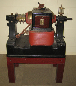 Federation University Historical Collection
Equipment, Elwell-Powell, Elwell-Parker AC Generator
This AC generator operated for the State Electricity Commission in the Ballarat North Power Station prior to World War Two. James Oddie of Ballarat has an association with Thomas Parker of Elswell-Parker. In early 1887 Oddie arrived in England seeking information on electrical knowledge and its developments. At this time Henry Sutton was teaching Electricity and Magnetism at the Ballarat School of Mines. Oddie stayed in the United Kingdom for around three years and during that time became a close friend of Thomas Parker and his family. The two first met at the first official running of the Blackpool tram, and Oddie was invited to visit Parker at Wolverhampton. Over the years Thomas Parker kept newspaper cuttings (mainly Australian) relating to James Oddie and his work. The following article is a description of the Wolverhampton works by James Oddie, and was collected by Thomas Parker. After the dinner at Blackpool, Mr. Parker visited me, and cordially invited me to see his extensive works at Wolverhampton, an invitation I was not slow to avail myself of. This was the keynote of the best friendship I made in England. I went shortly afterwards and stayed several days, visiting the works daily, as Mr. Parker gave me the run of the whole works. There I ordered the installation of a 60 light dynamo, with a 28 cell storage battery and paraphernalia, now doing duty at the Observatory. I subsequently visited the works frequently, sometimes for a week at a time, and I regard it as the brightest spot in my English constellation. Mr. Parker started his works in 1880, with one man beside himself. He never had a single day’s instruction in electricity in his life; now he daily instructs between 300 and 400 employees, who worship him as a father. He is said to be now the most practical electrical engineer and mechanist in Europe. During one of my visits I took with me an artist, who is painting for me a portrait, 6 feet by 5 feet, of Mr. Parker, surrounded by dynamos, secondary batteries, measuring instruments etc. Electric tram cars are going to be a big thing in England. Parker’s Company Limited, is now, with three other companies, in the hands of the Electric Construction Company, with Mr. Parker as manager of the lot. The whole of the works will be taken to Wolverhampton. Before I left, a tender for £50,000 was accepted for the construction of new works.AC Generator painted read and black on a stand. This AC generator operated for the State Electricity Commission in the Ballarat North Power Station prior to World War Twogenerator, ac generator, elwell-parker ltd, state electricity commission, sec, ballarat north power station, james oddie, wolverhampton -
 Flagstaff Hill Maritime Museum and Village
Functional object - Latch, before 1890
In Flagstaff Hill’s collection are items associated with the Ancient Wreck, (also called the Gold Ship, Mahogany Ship or Ancient Vessel). Three relics were located in 1890, due to the ‘interest of a public works inspector, James Gilroy, who dug in the ship’s remains’. One of the relics was a heavily oxidated ‘quantity of ironwork’. The other two, now part of Flagstaff Hill’s collection, are - an iron latch probably from a galley oven door or fireplace - a bronze bolt (spike or pin) Both of these relics are listed on the same page in the records of the Old Warrnambool Museum, found by K.A.G. (or H.A.G.) on the site of the Ancient wreck in 1890. Interestingly, another item in these records is ‘Notes on Ancient wreck, near Gorman’s Lane’. Gorman’s Lane is just inland from the sand dunes of the Coastal Reserve at Tower Hill. The current location of these Notes is unknown. Another item thought to be a relic from the Mahogany Ship was the amphora or jug, also in Flagstaff Hill's collection. It was found in 1934 on a local property and donated in 1985. The Museum opened in 1886 and continued until 1963, when it was closed by the Warrnambool City Council and the whole collection was put into storage. The council then transferred items to various places including Flagstaff Hill and the current Warrnambool Art Gallery. Flagstaff Hill’s early Accession Records book lists the items as being received from the Old Warrnambool Museum collection; the Latch is record 152 and the Pin is record 153. An article, ‘Birthplace of our History’ by Don Dean, is on file in the Warrnambool and District Historical Society. It was published in the Australian POST, on March 17, 1955. This article describes the finding of the items going back to 1890, along with other information about sightings of what has come to be known as the Mahogany Ship. The mystery of the Mahogany Ship began in 1836 when two shipwrecked sealers discovered the remains of an “ancient vessel” in the sand dunes about four miles west of Warrnambool. Since the last recorded sightings in the 1880’s the true origin of the Mahogany Ship has remained one of Australia’s most famous historical mysteries. One of the more recent theories is that the vessel was one of the Portuguese ships exploring the Australian coast in 1522. For over one hundred years searchers have attempted to locate and identify the wreck. The search continues for the tangible evidence which will once and for all establish the Mahogany Ship’s place in Australia’s History. The latch has local historic significance as it was found in the sand dunes of Warrnambool in 1890. The latch is also significant for being part of the original 1886 Warrnambool Museum's collection. The latch is significant for its possible link to one of Victoria’s and Australia’s maritime mysteries, the Mahogany Ship (also known as the Ancient Wreck). It is one of very few known relics that could give evidence of the existence and history of the vessel. It is listed on the Victorian Heritage Register S438 as it is one of Victoria’s oldest recorded shipwrecks. The identity of the vessel has the potential to change Australia’s history.Latch, iron. Flat iron latch tapers inward from loop handle to narrow end with prongs. Handmade. warrnambool, shipwrecked coast, flagstaff hill maritime museum, shipwreck coast, mahogany ship, latch, relic, old warrnambool museum, ancient vessel, ancient wreck, oven latch, fireplace latch, galley oven, gold ship, gorman's lane, coastal reserve, tower hill -
 Flagstaff Hill Maritime Museum and Village
Functional object - Bolt, before 1890
Flagstaff Hill’s collection has items that are thought to be relics from the Ancient Wreck, (also called the Gold Ship, Mahogany Ship or Ancient Vessel). Three relics were located in 1890, due to the ‘interest of a public works inspector, James Gilroy, who dug in the ship’s remains’. One of the relics was a heavily oxidated ‘quantity of ironwork’. The other two, now part of Flagstaff Hill’s collection, are - an iron latch probably from a galley oven door or fireplace - a bronze bolt (spike or pin) Both of these relics are listed on the same page in the records of the Old Warrnambool Museum, found by K.A.G. (or H.A.G.) on the site of the Ancient wreck 1890. Interestingly, another item in these records is ‘Notes on Ancient wreck, near Gorman’s Lane’. Gorman’s Lane is just inland from the sand dunes of the Coastal Reserve at Tower Hill. The current location of these Notes is unknown. Another relic is thought to be the amphora, discovered in 1934 on a local property. The Museum opened in 1886 and continued until 1963, when it was closed by the Warrnambool City Council and the whole collection was put into storage. The council then transferred items to various places including Flagstaff Hill and the current Warrnambool Art Gallery. Flagstaff Hill’s early Accession Records book lists the items as being received from the Old Warrnambool Museum collection; the Latch is record 152 and the Pin is record 153. An article, ‘Birthplace of our History’ by Don Dean, is on file in the Warrnambool and District Historical Society. It was published in the Australian POST, March 17, 1955. This article describes the finding of the items going back to 1890, along with other information about sightings of what has come to be known as the Mahogany Ship. The mystery of the Mahogany Ship began in 1836 when two shipwrecked sealers discovered the remains of an “ancient vessel” in the sand dunes about four miles west of Warrnambool. Since the last recorded sightings in the 1880’s the true origin of the Mahogany Ship has remained one of Australia’s most famous historical mysteries. One of the more recent theories is that the vessel was one of the Portuguese ships exploring the Australian coast in 1522. For over one hundred years searchers have attempted to locate and identify the wreck. The search continues for the tangible evidence which will once and for all establish the Mahogany Ship’s place in Australia’s History. The bolt has local historic significance as it was found in the sand dunes of Warrnambool in 1890. The bolt is also significant for being part of the original 1886 Warrnambool Museum's collection. The bolt is significant for its possible link to one of Victoria’s and Australia’s maritime mysteries, the Mahogany Ship (also known as the Ancient Wreck). It is one of very few known relics that could give evidence of the existence and history of the vessel. It is listed on the Victorian Heritage Register S438 as it is one of Victoria’s oldest recorded shipwrecks. The identity of the vessel has the potential to change Australia’s history.Bolt, also referred to as spike or pin. Bronze bolt, round body with head on one end that has straight sides, tapers to a point at the other end.warrnambool, shipwrecked coast, flagstaff hill maritime museum, shipwreck coast, mahogany ship, relic, pin, spike, old warrnambool museum, nail, ancient vessel, ancient wreck, portuguese ship, gold ship, gorman’s lane, coastal reserve, tower hill -
 Puffing Billy Railway
8 NB - Compartment Passenger Carriage, 1906
8 NB - 6 compartments (40) Victorian Railways Service History 8 NB - passenger carriage (PBPS Body only - currently no underframe) 21 Dec 1906 Built New at Newport Workshops - numbered classed as NBB 8. Type: 2nd Class swing door carriage - 5 or 6 compartments 2'6" Bogie [8W]: Eight Wheels (2 x Four Wheel bogies) [CDG]: Continuous Draw Gear [WHB]: Westinghouse Brake circa 1910 - reclassed to NB 8 May 1926 - Modified with Automatic Couplers Malco Oct 1928 - Modified with Automatic Couplers Malco Bottom Operated 16 Dec 1937 - Consigned as to be scrapped 19 Feb 1938 - Condemned 4 Mar 1938 - Scrapped & Broken Up - Condemned Rolling stock Book Body to be offered for sale & underframe & bogies retained for use in construction of any additional NG trucks undertaken in near future. Sold by V.R and privately bought and used in the construction of a house at 80 Dare Street, Ocean Grove Puffing Billy Preservation Society Service History or Notes Sept 2010 - Ocean Grove house demolition results in PBPS being contacted that there were two carriages (6 NB & 8 NB) in the house. PBPS arrange to buy the two carriages bodies from the Demolition company Nov 2010 - Two carriages have been rescued from 80 Dare Street, Ocean Grove where they had been built into a house. Many people were involved in the move: thanks go to Raymond and Thelma Cotter for providing tarps to protect the cars from the elements. Dec 2010 - Two carriages rescued from Ocean Grove are now at Emerald, one being a platform NB car (6NB) and the other 8 NB a 2nd Class swing door carriage. Minor refurbishment has taken place along with covering with Tarpaulins. 29 Jan 2020 - 8 NB - passenger carriage - Body only is moved by the PBPS Heritage Rolling Stock Committee from Emerald Station sidings and placed into storage in a warehouse at Officer to enable it to be investigated into its possible restoration. 29 Feb 2020 - investigation on the carriage by the PBPS Heritage Rolling Stock Committee found the number of the carriage 8 NB stamped on the inside of the side of the windows frames. Current - At OfficerNB Class - Number Built (1st Series) 6 - Number Built (2nd Series) 17 - Number Built (3rd Series) 4 Historic - Victorian Railways Narrow Gauge - Passenger Rolling Stock: Passsenger carriage. 14 NB and this carriage (both of the 2nd Series) are the last known existing vehicles of this type out of the 17 built - maybe!.Passenger Rolling Stock: ? NB - Passenger carriage - Made of Timber NB - 2nd Class swing door carriage - 5 compartments number unknown ? NB puffing billy, nb passenger carriage, victorian railways, narrow gauge passenger rolling stock, 2'6" gauge -
 Ballarat Tramway Museum
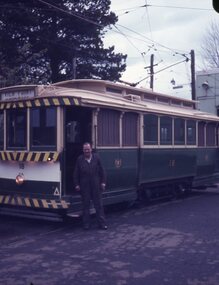
Slide - 27 mm sq slide/s - set of 22 - moving 18 to Sebastopol, Lilian Butler, 30/09/1971
Yields information about the transfer of tram 18 to Victory Park Sebastopol.Set of 22 Agfa blue and white plastic mount slides of tram 18 being moved to Victory Park for the Borough of Sebastopol - 30/9/1971. See Reg Item 2909 for the actual Newspaper cutting and 3778 for a photograph of the move. See Reg Item 3929 for list of dates of tram disposal, though this item gives the date as 2/10/71 .1 - No. 18 parked on the depot fan, with E. Davis alongside. .2 - group of 6 men standing alongside 18 - left to right - N. Lorensini, ? W. Trusler, S. Lakey, B.Peart and E. Davis .3 - tram being driven into Wendouree Parade. .4 - ditto .5 - turning from Macarthur St into Drummond St south with a SEC bucket truck following. .6 - ditto - with the Lisette Beauty Salon on the corner. .7 - Drummond St North .8 - Coupling a SEC tractor to the tram with the Ballarat Base Hospital in the background. .9 - Ditto with S. Lakey cleaning out the points. .10 - being towed across Sturt St .11 - being towed along Drummond St South .12 - workmen at Victory Park preparing the section of track. .13 - ditto .14 - being derailed near Vickers St with an Alsco Linen Service van in the background - note the overhead appears to have been removed. .15 - towing the tram across Albert St. .16 - towing the tram along Victory St, .17 - ditto .18 - moving steel channel along the street, with a tram sitting on one already. .19 - moving the tram .20 - ditto .21 - turning the track to align up with the storage track. .22 - Group of 7 men (see slide 2 for some of the names) and three children with the tram in position. Photo from the collection of Lilian Butler. See also Reg Item 6857 for a digital image. ballarat, tramways, trams, sec, depot, tram disposal, sebastopol, victory park, albert st, moving trams, drummond st, macarthur st, tram 18 -
 Bendigo Historical Society Inc.
Document - DRAINAGE PROBLEMS - MINERS SENSATIONAL EXPERIENCE AT THE VICTORIA QUARTZ
Handwritten notes from a Bendigo Advertiser report, Thursday June 16th 1910. Management had for some time been apprehensive that the flooding in the deep mines to the south would affect them. Lansell's 180 took the precaution of baling. On the Tuesday night the men at the Victoria Quartz had a sensational experience. The storage dam at 3324 ft level receives the overflow from the flooded mines to the south. The level connects with the 3310 level at the Big 180. The water flows uninterrupted into thestorage dam which has a capacity of about 270 tanks. The dam had been emptied on Tuesday morning and work continued until 10 pm that night. The platman noticed that the water was coming down the shaft in a regular torrent. They didn't take much notice as they thought it was a leakinig outlet valve on the ascending tank. At 11 pm the releiving shift came down the shaft and said that the dam at 3,324 ft must be overflowing. The velocity of the water pouring down the shaft increased and the men made a hurried exit from the bottom of the shaft which is down 310 ft from the 4.254 ft plat (a total depth of 4,564 ft). An inspection of the dam at the 3324 ft level found it to be overflowing. By morning (Wednesday) the shaft had filled, and the water rose to 7 ft in the plat at 4254 feet. Mining inspector hgave orders that men were not to go below the 3324 ft level. Baling continued without cessation at the Big 180 all day and could not lower the water. Drilling machines etc and a powerful air winch at the 4254 ft plat are under water. An inspection made of the 3100 ft level at the 180 mine where the workings are connected with the New Chum & Victoria showed that water was running strongly from that mine proving that the inrush was due to flooded water from the southern deep mines to the south. Document from Albert Richardson Collection of mining history. Document from Albert Richardson Collection of mining history.document, gold, drainage problems, new chum drainage scheme, miners sensational experience at the victoria quartz, bendigo advertiser 16/6/1910 page7, lansell's 180, big 180, new chum & victoria -
 Eltham District Historical Society Inc
Photograph, Liz Pidgeon, Public Records Office Victoria (PROV) visit to Eltham Justice Precinct, 20 Apr 2018
The original Shire of Eltham was founded in 1871. Prior to its founding, the district was managed by the Eltham District Road Board, which was established in 1856. The initial rate assessment commenced in 1857 for the year ending October 14, 1858. The honour of being recorded with the first assessment went to a farm of 110 cultivated acres at Lower Plenty, owned by John Porter and occupied by Albert Baines. It was assessed at 6d/acre providing for a rate income of £2 15s. In July 2017, officers at Nillumbik Shire Council discovered some early Eltham Road District Assessment books and donated them to the Eltham District Historical Society. The seven volumes were the district’s first six years of rate assessments. This was a unique and significant record of early settlers in the pre-Shire of Eltham. They immediately became one of the oldest and most valuable items in our collection. An article on page 5 in the Eltham and Whittlesea Shires Advertiser, Friday, 21 November, 1941 titled: ‘District’s Early History‘ states: “The first rate book which is still in existence at the Shire Office is for the year ending October 14, 1858 and is probably the best record possible to indicate the development of the district. At the time properties were rated as follows: Cultivated land. 6d. per acre; pasture land, 1d. per acre: estimated annual value of buildings, etc., 6d in the (pound). The total amount of rate recorded for the year was £153/14/8. Properties were described as being situated at Lower Plenty, Yarra Yarra, Eltham, Lower Eltham, Kangaroo Ground, Yarra Flats, Diamond Creek and the Yarra.” Given the precious nature of this collection, priority was given to digitise the rate books and place them in suitable archival storage to minimise further handling. Subsequent discussion amongst our Collections team arrived at the conclusion that the most appropriate home for this valuable record was the Public Record Office Victoria (PROV), the archive of the State Government of Victoria and who are charged with archiving and caring for all Government related records. An approach was made to PROV who confirmed these records would complete their collection of rate assessment books for Eltham. At a small ceremony held Friday, April 20 at the Local History Centre, Eltham, members of the Society and our Collections team, along with Ms. Vicki Ward, MP for Eltham, presented the seven volumes for 1858-1863 along with the complete set of digital files to Mr. David Taylor, Community Archives Manager and Mr. Charlie Farrugia, Senior Collection Advisor, Public Record Office Victoria.Born Digitalassessment ledger, donation, eltham courthouse, eltham road district, local history centre, public records office victoria (prov), rate books, eltham district road board -
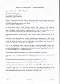
 Mission to Seafarers Victoria
Instrument - Reed organ, W Bell & Co, c. 1888
This organ was gifted by the Bethel Community in 1890 to the then Victorian Seamen's Mission, originally founded by the Bethel Union in 1857. The gift was intended to assist with worship. Despite all appearance, this organ is not a pipe organ but a reed organ that works in a similar manner to an accordion. In May 1890, the sum of seventy pounds was put towards the purchase of the organ. The sum being raised via subscriptions. The organ was inaugurated in September 1890. Jabez Carnegie (1832-1892), importer of piano and organs in Melbourne, had made a trip to Europe and Canada in 1887 and had secured the agency of Bell organs. W. Bell & Co were a Canadian organ and piano manufacturer, considered the premier organ manufacturer of the time. W Bell & Co changed its name to Bell Organ and Piano Co in 1888 meaning this organ had to be manufactured prior to the name change. The organ was first used in the mission main room from 1890 to 1915 when the St Nicholas chapel was built at the back (see item 0548. It was transfered to the new Port Melbourne mission in 1937 (link on postcard from State Library Victoria). In 1972, it was transferred to the Holy Trinity Church in Bay Street after the closure of the Mission In the late 1980s during a National Trust campaign to save the building, the organ was sold by the Anglican Men's Society to the Trust's organ committee, who carried out some restoration work and returned it to the former Missions to Seamen chapel. In 1991 the Office of Major Projects had control of the whole 'Bayside' development site. With the Mission to Seamen Building emptied and proposed for demolition, the Office of Major Projects removed the organ and placed it in storage in various locations - finally, in the Museum of Victoria store in Abbotsford. In 1995-6, enquiries by Jim Hillis resulted in the return of the organ to the control of the Port Melbourne HIstorical & Preservation Society. As the Society had no suitable location for the organ, several churches and schools in Port Melbourne were approached to take the organ with no results. The nearby suburbs were suggested next. Finally the Melbourne Maritime Museum (Polly Woodside) was approached and agreed to place it in their Museum on a long term loan. In 1997 it was on display in no 5 shed South Wharf (23/3/1997). In 2006, the Polly Woodside South Wharf site was to be re-developed, and they could no longer retain the organ. Accordingly, on 4 May 2006, the organ was transferred to the Mission To Seafarers building in Flinders Street Extension as an indefinite loan (refer OL 022) The PMHPS deaccessioned it to finally transfered it in 2018 to MTSV.(See also acquisition details re 21st C finalisation of acquisition) This organ is a tangible reminder of the longevity of the Mission to Seafarers, a link with the original Bethel Union which was instrumental in 1856 calling a public meeting and inviting subscriptions by various non-conformist churches to found a mission to Seamen. Rev Kerr-Johnson delivered the first service in 1857 aboard the Emily. The Mission to Seafarers has been in operation ever since and continues to operate to the same purpose today.Large reed organ that looks like a pipe organ with fifteen elaborately painted pipes bearing a floral motif. The body of the organ is elaborately decorated in carved wood. It has 17 knobs above the keyboard both which can be concealed when the keyboard cover is lowered. There are two foot pedals at the bottom of the organ with "Mouse Proof Pedals" cast into the framing iron. list of stop names: Viola 4Ft Diapason 8Ft Dolce 4Ft Violetta 2Ft Sub Bass 16 Ft Octave Coupler Vox Humana Forte Picciolo 2Ft Hautboy 8Ft Aeoline 8Ft Cremona 16Ft E---bone 16Ft Echo 8Ft Celeste 8Ft Melodia 8Ft Flute 4FtMaker's mark in gold lettering above keyboard: W. Bell & Co Brass plaque on front board: Presented to/The Victorian Seamen's Mission/by/Congregation worshipping in Bethel/& friends./1st September 1890 Behind the stops a wooden plaque: J. CARNEGIE & SONS, SOLE AGENTS FOR VICTORIA MELBOURNE organ, worship, bethel, pipes, reed, bethel union, pipe top, jabez carnegie, w. bell & co, port melbourne, mission to seafarers, seamens' mission, mission to seamen, guelph, ontario, canada, pmhps, polly woodside, harmonium, reed organ -
 Puffing Billy Railway
Greenbat Battery Loco, Greenwood & Batley ltd
Greenbat Battery Loco Built by Greenwood & Batley Ltd Builders No. 420363/2 This Greenbat Battery Loco has been loaned to the Museum by the Walhalla Goldfields Railway, who had acquired it in 2013 along with a large quantity of narrow gauge trollies and light rail from Orica’s now closed munitions factory in Melbourne’s western suburbs. The trolley on display was one of two in use from the 1970s. Orica - Deer Park Munitions factory Orica Deer Park in Melbourne’s west has been used since circa 1875 for various forms of manufacturing and storage of chemicals. Although the site is bounded by Ballarat Road, Station Street, Tilburn Road and the Western Ring Road, the current entry point for industrial operations is situated at Gate 6 off Tilburn Road. Operations include: • a specialty chemicals facility producing products for mining services operations • quarry services • other chemical manufacture activities. The Deer Park factory complex is of historical significance as the location of the first plant for the manufacture of high explosives in Australia and has been, for its entire history, the most important, if not only, commercial manufacturer of high explosives in Australia. It commenced operation under the importer Jones Scott and Co, and then the Australian Lithofracteur Company (Krebs Patent), a rival to Nobel's dynamite patent. The factory was producing nitro-glycerine based explosives in Australia only a couple of years after Nobel's Ardeer factory began operating in Scotland. The explosives factories complex is of historical significance for the association with the Australian Lithofracteur Company, Australian Explosives and Chemicals, the Nobel company and later ICIANZ, which grew to become one of the largest explosives, chemical and plastics manufacturers in Australia. It was the pioneer of the industry and retained its dominance through monopolistic practices, taking over most of its competitors in the Australasian region. Substantial parts of the pre-Second World War layout of the site remain which, with a number of significant buildings dating back to the 1920s and '30s, indicate past and present processes of manufacturing, the necessary safety measures required and the integrated nature of the explosives and chemical industry. The narrow gauge tramway, which ran through the explosives section, was a rare survivor of nineteenth century materials-handling methods into the 21st Century. Greenwood & Batley were a large engineering manufacturer with a wide range of products, including armaments, electrical engineering, and printing and milling machinery. They also produced a range of battery-electric railway locomotives under the brand name Greenbat. The works was in Armley, Leeds, UK. Greenbat was the trade name for the railway locomotives built by Greenwood & Batley. The company specialised in electric locomotives, particularly battery-powered types for use in mines and other hazardous environments. Historic - Industrial Narrow Gauge Railway - Battery Locomotive - Orica - Deer Park Munitions factory - Deep park, Victoria, Australia Battery Locomotive - made of iron puffing billy, greenbat battery loco, battery locomotive, industrial narrow gauge railway, orica - deer park munitions factory -
 Kew Historical Society Inc
Photograph, Frederick Harwood Noble and Winifred Noble, c.1890
One of five group and individual portraits of the Noble family of Kew, two in the rear garden of what is presumed to be ‘Charnwood’, in Station Street, Coburg. The photographs date from the period c.1890-1914. One of the larger framed photographs is a portrait of the entire family group, while another is of two of the children, Frederick and Winifred. The father, Frederick William Noble was a businessman, and, at one period Secretary of the Victorian Creamery & Butter Company in South Melbourne. Later he was to manage J. Bartram & Co., Ice & Cold Storage Department in Flinders Lane. By 1906, the Noble family had moved to Kew, living for almost 20 years at 100 Walpole Street before relocating to 26 Molesworth Street in the mid 1920s. The five photographs in the collection reveal details of family life and social values as expressed through attire. The family is formally costumed in a manner indicative of their social status. Mrs Noble, in one of the large framed portraits, is dressed in a sombre manner in a long, dark-coloured long-sleeved, high-necked gown. It is difficult to know whether she is dressed in mourning wear in this black and white photograph. It was not uncommon for a woman to regularly wear mourning attire due to the high mortality rate in the Victorian era. This situation was compounded for women due to the size of extended families. A woman might rarely be out of mourning due to the death of a parent, a sibling, a husband, a child or a near relative. The portraits of the Noble family children, particularly Frederick and Winifred, show the elaborateness of formal attire worn by the children of wealthy families during the late Victorian era. Winifred is dressed in a long cotton dress and a broad-rimmed hat; both liberally covered in lace. Winifred and Frederick’s lace collars extend to their shoulders. Winifred’s diaries, covering the period 1908-50, are now in the collection of the State Library of Victoria. The most detailed of the diaries is from 1914, just before the outbreak of World War 1, and includes ‘Accounts of my Dancing Evenings - Season 1914’. The diaries were the inspiration for an art exhibition by Jim Pavlidis in 2014. One of the family’s two sons, Frederick, was to work at The Age newspaper for 50 years. His obituary records that “He was regarded as the epitome of accuracy and a fount of knowledge on many subjects, but especially cricket, the Royal Melbourne Show and Gilbert & Sullivan”. With Robert Morgan he compiled Speed the Plough, a history of the Royal Agricultural Society of Victoria and its role in developing agriculture in Victoria.A series of photographs that depict family life in the period 1890-1914. The family is significant and the children achieved success in a number of fields.Framed large albumen silver photograph of Frederick Harwood Noble and his sister Winifred in the rear garden of the family home in Coburg (sic). Later Label on rear reads ‘F.H. Noble, W.M. Noble’.winifred noble, frederick noble, charnwood (coburg), station street (coburg)