Showing 112729 items
matching tracks/roads
-
 Greensborough Historical Society
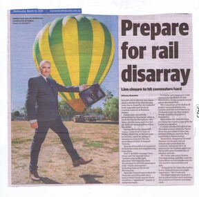
Newspaper Clipping, Diamond Valley Leader, Prepare for rail disarray, 14/03/2018
Roads will be thrown into chaos when a chunk of the Hurstbridge train line is closed for six weeks for track upgrades and the level crossing removal at Rosanna station.News article 1 page, black text and colour image .level crossing removal project, hurstbridge train line closure, rosanna station, hurstbridge rail line -
 Greensborough Historical Society
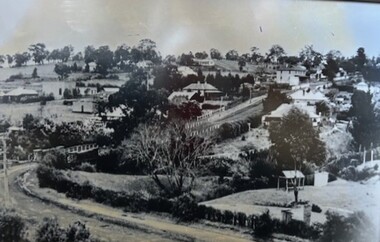
Photograph - Photograph (Framed), Greensborough from Diamond Creek Road
Greensborough from Diamond Creek Road, includes a view of lower Main Street and lower parkFrom the John Mackey collection. this item was displayed at the offices of Ryan, Mackey and Kelly, solicitors, Main Street Greensborough.Timber-framed photograph of view of Greensborough from Diamond Creek Road, black and white.greensborough, john mackey, blue stone bridge, marble hall -
 Camberwell Historical Society
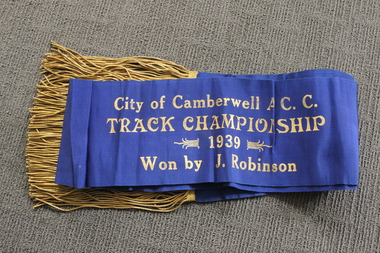
Ceremonial object - Sash, City of Camberwell A.C.C. Track Championship cycling sash, 1939
Champion's sash from 1939 awarded to competitive cyclist Jack Stanley Robinson. Jack Stanley Robsinson lived in Canterbury for most of his youth and was a member of the City of Camberwell Amateur Cycling Club in the late 1930s. Jack appears in the press (NLA Trove) as a member of the Malvern cycling team in a March 1934 trial competition of “boys”, and then with increasing frequency in amateur competitions throughout 1935 to 1938. In October 1938 he appears in the Camberwell team. The last entry so far found is in December 1939, still with the Camberwell team. Blue sash with gold tassels 'City of Camberwell A.C.C. Track Championship 1939 Won by J. Robinson'cycling, sport -
 Ringwood and District Historical Society
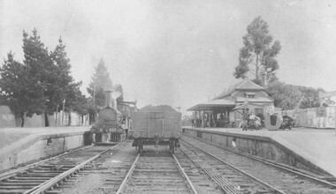
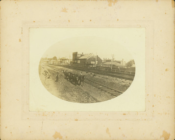
Photograph, Ringwood Railway Station circa 1908
Black and white photograph {2 copies - 1 large, 1 smaller}Image shows steam train at platform with goods carriage on middle track -
 Whitehorse Historical Society Inc.
Pamphlet, Eastern freeway extension, 1/02/2000 12:00:00 AM
Eastern Freeway extension Between Springvale Road and Ringwood: flora and fauna assessment.Eastern Freeway extension Between Springvale Road and Ringwood: flora and fauna assessment. Supplement no 13 : mapping of trees and native vegetation within the Deep Creek Road realignment [by] Botanicus Australia Pty Ltd for VicRoads.Eastern Freeway extension Between Springvale Road and Ringwood: flora and fauna assessment. eastern freeway extension, native plants, wild life, vicroads, deep creek road, mitcham -
 City of Kingston
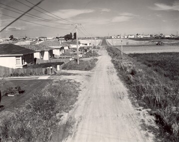
Photograph - Black and white, c. 1960
This image depicts a scene of East Bentleigh in 1960, viewed along Thomasina Street as it crosses Gladwyn Street towards East Boundary Road in the distance. The gardens and new homes are well-tended, but the street surfacing is unsealed.Developing urban area now located within the City of Glen Eira, formally City of Moorabbin. This image illustrates the mid century urban sprawl of new suburbs and the subdivision of market gardens within the municipality and the changing demographic of the district as new houses are constructed and infrastructure established. Black and white photograph of unsealed road in new development in the area of Moorabbin, new houses appear on the lefthand side with paddocks on right side of image with installation of electric poles. Sealed road in the distance. Thomasina Street, as it crosses Gladwyn Street, East Bentleigh towards East Boundary Road. Handwritten in blue ink: 60 - 373 D Handwritten in red ink: 80% Handwritten in black ink: Ch. 6bentleigh, east bentleigh, market garden, housing, suburbs, infrastructure, moorabbin -
 Hume City Civic Collection
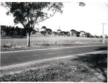
Photograph, c1960s
The photograph overlooks former railway land along Vineyard Road which is now a commercial and light industrial estate. It was taken before curbing and footpaths were laid and Vineyard Road was narrow strip of asphalt with the sides of the road unmade.A black and white photograph of Vineyard Road with the Sunbury Railway line visible across the middle distance and the former Sunbury Asylum site in the background.vineyard road, sunbury asylum, sunbury railway line, george evans collection -
 Phillip Island and District Historical Society Inc.
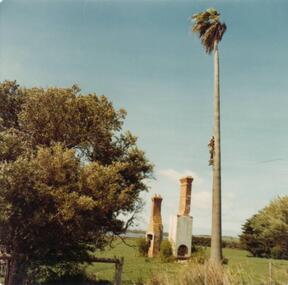
Photograph, 1978/79
Photograph of two chimneys of George Dorward's home on the hill of Newhaven-Rhyll Road. A very tall standing Palm tree, two bushes part of a fence and in background glimpse of Westernport Bay.Remains of the home of George Dorward on the hill on Newhaven-Rhyll Road.local history, photographs, historic, buildings - historical, coloured photograph, john cook, phillip island, george dorward -
Whitehorse Historical Society Inc.
Article, 5 Longland Road, Heatherdale, 1984
Auction Notices of 100 year old Home,Auction Notices of 100 year old Home, 5 Longland Road, Heatherdale, on 10th March 1984.Auction Notices of 100 year old Home, longland road, heatherdale, no. 5 -
 Melbourne Tram Museum
Document - Personal Papers, Melbourne & Metropolitan Tramways Board (MMTB), "Agreement between MMTB and the Commonwealth of Australia, c1940
Set of personal papers - typed carbon copies - copy of "Agreement between MMTB and the Commonwealth of Australia for the construction of tramways to serve the Munition Factories at Footscray and Maribyrnong" dated 22/7/1941 and 21/6/1944 to extend tramways. Covers maintenance, construction costs, finances, property issues and provides details in a schedule. .1 - agreement dated 22/7/1941 - Gordon St extensive, Raleigh's Road and West Road to Williamson Road and Raleigh's road to Park Road. .2 - dated 21/6/1944 - extension of Keilor Road to Essendon Airport. .3 - undated - agreement re double track Maribyrnong Road, Gordon St, West Road, Essendon Depot works, Maribyrnong River Images and record revised 20/5/2019.trams, tramways, mmtb, tramways, commonwealth government, agreements, munitions factory, maribyrnong, footscray -
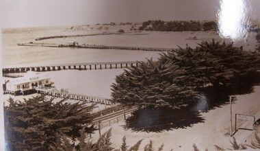 Glenelg Shire Council Cultural Collection
Postcard - Postcard - The Harbour, Portland, n.d
Black and white photographic image of a harbour with two long piers running into it and a shorter jetty with a building on it and circular jetty protruding from it. In the foreground are trees, a dirt road with an RACV sign bridging it to the foreground right and a railway track visible between the trees.Front: THE ROSE SERIES P. 10771/ COPYRIGHT (typed, lower left) THE HARBOUR, PORTLAND (typed, lower centre) -
 Whitehorse Historical Society Inc.
Photograph, Tally Ho Office Park, 1995
Aerial view of Tally Ho Office Park on corner of Springvale Road & Burwood Highway, East Burwood. Site partly developed. Shows East Burwood Reserve (part) and Bill Sewart Athletics Track. Photo taken facing Burwood Highway.lend lease development pty ltd, tally ho office park, springvale road burwood east, burwood highway burwood east, bill sewart athletic track -
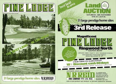 Ringwood and District Historical Society
Flyer, Land Auction Sale Brochure, Pine Lodge, Ringwood North, Victoria - 3rd Release 1978
Refer also to Reg. No. 5171 for Pine Lodge Land Auction previous release, 1977.Green tri-fold advertisement for auction of home sites, with map of subdivision, photographs, and summary of local features and services for Pine Lodge, Kalinda Road, Ringwood North - 3rd release - Auction date, Saturday, 18th November, 1978, at 2:30pm.Subdivision plan includes Mundara Drive, Bidston Court, Parkgate Drive, Frodsham Road, and Bebington Close. (Agent) N.R. Reid & Co. Pty. Ltd., 10A Hewish Road, Croydon (Phone) 725 0999, 450 Little Collins Street, Melbourne (Phone) 67 1746, and 207 Stud Road, Wantirna South (Phone) 221 2222. -
Whitehorse Historical Society Inc.
Document, Electing members of the District Road Board, 1862
Copy from Ivan Southall''s 'A Tale of Box Hill', public meeting for the election of members of the Nunawading District Road Board, for fixing the rate for the current year and appointing auditors.Copy from Ivan Southall''s 'A Tale of Box Hill', public meeting for the election of members of the Nunawading District Road Board, for fixing the rate for the current year and appointing auditors. Extract from Road Board minute book, 10 Sept 1862.Copy from Ivan Southall''s 'A Tale of Box Hill', public meeting for the election of members of the Nunawading District Road Board, for fixing the rate for the current year and appointing auditors.local government, nunawading district roads board -
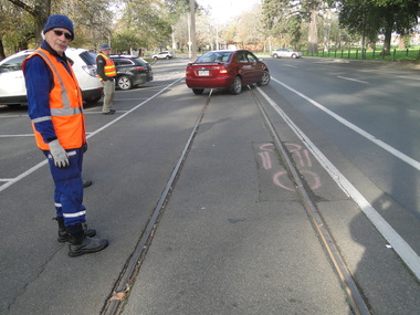
 Ballarat Tramway Museum
Slide - 35mm slide/s, Wal Jack, 4/11/1961 12:00:00 AM
Photo of Ballarat No. 41, derailed in Barkly St. Ballarat near main road on 4-11-1961. Image is going red. Tram fitted with dash canopy lights, small white stripe, large triangles. Penfold Sherry ad on roof. Numerous markings on road surface of previous? derailments. Note advertisement hoardings in background of photo, one featuring an ad for Penfolds. Tram has a destination of 'Mt. Pleasant.''SEC Ballarat No. 41 derailed in Barkly St. near Main Road, 4-11-61 1.40pm' in blue ink.tramways, trams, barkly st., derailments, accidents, mt. pleasant, tram 41 -
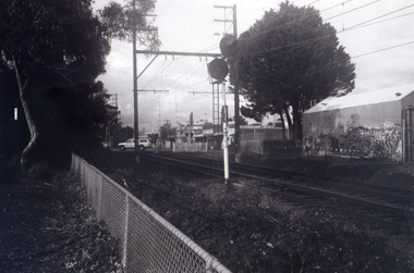 Whitehorse Historical Society Inc.
Photograph, Railway Station from Car Park, 1/06/2009
One of a collection of photographs taken of the Nunawading Railway Station prior to the lowering of the railway line and building of the new railway station on the western side of Springvale Road so that the Springvale Road Rail Crossing can be eliminated.Black & white photograph of the precinct surrounding the Nunawading Station and the Springvale Road Railway crossing. This photograph is of the station taken from the car park on west side of Springvale Road, north of railway line behind Recreation Centre. See NP 3545 to NP3567 for the complete set of photographsnunawading railway station, springvale road nunawading, redevelopment of railway line/springvale road, nunawading recreation centre -
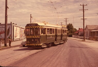
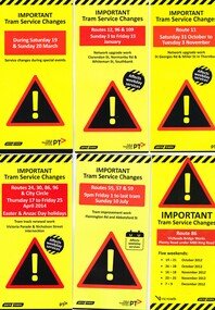 Melbourne Tram Museum
Pamphlet, Yarra Trams, "Important Tram Service Changes", 2012 to 2016
Set of 24 pamphlets, DL size when folded, Full colour, titled "Important Tram Service Changes", giving details of interruptions to the tram system due to Roadworks or events. Have been number .1 to .3 and .5 to .26. Have the logos of Yarra Trams, VicRoads, PTV, .1 - Grand Prix 2016 .2 - Roadworks - Clarendon St, Normandy Road and Whiteman St Southbank, track reconstruction of Southbank or Port junction accessible tram stops, 3/1/16 to 15/1/16 - put in siding for the Restaurant Tram .3 - Route 11 - reconstruction of junction into Preston Workshops - Oct. 2015 .5 - Victoria Parade and Nicholson St intersection reconstruction - April 2014 .6 - Reconstruction of junction - Abbotsford St and Flemington Road - July 2016 .7 - Route 86, VicRoads bridge works - Plenty Road - Oct. to Dec. 2012 .8 - Route 70, Swan St, Burnley track renewal - June 2012 .9 - as for .7 .10 - Route 70, Riversdale Road, Camberwell track renewal, Nov. 2012 .11 - Chapel and Carlisle Sts, Trackwork - June 2013 .12 - ditto .13 - Route 86 - Gertrude and Smith Streets Collingwood .14 - Route 78 and 79 - track renewal Chapel St Sept. 2013 .15 - Elizabeth St track reconstruction and accessible tram stops - Oct. 2013 - see also Reg Item 859. .16 - Tram track renewal, Mt Alexander Road - Ormond Road and Kent St - Routes 55 and 59 - Feb. 2014 .17 - St Kilda Road, between Southbank Blvd and Park St - Feb. 2014 .18 - Overhead Renewal Camberwell depot - March 2014 .19 - Gilbert Road and Miller St - track and overhead renewal - July 2014 .20 - Tram stop works - Melbourne and Olympic Park - August 2014 .21 - Tram stop works - Melbourne Town Hall - Collins St - August 2014 .22 - Matthews Ave, Airport West, route 59 - September 2014 .23 - Tram stop works, Flinders St - Sept. 2014 .24 - Tram stop works - Bourke and Swanston St - Oct. 2014 .25 - Tram stop works - Flinders Jan. 2015 .26 - Elizabeth St works - May and July 2013trams, tramways, grand prix, trackwork, overhead, southbank, tram stops, route 11, victoria parade, nicholson st, preston workshops, abbotsford st, flemington rd, route 86, chapel st, carlisle st, gertrude st, smith st, riversdale rd, swan st, route 70, route 55, route 59, mount alexander rd, st kilda rd, camberwell depot, gilbert rd, miller st, collins st, route 59, matthews ave, flinders st, port junction -
 Bendigo Historical Society Inc.
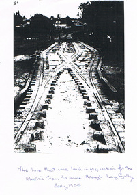
Photograph - LONG GULLY HISTORY GROUP COLLECTION: TRAM TRACKS IN LONG GULLY
BHS CollectionBlack and white photocopy of the incomplete tram track which was laid in preparation for the Electric Tram to come through Long Gully. Photo shows a single track in the foreground and then branches into two tracks. Part of the photo is very dark. In the foreground the brickwork between the tracks is incomplete. Written under the picture is: The line that was laid in preparation for the Electric Tram to come through Long Gully. Early 1900.bendigo, history, long gully history group, the long gully history group - tram tracks in long gully, electric tram -
 Orbost & District Historical Society
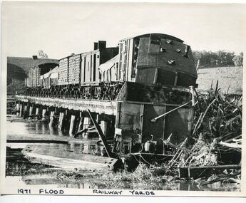
black and white photograph, February 1971
The 1971 flood was the the worst flood on record. At Jarrahmond it was at least 11 metres and up to one and a half kilometres wide on the flats causing enormous damage to the flood plain. Records say that "The brown floodwater stain in Bass Strait could be seen from passing airliners." Considerable damage was done to railway infrastructure, roads and farms. More information from the APRIL, 2008 newsletter by John Phillips. (see orbosthistory.com.au) The railway line was destroyed and was not expected to be opened for a fortnight. Orbost was cut off by 50 square miles of Snowy River floodwater. This train was being shunted across the viaduct when waters smashed through washing away several trucks sending the crew running for their lives.This is pictorial evidence of a significant local event. It is connected to the history of the railway in East Gippsland.A large black / white photograph of flooded railway yards with a train engine stranded on a small section of track surrounded by water and debris.on front - "1971 Flood, Railway Yards"floods-1971-orbost orbost-railway natural-disasters-orbost -
 Orbost & District Historical Society
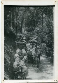
black and white photograph, late 19th - early 20th century
This is a photograph of bullock teams on the Cann Road. out of Cann River, East Gippsland.This is a pictorial record of transport in the mid 18th - early 19th century. Bullock teams could travel in country inaccessible to larger horse - drawn carts or wagon.A black / white photograph of two bullock teams travelling side by side along a bush road.transport-bullocks cann-river -
 Whitehorse Historical Society Inc.
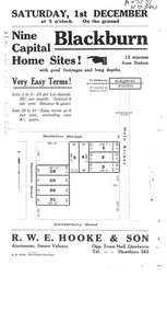
Document, Auction Notice
Auction notice for 9 home sitesAuction notice for 9 home sites in Molleton Street, Baldwin Road and Main Street, BlackburnAuction notice for 9 home sitesauction notice for molleton street, baldwin road, blackburn -
Whitehorse Historical Society Inc.
Document, Certificate of Title - Frederick Charles Phillips, 1909, 1934
Certificate of Title.Certificate of Title for Lot 19, Springvale Road, Tunstall and correspondence re outstanding rates on the propertyCertificate of Title.shire of blackburn and mitcham, rates, land titles, phillips, frederick charles, springvale road, nunawading -
Canterbury History Group
Photograph - Old Timber House in Maling Road, Jan Pigot, 1992
Part of a set of 8 coloured photographs taken by Jan Pigot to record the demolition of some buildings in Maling Road to make way for new shops and car park.Old timber house on corner of Scott Street and Maling Road 1992. canterbury, maling road, timber house, scott street, shopping centres -
Whitehorse Historical Society Inc.
Article, Blackburn Level Crossing
Blackburn Road level Crossing was closed for 2 weeks.Blackburn Road level Crossing was closed for 2 weeks for the rail line to be lowered under Blackburn Road. More than 1,000 piles will be drilled to reinforce the rail corridor which is due to be completed 2017.Blackburn Road level Crossing was closed for 2 weeks. level crossing removal authority, blackburn road, blackburn railway crossing, blackburn railway station -
 Marysville & District Historical Society
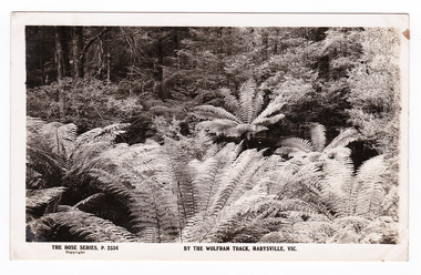
Postcard (item) - Black and white postcard, Rose Stereograph Company, By the Wolfram Track, Marysville, Vic, 1913-1967
A postcard in a series produced by the Rose Stereograph Company in Victoria, Australia as a souvenir of Marysville.A black and white photograph of a part of the forest that the Wolfram Track, which is part of the Wilks Creek Walking Track, runs through. The Wilks Creek Walking Track is in Marysville in Victoria. The Wolfram Track is named after the Wilks Creek Wolfram Mine which opened in around 1894. Wolframite is one of the principle ores of tungsten. The discovery was made in Wolfram Creek by a Mr Robinson who was probably a local of the district. Four creeks eventually proved to carry alluvial deposits of the ore; Wolfram Creek, Opas Creek, Quartz Creek and Main Creek. These creeks run south-east into Deep Creek, a tributary of the O'Shannassy River which, in turn, runs into the Yarra River.POST CARD The "Rose" Series/ De Luxe A Real Photograph/ Produced in Australia Published by the Rose Stereograph Co.,/ Armadale, Victoria.wolfram track, wilks creek walking track, walking track, marysville, victoria, p. 2334, rose series postcard, postcard, souvenir, p. 2332, wolframite, wolfram creek, opas creek, quartz creek, main creek, deep creek, o'shannassy river, yarra river, mining -
Whitehorse Historical Society Inc.
Document, City of Nunawading Heritage Survey Project, 1/10/1994 12:00:00 AM
Database of places recognised in the field survey.Database of places recognised in the field survey. List of buildings, roads etc with indexes by value and by street name.Database of places recognised in the field survey. city of nunawading heritage survey, street name -
 Ringwood and District Historical Society
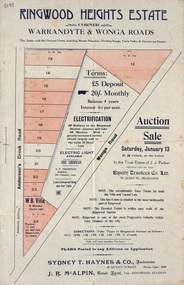
Flyer, Land Auction Sale Advertisement - Ringwood Heights Estate, Ringwood, Victoria - circa 1923
Advertisement for land and weatherboard villa auction sale on Saturday, January 13 (1923?) - Ringwood Heights Estate, corner Warrandyte and Wonga Roads, North Ringwood, with terms of sale, summary of local features and services, and map showing layout of subdivisionSubdivision includes Wonga Road and Anderson's Creek Road (later Warrandyte Road). Agents - Sydney T. Haynes & Co., Auctioneers, 60 Queen Street, Melbourne. Phone Central 3400; J.B. McAlpin, Estate Agent, Opposite Ringwood Station. Auction in the Trust Estate of J.J. Parker, instructed by the Equity Trustees Co. Ltd. 85 Queen Street, Melbourne. -
 Kew Historical Society Inc
Photograph - Regrading the Camberwell Railway Line near Burke Road, E.J. Dower, 1915
One of a series of photographs, taken by Edgar James Dower in the second decade of the twentieth century. Born and raised in Olinda, his family later moved to Surrey Hills. He worked as an adult as a clerk in the city office of the Metropolitan Gas Company, and in his role as a 'collector', he was able to photograph scenes including the construction of tramlines, railways and associated buildings in Kew, Hawthorn, Camberwell and Surrey Hills. Later he established a real estate agency with his brother - the E.J. Dower Real Estate Agency, Dandenong Office.The image is an historically significant record of the development of transport infrastructure which was used to connect Victorians in the first two decades of the twentieth century. This development resulted from increases in population and the consequent extension of Melbourne's suburbs. The photographs, both individually and collectively, richly detail the labour of workers and the tools and machinery used to create and extend Melbourne's public transport network in the years preceding and during World War 1.Digital copy of an original oval mounted photograph depicting workers regrading the Camberwell Railway line following the demolition of the original Camberwell Railway Station. The level crossing gates at Burke Road can be seen in the distance. Named buildings include The Assembly Hall at right.Verso: "1915 / Regrading Camberwell railway line, near Burke Road / Taken by E.J.Dower."theme -- connecting victorians by transport and communications, theme - camberwell railway station, theme - travelling by train -
Melbourne Tram Museum
Pamphlet, Public Transport Victoria (PTV), "Buses replace trams - route 48, 75, 78", Jan 2021
Issued for track renewal and overhead work in Bridge Road between Chapel St and Burwood Road, between 3 January and 16 January 2021. Gives details of the replacement and alternative bus routes. Produced by Yarra Trams and the PTV.Yields information about track work in Bridge Road Richmond early 2021Pamphlet - full colour DL 4 fold.trackwork, tramways, bridge road, route 48, route 75, route 78 -
 Ballarat Tramway Museum
Photograph - Digital image Set of 11, Peter Waugh, 21/07/2015 12:00:00 AM
Track repairs in Wendouree Parade, June 2014. 6022.1 - Roger Gosney standing on track looking at damaged section 6022.2 - Close up of damaged section of track 6022.3 - Work crew including dog in safety vest 6022.4 - Work crew digging up road watched by the dog 6022.5 - Close up digging up road, Alan Snowball using jackhammer, Greg Robinson with spade, Roger Gosney on the far side with spade, and Barry Richardson with spade. 6022.6 - Greg Robinson in trench watched by Alan Roger, and Barry 6022.7 - Same group looking into the trench 6022.8 - Alan on hands and knees beside trench preparing for welding 6022.9 - preparing for welding, with safety screens in place. 6022.11 - Greg Robinson and Roger Gosney resting beside Wendouree Parade. (no. 10) Photo by Peter Waugh, collected for reference purposestrams, tramways, road works, btm, track repairs, wendouree parade