Showing 173758 items
matching street
-
 Sunbury Family History and Heritage Society Inc.
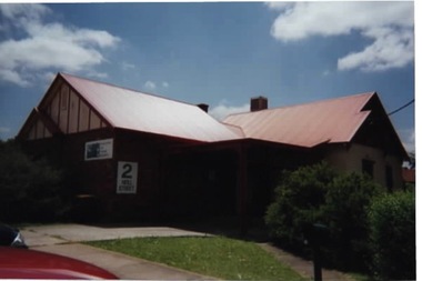
Photograph, Former medical centre, 2001
The house was one of Sunbury's older houses and was on the corner of Horne and Neill Streets. Before it was demolished for larger commercial development, the property was a medical centre and later an employment and training office. A coloured photograph of a weatherboard house with a corrugated iron roof with its street number clearly attached to the front of the house.horne street, neill street -
 Sunbury Family History and Heritage Society Inc.
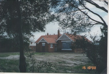
Photograph, Rosa McCall, Former Sunbury State School, 15th October 2000
The photograph was included in an exhibition organised by the former Sunbury & District Heritage Association in March 2001. The red-brick Federation building for Sunbury State School No. 1002 in Macedon Street opened on 2nd May 1912. It replaced an earlier building that was on the same site. It originally had two classrooms and an office but as Sunbury's population began to grow another room was added. The school continued to function in Macedon Street until 1999 when it took occupancy of refurbished rooms at the former Industrial School in the Asylum Grounds at Jascksons Hill. The building in Macedon Street has been incorporated into the Sunbury and Cobar Community Health Centre. The red-brick Federation Style Sunbury building has served the educational needs of the Sunbury Community for 112 years as it is now an Educational facility for people with disabilities.A non-digital coloured photograph go a red-brick federation school building with cream trims around the windows and doors.Two trees are growing in the foreground.sunbury state school no. 1002, macedon street, education, schools -
 Melbourne Tram Museum
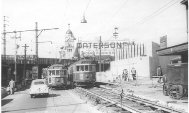
Photograph - Black and White - Swan Street track lowering, John Alfred, 1957
Photo shows - works in Swan Street Richmond to lower the tram tracks under the Railway bridge which were later replaced by an open web girder truss bridge. The track on the left has been completed while on the right, the original road surface can be seen as well as the temporary track. Shows the abutment for a new railway bridge on the right, for the six tracks to South Yarra. Tram W2 330 (left, Camberwell Depot, route 76) and 339 (City, route 77) are passing each other. In the background is a large advertisement for Pattersons home furnishings. Photo dated 1957.Yields information about alterations to tram services during road reconstruction project.Photograph - Black and White - Swan Street track lowering Has details handwritten on rear, date stamp and John Alfred Stamp. tramways, tramcars, swan street, richmond, route 77, railways, bridges, tram 330, tram 339 -
 Federation University Historical Collection
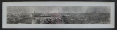
Photograph - Photograph - Black and White, Ballarat, c1858, c1858
Four photographs framed together to produce a panorama. The four photographs were taken from the slope of the Ballarat School of Mines where the Wesley Church now stands. When joined they gave a panoramic view of one of the world’s richest alluvial goldfields. The town you see had over 50,000 people. Bridge Street on the left is well established. The crude pans and cradles of the early “diggers’ were already giving way to steam power and the deep shafts of the “miners”. Money and machinery were needed to get to the deeper leads, and the smoke stacks of the great company mines can be seen across the photo. The waterloo mines was one of the first deep shafts and was sunk at the foot of the Dana Street hill. Its tailings are seen in the second photo from left. ballarat, ballarat gas works, mount warrenheip, shingle roof, mullock heap, mining -
 Uniting Church Archives - Synod of Victoria
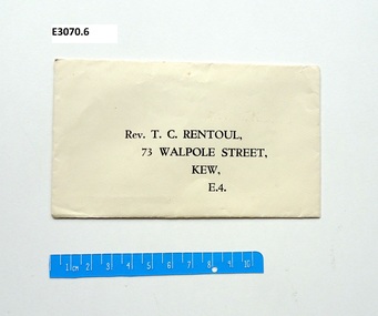
Document - Envelope, Rev T C Rentoul
Rev Thomas Craik Rentoul was the General Superintendent and Director of the Methodist Home Missions whose training school was at "Ortira" 73 Walpole Street, Kew.Small envelope with the name and address printed on it. Rev. T. C. Rentoul, 73 Walpole Street, Kew, E. 4.rev t. c. rentoul, methodist home mission -
 Melbourne Tram Museum
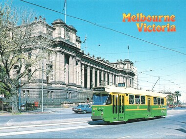
Postcard - Spring Street, Parliament House Z3 224, Colour Tech Productions Pty Ltd, mid 1980s
Postcard Spring Street, Parliament House Z3 224 - route 88. Tram entered service September 1983. In The Met livery with the Met logo. Yields information about Z3 class trams and Parliament house mid 1980s.Postcard colour - Spring Street, Parliament House Z3 224 - Colour Tech Productions. Card Number CTM 115Ktrams, tramways, z3 class tram, spring street, route 88, parliament house -
 Kyneton Museum
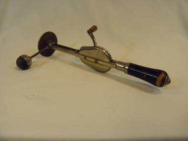
Massage Equipment, c 1900 - 1910
Item found at Enid Walls estateHand held wooden-handled metal object. Object movement/use is similar to an egg beater. Has a rubber ball bevelled into metal base which is attached onto the side with a slender metal arm.Stamp on object proper left "PAT.B 99365". Object proper right middle metal part has hand written inscription of a name which appears to be "Harvey". Top metal disk has the inscription "VEEDEE"/The Veedee Co./96 Southwark Street/London.Smedical instruments, personal massager/vibrators, enid wall -
 Port Melbourne Historical & Preservation Society
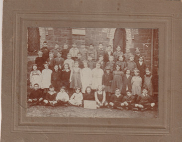
Photograph - Students Graham Street Primary School c.1921/22, c.1921/22
Norma PEET (ELDEN) 4th from right bottom standing row. Classes were held in the Methodist Church, Graham Street, while Graham Street Primary School was being renovated.Sepia photograph mounted on brown card. Three rows of Graham Street Primary School, Port Melbourne students standing with the front row seated in front of Methodist Church.Norma Elden Peet, Graham St School held in Methodist Church while school being renovated. 4th from Right Bottom Row. 1921-2. norma elden, norma peet, education - primary schools, graham street primary school, religion - methodist church graham street -
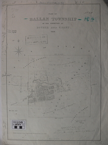 Ballan Shire Historical Society
Map - Map. Ballan Township, Plan of Ballan Township in the Counties of Bourke and Grant
The map is an early one of the township of Ballan showing street names and land owners.The map is significant in that it lists the owners of the house blocks within the township.A map showing the township and surrounding area of Ballan in 1856. Town streets are named as are the owners of the subdivided blocks of land. The map is a lithocopy and there is a scale in chains."D D Fraser" is written across the top of the map and "1856" is written in the near top right corner. There are other additions to the map but they are very difficult to decipher accurately or completely.ballan, ballan township map, ballan1856 -
 City of Kingston
Pamphlet - Colour, Stillwell and Co, Cheltenham Charman Estate Realising Auction, 1921
Sales plan for land in the suburb of Cheltenham, along Charman Road and Weatherall Street.The developing urban area of Cheltenham within the City of Kingston. This land sale pamphlet illustrates the subdivision of land within the municipality and the changing demographic of the district as new houses are constructed.Colour pamphlet advertising realising auction of the Charman Estate, Cheltenham. Incorporates a map of the estate, showing subdivisions along Charman Road and Weatherall Street.land sales, cheltenham, estate -
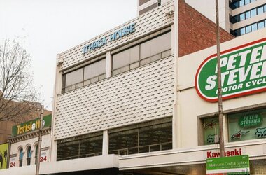 Ithacan Historical Society
Photograph, Ithaca House, 2016
Ithaca House located at 329 Elizabeth Street Melbourne has been the site of the clubrooms of the Ithacan Philanthropic Society since 1958. Over the decades the club rooms have served as a meeting place and a venue for many social, cultural and fundraising activities. Prior to the building of Ithaca House, the clubrooms been located at Michael's Building, corner Lonsdale and Elizabeth Streets since 1917.In 1956, the Ithacans of Melbourne purchased a site, formerly two shops, at 329-335 Elizabeth Street for £35,000, with a view to building their own club rooms. A three storey building, a stone's throw from the old Michael's clubrooms, was finally erected in 1958 at a cost of £25,000. This was achieved by capital raising from the membership in the form of non-redeemable £10 and £50 debentures (1957-58). Plans were drawn up by the Australian born and newly qualified Ithacan architect, Nicholas Sofarnos (Sofianos). The then President Eustathios (Stathis) Vlassopoulos was key driver of the project. A colour photograph of the front upper stories of Ithaca House -
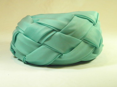 Brighton Historical Society
Headwear - Hat, c.1960s
This hat belonged to Mrs Moyra Rasmussen, who lived at 389 St Kilda Street, Brighton for over 50 years with her husband Rae Rasmussen, a bank manager with the State Bank of Victoria. The Mooney sisters, Nell and Ida, were situated beside the Regent Theatre in Collins Street, Melbourne and were well respected milliners and dressmakers. The hat's style is typical of the 1960s. Woven turquoise silk taffeta turban style ladies hat with half bow, circa 1960s. White mesh interior with teal grosgrain binding, thin black elastic band.Label, woven black on white: MISSES MOONEY / OF MELBOURNEhat, turban, rae rasmussen, brighton, misses mooney, millinery, melbourne designers, moyra rasmussen -
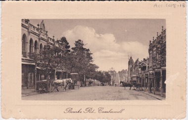 Camberwell Historical Society
Postcard - Photo postcard, Postcard of Bourke Road, Camberwell, Unknown date but postcard probably dated circa 1900 - definitely pre 1913 because in that year gas lamps were removed from main roads, intersections, also street trees in Burke Road. Also no cars are visible on the street, only horses and carriages. In March 1894 the first streets in the central city of Melbourne were lit with electricity
Undated photograph on postcard depicting horses and carts with gas lamp in the distance on Bourke Road, Camberwell. Front of postcard: 'Bourke Road, Camberwell' Back of postcard: 'Post Card' 'This side for correspondence' 'This side for address' 'Stamp here' 'Printed in Germany.' Handwritten notes '22649 $20'camberwell, bourke road -
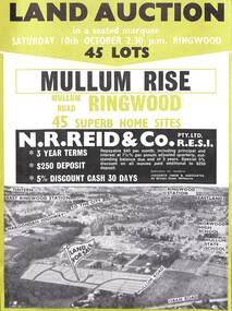 Ringwood and District Historical Society
Flyer, Land Auction Advertisement, Mullum Rise, Ringwood - 1970
Double sided leaflet with aerial view of part of Ringwood showing subdivision site, terms of sale, layout of streets and allotments, and summary of local features and services.Land auction, Saturday, 10th October (1970). 45 home sites. Subdivision includes Mullum Mullum Road, Hugh Street, Rollington Drive, Cassandra Court, and Jeffrey Drive. Surveyors - R.G. Lee Pty. Ltd., 6 Davis Street, Richmond. Agents - N.R. Reid & Co., 173 Coleman Parade, Glen Waverley, (Telephone) 560 0355 A.H. 560 0361 and Safeway Centre, Boronia Road, Boronia, (Telephone) 762 1022 A.G. 795 2887, also at East Malvern and Mount Waverley. -
 Bacchus Marsh & District Historical Society
Map, Atkins and Clarke Land Sale situate at Bacchus Marsh 1856 Copy 2
This plan of land allotments for sale indicates the property once owned by the Bacchus family in and around the township area of Bacchus Marsh. The Bacchus family sold their property in Bacchus Marsh to John Atkins and Robert Nalder Clarke in March 1851. Atkins and Clarke kept the property for a number of years until April 1856 when these allotments were put up for sale.This plan is almost identical to another copy held by the Bacchus Marsh and District Historical Society, VC Record 707, BMDHS collection). This plan, VC Record 452 Copy 2, contains a less detail than than VC Record 707 Copy 1. For example the selling agents and the surveyor who created the plan are not indicated on this copy of the plan. This copy of the plan does indicate the name Crook Street on the map. As the Crook family were the buyers of the Manor House property and surrounding land from Atkins and Clarke in 1856 it suggests that this copy is a later one of the earlier version. It is unlikely that the Crook family would have had the adjacent street named after them prior to purchasing the house and property. This is a very early land sales plan for the township of Bacchus Marsh and it therefore provides some clues as to how the early urban development of the township took place. Upon seeing the map in 1911 Bacchus Marsh Express newspaper editor Christopher Crisp wrote "The sale appears to have created the present township, which had a nucleus in earlier times further east", Express, 30 September, 1911, page 3. A single page paper map showing a portions of land available for sale in Bacchus Marsh in 1856. The subdivided land shown was owned by John Atkins and Robert Nalder Clarke, but previously owned by the Bacchus Family and was in and around their Manor House (Mansion) property in Bacchus Marsh.There are 5 portions of land further divided into numerous small portions. The land for sale is bounded by the present day streets of Main Street, Young Street, McFarland Street, Morton Streets, Crook Street, and part of the eastern section extends to the Lerderderg River. Scale: 4 chains to 1 inch. The map is pasted into a bound volume containing 76 maps or plans in total. High resolution digital image stored on BMDHS computer network. Plan of the first portion of land. The property of Messers Atkins and Clarke situate at Bacchus Marsh.land sales, land sales bacchus marsh, manor house bacchus marsh, crook family bacchus marsh -
 Whitehorse Historical Society Inc.
Document, Villa Residence, 11/12/1937 12:00:00 AM
Auction brochure for 'beautiful modern brick villa residence', with 4 1/4 acres of land, Mitcham Road Mitcham, Saturday December 11 1937.Auction brochure for 'beautiful modern brick villa residence', with 4 1/4 acres of land, Mitcham Road Mitcham, Saturday December 11 1937, under instructions from the executors of the estate of the late E. E. Walker. Frontages to Mitcham Road, Delhi Street and Agra Street. Auctioneers: Baillieu Allard in conjunction with Drake & Co. Original copy framed, located in Map Drawer.Auction brochure for 'beautiful modern brick villa residence', with 4 1/4 acres of land, Mitcham Road Mitcham, Saturday December 11 1937.walker, edgar edwardes, walker estate, mitcham road, mitcham, delhi street mitcham, agra street, mitcham, drake & co., baillieu allard pty ltd -
Tatura Irrigation & Wartime Camps Museum
Photograph - copy, D. Clark, Royal Visit 1954, 1989 copy
Copy of photograph of crowd of people who waited at Park Street, Tatura, crossing, to farewell the Royal couple on their way to Echuca. Queen Elizabeth and Duke of Edinburgh passed through Tatura on Friday 5 March 1954.Black and white copy of photograph of many people waiting at Park Street, Tatura, crossing for Royal train, on back: Royal Visit 1954royal visit -
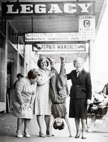 Melbourne Legacy
Photograph, Widows, 1960s
Photo of three Legacy Widows with a Junior Legatee taken on the footpath outside Legacy House, Swanston Street, Melbourne. Possibly in the 1960’s. L to R: unknown, Lorraine Traves, unknown child, Myrtle Roberts.A lovely shot of Legacy dependants, showing their enjoyment of life despite the challenges of being widowed. Also of interest are the neighbouring business and the traffic restrictions.Black and white photo of widows and a child taken on the footpath outside Legacy House in Swanston Street, Melbourne. legacy promotion, widows -
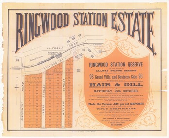 Ringwood and District Historical Society
Poster - Auction, Ringwood Station Estate, Ringwood, Victoria - circa 1925
Colour photocopy of poster sub-titled Ringwood Station Reserve & Railway Station Reserve. Auction of 93 sites on Saturday 27th October (no year, likely 1925). Subdivision includes Station Street, Government Road (Wantirna Road), James Street, William Street. Auctioneers - Hair & Gill, 16 Collins Street West and Glenferrie. Solicitor - Seymour Fergie, Elizabeth Street. Surveyors - Fowler & Gatward, 12 Collins Street West. -
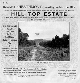 Ringwood and District Historical Society
Pamphlet, Atlas Press Pty. Ltd., Melbourne, Land Sale Brochure, Hill Top Estate, Heathmont, Vic. - circa 1925
Twelve page land sale brochure promoting Heathmont and Ringwood area including photographs, subdivision features and local facilities. Subdivision plan includes Heathmont Road, Balfour Avenue, Edith Street, Edna Street, and Great Ryrie Street. -
Glen Eira Historical Society
Article - Villiers Street, 15, Elsternwick
Unattributed advertising article dated 28/09/01 by Carmichael and Weber for forthcoming auction of 15 Villiers Street, Elsternwick.elsternwick, villiers street, st. georges road, architectural styles, carmichael and weber, waterton danielle, carmichael iain -
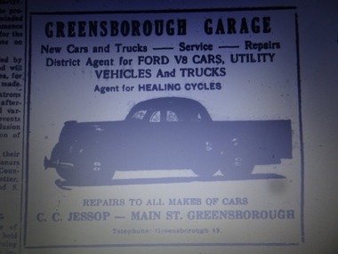 Greensborough Historical Society
Advertisement - Digital Image, Greensborough Garage 1940s, 1940s
Advertisement from a newspaper for Greensborough Garage of Main Street Greensborough 1940s. Proprietor: C.C. Jessop (known as Snowy Jessop).Part of a collection of miscellaneous advertisements for businesses in Greensborough and surrounding areas.Digital copy of newspaper advertisement.main street greensborough, greensborough garage, snowy jessop, clarrie jessop, jessop family -
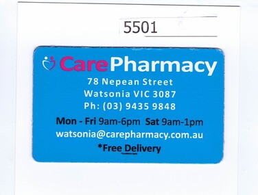 Greensborough Historical Society
Refrigerator magnet, Care Pharmacy, 2000c
Name changed to Watsonia Compounding Pharmacy, 9/78 Nepean Street Watsonia 3087 (Diamond Village Shopping Centre)Refrigerator magnet, red, white and black print on blue"Care Pharmacy", address, phone number, opening hours and emailpharmacies -
 Greensborough Historical Society
Prescription Folder, Diamond Village Discount Chemist, 2018_
Opened in Diamond Village in January 2018, the Diamond Valley Discount Chemist is situated at 6/78 Nepean Street GreensboroughFolder, printed in red and dark blue on white. Used to hold prescriptionspharmacies, nepean street greensborough -
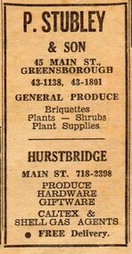 Greensborough Historical Society
Advertisement - Digital image, Diamond Valley News, P. Stubley & Son, Greensborough 1967, 28/11/1967
Advertisement in the local paper for P. Stubley & Son, general produce, with two stores in Main Street Greensborough and Hurstbridge, 1967.Part of a collection of historic advertisements from local newspapers, showing local businesses from the mid 20th century.Digital copy of newspaper advertisement.main street greensborough, purcell stubley, stubley group greensborough -
 Sunbury Family History and Heritage Society Inc.
Photograph, C
The people were photographed standing on the Macedon Street bridge which spans the Jacksons Creek at the east end of the town of Sunbury.A sepia photograph in post card format of five people with a dog standing in front of a picket fence on a road bridge.SUNBURY BRIDGEmacedon street bridge, jacksons creek, sunbury -
 Ringwood and District Historical Society
Document, Plan of Subdivision - Part of Crown Portion 5, Parish of Ringwood, County of Bourke - (Undated)
Map showing layout of 4 numbered allotments coloured red and land coloured blue appropriated or set aside for drainage and sewerage puposes.Map includes Nelson Street and Ringwood Street, Ringwood, Vic. -
Port Melbourne Historical & Preservation Society
Photograph - Wedding procession Maree MENZEL & Marcus DAVIDSON, Station Street to Yacht Club, Pat Grainger, 1989
Maree and Marcus of 63 Station Street married after several years of living together. As she is a fashion designer, she designed and made all costumes; as he is a musician, some of his friends played jazz and rock for the procession to the Port Melbourne Yacht Club for the ceremony. Only three neighbours (including photographer) were invited to accompany the procession. The wedding must have been one of the last functions in the clubhouse before it burned.From a group of photographs of the 1989 wedding procession of Maree MENZEL and Marcus DAVIDSON, from the railway reserve near 63 Station Street to the Port Melbourne Yacht Club: procession in Donaldson Streetcelebrations fetes and exhibitions, built environment, maree menzel, marcus davidson, station street, port melbourne yacht club -
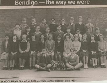 Bendigo Historical Society Inc.
Newspaper - JENNY FOLEY COLLECTION: SCHOOL DAYS
Violet Street Primary School No. 877, was established in 1866 as the German Common School. It was designed by William Vahland who laid the foundation stone in February of that year. It was built by subscriptions from the local German community. In 1872 it combined with the McKenzie Street German School on the Violet Street site.Bendigo Advertiser ''The way we were'' from Monday, December 29, 2003. School days: grade 6 Violet Street State School students; circa 1950. The clip is in a folder.newspaper, bendigo advertiser, the way we were -
Glenelg Shire Council Cultural Collection
Photograph - Photograph - Bridgewater Construction, n.d
Port of Portland Authority ArchivesFront: Back- Margin ruled in pencil, diagonal in pencil. 'C' 4x2 1/4 - Pencil 'Bridgewater road bridge 29/3/57 looking s.s.w'- written in blue biro. 'Otway Street Bridge - Pencilport of portland archives, otway street bridge, bridgewater road bridge construction