Showing 2267 items matching "rail"
-
 Bendigo Historical Society Inc.
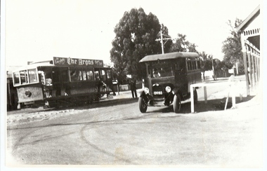
Photograph - BASIL MILLER COLLECTION: TRAM AND BUS
Black and white photograph of single bogie tram, advertising 'The Argus', above side windows. Old 'bus-like' vehicle to right nest to white post and rail fence. Man with a white flag standing between both vehicles. Reverse: The word 'Basil' printed in black biro. Stamped in grey/black ink 'Dennis O'Hoy 13 Hill Street Bendigo 3550.person, individual, basil miller -
 Bendigo Historical Society Inc.
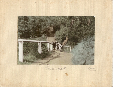
Photograph - LOVER'S WALK, COWES
coloured photo: family group ? 3 adult females in cloche hats and overcoats, two small females on scenic walk. Path through bush and trees with white post and rail fence. On front board, handwritten ' Lovers Walk, Cowes' Won by Mr. L. Batchelder ( Bendigo Photographer's family ? ) ' Gents Rope Quoits/Bay View Cowes, Feb. 1933 'A.J. Murray, Ciommercial Photographer, Photo Shop, Cosesplace -
 Bendigo Historical Society Inc.
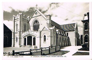
Postcard - ST. ANDREW'S PRESBYTERIAN CHURCH, BENDIGO VIC
black and white photo: St. Andrew's Presbyterian Church, Bendigo, In centre of photo, St. Andrew's Church, conceted forecourt, in centre of photo, wooden slat fence with top rail. On bottom of photo: 'St. Andrew's Presbyterian Church, Bendigo, Vic. The Rose Series P 3199.' On back of photo: 'Post Card, The Rose Series Deluxe. A real photograph, produced in Australia'Rose Seriesbuildings, church, st. andrew's presbyterian church, st. andrew's presbyterian church, bendigo, religion -
 Port Melbourne Historical & Preservation Society
Photograph - Beacon Cove, 2006
Photographic images of properties in Port Melbourne. Image may have been taken by a PMHPS member or scanned from a past resident or taken for real estate sale purposes. Beacon Cove; two images looking West towards the Bay showing the light rail line, bike path and waterfront developments in distance. One image includes tram. (January 2006)built environment - domestic, transport - tramways, beacon cove, light rail, tram -
 Whitehorse Historical Society Inc.
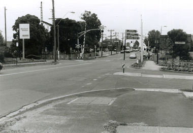
Photograph, Mitcham & Brunswick Roads, 2000
Produced as one of a series of 24 prints commissioned by Nunawading & District Historical Society -|Theme: Intersections of Mitcham and Nunawading 2000/2001.|See also Series by P. Simmenauer on the same theme.Black and white photograph - print and negative of Corner of Mitcham Road and Brunswick Road, Mitcham, looking North towards Railway Crossing. From left-right: Rail Station sign - 'Mitcham/Station/Connex'. On near side corner of Brunswick Road signage for: Mitcham Angling Club; Mitcham Community Centre; Mitcham Senior Citizens Club; Street sign: Brunswick Road.mitcham railway station, connex, mitcham angling club, angler's club, mitcham community house, mitcham senior citizens club, brunswick road, mitcham, mitcham road -
 Ballarat Tramway Museum
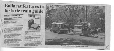
Newspaper, The Courier Ballarat, "Ballarat features in historic train guide", 7/06/1997 12:00:00 AM
Newspaper cutting from The Courier, Ballarat, Saturday 7/6/1997 in the Book Review section of the "Guide to Heritage Railways and Museums" published by the ARHS (NSW), RRP $16.95. Includes a photo of the horse tram and tram No. 14 at the crossing loop, which is featured in the guide. Gives details of the coverage of the district rail based museums, publication details and general details of the book.On left hand edge of the cutting, "Sat. 7/6/1997" in blue ink. Also a blue ink cross in the bottom right hand corner.trams, tramways, btm, horse trams, tour guide, rail museum guide -
 Ballarat Tramway Museum
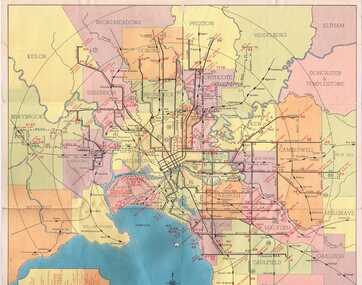
Map, Compiled by MMTB, "Map and timetable of Melbourne Tram and Bus Services" - May 1956, May. 1956
Fold out map (10 sections), coloured of Melbourne's Tram and Bus routes, route numbers, rail lines, municipalities boundaries and location of major places of interest. At base of map - timetable of all night trams and bus services. On rear index to routes, 1st and last services, time of Sunday am services, Latrobe St. services and photo of Wattle Park.trams, tramways, melbourne, map, tram & bus services, all night services, mmtb -
 Bendigo Historical Society Inc.
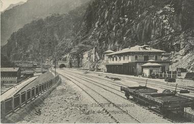
Postcard - ROY AND DORIS KELLY COLLECTION: STAZIONE D'ISELLE E TRASQUERRA (STRADA DEL SEMPIONE), CARTE POSTALE, 1900-1920
Postcard, B&W photo of the railway station serving the villages of Iselle and Trasquerra in the Piedmont region of north west Italy. It was opened in 1906. The rail tracks lead to the entrance of the Simplon Tunnel in the distance. An empty flat tray carriage sits on the tracks (lower right). Part of the the Simplon road (Strada del Sempione) is shown at lower left. This road connects Italy to Switzerland.postcard, photograph, postcard, iselle, trasquerra, italy, station, simplon tunnel. -
 Melbourne Tram Museum
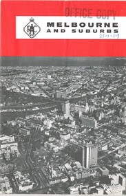
Map, Royal Automobile club of Victoria (RACv), "Melbourne and Suburbs", late 1960's
Map - folded 8 folds or sections, printed in two colours titled "Melbourne and Suburbs", published by the RACV late 1960's, giving a map of Melbourne and its suburbs, shows all tram and rail lines, highways, freeways under construction, has a detailed index and map of the city or CBD area, shows one way streets and churches, clubs etc.On front cover stamped "Office Copy" and hand written date of "28-1-69"trams, tramways, racv, melbourne, map, tramways, timetables -
 Melbourne Tram Museum
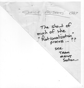
Document - Report, Metropolitan Transit Authority (MTA), "MTA Engineering & Maintenance Change Projects", 1987
Photocopied 140 page document titled "MTA Engineering & Maintenance Change Projects", produced by the MTA, 11/12/1987 setting out the proposal changes to MTA staff, use of contractors, consultation with the unions, consultation with unions, has a table of contents, index. Looks at construction activities, building maintenance and track maintenance, electrical and vehicle maintenance for the rail and tram divisions.trams, tramways, ptc, unions, tramways, railways, mta, workshops -
 Melbourne Tram Museum
Pamphlet, Public Transport Victoria (PTV), "Service Changes - White Night", Feb. 2017
Pamphlet - 2 fold full colour printed cut to hang over a grab rail on a tram advertising Service Changes for the White Night event, 18 Feb. 2017 and providing details of extra tram, bus and train services. Has a map showing the White Night Zone and where services could be found. Has Victorian Government, Yarra Trams and PTV logos.trams, tramways, night trams, public transport, ptv, events, melbourne -
 Melbourne Tram Museum
Document - Instruction, Metropolitan Transit Authority (MTA), "A New Fare System for Melbourne Staff Training Instructions", Nov. 1983
Instruction - 18 A4 photocopied sheets with the Metropolitan Transit Authority of Victoria logo and head titled "A New Fare System for Melbourne Staff Training Instructions" detailing the introduction of the Neighbourhood Ticketing System from 13/11/1983. Details the Neighbourhoods, 10, map of the rail lines, availability, weekly and other cars, use, conditions, refunds, accounting procedures and other changes.trams, tramways, neighbourhood tickets, the met, mta, tickets -
 Melbourne Tram Museum
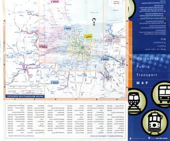
Map, Department of Infrastructure (DOI), "Melbourne's Public Transport Map", Jul. 1999
Map - 18 fold - 6 x 3 with colour map of public transport including buses, titled "Melbourne's Public Transport Map", published by the Department of Infrastructure, Effective July 1999. Gives rail and tram maps, information on tickets, zones (3 Number) Has The Met contact details and website. Has DOI and State Govt logos. Priced $2.trams, tramways, map, doi, melbourne, the met -
 Melbourne Tram Museum
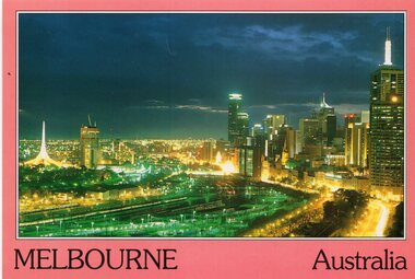
Postcard, Bartel Postcards, Melbourne from the Hilton Tower, early 1990's
Colour postcard red border, divided back - Bartel Postcards of a view of Melbourne from the Hilton Tower looking over the Flinders St rail yards at night. Back has space for name and address, stamp and a message and details of the postcard. Produced by Bartel Postcards possibly early 1990's Card No. BG006 Has "Melbourne Australia" along the bottom edge.trams, tramways, flinders st, melbourne, night photo, tram 2013 -
 Melbourne Tram Museum
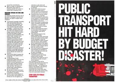
Pamphlet, Victorian Trades Hall Council, "Public Transport Hit Hard by Budget Disaster!", Aug. 1989
Folded A3 Sheet, colour printed, titled "Public Transport Hit Hard by Budget Disaster!", issued by 14 Unions, Victorian Trades Hall Council, dated August 1989, looking at the transport budget for 1989 - staff cuts, jobs, Met ticket system light rail proposal for Upfield, Western Bypass and action being taken by Unions to resist these cuts.trams, tramways, unions, transport, budgets, vthc -
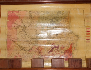 Bendigo Historical Society Inc.
Map - MARKS COLLECTION: GEOLOGICAL MAP OF IRELAND
Rolled map on wooden hanger, wooden rail on bottom. On top of map: 'geological survey of Ireland' On bottom LH side: the geology of this map published June 1855 by Sir R.I. Murchison, Director General, J. Beebe Jukes Local Director, surveyed by T. Oldham. Map part of Lansell material. On back of map at top written in black pen 'Ireland'.person, bendigo, george lansell -
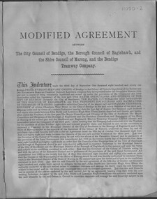 Bendigo Historical Society Inc.
Document - Modified agreement between the City of Bendigo, the Borough of Eaglehawk, and the Shire Council of Marong, and the Bendigo Tramway Company - draft/unsigned but dated 1891
Bendigo tramways conditions of operation including fares for a range of trips.Modified agreement between the City of Bendigo, the Borough of Eaglehawk, and the Shire Council of Marong, and the Bendigo Tramway Company - for the operation of a tramways service on two routes (rail station to Eaglemark Town Hall and Kangaroo Flat to White Hills Botanic Gardens Six-page agreement, unsigned or sealed by five nominated parties. Document is generally in a fair condition, bound with a light cover and stapled -
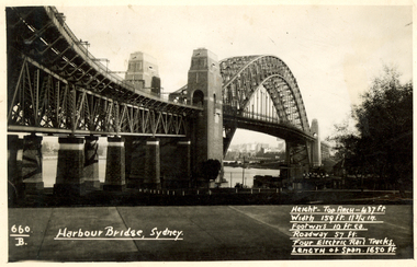 Federation University Historical Collection
Postcard, Kodak, Sydney Harbour Bridge, c1949, 13/10/1949
Postcard written by Frank Wright to a friend, W. Snelling in London. Frank Wright was a renown resident of Smeaton, where he was born. He lived at Laura Villa, and attended Smeaton State School. His father William was a gold miner and his mother's name was Sarah. Their family won many singing and instrumental awards. Frank was tutored by Percy Code and was awarded a gold medal for the highest marks in the ALCM examinations in the British Colonies at the age of seventeen years. He became the Australian Open Cornet Champion by the age of eighteen. A year later, Frank conducted the City of Ballarat Band, and later the Ballarat Soldiers’ Memorial Band. He formed the Frank Wright Frisco Band and Frank Wright and his Coliseum Orchestra. These bands won many South Street awards, and Frank as conductor won many awards in the Australian Band Championship contest. In 1933 Frank Wright sailed to England to conduct the famous St Hilda’s Band and was later appointed Musical Director of the London County Council, where he organized many amazing concerts in parks, in and around the London district. He was made Professor of Brass and Military Band Scoring and conducted at the Guildhall of Music and Drama. Frank was often invited to adjudicate Brass Band Championships around Europe, in Australia, including South Street and in New Zealand. The Frank Wright Medal at the Royal South Street competition is awarded to an individual recognized as making an outstanding contribution to brass music in Australia.Black and white photograph of the Sydney Harbour Bridge. A small section of the city and water can be seen beneath the arched span of the bridge.Written in white on front - 660.B, Harbour Bridge, Sydney., Height-Top arch - 437 ft.,Width 159 ft. 11 3/4 in., Footways 10 ft. ea., Roadway 57 ft., Four Electric Rail Tracks., Length of span 1650 ft. Handwritten on back - Message to W. Snelling in London from Frank Wrightfrank wright, cornet, conductor, sydney harbour bridge -
The Ed Muirhead Physics Museum
Photograph, Cyclotron accelerator
Builit in 1950s and used till the mid 1970s within the Physics Department used in Melbourne. John Rouse and David Caro was involved in the construction.Black and white photo of cyclotron (nuclear physics accelerator): inside dee lineSticky typed labels on back from top and left to right: “TUNING LOOP AND PORT, GUIDE RAIL, SHORTING BAR, COUPLING LOOP PORT, INSIDE DEE OUTER, 9” PUMP PORT, DEE STEM” Handwritten on back bottom left corner in pen: “inside the dee line”, “shooting bar, tuning loop and power loop, dee stem” -
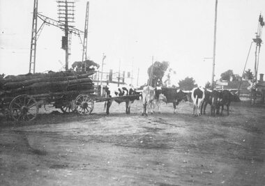 Ringwood and District Historical Society
Photograph, Old railway crossing near Ringwood station, c1925
Black and white photograph (2 copies- 1 large, 1 smaller)Typed below one photograph: "Bullock team at old railway crossing near station, taken from Maroondah Highway. Circa 1925." Written on back of other photograph: "Rail crossing 1924. Team owned by Hussey. Opposite Adelaide Street and Ringwood House. Corner of Station Street and Greenwood Avenue on right." Blood Brother's store in background. -
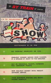 Melbourne Royal
Poster, W. M. Houston, By train of course, to Melbourne's Royal Show, 1958
A poster promoting the merits of travelling by train to the Royal Melbourne Show of 1958. The Showgrounds train station was one of the first buildings built on the Melbourne Showgrounds in Ascot Vale when the site was established in 1883, allowing patrons quick access to the venue despite it being slightly further out from the city than previous sites.A portrait poster, printed in colour; in the upper half of the poster there is an illustration showing a family of four, walking to the right; in the background is a photograph of a train station; the lower half of the poster consists of a list of the advantages of taking the train, printed on five horizontal stripes, white and green; colour process lithograph, linen-backed.BY TRAIN of course / TO MELBOURNE'S / ROYAL SHOW / SEPTEMBER 18 - 28, 1958/ NO PARKIGN PROBLEMS OR FEES / FREQUENT EXPRES SERVICE FROM FLINDERS ST. & SPENCER ST. RIGHT TO THE GROUNDS / DAY OR PERIODICAL TICKETS; COMBINED RAIL-ADMISSION TICKETS / NEW RAILWAY EXHBIIT WITH FREIGHT ADVISORY SERVICE / YOUR SUBURBAN STATION AHS DETAIL-PACKED PAHMPHLET /train, metro trains, showgrounds, melbourne showgrounds, royal melbourne show, 1985 melbourne royal show, melbourne royal show, showgrounds station, railway -
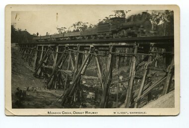 Orbost & District Historical Society
black and white photograph, Vogt. W.S, first half 20th century
This 97km Bairnsdale to Orbost extension through rugged terrain was reputed to have been the most difficult rail project undertaken in Victoria. This wooden bridge was one of the unique railway bridges of the East Gippsland Railway line. Mundic Creek Bridge is of unique design because the line crosses at a very sharp angle. This bridge like many others on the line have "disappeared". This one, probably because of a bushfire.The Bairnsdale to Orbost rail line contains the most varied range Of timber & timber composite bridges on any Victorian line. This photograph is a record of that. A black / white photograph of a train on a wooden railway bridge at Mundic Creek.on front - Mundic Creek, Orbost Railway W.S.Vogt, Bairnsdalemundic-creek-bridge east-gippsland-railway -
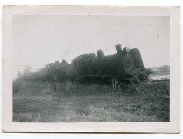 Orbost & District Historical Society
black and white photographs, 1950s
Dudley Charles Seymour Courtney , with a fellow worker, was trapped on the Orbost Raailwaay Station roof until rescued by an army duck. These photographs were his. He worked on the railway in Orbost from 1942 - 1952 approximately. During the 1952 flood nearly half of Orbost rail way station is washed away. The stationmaster and four members of his staff were rescued by police using army ducks.This is a pictorial record of a significant event in the history of Orbost.Nine small black / white photographs of a derailed train at a railway station. Derailed trucks and floodwaters can be seen. The photographs have a narrow white frame. Some are portrait and others landscape.on back of 3082.8 - hand-written in blue pen :"The floods worked the line from under the trucks in a couple of hours"floods-orbost orbost-railway-station rescue courtney-dudley-charles-seymour -
 Eltham District Historical Society Inc
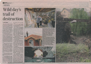
Booklet - Newspaper articles, Christmas Day Storm, 2011
A severe storm with damaging hail, rain and flooding impacted Melbourne on 25 December 2011 with particular damage to Eltham and Hurstbridge areas. The storm caused destablisation of parts of the Hurstbridge railway line. Wild day's trail of destruction, by Reid sexton, The Age, Tuesday, December 21, 2011, p4 Storm toll sparks rail safety fear, Reid Saxton, The Age, Tuesday, December 21, 2011, p52 newspaper articlesstorm, floods, flooding, christmas day, hurstbridge railway line -
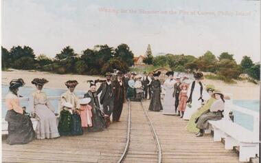 Phillip Island and District Historical Society Inc.
Photograph, Cowes Pier, Phillip Island, 1920
A group of twenty-two people seated and standing on the Cowes Jetty, which was built in 1870. Trolleys on iron rail were used to convey goods along the Jetty. Slightly obscured by people is the Jetty Shed, built in 1870 and now classified by National Trust. Beyond water and beach are trees and shrubs. One gap mid centre depicting The Isle of Wight Hotel - licensed in 1870 - and a large Norfolk Pine.Group waiting for ferry "Genista" on the Cowes Pier.Waiting for the Steamer on the Pier at Cowes, Phillip Islandlocal history, photographs, jetties, cowes, phillip island, colour tinted from black & white photograph, mary robb -
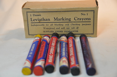 Kiewa Valley Historical Society
Box Crayons Marking, circa mid to late 1900's
These type of marking crayons have been in use from the 1800s onward to mark commercial and non commercial goods and articles that require waterproof and visual identification labels. Items such as bales of wool, tobacco tags, transportation tags(shipping, rail and road) and other "hard to mark" items that require information to be displayed by semi permanent waterproof signage. The crayons are also an advantage for young student art work.This particular box of leviathan crayons was in use by students in the Mount Beauty Primary School through the Victorian Education Supply Department. As the texture and adhesive/application qualities (soft medium and hard) allows students to be "creative" on various type of canvases. This type of application in schools is of a non commercial and simplistic art -form nature however more advanced students could present a commercial interest in a viable creative artistic venture. The major commercial and non educational uses are encompassed in a rural grazing and farming regions, of the Kiewa Valley and adjoining lands.The crayon box is made from cardboard and light buff colour. The box contains six "No.1" crayons, two of which have been used. Each crayon is wrapped with manufacturer's details on 180 gsm thick paper. The wrapper runs nearly 4/5 th of the entire length, leaving 1/5th open to display the colour of the crayon. The colours of the crayons are blue, purple, green, yellow, red and black. These crayons provide a waterproof writing, sketching and numbering method and are available in soft, medium and hard texture.Within a chain border and on two opposite sides of the box: "1 Dozen No.1", and below this and underlined "Leviathan Marking Crayons" and below this "Indispensable for all Marking and Checking purposes Waterproof and will not rub off", below this "SUPPLIED UNDER GUARANTEE"waterproof, freehand marking and artworks, school waterproof art, commercial identification marking of rural produce, school art, waterproof labelling -
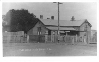 Lake Bolac & District Historical Society
Photograph - Black and white photograph, Lake Bolac Post Office - Glenelg Highway Lake Bolac c.1940s, c1940
Lake Bolac Post Office Glenelg Highway. Initially the Post Office was established at the Store in 1868. This official weatherboard building was opened in 1887 incorporating a telegraph office, money order office and post office savings bank. The Post Office business was relocated in 1944 and the building was used as a private residence with the front room leased to Dennys Lascelles. Note the horse hitching rail and kerosene street light.Photograph depicting a weatherboard building across a road. The building is fenced. In front of the building there is a telegraphic or electric post and a lamp post.lake bolac, post office, glenelg highway, dennys lascelles -
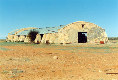 National Wool Museum
Photograph
Photo depicts Cordillo Downs Shearing Shed, located 176kms north of Innaminka. Donated by Gwen Cox (Hon. Staff Member). Once the largest sheep station in the world, the shearing shed had 120 stands. The wool clip had to be carted 600km down the track to the rail head at Farina by camel train. In 1883, a complete scouring plant was installed at "Cordillo". The region now (1989) carries cattle.shearing sheds, photographs, cordillo downs -
 Ballarat Tramway Museum
Document - List of drawings for Provincial tramways, State Electricity Commission of Victoria (SECV), c1950
Set of 15 typed sheets listing: 1 - Geelong tramways truck fittings and spare parts - 4 sheets 2 - Geelong track rail dimensions - 2 sheets 3 - Geelong track construction layout drawings - 6 sheets 4 - Bendigo - drawings of track sections - 1 sheet 5 - Bendigo - track plans - 1 sheet 6 - Bendogo - truck equipment and parts - 1 sheet Yields information about the drawings prepared by the SEC for Geelong and Bendigo - whether these still exist is questionable.Set of 15 typed quarto sheets within a manila card folder.tramcars, lists, geelong, bendigo, track work, plans, rails, parts, trucks, equipment -
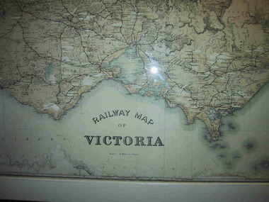 Parks Victoria - Mount Buffalo Chalet
Map, "Railway Map of Victoria"
Large framed map of Victoria, showing Victorias extensive rail network. Printed by Victorian Railways and is one of a number of 'framed pictures, particularly photographs of scenery, which have always been a feature of the Chalet.' (Pg 83. Historica, 2011) This map has been a permanent fixture situated in the hallway alongside the ballroom leading to the ski hire area since the 1950's and most likely earlier. Listed in Draft Inventory of Significant Collection ItemsLarge railway map of Victoria, Melbourne & Ballarat framed in white painted wood. Scale eight miles to one inch. Areas of the map have been whited out.Yes