Showing 8130 items
matching water
-
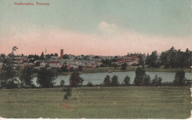 Rutherglen Historical Society
Image, c1920
Coloured Postcard of Rutherglen overlooking Lake King up to the Water Towerrutherglen, lake king, water tower -
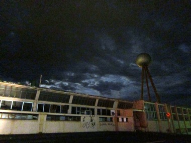 Ballarat Heritage Services
Digital photograph, Former Fletcher Jones factory at night with ball, c2010-2017
Digital Image of the former Fletcher Jones Factory, with ball water tower.fletcher jones, warrnambool, night, factory, water tower -
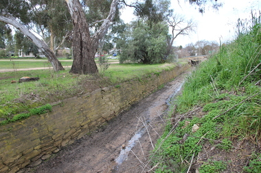 Ballarat Heritage Services
Photograph - Colour, L.J. Gervasoni, Channel near the Avoca River, Avoca, 2011, 06/08/2011
Colour photograph of a stone water channel near the Avoca River in Avoca. avoca, bridge, avoca river, channel, stone, drystone -
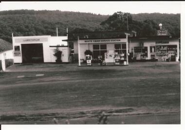 Brown Hill Progress Association Inc.
Service Station, White Swan Garage
The White Swan Garage, Service Station. Water Street Brown Hillwhite swan service station, brown hill, petrol station -
 Lakes Entrance Regional Historical Society (operating as Lakes Entrance History Centre & Museum)
Photograph, Lakes Post Newspaper, 1995
Black and white photograph of water reservoir at unamed site Kalimna Victoriapublic health -
 Queenscliffe Maritime Museum
Machine - Outboard Motor
Featured variable pitch propeller for reverse, exposed gear driven magneto, steering via a rudder.Single cylinder water cooled 2 stroke Waterboy outboard motor. outboard motor, waterboy -
 Stawell Historical Society Inc
Memorabilia - Realia, 1860's
Bitumised Paper Water Pipe used in Patrick Street 1860'sstawell -
Stawell Historical Society Inc
Memorabilia - Realia, c1930's-1950's
Pink Floral Lustreware Water or Milk Jug Kensington Ware Englandstawell -
Stawell Historical Society Inc
Memorabilia - Realia, 1970's
Hemley's Soft drink Bottle from Callawadda. Hemley's Aerated Water stawell -
 Millewa Community Pioneer Forest & Historical Society
Hot Water Bottle, Sunrise Stainless
Used as a bed warmer by the Boston Family Representative of bed warmers used by pioneers on frosty Millewa nightsStainless steel hot water bottle for bed warming, screw in stopperSunrise Stainless Steel CO MELB PAT APPN 6368/42boston, hot water bottle, millewa, warming -
Federation University Art Collection
Bookplate, ‘Ex Libris Edwin Jewell’
After a quiet period, interest in bookplates in Australia began to increase in the early 1970s, Entrepreneurial art and book collectors such as Edwin Jewell and others commissioned multiple Bookplate designs from a range of well known fine artists. At a 1997 meeting in Melbourne of the Ephemera Society of Australia Edwin Jewell and others announced the formation of the Australian Bookplate Society. The society was instrumental in promoting the art of the bookplate through establishment of the Australian Bookplate Design competition.The book plate depicts framed gum trees by water with hills in the backgroundFred Kluxbookplate, printmaking, australian bookplate design awards, keith wingrove memorial trust -
 Federation University Art Collection
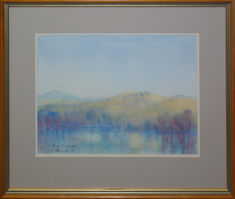
Painting, 'Murray River Flood Plain', by David Alexander, 2004
David ALEXANDERFramed watercolour landscape depicting water in the foreground and mountains in the mid-ground.Signed and dated in ink lower left "DA Alexander '04"art, artist, david alexander, murray river, gippsland campus, landscape, watercolour, churchill -
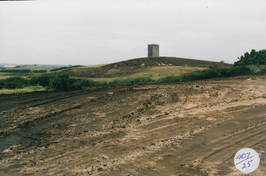 Port Fairy Historical Society Museum and Archives
Photograph
South Beach Development Coloured photograph of Earthworks in foreground with Port Fairy Water tower in background407/25 (since removed 2021)south beach, development, water tower, road making, street, earth works -
 Mont De Lancey
Kettle, c1897
Silver footed hot water kettle with lid and milk glass handlekitchenware, kettles -
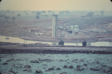 Bendigo Historical Society Inc.
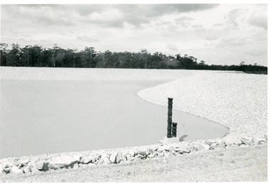
Slide - LAKE EPPALOCK(THE BEGINNING), June 1061
Slide. Lake Eppalock(The Beginning). Construction of the Water Tower near the wall.slide, bendigo, lake eppalock(the beginning) -
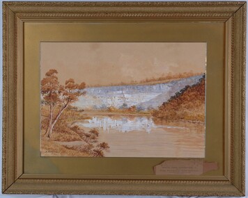 Glenelg Shire Council Cultural Collection
Painting, A.S. Murray, Scene on the River Glenelg, c. 1894
Art Collection Previously located in History HouseThe painting depicts a large body of water surrounded by hills. The body of water extends from the front right corner through to the centre of the work. Predominately depicted in shades of brown, the body of water has a white centre with three birds (swans) sitting on the surface. In the foreground to the left of the water is a riverbank with a large brown tree. The background consists of a large blue/grey hillside and brown cloudless sky. The work has a gilded ornate frame with a gold mount and exposed canvas.Front: A.S. Murray Back: W.HAMER, 189 Sturt Street, Ballarat, VICTORIA BUILDINGS, OPPOSITE CITY FIRE BRIGADElandscape, glenelg river -
 Ringwood and District Historical Society
Map, Plan of Country Lands in the Parishes of Nunawading Ringwood and Scoresby - circa 1855
Blueprint copy of Survey Map detailing original Selectors' names and property locations. List of Parish map references including property bearings, distances in Links, and markings on trees. Descriptive remarks include areas marked "Farmer's Common", "Poor soil thickly/moderately timbered with stringy bark", and location of water and firewood reserves."Surveyed and plotted by N.M. Bickford, Superintendant of Mr. Hodgkinson's Field Party". "The land comprised in this survey is of inferior quality, moderately undulating, and thickly wooded. It is watered by Dandenong Creek and Deep Creek." Inset map showing location of (*proposed) cemetery on southern corner of Lillydale Road from Melbourne and Sawmill Road, later Mount Dandenong Road. (*Cemetery did not eventuate.) -
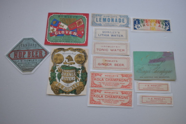 Warrnambool and District Historical Society Inc.
13 labels, Rowley
In 1868 John Rowley opened a soda water manufactory attached to the Corio Brewery and this was renamed the Warrnambool Steam Aerated Works in 1872. By the 1880s his factory at the corner of Timor and Banyan Streets was occupying half an acre of land , employing 13 people and manufacturing 20 varieties of drinks. Following Rowley's death the factory and plant was sold but the cordial manufacturing business continued for some years. These labels are of great significance as John Rowley was a dominant name in the cordial making business in Warrnambool..1 Rectangular , red, green, blue and white label featuring text, two flags with lions, a sailing ship, a sheep and a sheaf of wheat. There is a scroll with text. A white decorative border surrounds the label. It is adhered to a piece of red thin cardboard. .2 Irregular shaped label with gold and green decorations on a white background and text. The decorative pieces include grapes, vine leaves, flowers, the profile of a wolf, and two medallions with the coat of arms of Warrnambool There are two scrolls with text The label is adhered to a piece of white card. .5 Rectangular Multi coloured label with text adhered to a piece of white paper .4 Rectangular green card with text .3 Hexagonal grey/green label with black and red text and decorative black dotted curls mounted on white paper .6 White rectangular label with blue text and decorative surround of leaves and flowers. It has damage to three corners. .7 White label with blue text and decorative border adhered to white paper. .8 Pale pink rectangular card label with rose coloured text and a decorative border. .9 Cream rectangular label with red text and decorative border adhered to a piece of white paper 10.1, 10.2 Cream rectangular labels with red text. .2 is adhered to white paper. 11.1, 11.2 Cream rectangular labels with red text and borders adhered to white paper..1 ROWLEY'S STANDARD CLOVES WARRNAMBOOL COLOURED WITH BURNT SUGAR .2 Warrnambool NULLI SECUNDUS BY THESE WE FLOURISH STANDARD ORANGE BITTERS J.S.ROWLEY .3 STANDARD HOP BEER J.S. ROWLEY AERATED WATERS & CORDIAL MANUFACTURER WARRNAMBOOL .4 Rowley's SPARKLING Ginger Champagne NON ALCOHOLIC AND INVIGORATING .5 WARRNAMBOOL J.S.ROWLEY'S GINGERALE. TO HIS EXCELLENCY LORD BRASSEY K.G.B. .6 ROWLEY'S LEMONADE MANUFACTURED WITH THOROUGHLY FILTERED RAIN WATER WARRNAMBOOL .7 ROWLEY'S LITHIA WATER .8 ROWLEY'S TONIC WATER .9 ROWLEY'S GINGER BEER .10.1 ,10.2 ROWLEY'S KOLA CHAMPAGNE A Most Highly Refreshing and Excellent Beverage. Its properties are unequalled for preventing fatigue. .11 J.S ROWLEY, MANUFACTURER WARRNAMBOOL & HAMILTON CONTENTS APPROXIMATELY 25 OZ. THIS CORDIAL DOES NOT CONTAIN ANY PRESERVATIVE .2 Warrnambool NULLI SECUNDUS BY THESE WE FLOURISH STANDARD ORANGE BITTERS J.S ROWLEY john rowley, cordial manufacture -
 Halls Gap & Grampians Historical Society
Photograph - B/W, c 1844
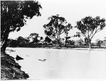
This property was known as Mokepilly Station ( name on back of photo is spelt 'Mokepilli'.For further reference see p.2,p.92,116,119,121, Victoria's Wonderland.Photo shows a body of water in foreground with a collection of buildings on opposite bank. there are a number of large gum trees on both sides of water. The buildings appear to be a farmhouse and outbuildings that have thatched roofs. There is extensive fencing.buildings, houses -
 Lakes Entrance Regional Historical Society (operating as Lakes Entrance History Centre & Museum)
Photograph, Lakes Post Newspaper, 1996
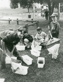
Black and white photograph of small group of children one named as Scott Froud on bank of Tambo River, with nets and buckets of water, samples collected for the water watch program at primary school Johnsonville Victoriaschools -
 Bendigo Historical Society Inc.
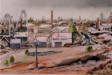
Photograph - JOHN HALL COLLECTION: PHOTO OF THE ORIGINAL WATER COLOUR PAINTING: DUCHESS TRIBUTE MINE CALIFORNIA GULLY
JOHN HALL COLLECTION: PHOTO OF THE ORIGINAL WATER COLOUR PAINTING: Duchess Tribute Mine California Gully Written on the rear: Duchess Tribute Cal Gully Water colours by John Hall (dec) EaglehawkJohn Hallartwork, water colour, gold mines -
 National Vietnam Veterans Museum (NVVM)
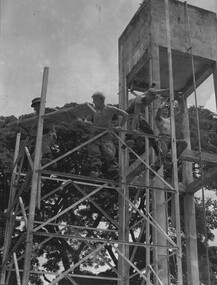
Photograph, Gibbons, Denis, Hoi My Southern Cross Windmill 2
Denis Gibbons (1937 – 2011) Trained with the Australian Army, before travelling to Vietnam in January 1966, Denis stayed with the 1st Australian Task Force in Nui Dat working as a photographer. For almost five years Gibbons toured with nine Australian infantry battalions, posting compelling war images from within many combat zones before being flown out in late November 1970 after sustaining injuries. The images held within the National Vietnam Veterans Museum make up the Gibbons Collection. A black and white photograph of engineers constructing a Southern Cross Windmill tower next to the water header tower in Hoi My. The ultimate aim of the construction was to have a reasonable water supply for the villagers at Hoi My.photograph, engineers, hoi my southern cross windmill, 1st australian civil affairs unit, gibbons collection catalogue, vietnam war, denis gibbons, photographer, hoi my, diggers -
 Lakes Entrance Regional Historical Society (operating as Lakes Entrance History Centre & Museum)
Photograph - Footbridge, 1993c
Black and white photograph showing left hand side angle of crowd of tourists crossing footbridge to ocean during Clear Water Festival. Body of water in foreground is the Cunninghame Arm. Lakes Entrance Victoria bridges, festival, tourism -
 Bendigo Historical Society Inc.
Document - DRAINAGE PROBLEMS - NEW CHUM MINES DRAINAGE PROBLEMS 1910
Handwritten extract from the Bendigo Advertiser 20/8/1910 Page 8. ''New Chum Mines. Unwatering of the deep levels is being carried on as expeditionsly as was expected by the authorities. In the last four days, the water has only been lowered 14 feet at the Victoria Quartz Mine. The water stood at the 3,226 feet level yesterday. The slow progress being made this week is no doubt due to the large quantity in the workings at some of the levels.'' From the Bendigo Advertiser 27/8/1910 Page 9. ''New Chum Mines. Very slow progress being made. At Victoria Quartz, the water was lowered 32 feet for the week, and is now at 3258 feet. New Chum Railway lowered the water 17 feet and the present level of the water is at 1796 feet. The Lazarus are raising water from 2157 feet. The water has ceased flowing into the New Chum and Victoria through the connecting level with the Lazarus Mine at about 2,500 feet. As the Victoria Quartz is down 4,614 feet, there is still a considerable quantity of water to get out before sinking of the shaft can be resumed.''document, gold, drainage problems, drainage problems, new chum mines drainage problems 1910, bendigo advertiser 20/8/1910 page 8 & 27/8/1910 page 9, new chum mines, victoria quartz, new chum railway, lazarus, new chum and victoria -
 The Beechworth Burke Museum
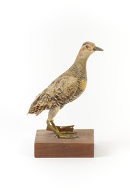
Animal specimen - Buff-Banded Rail, Trustees of the Australian Museum, 1860-1880
The Buff-banded Rail is located on mainland Australia. It can also be found in south-east Asia, New Guinea and New Zealand. These birds are often seen individually or in pairs walking through the dense reeds and vegetations of wetlands or crops. This rail has a slow walk and often flicks its tail, which is raised, as they move. They are omnivore scavengers who feed on a large variety of invertebrates, fruit, seeds and vegetables. This specimen is part of a collection of almost 200 animal specimens that were originally acquired as skins from various institutions across Australia, including the Australian Museum in Sydney and the National Museum of Victoria (known as Museums Victoria since 1983), as well as individuals such as amateur anthropologist Reynell Eveleigh Johns between 1860-1880. These skins were then mounted by members of the Burke Museum Committee and put-on display in the formal space of the Museum’s original exhibition hall where they continue to be on display. This display of taxidermy mounts initially served to instruct visitors to the Burke Museum of the natural world around them, today it serves as an insight into the collecting habits of the 19th century.This specimen is part of a significant and rare taxidermy mount collection in the Burke Museum. This collection is scientifically and culturally important for reminding us of how science continues to shape our understanding of the modern world. They demonstrate a capacity to hold evidence of how Australia’s fauna history existed in the past and are potentially important for future environmental research. This collection continues to be on display in the Museum and has become a key part to interpreting the collecting habits of the 19th century.This specimen is in a standing position on a wooden platform. The Buff-Branded Rail has a pale grey/yellow eyebrow over the orange glass eyes and a pale grey bill. It also has an orange and brown coloured band on its breast. This bird is multicoloured with streaks of chestnut brown, black, white and a faint orange-brown. This specimen has a paper identification tag tied to its left leg.29 c. / (22c)? Spotted Water Crake / See Catalogue, page, 35. / taxidermy mount, taxidermy, animalia, burke museum, beechworth, australian museum, skin, reynell eveleigh johns, bird, landrail, buff-banded rail -
B-24 Liberator Memorial Restoration Australia Inc
Flying Log Book W/O P.B.Adams
W/O P.B. Adams qualified mas an WAG on B-24 Liberators from 07.04.1944 until 31.05.1945Rectangular blue linen bound hard cover book, covered in brown paperBook cover water damaged, brown paper cover----R.A.A.F. LOG BOOK -
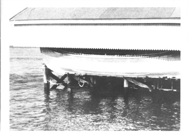 Queenscliffe Maritime Museum
Photograph - Photograph of the lifeboat Queenscliffe under cover
black and white photographoar & sail lifeboat Queenscliffe stored out of the water and under hard coverlifeboats -
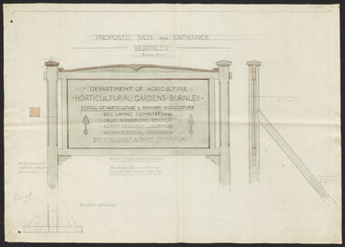 University of Melbourne, Burnley Campus Archives
Plan, Proposed Sign for Entrance to Burnley, 1931
(1) Correspondence between Mr Zevan (Government Cool Stores), the Agricultural Superintendent, R. Crowe (Exports Superintendent) and A.W. Jessep re design for new entrance gates at Burnley Gardens, between 31.03.1931 and 09.07.1931. Invoice from signwriter. (2) Pencil sketch of proposed design with anotations. (3) Coloured drawing to scale.On verso of drawing: "Gate sign & Watering plans" and "File State Public Works"mr zevan, cool stores, r. crowe, exports, a.w. jessep, burnley gardens -
 Bendigo Historical Society Inc.
Document - DRAINAGE PROBLEMS - INRUSH OF WATER AT THE VICTORIA QUARTZ
Two handwritten copies of a Bendigo Advertiser report 16/6/1910 Page 7. This is a longer version of 3600.14. It was thought that the rush of water was from a dam bursting in one of the other mines, but as the water showed no signs of slowing that theory was discarded. The temperature of the incoming water was much higher than the Victoria Quartz was accustomed to bail, and this circumstance is significent in view of the increased temperature of the water at the deep levels in the New Chum Railway. Some months ago, the water commenced to flow from the New Chum Railway workings into the New Shenandoah, which is the next mine north. The water rose so rapidly that a disaster was narrowly averted. The mines along the line were connected at different levels and with the cessation of bailing at the deep levels in the southern mines, it was only to be expected that the water would find its way north to the Victoria Quartz. The water raised from the operating mines under the direction of the New Chum Drainage Association, a yeart or two ago used to exceed six million gallons per month. At that time there were eight companies bailing water, and even then some of the plants, especially those at the deep mines, were severely taxed in coping with the water, and performing ordinary work. Since some mines had discontinued bailing, the water has been filling up extensive workings, and as was predicted in the ''Advertiser'' some time ago, the Victoria Quartz Company could not expect to succeed with its deep sinking project without making some special provision for raising the water, which ultimately would become a source of trouble. The Victoria Quartz Company was allotted a special grant of 10,000 pound to assist in sinking the shaft 1000 ft from the 4254 ft level. Under the conditions of the grant, the Company had to contribute half the cost of the sinking, and the raising of the water has also been an exensive item. For the present, all attention will be concentrated in lowering the water, and should the appliances prove unequal to the task the deep sinking scheme can only be accomplished by resorting to some comprehensive system of combating the water'. Document from Albert Richardson Collection of mining history.document, gold, drainage problems, drainage problems, inrush of water at the victoria quartz, bendigo advertiser 16/6/1910 page 7, mine reports 13/6/1910, victoria quartz, lansell's 180, mr stevens, mr w abraham, new chum & victoria mine, new chum railway, new shenandoah, new chum drainage association -
Churchill Island Heritage Farm
Domestic object - meat safe, circa 1920s
Meat safes were used to keep meat and vegetables cooler before the availability of ice and then kerosene or electric refrigerators. The safe would be hung in the shade on a tree by a hook on the top,and pieces of damp hessian would be hung over each side. As the wind hits the hessian it causes the water to evaporate and the items inside the safe to stay cooler. This meant that the items inside the safe would last a day or two longer.Painted pale green safe. Rectangular grid pattern of ventilation holes with circles of ventilation holes within the pattern. Surface rust patches. Water reservoir and wire hook added later on top. Internal trays bottom and 1/2 way. Door detached - hinges rusted away. No base apart from shelf. Hanger missing.churchill island, meat safe, kitchen object