Showing 2908 items matching "high street road"
-
 Kew Historical Society Inc
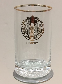
Award, Kew Bowling Club, Embossed Glass Trophies, 1980s
... High Street Kew melbourne Sports Clubs in Kew in the final decades of the 19th century and in the early 20th century were often umbrella organisations with facilities for a number of sports. Typically in Kew, this included teams in lawn bowls, tennis and croquet. The Kew Bowling Club was formed in 1880 while the privately owned Auburn Heights Recreation Club was opened in 1904. By 1998, the two Clubs decided to amalgamate at the Auburn Heights site in Barkers Road ...Sports Clubs in Kew in the final decades of the 19th century and in the early 20th century were often umbrella organisations with facilities for a number of sports. Typically in Kew, this included teams in lawn bowls, tennis and croquet. The Kew Bowling Club was formed in 1880 while the privately owned Auburn Heights Recreation Club was opened in 1904. By 1998, the two Clubs decided to amalgamate at the Auburn Heights site in Barkers Road, forming the Kew Heights Sports Club. The combined club was itself taken over by the Melbourne Cricket Club in 2012 becoming MCC Kew Sports Club. In 2017 MCC Kew closed and its landholding was subsequently sold to Carey Baptist Grammar School. Two glass trophies won by Saul Spielmann at the Kew Bowling Club, at which Saul wa sat one stage the Secretary.saul spielmann, kew bowling club -
![No.2 [Steam] Roller, Kew City Council](/media/collectors/550653872162f11fb04854aa/items/5c31f69121ea670d8459a8b6/item-media/5c31f77a21ea670d845a8063/item-fit-380x285.jpg?cb=6) Kew Historical Society Inc
Kew Historical Society IncPhotograph, No.2 [Steam] Roller, Kew City Council, c.1950
... Kew Historical Society Inc Kew Court House 188 High Street Kew melbourne The Number 2 Steamroller was used in public road building in Kew.It replaced the first Council steamroller which was used between 1915 and 1932. ...The Number 2 Steamroller was used in public road building in Kew.It replaced the first Council steamroller which was used between 1915 and 1932.Rare photograph of a Kew City Council piece of road making machinerySmall black and white photograph of a steamroller used by the City of Kew in road construction from the 1930s to the 1950s.Reverse of photo: "KCC No 2 Roller 607S". Accompanying note: "20/3/84 Gift to the Society from Mr [?] who was K.C.C. [Kew City Council] driver of this "monster". Kew City Council No.2 Roller. Used in street construction 1950. Roller probably 1930 era."road construction - kew (vic), no.2 steamroller, steamrollers - kew (vic) -
 Kew Historical Society Inc
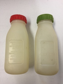
Container - Model Dairy Plastic Milk Bottles, Model Dairy, c.1960
... Kew Historical Society Inc Kew Court House 188 High Street Kew melbourne This pair of milk bottles, produced for the Model Dairy in Cotham Road, Kew, were donated by Vik Sabaliauskas. ...This pair of milk bottles, produced for the Model Dairy in Cotham Road, Kew, were donated by Vik Sabaliauskas. They belonged to his father who worked at Model Dairy in the 1950s and 1960s. Vik wrote about his father: "As for my father, his whole life story is interesting. He was part of the big immigration program after WW2. He was a displaced person in Germany like lots of others who came out looking for a new life. Our family name is actually SABALIAUSKAS which is of Lithuanian descent. My Dad was also named Vik (Viktoras). He was known as Big Vik and I was little Vik. He arrived in Australia in 1947 and then did his 2 years of work organised by the Government and then he came to Melbourne. We lived in Tyler St Preston and he rode his pushbike to and from Kew every working day for years. In my estimation that was about 13 kms for about 6 or 7 years. Imagine that happening today. Freezing Winter mornings and hot Summer afternoons. His English was poor but he had a great work ethic like all European immigrants. His duties related to maintaining and operating all the machines. One story that he told me about was that after I was born (in 1959) he made friends with one of the drivers who delivered milk to the dairy. He asked him to get a container of milk from the farmer everyday which was just for me. I remember going to the Model Dairy Family Christmas parties which were always well patronised. I also remember visiting him in the PANCH Hospital (Bell Street Preston) where he was treated for kidney stones caused by drinking very creamy milk. He wasn't happy when he was told by the doctor to cut back on milk. My Dad was one month short of his 95th birthday when he died and he lived a pretty healthy life." (2019)Kew was a major milk producing district in the Nineteenth and early Twentieth centuries, with three major dairy farms lining the Yarra between Studley Park in the west and Burke Road in the east. In addition to these dairy producers, there were also a number of accredited dairy retailers in the suburb. The largest and most enduring of these was the Model Dairy founded by the Kew pioneer James Venn Morgan. Milk bottles that include the name of the producer or retailer are historically significant as they represent a period in Kew's history before the mass production of milk in the second half of the Twentieth Century. A number of these named bottles have the additional attribute of rarity.Pair of plastic milk bottles, designated on the front as to be used in the refigerator on on picnics. One bottle has a red screw on lid and the other a green lid. The bottles are semi-transparent. [The record also includes a photograph of Vic Sabaliauskas, provided by his son. The photograph dates from the period when he was employed at the Model Dairy].Impressed on the front of both bottles: "Unbreakable picnic and refrigerator bottle made expressly for Model Dairy Pty Ltd Cotham Rd Kew"dairies - kew, model dairy - cotham road - kew (vic) -
 Kew Historical Society Inc
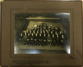
Photograph, Reunion , Past and Present Members of Kew Presbyterian Young Mens' Bible Class, 1924, 1924
... Kew Historical Society Inc Kew Court House 188 High Street Kew melbourne The Kew Presbyterian Church was located in Cotham Road, Kew on the corner of Highbury Grove. ...The Kew Presbyterian Church was located in Cotham Road, Kew on the corner of Highbury Grove. The Church Hall was located next door in Highbury Grove. On amalgamating with the Uniting Church the buildings became redundant and are now the Kew Chinese Baptist Church.Original photograph from 1924 that records the preoccupations of committed church goers in Kew in th e1920s.Posed photograph of Reunion of Past and Present Members of Kew Presbyterian Young Men's Bible Class. The men are seated in 5 rows on a raised wooden floor. Wooden board hanging on the wall behind the men reads Presbyterian Church of Victoria. Possibly the church hall with stage curtains On front Reunion Past and Present Members of Kew Presbyterian Young Mens' Bible Class. 1924" On reverse "Reunion Some of the Past and Present Members Oct 1924. Unclear ?YMBC"kew presbyterian church, presbyterian churches - kew (vic), bible classes -
 Kew Historical Society Inc
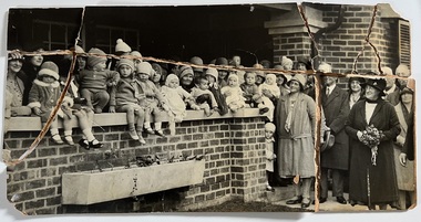
Photograph - Peel Street Health Centre : Official Opening, 1930
... Kew Historical Society Inc Kew Court House 188 High Street Kew melbourne The North Kew Centre was the third established at North Kew. It followed a lease of a house at 50 Willsmere Road. ...The North Kew Centre was the third established at North Kew. It followed a lease of a house at 50 Willsmere Road. The Peel Street building was designed by Mr Chipperfield. Messrs McIntosh and Taylor were the successful tenderers, the price being 1,240 pounds. The North Kew Baby Health Centre was finally opened on 18 June 1930 in the presence of the mayor, councillors and citizens of Kew, and representatives of the Infant Welfare Council. A report in The Age of 19 June described the opening in detail as well as the features of the new Centre. These included: "The rooms ... filled with flowers, pink and mauve hydrangeas and native heath, and the walls are adorned, with a charming frieze, representing windmills, flocks and a fairy tale goose girl. On the walls are hygiene editions of the funniest of Belloc's "Cautionary Tales" revised as posters, Outside there is promise of a gay garden, and a lovely view of green fields sloping to a shining bend of the river." Early photographic record of the opening of an early baby health centre in Kew.[Badly damaged] black and white photograph of the opening of the North Kew Baby Health Centre in Peel Street. The photo is mounted on card, and shows mothers and their children on the veranda, and officials at right. The latter includes the Mayoress and probably Vera Scantlebury. All mothers wear hats as do most of the children. [When the photograph was presented to the Society in 1979, it was described in the first Acquisitions Register as framed. Some time after that it was removed from its frame and badly broken. A separate photocopy of the original photograph is also held in the collection.]Earliest inscription: "Peel Street Health Centre / Official Opening 1930 / donated by Sr Costello and Sr Bewish [sic] 1979 / Copy purchased by ..... for Centre". Old Accession number in Texta: "KH-133 Kew Historical Society". Separate later label: "Opening North Kew Baby Health centre 1930". north kew baby health centre, peel street (kew), baby health centres - kew (vic) -
 Kew Historical Society Inc
Photograph, Fancy Dress Social, Kew Presbyterian Church Hall, 1922, 11/1922
... Kew Historical Society Inc Kew Court House 188 High Street Kew melbourne The Kew Presbyterian Church was located in Cotham Road, Kew on the corner of Highbury Grove. ...The Kew Presbyterian Church was located in Cotham Road, Kew on the corner of Highbury Grove. The Church Hall was located next door in Highbury Grove. On amalgamating with the Uniting Church the buildings became redundant and are now the Kew Chinese Baptist Church.Original photograph from the 1930s that records the kinds of social and spiritual actions of church goers in Kew. Group photograph of participants in a fancy dress social at the Kew Presbyterian Church Hall in 1922. It is believed that the group was the Young Men's Bible Class who held this event annually. The Society has photographs of the event in 1922 and 1925.Later hand: "Masked Fancy Dress Social, Kew Presbyterian Hall, November 1922"presbyterian church - kew (vic), kew presbyterian church - young men's bible class, churches - social activities - 1920s -
 Kew Historical Society Inc
Photograph, Fancy Dress Social, Kew Presbyterian Church Hall, Kew, 1925, 1925
... Kew Historical Society Inc Kew Court House 188 High Street Kew melbourne The Kew Presbyterian Church was located in Cotham Road, Kew on the corner of Highbury Grove. ...The Kew Presbyterian Church was located in Cotham Road, Kew on the corner of Highbury Grove. The Church Hall was located next door in Highbury Grove. On amalgamating with the Uniting Church the buildings became redundant and are now the Kew Chinese Baptist Church.Original photograph from the 1930s that records the kinds of social and spiritual actions of church goers in Kew.Group photograph of young men in attendance at a fancy dress social at the Kew Presbyterian Church Hall in 1925. The photo would indicate that the event was a young men only event. The Society has photographs of the event in 1922 and 1925.Later hand: "1925. Annual Fancy Dress Social. Kew Presbyterian Young Men's Bible Class"presbyterian church - kew (vic), kew presbyterian church - young men's bible class, churches - social activities - 1920s -
 Kew Historical Society Inc
Photograph, Cast Members, Kew Presbyterian Church, 1925-1935
... Kew Historical Society Inc Kew Court House 188 High Street Kew melbourne The Kew Presbyterian Church was located in Cotham Road, Kew on the corner of Highbury Grove. ...The Kew Presbyterian Church was located in Cotham Road, Kew on the corner of Highbury Grove. The Church Hall was located next door in Highbury Grove. On amalgamating with the Uniting Church the buildings became redundant and are now the Kew Chinese Baptist Church.Original photograph from the 1930s that records the kinds of social and spiritual actions of church goers in Kew.Members of the cast of a performance take a certain call at the end of a performance. The item was part of a group of photos relating to the Kew Presbyterian Church, so it may show a performance in which members of the church participated or led. The location of the performance is unclear; it might be at the Kew Recreation Centre or in the Kew Presbyterian Church Hall. Intriguingly, what look to be bunya bunya pines appear in the distance above the proscenium. The photograph was originally identified as possibly being the Kew Light Opera Company, however the photograph precedes its foundation. It is more likely to be a performance by a church group.cast photographs, theatre - melbourne -
 Kew Historical Society Inc
Photograph, Photograph of the Assembled Cast, 1925-1935
... Kew Historical Society Inc Kew Court House 188 High Street Kew melbourne The Kew Presbyterian Church was located in Cotham Road, Kew on the corner of Highbury Grove. ...The Kew Presbyterian Church was located in Cotham Road, Kew on the corner of Highbury Grove. The Church Hall was located next door in Highbury Grove. On amalgamating with the Uniting Church the buildings became redundant and are now the Kew Chinese Baptist Church.Original photograph from the 1930s that records the kinds of social and spiritual actions of church goers in Kew.Members of the cast of an unidentified performance, probably during the 1930s in Kew, pose for a group photograph. The photograph was originally identified as possibly being the Kew Light Opera Company, however the photograph precedes its foundation. It is more likely to be a performance by a church group.cast photographs, theatre - melbourne -
 Kew Historical Society Inc
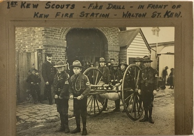
Photograph, 1st Kew Scouts Fire Drill, 1911, 1911
... High St" 1st Kew Scouts undertaking a fire drill in front of the old Kew Fire Station in Walton Street, Kew. The reverse details the names and addresses of the Scouts featured in the photograph. An integral part of the Scout program is service to others and working with the fire brigade would have been just one of many such training activities enthusiastically undertaken by the Scouts. The Kew Fire Brigade had hand-drawn fire appliances up until 1919 when a motorised vehicle was purchased. The fire station was replaced by the Belford Road ...A Volunteer Fire Brigade was established in Kew in 1879 and a fire station established in Walton Street, Kew. The Brigade was formally disbanded by the Fire Brigade Act of 1890 and the volunteers replaced by a unit of the Metropolitan Fire Brigade in 1891. The building shown in this rare photograph was constructed in 1893. In the background can be seen a house on the corner of Walton and Peel Streets, one of two, built in 1893 for firemen of the Brigade. An article in The Weekly Times (1 April 1911) records that: "Kew Troop - A,S.M. Williams reports:- The troop under S.M. Kellett. marched to the Kew Fire Brigade station, to receive instruction in fire drill from Mr Gross, the officer in charge, but as he was unexpectedly called away, the S.M. S and A.S.M had to instruct the Troop. Every boy was taught how to sink the hydrant, and how to couple and uncouple the hose. The hose reel was then brought into action, and the boys were divided into sets of six, each division taking its turn in pulling the reel up a hill to the water plug, where the hydrant was quickly sunk by one Scout, two more uncoupling the hose and coupling it on to the hydrant. We have gained four recruits during the last week, and are expecting two more next week."This is a fine, original photograph, probably taken by a commercial photographer, showing the 1st Kew Scouts in front of the old Kew Fire Brigade building in Walton Street in 1911. The building, constructed in 1893 was later demolished in 1941. This is a rare historic photograph of the Station. Unfortunately the name of the photographer is unrecorded.1st Kew Scouts undertaking a fire drill in front of the old Kew Fire Station in Walton Street, Kew. The reverse details the names and addresses of the Scouts featured in the photograph. An integral part of the Scout program is service to others and working with the fire brigade would have been just one of many such training activities enthusiastically undertaken by the Scouts. The Kew Fire Brigade had hand-drawn fire appliances up until 1919 when a motorised vehicle was purchased. The fire station was replaced by the Belford Road station in 1941 and subsequently demolished. Front: "First Kew Scouts - Fire Drill - In front of Kew Fire Station - Walton St. Kew" Reverse: "Walton St Kew / Kew Fire Station / Mr Gross o/c Fire Station / Bert Gundy Clark, part-time fireman / Allan Sewell Gellibrand St. / Clappy Williams Hawthorn ? / Allan Barrett Cobden St / Allan Woollard High St"kew fire brigade - walton street, scout groups --- kew (vic), 1st kew boy scouts -
 Kew Historical Society Inc
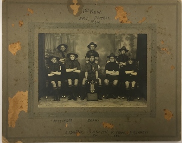
Photograph, 1st Kew Scout Group, 1st Kew Emu Patrol, 1924, 1924
... High Street Kew melbourne The 1st Kew Scouts was one of the first Scout Troops in Victoria, being formed in 1909. From 1927 they met in a magnificent Scout Hall in Disraeli Street, Kew until it was demolished in 1993. Still operating (in 2020) from their new Scout Hall on the corner of Kilby Road ...The 1st Kew Scouts was one of the first Scout Troops in Victoria, being formed in 1909. From 1927 they met in a magnificent Scout Hall in Disraeli Street, Kew until it was demolished in 1993. Still operating (in 2020) from their new Scout Hall on the corner of Kilby Road and Kellett Grove, Kew.A Scout Troop is divided into smaller teams called ‘patrols’. At this time the Scout in charge of a patrol was called a patrol leader (‘PL’) and his assistant a ‘second’ (‘Sec’). Each patrol of boys would chose a patrol name, often an Australian animal or bird. Other 1st Kew patrols called themselves the Kookaburra Patrol, the Kangaroo Patrol and so forth. The shield the Emu patrol is proudly displaying is possibly the trophy for being the ‘Champion Victorian Patrol’. Some of the Scouts pictured are identified on the mount of the photograph.Back row left and centre: "Pettinger, Evans" Front row left to right: "J. Edwards, R Craven [PL], R.T. Timms [Sec], P. Bennett scouts - kew, 1st kew scouts, kew fire brigade - walton street -
 Kew Historical Society Inc
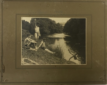
Photograph, Edwin Anderson, 1st Kew Scouts, Water Rescue Training, 1924
... High Street Kew melbourne The 1st Kew Scouts was one of the first Scout Troops in Victoria, being formed in 1909. From 1927 they met in a magnificent Scout Hall in Disraeli Street, Kew until it was demolished in 1993. Still operating (in 2020) from their new Scout Hall on the corner of Kilby Road ...The 1st Kew Scouts was one of the first Scout Troops in Victoria, being formed in 1909. From 1927 they met in a magnificent Scout Hall in Disraeli Street, Kew until it was demolished in 1993. Still operating (in 2020) from their new Scout Hall on the corner of Kilby Road and Kellett Grove, Kew.1st Kew Scouts undertaking water rescue training at Bulleen. The photograph was most likely taken while the Scouts were camping beside the river one summer, with the programs generally including not only fun and games but also varying training activities. At the time many locals swam in the river. 1924 was well before the construction of major water storage dams and urbanisation of the upper reaches of the Yarra River, which significantly reduced downstream flows and water quality. These days, the Scouts tend to raft and canoe in the Yarra, rather than swim. On front: 1924. On reverse: photographer's stampscouts - kew, 1st kew scouts, yarra river, bulleen, water rescue training 1924 -
 Kew Historical Society Inc
Photograph, 1st Kew Scout Group, 1st Kew Cub Pack, circa 1927, c.1927
... High Street Kew melbourne The ‘Cubs’ was for younger boys and they wore a cap (whereas the older ‘Scouts’ wore a hat). The Disraeli Street Scout Hall was built in 1927 and remained the home of the Scout Group up until 1991. The Group now meets in a purpose-built Scout Hall (built 1993) at the corner of Willsmere Road ...The ‘Cubs’ was for younger boys and they wore a cap (whereas the older ‘Scouts’ wore a hat). The Disraeli Street Scout Hall was built in 1927 and remained the home of the Scout Group up until 1991. The Group now meets in a purpose-built Scout Hall (built 1993) at the corner of Willsmere Road and Kellett Grove, Kew. The new Scout Hall, currently being refurbished, proudly includes a series of solid, dark stained roof beams that came from the old hall in Disraeli Street.1st Kew Cub Pack, taken on the steps of the Disraeli Street Scout Hall. The photograph shows 24 Cubs, 3 adult leaders (who would have been 1st Kew Rovers). Nildisraeli street - kew (vic), scouts - kew (vic), 1st kew cubs -
 Kew Historical Society Inc
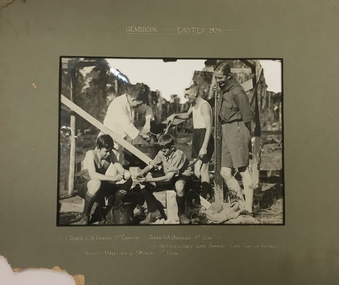
Photograph, 1st Kew Scout Group, 1st Kew Scouts - Gembrook, Easter 1928, 1928
... High Street Kew melbourne The 1st Kew Scouts was one of the first Scout Troops in Victoria, being formed in 1909. From 1927 they met in a magnificent Scout Hall in Disraeli Street, Kew until it was demolished in 1993. Still operating (in 2020) from their new Scout Hall on the corner of Kilby Road ...The 1st Kew Scouts was one of the first Scout Troops in Victoria, being formed in 1909. From 1927 they met in a magnificent Scout Hall in Disraeli Street, Kew until it was demolished in 1993. Still operating (in 2020) from their new Scout Hall on the corner of Kilby Road and Kellett Grove, Kew.1st Kew Scouts with the Governor of Victoria and Chief Scout, Lord Somers. For many years Victorian Scouts participated in a competition camp at the Gilwell Park Scout Camp at Gembrook. The Governor of Victoria has traditionally taken on the honorary role of Victorian Chief Scout and would have been visiting the camp to encourage the Scouts. The names of the Scouts featured in the photograph are inscribed on the mount and include two Rovers, who would have been acting as Scout Leaders on the camp, and two Scouts (who are peeling some spuds for dinner).Front: "Gembrook, Easter, 1928 / Rover C.H. Fraser 1st Croxton, Rover A.A. Drohan 1st Kew / His Excellency Lord Somers Chief Scout of Victoria / Scouts Whelan & Sturdy 1st Kew"scouts - kew, 1st kew scouts, lord somers - governor of victoria, scout camp -
 Kew Historical Society Inc
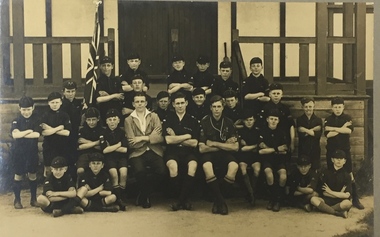
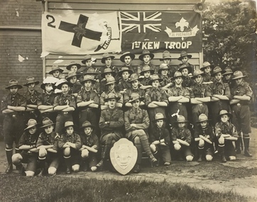
Photograph, 1st Kew Scout Troop with the Cohen Shield, c.1922
... High Street Kew melbourne The 1st Kew Scouts was one of the first Scout Troops in Victoria, being formed in 1909. From 1927 they met in a magnificent Scout Hall in Disraeli Street, Kew until it was demolished in 1993. Still operating (in 2020) from their new Scout Hall on the corner of Kilby Road ...The 1st Kew Scouts was one of the first Scout Troops in Victoria, being formed in 1909. From 1927 they met in a magnificent Scout Hall in Disraeli Street, Kew until it was demolished in 1993. Still operating (in 2020) from their new Scout Hall on the corner of Kilby Road and Kellett Grove, Kew.Large group photo, mounted on card, of 1st Kew Scouts in uniform. The group of thirty-seven Scouts and two leaders (probably R.J. Poewrie SM and R. Wall ASM) are posed with a shield, likely to be the ‘Cohen Shield’, awarded at a statewide Scoutcraft competition for ‘Champion Troop of Victoria’. This was won by 1st Kew in 1922. The building in the photo is not the Disraeli Street Hall, which was a weatherboard construction.1st Kew Troop cohen shield, 1st kew scout troop, kew - scouts -
 Kew Historical Society Inc
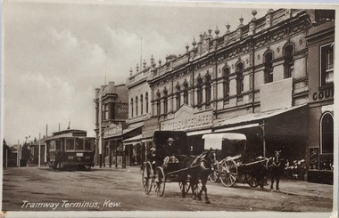
Postcard, Oastler (Leading Stationer), Tramway Terminus, Kew, c.1913
... ...Cotham Road -- high street --- kew (vic.)...However, other postcards produced after this date do not always conform to this print layout. postcards -- kew (vic.) trams -- kew (vic.) Cotham Road -- high street --- kew (vic.) The Block -- Cotham Road -- Kew (vic.) ...The Kew Historical Society's postcard collection includes views of Kew, Melbourne and Greater Melbourne as well as those including overseas scenes sent or received from Europe or the Middle East. They date from the 1890s to the 2000s. These postcards may or may not include the name of the publisher or printer. A number of the cards were published as parts of popular series. A way of dating early postcards is to identify whether the reverse was divided by a central line which became the norm after 1902 in the United Kingdom. However, other postcards produced after this date do not always conform to this print layout.A monochrome postcard of the tram terminus beside 'The Block' in Cotham Road, KewOastler, leading stationer, Kew / Printed in Saxonypostcards -- kew (vic.), trams -- kew (vic.), cotham road -- high street --- kew (vic.), the block -- cotham road -- kew (vic.) -
 Kew Historical Society Inc
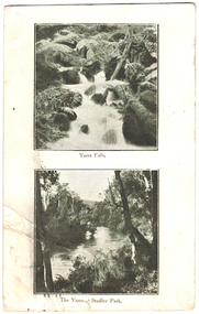
Postcard, Yarra Falls, The Yarra at Studley Park, 1920-1950
... High Street Kew melbourne The Yarra River was a major subject for the producers of postcards in Melbourne. This dual image postcard shows images of the Yarra in two locations. Studley Park in Kew was a major location for recreation activities by the people of Melbourne. Image of the Yarra at Sudley Park shows remnant vegetation preserved on the banks of the Yarra in this part of Kew. yarra falls dual image postcards yarra river -- studley park -- melbourne (vic.) monochrome postcards "Mrs Clark, Harp Road, East Kew / Wishing Mother a very happy Birthday and many returns / from Eileen" Monochrome postcard with two images of the Yarra River, the lower image showing the Yarra at Studley Park. ...The Yarra River was a major subject for the producers of postcards in Melbourne. This dual image postcard shows images of the Yarra in two locations. Studley Park in Kew was a major location for recreation activities by the people of Melbourne.Image of the Yarra at Sudley Park shows remnant vegetation preserved on the banks of the Yarra in this part of Kew.Monochrome postcard with two images of the Yarra River, the lower image showing the Yarra at Studley Park. The reverse has a handwritten birthday greeting from Eileen to her mother Mrs Clark. Original postage stamp has been removed and slight tearing in top right corner. Two ink stamps KEW HISTORICAL SOCIETY have been added."Mrs Clark, Harp Road, East Kew / Wishing Mother a very happy Birthday and many returns / from Eileen"yarra falls, dual image postcards, yarra river -- studley park -- melbourne (vic.), monochrome postcards -
 Kew Historical Society Inc
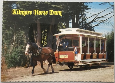
Postcard, The Tramway Museum Society of Victoria Ltd, Kilmore Horse Tram, c.1991
... Kew Historical Society Inc Kew Court House 188 High Street Kew melbourne The Kew Historical Society's postcard collection includes views of Kew, Melbourne and Greater Melbourne as well as those including overseas scenes sent or received from Europe or the Middle East. They date from the 1890s to the 2000s. kilmore horse tram, tramway museum society of victoria, tramways - victoria postcards This replica tram, constructed by members Alan Antcliff and Newton Williams in Mildura represents the open car used between Sydney Road and the Royal Melbourne Zoological Gradens until 1923. ...The Kew Historical Society's postcard collection includes views of Kew, Melbourne and Greater Melbourne as well as those including overseas scenes sent or received from Europe or the Middle East. They date from the 1890s to the 2000s.Modern postcard produced by the Tramway Museum Society of Victoria. The photo is of a replica tram in Victoria's Tramway Museum, and was presumably purchased for display purposes for an exhibition relating to transport in Kew, and in particular to the Kew horse-tram which operated from the Victoria Street Bridge to the Boroondara General Cemetery in Kew.This replica tram, constructed by members Alan Antcliff and Newton Williams in Mildura represents the open car used between Sydney Road and the Royal Melbourne Zoological Gradens until 1923. The open "toast rack" type was use extensively on other horse and early electric tram systems. Photo by William F Scott. Produced by The Tramway Museum of Victoria Ltd Box 4916, Mail Exchange, Melbourne, Victoria, 3001. Operator of Victoria's Tramway Museum, Union Lane, Bylands (55 km from Melbourne off the Northern Highway) Open Sundays 11a.m - 5p.m. CS2036kilmore horse tram, tramway museum society of victoria, tramways - victoria, postcards -
 Kew Historical Society Inc
Postcard, The Tramway Museum Society of Victoria Ltd, Kilmore Horse Tram, c.1991
... Kew Historical Society Inc Kew Court House 188 High Street Kew melbourne The Kew Historical Society's postcard collection includes views of Kew, Melbourne and Greater Melbourne as well as those including overseas scenes sent or received from Europe or the Middle East. They date from the 1890s to the 2000s. kilmore horse tram, tramway museum society of victoria, tramways - victoria postcards This replica tram, constructed by members Alan Antcliff and Newton Williams in Mildura represents the open car used between Sydney Road and the Royal Melbourne Zoological Gradens until 1923. ...The Kew Historical Society's postcard collection includes views of Kew, Melbourne and Greater Melbourne as well as those including overseas scenes sent or received from Europe or the Middle East. They date from the 1890s to the 2000s.Modern postcard produced by the Tramway Museum Society of Victoria. The photo is of a replica tram in Victoria's Tramway Museum, and was presumably purchased for display purposes for an exhibition relating to transport in Kew, and in particular to the Kew horse-tram which operated from the Victoria Street Bridge to the Boroondara General Cemetery in Kew.This replica tram, constructed by members Alan Antcliff and Newton Williams in Mildura represents the open car used between Sydney Road and the Royal Melbourne Zoological Gradens until 1923. The open "toast rack" type was use extensively on other horse and early electric tram systems. Photo by William F Scott. Produced by The Tramway Museum of Victoria Ltd Box 4916, Mail Exchange, Melbourne, Victoria, 3001. Operator of Victoria's Tramway Museum, Union Lane, Bylands (55 km from Melbourne off the Northern Highway) Open Sundays 11a.m - 5p.m. CS2036 kilmore horse tram, tramway museum society of victoria, tramways - victoria, postcards -
 Kew Historical Society Inc
Postcard, Biscay Greetings Pty Ltd, Trams at Kew Depot, c.1991
... The Kew tram depot is located on the corner of Barkers Road and High Street, Kew. It is one of eight tram depots on the Melbourne tram network. ...Kew Historical Society Inc Kew Court House 188 High Street Kew melbourne The Kew tram depot is located on the corner of Barkers Road and High Street, Kew. ...The Kew tram depot is located on the corner of Barkers Road and High Street, Kew. It is one of eight tram depots on the Melbourne tram network. The depot opened on 8 May 1915. The main yard has 12 covered roads. There are two tracks for trams leaving or entering via Barkers Road, and a single track connecting to High Street.Postcard produced c.1991 to commemorate 75 Years of Service of The Kew Depot (1915/16-1991). The postcard shows two trams at the depot. The details are included in the information provided on the reverse.Kew Depot is ready for work W Class 892 waits for its next duty while visiting V Class 214 is ready for special work Photo by R. J. Marsh T101 Copyright Biscay Greetings Pty Ltd Telephone (03) 562 3599tramways - kew, kew tramways depot, -
 Kew Historical Society Inc
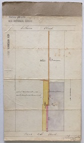
Plan, Survey Plan, Park Hill Road, Kew, 1880-1890
... Kew Historical Society Inc Kew Court House 188 High Street Kew melbourne The streets identified on the survey plan - Cotham Road, Park Hill Road East, Park Hill Road West in Kew were each gazetted by the Victorian Government in 1865. ...The streets identified on the survey plan - Cotham Road, Park Hill Road East, Park Hill Road West in Kew were each gazetted by the Victorian Government in 1865. The hand-coloured survey plan was completed by Holland Loxton, Town Clerk and Surveyor of the Borough of Kew from 1866. The unnamed survey plan includes names of land owners in addition to measurements (2 chains to 1 inch) and streets. Named owners include Webster, Payne and Francom which will enable us to narrow down the creation date of the survey.Handdrawn survey plan by a former surveyor and town clerk of KewHand drawn and coloured survey plan created by Holland Loxton, Surveyor and Town Clerk of Kew, showing land owned by Payne in Park Hill Road, Kew. The plan includes street names, land measurements and land owners.surveys - kew, maps - kew, holland loxton, park hill road - kew, holland loxton -- surveyor, survey plans -- parkhill road -- kew (vic.) -
 Kew Historical Society Inc
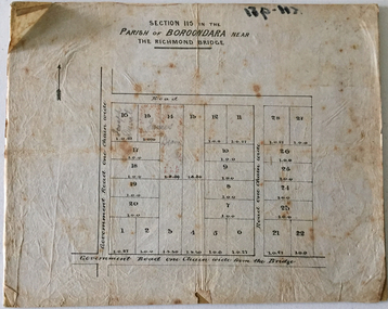
Plan - Subdivision Plan, J Hurrey, Section 115 in the Parish of Boroondara Near Richmond Bridge, 1853
... Kew Historical Society Inc Kew Court House 188 High Street Kew melbourne Despite the plans claims that it is a subdivision near the Richmond Bridge, Section 115 was located at what is now Camberwell Junction. While the plan only lists government roads ...Despite the plans claims that it is a subdivision near the Richmond Bridge, Section 115 was located at what is now Camberwell Junction. While the plan only lists government roads rather than named streets, the section was located on the east side of Burke Road, stretching up the hill from the current Junction. Research on Trove, conducted by Kerry Fairbank, discovered an advertisement for unsold lots in Section 115 which clarifies the extent and location of subsequent land sales in the original section. The original article can be viewed through the link in the catalogue record. The interesting link to Kew is the reference to James Beavan as the purchaser of lots 14 and 15. The historian Gwen McWilliam has notes that a Mr Beavan changed his name from Bevan. The Bevans were descendants of the Derricks family of Kew. This subdivision plan is the earliest original map or plan in the collection which shows parts of what is now the City of Boroondara, dating from circa 1853. It provides important information for researchers on subsequent subdivisions following the original land sales in [Camberwell] Boroondara. The site, on the east side of Burke Road is a highly-significant and historic site. This is believed to be the only extant copy of the subdivision in public collections.A small plan on parchment listing 28 lots, between one and two acres each, for sale in Section 115 in the Parish of Boroondara, dating from 1853 when the portion was subdivided.Obverse: Lot 16 "Joseph Duval", Lots 14 & 15 "James Beavan". Other annotations (measurements) are unreadable. Reverse: "KH-981 / Section 115 in the Parish of Boroondara / Near Richmond Bridge / 1640T. / J Duval / 14-15 J. Beavanparish of boroondara, subdivision plans - camberwell, section 115 - boroondara, subdivision plans -- camberwell (vic), riverscape road, burke road, camberwell junction -
 Kew Historical Society Inc
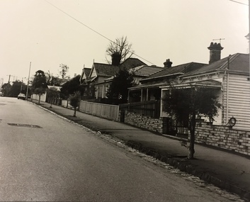
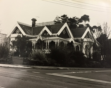
Photograph, City of Kew, Houses, Edgevale Road, Kew, c.1980
... Kew Historical Society Inc Kew Court House 188 High Street Kew melbourne One of a series of photos created for an exhibition by the City of Kew of notable locations. The photos represent a snapshot in time. edgevale road - kew city of kew From Kew City C'cil 10 April 1991 Enlarged photograph of houses on the east side of Edgevale Road between Wellington Street and Cotham Road in Kew, mounted on board, and donated to the Kew Historical Society by the City of Kew on 10 April 1991. ...One of a series of photos created for an exhibition by the City of Kew of notable locations. The photos represent a snapshot in time.Enlarged photograph of houses on the east side of Edgevale Road between Wellington Street and Cotham Road in Kew, mounted on board, and donated to the Kew Historical Society by the City of Kew on 10 April 1991.From Kew City C'cil 10 April 1991edgevale road - kew, city of kew -
 Kew Historical Society Inc
Photograph, City of Kew, 878 Glenferrie Road, Kew, c.1980
... Kew Historical Society Inc Kew Court House 188 High Street Kew melbourne One of a series of photos created for an exhibition by the City of Kew of notable locations. The photos represent a snapshot in time. 878 glenferrie road - kew streetscapes From Kew City C'cil 10 April 1991 Enlarged photograph of 878 Glenferrie Road, Kew, mounted on board, and donated to the Kew Historical Society by the City of Kew on 10 April 1991. ...One of a series of photos created for an exhibition by the City of Kew of notable locations. The photos represent a snapshot in time.Enlarged photograph of 878 Glenferrie Road, Kew, mounted on board, and donated to the Kew Historical Society by the City of Kew on 10 April 1991. The house was extant when checked in August 2017.From Kew City C'cil 10 April 1991878 glenferrie road - kew, streetscapes -
 Kew Historical Society Inc
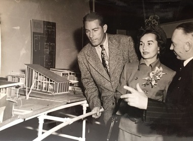
Photograph - Publicity Photograph, Herald Feature Service, Inspection of Architectural Models for a New Kew City Hall, circa 1959, 1959
... High Street Kew melbourne The original Kew Town Hall offices were located in Walpole Street, Kew. Before 1960, even though it had been much discussed over a number of decades, Kew did not have a 'civic hall'. When required, events such as balls, exhibitions or theatrical events were held in the Kew Recreation Hall in Walpole Street. A new City Hall was to be opened by Sir Robert Menzies in 1960. It was located beside the Alexandra Gardens in Cotham Road ...The original Kew Town Hall offices were located in Walpole Street, Kew. Before 1960, even though it had been much discussed over a number of decades, Kew did not have a 'civic hall'. When required, events such as balls, exhibitions or theatrical events were held in the Kew Recreation Hall in Walpole Street. A new City Hall was to be opened by Sir Robert Menzies in 1960. It was located beside the Alexandra Gardens in Cotham Road. It is now used as the Kew Library. Cr Hugh George Ferguson (at right) was born in June 1900 in Williamstown. After his family moved to Kew, they lived in Fernhurst Grove while his future wife’s family lived in Fellows Street. He married in 1940 and subsequently joined the Australian Imperial Forces. After the war he worked as a Billeting Affairs Organiser for the Dutch Government, resettling migrants in Australia. He also worked in advertising as an account manager, and was campaign director for Arthur Rylah is Victorian politics. He organised the first major trade fairs at the Royal Exhibition Buildings after the Second World War, including a World Trade Fair. He built a home in Brougham Street and represented North Ward on Kew Council from 1952 to 1968. He was elected Mayor for the 1959-60 term. He died in 1975, aged 75, and is buried in Boroondara Cemetery.An item of historical interest donated by members of the Dods family in 2006. The Dods-Ferguson Collection includes a number of items once in the possession of the families related to or descended from two mayors of Kew: Cr. Hugh Ferguson and Cr. Frederick Dods.Publicity photograph of two men and a woman inspecting architectural models for a new Kew City Hall. The man at the right of the photograph is Cr Hugh George Ferguson, Mayor of Kew 1959-60. The Hall, now occupied by the Kew Library, was opened by The Hon H.E. Bolte MLA, Premier of Victoria in 1960.Herald Sun Feature Service / Hugh G. Ferguson & Associates / New Kew City Hall. kew city hall, hugh g. ferguson & asociates, architectural models - kew, cr hugh george ferguson -
 Kew Historical Society Inc
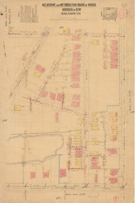
Plan, Melbourne & Metropolitan Board of Works : Borough of Kew : Detail Plan No.1296, 1904
... Road and brick and weatherboard villas in Foley Street. Nearer the pit, weatherboard houses predominated. Foley Street bisected the triangular block and continued right to Denmark Street. At this stage, a house impeded the through road, only allowing access via a right of way to High...Road and brick and weatherboard villas in Foley Street. Nearer the pit, weatherboard houses predominated. Foley Street bisected the triangular block and continued right to Denmark Street. At this stage, a house impeded the through road, only allowing access via a right of way to High ...The Melbourne and Metropolitan Board of Works (MMBW) plans were produced from the 1890s to the 1950s. They were crucial to the design and development of Melbourne's sewerage and drainage system. The plans, at a scale of 40 feet to 1 inch (1:480), provide a detailed historical record of Melbourne streetscapes and environmental features. Each plan covers one or two street blocks (roughly six streets), showing details of buildings, including garden layouts and ownership boundaries, and features such as laneways, drains, bridges, parks, municipal boundaries and other prominent landmarks as they existed at the time each plan was produced. (Source: State Library of Victoria)This plan forms part of a large group of MMBW plans and maps that was donated to the Society by the Mr Poulter, City Engineer of the City of Kew in 1989. Within this collection, thirty-five hand-coloured plans, backed with linen, are of statewide significance as they include annotations that provide details of construction materials used in buildings in the first decade of the 20th century as well as additional information about land ownership and usage. The copies in the Public Record Office Victoria and the State Library of Victoria are monochrome versions which do not denote building materials so that the maps in this collection are invaluable and unique tools for researchers and heritage consultants. A number of the plans are not held in the collection of the State Library of Victoria so they have the additional attribute of rarity.Original survey plan, issued by the MMBW to a contractor with responsibility for constructing sewers in the area identified on the plan within the Borough of Kew. The plan was at some stage hand-coloured, possibly by the contractor, but more likely by officers working in the Engineering Department of the Borough and later Town, then City of Kew. The hand-coloured sections of buildings on the plan were used to denote masonry or brick constructions (pink), weatherboard constructions (yellow), and public buildings (grey). This area was once known as O’Shaughnessy’s Paddock. O’Shaughnessy was the licensee of the Kew Hotel. The ‘Paddock’ or farm was for many years the closest farm to Melbourne. By 1903, when this plan was surveyed and lithographed, little of the farm remained. The area is dominated by a ‘clay hole’, on the site of the current Foley Reserve. It was used by Smart’s Brickyard from the 1880s until 1911, when the Council purchased it for a rubbish dump. It is notable as the site is one of the few industrial operations to have existed in Kew. By 1903, urban development was characterised by larger houses fronting Barkers Road and brick and weatherboard villas in Foley Street. Nearer the pit, weatherboard houses predominated. Foley Street bisected the triangular block and continued right to Denmark Street. At this stage, a house impeded the through road, only allowing access via a right of way to High Street.melbourne and metropolitan board of works, detail plans, mmbw 1296, cartography -
 Kew Historical Society Inc
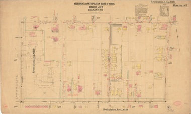
Plan, Melbourne & Metropolitan Board of Works : Borough of Kew : Detail Plan No.1573, 1905
... high-class Christian education for girls, comparable with that provided elsewhere for boys. Some shops are shown along Edgevale Road, though they are not designated as commercial premises. Larger houses are depicted, including ‘Fairlawn’ in Barkers Road, and ‘Clevedon’ and ‘Rosehill’ (now demolished) in Fitzwilliam Street....high-class Christian education for girls, comparable with that provided elsewhere for boys. Some shops are shown along Edgevale Road, though they are not designated as commercial premises. Larger houses are depicted, including ‘Fairlawn’ in Barkers Road, and ‘Clevedon’ and ‘Rosehill’ (now demolished) in Fitzwilliam Street. ...The Melbourne and Metropolitan Board of Works (MMBW) plans were produced from the 1890s to the 1950s. They were crucial to the design and development of Melbourne's sewerage and drainage system. The plans, at a scale of 40 feet to 1 inch (1:480), provide a detailed historical record of Melbourne streetscapes and environmental features. Each plan covers one or two street blocks (roughly six streets), showing details of buildings, including garden layouts and ownership boundaries, and features such as laneways, drains, bridges, parks, municipal boundaries and other prominent landmarks as they existed at the time each plan was produced. (Source: State Library of Victoria)This plan forms part of a large group of MMBW plans and maps that was donated to the Society by the Mr Poulter, City Engineer of the City of Kew in 1989. Within this collection, thirty-five hand-coloured plans, backed with linen, are of statewide significance as they include annotations that provide details of construction materials used in buildings in the first decade of the 20th century as well as additional information about land ownership and usage. The copies in the Public Record Office Victoria and the State Library of Victoria are monochrome versions which do not denote building materials so that the maps in this collection are invaluable and unique tools for researchers and heritage consultants. A number of the plans are not held in the collection of the State Library of Victoria so they have the additional attribute of rarity.Original survey plan, issued by the MMBW to a contractor with responsibility for constructing sewers in the area identified on the plan within the Borough of Kew. The plan was at some stage hand-coloured, possibly by the contractor, but more likely by officers working in the Engineering Department of the Borough and later Town, then City of Kew. The hand-coloured sections of buildings on the plan were used to denote masonry or brick constructions (pink), weatherboard constructions (yellow), and public buildings (grey). This plan has detailed annotations written in red or blue ink, showing prices, which may be the annual valuations of the properties, and some owners’ names, a most unusual feature on contractor's maps. Some areas, such as the buildings of Methodist Ladies’ College (MLC), include the school’s tennis court and swimming pool, but are not coloured to show building materials – did the draftsman just run out of time, or ink, or enthusiasm, before his plan had to be submitted? MLC had been founded in 1882 as a ‘modern school of the first order’ with buildings that formed ‘a collegiate institution for girls unsurpassed in the colonies’. The goal of its founders was to provide a high-class Christian education for girls, comparable with that provided elsewhere for boys. Some shops are shown along Edgevale Road, though they are not designated as commercial premises. Larger houses are depicted, including ‘Fairlawn’ in Barkers Road, and ‘Clevedon’ and ‘Rosehill’ (now demolished) in Fitzwilliam Street.melbourne and metropolitan board of works, detail plans, mmbw 1573, maps - borough of kew, cartography -
 Kew Historical Society Inc
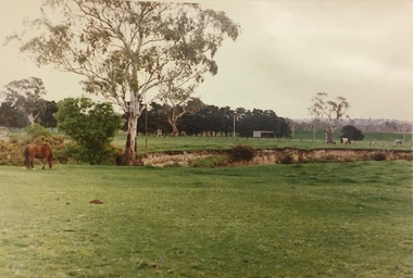
Photograph, Country Roads Board, Hays Paddock, East Kew, 1975
... Kew Historical Society Inc Kew Court House 188 High Street Kew melbourne hays paddock - kew east (vic) parks and gardens - kew (vic) Reverse: "Hays Paddock. Tops of bank to be rounded gently, grassed & planted." Colour photograph of Hays Paddock in East Kew taken by a Country Roads ...Colour photograph of Hays Paddock in East Kew taken by a Country Roads Board photographer. The reverse provides details of the negative and the purpose of the photograph.Reverse: "Hays Paddock. Tops of bank to be rounded gently, grassed & planted."hays paddock - kew east (vic), parks and gardens - kew (vic) -
 Kew Historical Society Inc
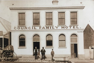
Photograph - Photograph [copy], Council Family Hotel, Cotham Road, circa 1888, c.1888
... High Street Kew melbourne The Council Family Hotel was the fifth of the eight hotels to be licensed in Kew during the 19th Century. They were licensed in the following date order: The Woodman Inn (1854), The Harp of Erin (1854), O’Shaughnessy’s Kew Hotel (1855), the Prospect Hill Hotel (1858), the Council Family Hotel (1861), the Princess Hotel (1864), the Clifton Hotel (1868) and the Greyhound Hotel (1873). Rare photograph of a landmark Kew Hotel hotels - kew council family hotel - kew (vic) Mr Pat Ryan in doorway Exterior - Council Family Hotel, Cotham Road ...The Council Family Hotel was the fifth of the eight hotels to be licensed in Kew during the 19th Century. They were licensed in the following date order: The Woodman Inn (1854), The Harp of Erin (1854), O’Shaughnessy’s Kew Hotel (1855), the Prospect Hill Hotel (1858), the Council Family Hotel (1861), the Princess Hotel (1864), the Clifton Hotel (1868) and the Greyhound Hotel (1873).Rare photograph of a landmark Kew HotelExterior - Council Family Hotel, Cotham Road, Kew, circa 1888.Mr Pat Ryan in doorwayhotels - kew, council family hotel - kew (vic) -
 Kew Historical Society Inc
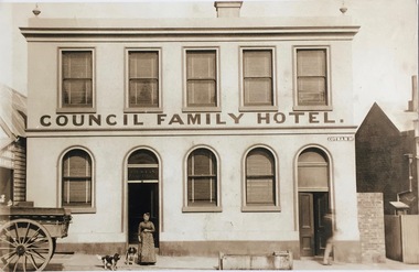
Photograph - Photograph [copy], Council Family Hotel, Cotham Road, circa 1888, c.1888
... High Street Kew melbourne The Council Family Hotel was the fifth of the eight hotels to be licensed in Kew during the 19th Century. They were licensed in the following date order: The Woodman Inn (1854), The Harp of Erin (1854), O’Shaughnessy’s Kew Hotel (1855), the Prospect Hill Hotel (1858), the Council Family Hotel (1861), the Princess Hotel (1864), the Clifton Hotel (1868) and the Greyhound Hotel (1873). Rare photograph of a landmark Kew hotel hotels - kew council family hotel - kew (vic) licenees - ryan family Mrs Ryan Exterior - Council Family Hotel in Cotham Road ...The Council Family Hotel was the fifth of the eight hotels to be licensed in Kew during the 19th Century. They were licensed in the following date order: The Woodman Inn (1854), The Harp of Erin (1854), O’Shaughnessy’s Kew Hotel (1855), the Prospect Hill Hotel (1858), the Council Family Hotel (1861), the Princess Hotel (1864), the Clifton Hotel (1868) and the Greyhound Hotel (1873).Rare photograph of a landmark Kew hotelExterior - Council Family Hotel in Cotham Road, Kew (Vic) with Mrs Ryan, wife of the licensee at frontMrs Ryanhotels - kew, council family hotel - kew (vic), licenees - ryan family