Showing 1835 items matching "rivers in victoria"
-
 Albert Park-South Melbourne Rowing Club
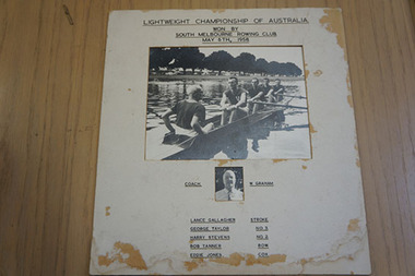
Photograph of South Melbourne Rowing Club Crew that Won the First Championship for Lightweight Fours (Penrith Cup), 1958, 1958
... was taken on the Yarra River, Victoria, prior to the Regatta ..."As with most items in the AP-SMRC collection, the ‘chain of ownership’ is not formally recorded for this item. The image is not unique, but is one of a set that was produced for each of the men represented in the photographs, with perhaps additional copies for the SMRC. Lance Gallagher, speaking with Ms (Grace) Blake and the consultant (Mrs Margaret Birtley) on 8 June 2014, recalled the photograph well and confirmed on 17 July 2014 that he has a personal copy." 2014 Significance Assessment, p28."This item comprises two photographs mounted together with a caption that identifies the men depicted as being a South Melbourne Rowing Club (SMRC) crew and coach. Representing Victoria, this crew won the first Championship for Lightweight Fours at an Interstate Regatta. The race was contested on the Nepean River, NSW, on 3 May 1958. The photograph of the crew was taken on the Yarra River, Victoria, prior to the Regatta and was used for publicity in the Regatta program.16 The victory was significant to SMRC because the oarsmen and coaches (although not the coxswain) were members of that club. The item is a memento of the club’s success, through its crew, at an elite and national level. The Lightweight Four Championship event’s first hosting at Penrith on the Nepean River resulted in a perpetual trophy being donated by that local municipal council. The race for the Lightweight Championship Four continues to this day as a featured event at the annual Interstate Regatta. The Penrith Cup lends its name to this prestigious event. It is unusual for Interstate race crews to be drawn entirely from a single club; more typically, the state representative crews are selected as composites. The selection of an all-SMRC crew for this inaugural race between representative Lightweight Four crews testifies to the exceptional standards at SMRC during this period. The item is of historic significance because it provides pictorial evidence of the crew and the club’s success in a national competition and in a category of event that was being contested at the Interstate Regatta for the very first time. It also carries social significance through the captioning that credits the victory as being the club’s rather than the state’s, and thus reflects the pride of the SMRC in the achievements of its oarsmen and coaches." 2014 Statement of Significance, p30Unframed photograph of the crew which won the inaugural interstate men’s lightweight coxed four in Penrith, 1958. Lightweight Championship of Australia / Won by / South Melbourne Rowing Club / May 6th, 1958 Coach W. Graham / Lance Gallagher Stroke / George Taylor No. 3 / Harry Stevens No. 2 / Bob Tanner Bow / Eddie Jones Cox / South Melbourne state crew ??? This event became the Penrith Cup.rowing, albert park lake, apsm rowing club, penrith cup, lightweight, four, championship, south melbourne rowing club, gallagher, lance, taylor, george, stevens, harry, tanner, bob, jones, eddie, webster, jack, graham, wal -
 Albert Park-South Melbourne Rowing Club
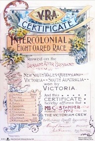
Certificate, Handasyde and Goldsworthy, V.R.A Certificate / Intercolonial Eight-Oared Race, 1900
A colour certificate given to the winners of the 1900 Intercolonial Eight-Oared Race. Rowed on the BRISBANE RIVER, BRISBANE / 12th May, 1900 / BETWEEN THE COLONIES OF / NEW SOUTH WALES - QUEENSLAND -- / VICTORIA -- SOUTH AUSTRALIA -- / won by / VICTORIA / J. DONALD Stroke / T. DAVIES No. 7 / H.J. HUGHES …6 / A. HALL …5 / A. DAWSON …4 / J. COCKBILL ...3 / C. STAMPER ...2 / J. SUFFREN ...Bow / J. COUNIHAN Cox / J.M. MACFARLANE Honorary Coach / And this / CERTIFICATE / hereby affirms that / C. STAMPER / rowed No. 2 in / THE VICTORIAN CREW. / For Victorian Rowing Association / (Signature) President / (Signature) Hon. Secretary -
 Federation University Art Collection
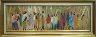
Painting - Artwork - Painting, 'Procession Along the Todd River' by Wesley Pemberthy
Wesley PEMBERTHY (1920- ) Born Broken Hill, New South Wales Wesley Pemberthy spent his childhood in Adelaide, South Australia. As an adult he lived in Bendigo, Ballarat, Clunes, Creswick, Daylesford and Perth. While in Perth he studied at Perth Technical School (1933-1937), followed by studies under the tutorship of Norman Lindsay in New South Wales (1938-1941). After service during World War Two Wes Pemberthy became the first Rehabilitation student at the National Gallery School, Victoria, undertaking research into the techniques of the Old Masters. He was the winner of the Sulman Award in 1955. The Sulman Prize is awarded for the best subject painting, genre painting or mural project by an Australian artist.Framed painting showing a number of brightly dressed people in a treed landscape. artists, artwork, wes pemberthy, wesley pemberthy, aborigines, aboriginal -
 Vision Australia
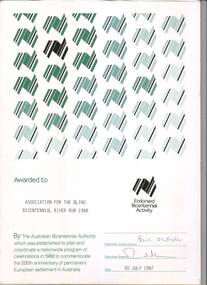
Certificate - Text, Association for the Blind: Bicentennial River Run 1988, 1987
Certificate reads "Awarded to Association for the Blind Bicentennial River Run 1988. By the Australian Bicentennial Authority which was established to plan and coordinate a nationwide program of celebrations in 1988 to commemorate the 200th anniversary of permanent European settlement in Australia" Signed by the Chairman: Victoria Council (illegible) and Executive Director (illegible), dated 30th July 1987. All text on this certificate is located on the bottom half of the document. The top half is populated by a repeated stylised graphic of a map of Australia, in various shades of green and gold. There is also a gold version of the same logo, labelled with "Endorsed Bicentennial Activity" , situated above the official signatures. 1 certificate with Australia imageryassociation for the blind, awards -
 Port Fairy Historical Society Museum and Archives
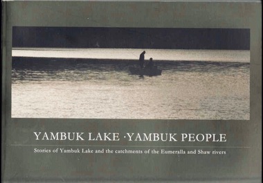
Book, Glenelg-Hopkins Catchment Management Authority, Yambuk Lake Yambuk people : stories of Yambuk Lake and the catchments of Eumeralla and Shaw Rivers, 2008
This title explores the complex relationships between the people and the place of Yambuk; the value of local knowledge and tells the stories of the Yambuk Lake, wetlands, rivers and catchment. Historic records and photographs are combined with the recollections of more than 20 people who know the lake.vi, 207 pages : colour illustrations, maps. ; 21 x 30 cm. Includes bibliographic references. non-fictionThis title explores the complex relationships between the people and the place of Yambuk; the value of local knowledge and tells the stories of the Yambuk Lake, wetlands, rivers and catchment. Historic records and photographs are combined with the recollections of more than 20 people who know the lake.baxter, annie maria, 1816-1905., water quality management -- victoria -- yambuk lake., settlement and contacts - settlers., animals - fish - eels., gunditjmara / gurndidy / dhaurwurd-wurrung people (s20) (vic sj54-11), yambuk (vic.) -- social conditions., yambuk (vic.) -- history., yambuk lake (vic.), yambuk (w vic sj54-11), deen maar / lady julia percy island (w vic sj54-11), eumeralla (w vic sj54-11), peek wurrung people, book -
 University of Melbourne, Burnley Campus Archives
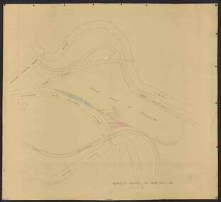
Plan, Department of Public Works, Burnley School of Horticulture, c.1951
Department of Public Works, Melbourne, Victoria plan No. 51/66 of extension of grounds. Area bounded by Yarra River to north and south. Additional areas coloured. Position of new buildings and new house shown.burnley school of horticulture -
 University of Melbourne, Burnley Campus Archives
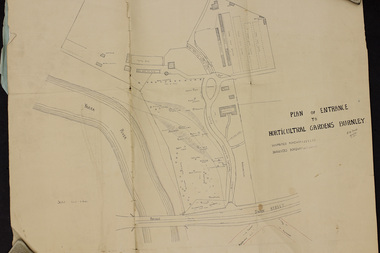
Plan, Plan of Entrance to Horticultural Gardens Burnley, 1932
Copy of plan photographed at the Public Records Office Victoria. (1) Hand drawn plan signed by A.W. Jessep 8/12/32 with 'Suspected Roadway' and ' Suggested Roadway'. Scale 1 inch - 1 chain. Trees on East side named. (2) Memorandum to The Agricultural Superintendent dated 08.12.1932 'Re Proposed Boulevard Along the River Yarra' from the Principal A.W. Jessep. Plan had been to put road through the Lagoon Paddock and he suggested the route outside the Burnley College grounds.prov, burnley gardens, a.w. jessep -
 Falls Creek Historical Society
Photograph - Ray Meyer at Blair's Hut
MEYER COLLECTION - FALLS CREEK PHOTOS In 1947 a determined group of like-minded State Electricity Commission (SEC) staff including Ray Meyer, the chief surveyor of the Kiewa Hydro-Electric Scheme, had a common interest that revolved around the skiing potential of the snow-covered high plains which included what is now the resort of Falls Creek. The six SEC employees, Toni St Elmo, Ray Meyer, Jack Minogue, Lloyd Dunn, Adrian Ruffenacht and Dave Gibson (together with their families) banded together to secretly build a 'hut' that was the first ski lodge at Falls Creek. Using a road built in 1930s to gain access to Falls Creek, their hut project was carried out in secret as efforts by other skiers were blocked by H.H.C. Williams – the engineer in charge of the Hydro Scheme. In 1946 Ray Meyer made a trip to the Lands Office in Melbourne. He came away with a 99-year lease on three acres that was ideally suited for a hut designed by Lloyd Dunn. Adrian Ruffenacht (Design Engineer for the KHS) had suggested where the group should build because of easy access to a spring for water. Much of the building material required was scavenged from derelict huts on the high plains. Due to the need for secrecy, the determined group worked on the hut in the evenings and weekends to avoid detection. During the building period the group had met at Echidna Rock (now known as Eagle Rock) where Skippy St Elmo announced, "This is my favourite ‘Skyline’.” And so the first lodge in the area at Falls Creek Ski Resort came into existence. With the development of the International Poma in the 1970s, the Skyline Lodge, which was sited between the ski-lift’s pole one and pole two, was demolished. However, the legacy of Ray Meyer, Toni St Elmo, Jack Minogue, Lloyd Dunn, Adrian Ruffenacht and Dave Gibson and Skyline lives on in the vibrant atmosphere of Falls Creek Resort. The MEYER COLLECTION documents developments on the Kiewa Hydro Scheme and their life at Falls Creek from the mid 1930s to 1960s.This image is significant because it documents the activities of a prominent family in Falls Creek, VictoriaA photo of Ray Meyer at the Kiewa River near Blairs Hut. The original hut, built by cattlemen Frank and Tim Blair in 1923-24, was burnt down around 193o. It was rebuilt by Frank and his son in 1932. It is constructed of Alpine Ash.ray meyer, blairs hut, falls creek, victorian snowfields -
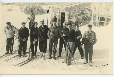
 Falls Creek Historical Society
Photograph - Bogong Trip 1951- At Cleve Cole Lodge
MEYER COLLECTION - FALLS CREEK PHOTOS In 1947 a determined group of like-minded State Electricity Commission (SEC) staff including Ray Meyer, the chief surveyor of the Kiewa Hydro-Electric Scheme, had a common interest that revolved around the skiing potential of the snow-covered high plains which included what is now the resort of Falls Creek. The six SEC employees, Toni St Elmo, Ray Meyer, Jack Minogue, Lloyd Dunn, Adrian Ruffenacht and Dave Gibson (together with their families) banded together to secretly build a 'hut' that was the first ski lodge at Falls Creek. Using a road built in 1930s to gain access to Falls Creek, their hut project was carried out in secret as efforts by other skiers were blocked by H.H.C. Williams – the engineer in charge of the Hydro Scheme. In 1946 Ray Meyer made a trip to the Lands Office in Melbourne. He came away with a 99-year lease on three acres that was ideally suited for a hut designed by Lloyd Dunn. Adrian Ruffenacht (Design Engineer for the KHS) had suggested where the group should build because of easy access to a spring for water. Much of the building material required was scavenged from derelict huts on the high plains. Due to the need for secrecy, the determined group worked on the hut in the evenings and weekends to avoid detection. During the building period the group had met at Echidna Rock (now known as Eagle Rock) where Skippy St Elmo announced, "This is my favourite ‘Skyline’.” And so the first lodge in the area at Falls Creek Ski Resort came into existence. With the development of the International Poma in the 1970s, the Skyline Lodge, which was sited between the ski-lift’s pole one and pole two, was demolished. However, the legacy of Ray Meyer, Toni St Elmo, Jack Minogue, Lloyd Dunn, Adrian Ruffenacht and Dave Gibson and Skyline lives on in the vibrant atmosphere of Falls Creek Resort. The MEYER COLLECTION documents developments on the Kiewa Hydro Scheme and their life at Falls Creek from the mid 1930s to 1960s.This image is significant because it depicts aspects of the life of a pioneering family of Falls Creek and the founders of "Skyline", the first lodge at Falls Creek.Black and White Images of visitors at Cleve Cole Lodge. Photo 1. L to R:- Ray Meyer, H. Gibbs and Wal Johnson. Photo 2. Ray Meyer and Wal Johnson having photo taken. CLEVE COLE HUT was built in 1937 for the Ski Club of Victoria, to commemorate pioneer skier, Cleve Cole, who died on a disastrous ski trip across the high In August 1936 three men, Cleve Cole, Mick Hull, and Howard Michell, skied from Mount Hotham across the Bogong High Plains to Mount. On reaching the mountain they became trapped for four days on the summit ridge by appalling weather conditions. For three days they followed the Big River through rough country before deciding that Howard should continue alone to find help, leaving Mick to care for Cleve who was barely able to continue. Three days later a search party, raised after Howard had reached Glen Valley, found Cleve and Mick. Within two days the group arrived at Glen Valley where, tragically, Cleve Cole died later that night. In memory of Cleve’s life and his pioneering work in the Victorian alpine country it was decided to build a refuge hut on the mountain. It is called the Cleve Cole Memorial Hut.falls creek, bogong high plains, cleve cole hut -
 Falls Creek Historical Society
Photograph - Bogong Trip 1951- Outside Cleve Cole Hut
MEYER COLLECTION - FALLS CREEK PHOTOS In 1947 a determined group of like-minded State Electricity Commission (SEC) staff including Ray Meyer, the chief surveyor of the Kiewa Hydro-Electric Scheme, had a common interest that revolved around the skiing potential of the snow-covered high plains which included what is now the resort of Falls Creek. The six SEC employees, Toni St Elmo, Ray Meyer, Jack Minogue, Lloyd Dunn, Adrian Ruffenacht and Dave Gibson (together with their families) banded together to secretly build a 'hut' that was the first ski lodge at Falls Creek. Using a road built in 1930s to gain access to Falls Creek, their hut project was carried out in secret as efforts by other skiers were blocked by H.H.C. Williams – the engineer in charge of the Hydro Scheme. In 1946 Ray Meyer made a trip to the Lands Office in Melbourne. He came away with a 99-year lease on three acres that was ideally suited for a hut designed by Lloyd Dunn. Adrian Ruffenacht (Design Engineer for the KHS) had suggested where the group should build because of easy access to a spring for water. Much of the building material required was scavenged from derelict huts on the high plains. Due to the need for secrecy, the determined group worked on the hut in the evenings and weekends to avoid detection. During the building period the group had met at Echidna Rock (now known as Eagle Rock) where Skippy St Elmo announced, "This is my favourite ‘Skyline’.” And so the first lodge in the area at Falls Creek Ski Resort came into existence. With the development of the International Poma in the 1970s, the Skyline Lodge, which was sited between the ski-lift’s pole one and pole two, was demolished. However, the legacy of Ray Meyer, Toni St Elmo, Jack Minogue, Lloyd Dunn, Adrian Ruffenacht and Dave Gibson and Skyline lives on in the vibrant atmosphere of Falls Creek Resort. The MEYER COLLECTION documents developments on the Kiewa Hydro Scheme and their life at Falls Creek from the mid 1930s to 1960s.This image is significant because it depicts aspects of the life of a pioneering family of Falls Creek and the founders of "Skyline", the first lodge at Falls Creek.Black and White Images taken at Cleve Cole Hut Photo 1 Outside Cleve Cole 1951 - From Left: Ray Meyer, Wal Johnson and other people from a visiting group Photo 2 Cleve Cole Hut Mt. Bogong CLEVE COLE HUT was built in 1937 for the Ski Club of Victoria, to commemorate pioneer skier, Cleve Cole, who died on a disastrous ski trip across the high In August 1936 three men, Cleve Cole, Mick Hull, and Howard Michell, skied from Mount Hotham across the Bogong High Plains to Mount. On reaching the mountain they became trapped for four days on the summit ridge by appalling weather conditions. For three days they followed the Big River through rough country before deciding that Howard should continue alone to find help, leaving Mick to care for Cleve who was barely able to continue. Three days later a search party, raised after Howard had reached Glen Valley, found Cleve and Mick. Within two days the group arrived at Glen Valley where, tragically, Cleve Cole died later that night. In memory of Cleve’s life and his pioneering work in the Victorian alpine country it was decided to build a refuge hut on the mountain. It is called the Cleve Cole Memorial Hut.falls creek, bogong high plains, ray meyer, cleve cole hut -
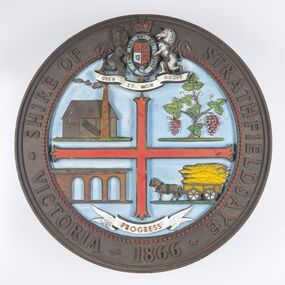 City of Greater Bendigo - Civic Collection
Sign - Shire of Strathfieldsaye Coat of Arms
The district of Strathfieldsaye was proclaimed in 1861 and named a Shire on the 17th September in 1866. It remained a shire until amalgamation in 1994 when it became part of the City of Greater Bendigo. The shire was located 8 km to the south- east of Bendigo and covered an area of 601 square kilometres and extended from the Calder Highway to the Coliban and Campaspe Rivers. The shire's administration centre was in Strathfieldsaye until 1972 when new offices were opened in Kennington. This coat of arms was commissioned for the front of the shire hall building.Brass painted coat of arms or emblem within a circle of the Shire of Strathfieldsaye. Outer rim contains text: SHIRE OF STRATHFIELDSAYE VICTORIA 1866 with the shield of the monarch of the United Kingdom centre top. The shield is divided into four parts with images reflecting the leading industries of the time; wine growing, mining, farming and tanning. The motto PROGRESS is depicted lower centre of shield. SHIRE OF STRATHFIELDSAYE / VICTORIA / 1866 / PROGRESSshire of strathfieldsaye, city of greater bendigo amalgamation, city of greater bendigo signs -
 Melton City Libraries
Newspaper, Melbourne A.A. Club, 1903
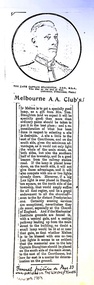
"Captain Simon Thomas Staughton was the son of Simon Thomas Staughton MLA who had built the mansion Eynesbury on his share of the Exford property inherited from his father Simon Staughton, the original 1840s Werribee River squatter. When the land was sold, Simon’s Exford station extended from Mt Cotterell to the Brisbane Ranges. ST Staughton (senior) was a reputedly the public spirited member of the family in his generation, being a member of the first Roads Board (and Melton Shire President in 1867), a JP, Magistrate and MLA for Bourke from 1883 until his death in 1901, whereupon his son became the MLA for Bourke. Captain ST Staughton had earlier been chosen as a member of a contingent of Victorian Mounted Riflemen sent to England for Queen Victoria’s Diamond Jubilee (1897), and was later a member of King Edward’s coronation escort. In October 1899 he had sailed for South Africa with other Mounted Riflemen from Victorian and NSW to take part in the Boer War. There he was awarded the DSO. He died of peritonitis in 1903, aged 27. He was buried in Boroondara Cemetery after a full military funeral, in which the coffin was borne on a gun carriage drawn by four black horses. All local newspapers reported eloquently on the funeral, and the late Captain’s virtues. The Staughton Memorial Lamp was given to the town by his young widow in 1903. In addition a window in the (former) Christ Church bore the inscription ‘This window is erected by his brother soldiers in loving memory of Captain S Tom Staughton, DSO, ADC, MLA’. The Staughton family had been prominent benefactors of the Church, whose altar rails were also inscribed to the much respected Captain, along with a memorial stone in the new chancel. In the 1970s the memorial was within one of four fenced tree plantations, probably erected and planted in the 1920s or 30s. When High Street and its service roads were redesigned in the 1970s the plantations were completely removed, and the Melton and District Historical Society was successful in having the memorial moved about 50 metres east to its present location". The Weekly Times article about a gift from Tom Staughtonlocal identities -
 Melbourne Legacy
Slide, Operation Firewood - Red Gum Forest, Murray River, 1960s
Colour slide of red gum trees in a forest near the Murray River. It was during Operation Firewood. Legatees would organise collection of wood from the country and distribute it to widows in metropolitan Melbourne. More photos show the cutting and loading of wood and delivery to widows in metropolitan Melbourne. Was with many other slides taken in the 1950s and 1960s. The slides have been photographed to make digital images and moved to archive quality sleeves. In many cases the original images were not well focussed and the digital image the best available.A record of Legacy helping widows by sourcing, supplying and delivering firewood. When open fires were the main source of heating, a load of firewood and help moving it, would have been very important to the widows.Colour slide of trees in a Red Gum forest during Operation Firewood in brown Anscochrome cardboard mount. Printed on reverse in red ink 'Processed by Verycolor photo labs. Melbourne, Victoria'.Printed on front in red ink 'Anscochrome / View from this side / Made in Australia'. Hand written on front 'Red gum trees / River Murry' in blue pen.operation firewood, trees, forest -
 Melbourne Legacy
Slide, Operation Firewood - Eildon Reservoir, 1960s
Colour slide of a view of Lake Eildon from Big River Road. It was during Operation Firewood. Legatees would organise collection of wood from the country and distribute it to widows in metropolitan Melbourne. Other slides show the cutting and loading of wood and delivery to widows in metropolitan Melbourne. Was with many other slides taken in the 1950s and 1960s. The slides have been photographed to make digital images and moved to archive quality sleeves. In many cases the original images were not well focussed and the digital image the best available.A record of Legacy helping widows by sourcing, supplying and delivering firewood. When open fires were the main source of heating, a load of firewood and help moving it, would have been very important to the widows.Colour slide of a view of Lake Eildon during Operation Firewood in brown Anscochrome cardboard mount.Printed on front in red ink 'Anscochrome / View from this side / Made in Australia'. Hand written on front 'Eildon Reservoir from Big River Road' in blue pen. Printed on reverse in red ink 'Processed by Verycolor photo labs. Melbourne, Victoria'.operation firewood, trees, forest -
 Canterbury History Group
Book, Richard Broome, Remembering Melbourne 1850-1960, 2016
A book of over 700 black and white illustrations and photographs of early Melbourne scenes, mainly buildings, which have been demolished or significantly changed. The first half of the book concentrates on the CBD but includes public gardens and the Yarra River. The second half of the book looks at a number of the inner suburbs including Footscray.Large red covered book with black and white dust cover featuring panoramic view of Princes Bridge looking North. 366 pages : photographs, 1 map, portraits. Includes bibliographical references and indexnon-fictionA book of over 700 black and white illustrations and photographs of early Melbourne scenes, mainly buildings, which have been demolished or significantly changed. The first half of the book concentrates on the CBD but includes public gardens and the Yarra River. The second half of the book looks at a number of the inner suburbs including Footscray.historical buildings - melbourne, melbourne - history, canterbury - history -
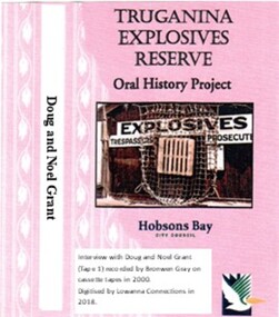 Truganina Explosives Reserve Preservation Society Inc (TERPS)
Digitised Oral History – Truganina Explosives Reserve - Tape 1 Doug and Noel Grant, 2018
The interviews were recorded in 2000 by Bronwen Gray and Alan Young for the production of Unreserved, Stories from Truganina Explosives Reserve, animated stories from past residents, workers and interested people of the Reserve (subject to copyright 2004). Doug and Noel Grant’s Grandfather, Don Grant, was officer in charge of Truganina Explosives Reserve from 1910-1930. On his retirement, his son, William (known as Bill) took over the position until 1956. Along with their two older brothers and younger sister, Doug and Noel Grant grew up, first in the assistant manager’s weatherboard cottage and then in the brick house which was set aside for the officer in charge, until they married and moved into their own homes in their early 1920s. On returning from the second world war, Noel Grant worked as a magazine assistant of explosives on the site from 1946, When the site had closed down in 1962 he worked as an inspector of explosives at the Explosives Branch in Melbourne until he retired in 1985. During that time Noel was asked to move back on site, meaning that three generations of Grants have lived on the site during the twentieth century. Doug Grant worked for ICI/Nobel in head office in 1940 and their older brother Alan worked at the Nobel Explosive Company in Deer Park from 1937. After returning from the Second World War, Alan bought a transport business that had once had the licence to cart explosives in and around the state. They discuss their memories of the living at Truganina Explosives Reserve and the workings of the Reserve, including the names of men who worked there, ships which carried the explosives and life in and around Altona. A primary source of information on memories of the Truganina Explosives Reserve and Altona,VictoriaDigital copy of original cassette recorded in 2000 and digitised in 2018hobsons bay, altona, galvanised iron fence, picket fence, golf course, altona school, margaret grant, bill grant, explosives magazine, lighters, joe hyde, alex grant, pines scout camp, maribynong river, 1896, inspector of explosives, pier, point wilson, werribee sewerage farm, george grant, lighterman, huia, argonaut, pirie, alma doepel, merton street altona, horse, jessie grant, jean grant, sandal, kilmartin, lewis, currie, todd, robinson, balwyn -
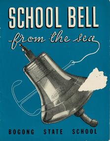 Falls Creek Historical Society
Booklet - School Bell from the sea - Bogong State School
This booklet tells the story of the bell from the "S. S. Santhia" and how it came to Bogong State School, Victoria. "Santhia" belonged to the British India Line. On 6th November 1943 she was in service as a troopship when she caught fire and capsized at No. 3 Garden Reach Jetty, Calcutta. Due to the additional weight of water pumped into her to extinguish the fire, "Santhia" heeled over and remained in the mud of the River Hooghly until a successful salvage was completed in January 1946. The salvage operation was carried out by Captain J. P. Williams of Melbourne and his team of Australian divers nine and a half months after the commencement of operations. "Santhia" was the sixty seventh ship salvaged by Captain Williams. "Santhia's" Bell was presented by Captain Williams to Mr G.G. Jobbins, Chairman of Commissioners for installation at Bogong State School. The ceremony of presenting the bell took place on 21st February 1947. The bell bears the following inscription:- "Presented to G.G.Jobbins, Esq., Chairman, State Electricity Commission, by Captain J.P. Williams for Bogong School, on December 6th, 1946. This bell was recovered from the wreck of the "S.S.Santhia" sunk in the Hooghly River, Calcutta, and raised by an Australian salvage party."This booklet is significant because it documents an unusual event linking Bogong State School to a World War II salvage operation.A booklet consisting of images and text which tells the story of S.S. Santhia, of her sinking while in service as a troopship, of her subsequent salvage and how her bell came to Bogong State School in Victoria's High Country. The booklet consists of 12 pages including the cover. It consists of text and images. Primarily printed in black and white, the booklet uses blue boxes to highlight text including titles and explanation of images. The cover is blue with white text and features an image of the bell of the S. S. Santhia.Inside front cover: THIS BOOKLET is presented by THE STATE ELECTRICITY COMMISSION OF VICTORIA to the children of BOGONG STATE SCHOOLbogong state school, s.s.santhia, santhia bell -
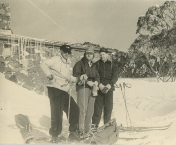
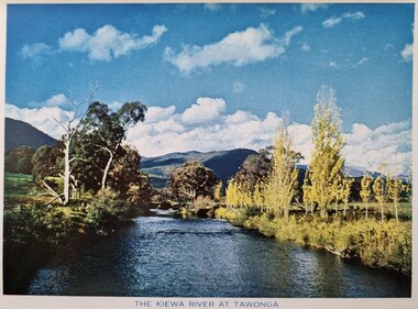 Falls Creek Historical Society
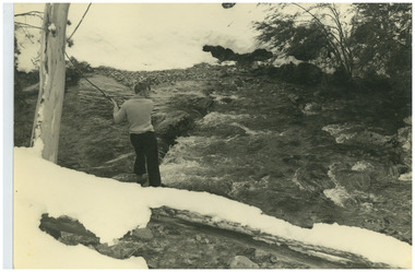
Postcard - The Kiewa River at Tawonga
These photographs were taken in and around Falls Creek by Samuel Keith Pearce and printed for him as a foldout postcard by NuColor Vue. The postcards state they were printed for S. K. Pearce Pty. Ltd of Tawonga and Mount Beauty. Samuel Keith Pearce was born on 24 June 1917 in Armadale, Victoria. By the late 1940s he owned the Mt Beauty Supermarket, Newsagency, Drapery and Hardware store at Mount Beauty and also a store at Tawonga in partnership with his brother Gordon Cathew Pearce. For some time, they operated as Pearce Brothers. In the early 1960s Keith also opened a mini mart In Falls Creek. As well as being a keen photographer and an astute businessman, Keith Pearce was a well-known identity in the Kiewa Valley, making many contributions to the development of the area over a long period. This included serving as a member of the Bright Shire Council for many years. He worked hard to promote the interests of the Upper Kiewa Valley. As a sign of recognition and appreciation for his contribution to the community, the park opposite the grocery store in Mount Beauty was named the SK Pearce Gardens in his honour. Samuel Keith Pearce died on 7 July 1994 in Mount Beauty, Victoria.This collection of postcards and images is significant because they were commissioned by a highly successful businessman in Falls Creek, Victoria.A colour image of the Kiewa River at Tawonga with mountains in the background. S. K Pearce had a business in Tawonga and established other stores at Mount Beauty and Falls Creek.falls creek, falls creek chairlifts, poma lift falls creek -
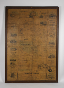 Bacchus Marsh & District Historical Society
Map, The Unique Advertising Combine, The Unique Combine's New Map of the Shire of Bacchus Marsh, 1890
This map was one of a number of similar maps produced for advertising purposes by a company called, 'The Unique Advertising Combine'. The company was located in Melbourne on Queens Walk. A brief item in the Bacchus Marsh Express newspaper on 29 March 1890 , page 2, indicated that subscribers to the Bacchus Marsh Express could obtain a copy of this map in the next issue of that newspaper. On the map is the detail that it was compiled by W.H. Bonney from official records supplied by D. A. Little, hire Secretary, (of Bacchus Marsh Shire).This map with its accompanying illustrations of local businesses and shops in Bacchus Marsh is an important documentary and visual snapshot of the town and district of Bacchus Marsh in the later part of the nineteenth century. The illustrations for some of the local businesses are the only known visual record of those particular buildings. The map is a rare surviving example of the material produced by The Unique Advertising Combine. Another similar example for the Shire of Mornington is held by the State Library of Victoria,A map of the Shire of Bacchus Marsh produced in March 1890. The map is mounted on a board and enclosed within a timber frame. The map includes an inset detail section showing the central part of the township of Bacchus Marsh including the main shopping and business streets. Land holdings with the first European land holders names indicated are included on the map. Rivers, creeks, major roads and the railway line are also shown on the map. Around the edges of the map are illustrated advertisements mostly for Bacchus Marsh businesses but which also includes some businesses located in Melbourne. maps bacchus marsh shire, shops bacchus marsh -
The 5th/6th Battalion Royal Victoria Regiment Historical Collection
Print - Book, Miracle on the River Kwai
River KwaiWhite cover - black & green writingMiracle on the River Kwai5/6 rvr, officer's / sergeant's mess -
!['Save Fairfield Hospital' badge, [1990s]](/media/collectors/5bb42dc221eaf31100db1d3b/items/5c9af03221ea720f88da88fb/item-media/5c9af03f21ea720f88daaa65/item-fit-380x285.jpg) Australian Nursing & Midwifery Federation
Australian Nursing & Midwifery Federation'Save Fairfield Hospital' badge, [1990s]
Fairfield Hospital opened in 1904 as the Queen's Memorial Infectious Diseases Hospital, the first purpose-built isolation hospital for infectious diseases in Victoria. Its 22-acre site was located on a bank of the Yarra River. It was renamed Fairfield Hospital in 1948. In its later years, the hospital was a centre for AIDS treatment in Victoria, and a passionate campaign fought against its planned closure in the 1990s. Fairfield Hospital finally closed in June 1996. One section of the site was gazetted as a Public Park and Memorial Garden (containing an AIDS Garden).Circular white and red plastic badge. Silver metal, plastic-coated, with safety pin fastener adhered to back. Badge printed with the red text 'SAVE FAIRFIELD HOSPITAL'. Silver metal, plastic-coated, with safety pin fastener adhered to back.medicine, health, public institutions, fairfield, victoria, city of darebin, melbourne, politics, political protest, public protest, campaigning, badges, buttons, pins, public health, infectious diseases, aids -
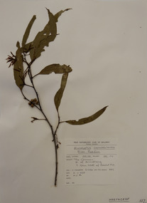 Federation University Herbarium
Plant specimen, Alexander Clifford Beauglehole, Eucalyptus camaldulensis Dehnh
Cliff Beauglehole was an orchardist at Portland, Victoria, who throughout hislife took an intense interest in the plants of Victoria. Over his lifetime he collected 90,000 plant specimens as part of a comprehensive study of Victoria's plants and wrote thirteen books under the heading The Distribution and Conservation of Vascular Plants in Victoria, each written to cover the 13 study areas of the Victorian and Conservation Council.A mounted botanical specimen.beauglehole herbarium, herbarium specimen, botany, herbarium, plant science, plant specimen, field naturalists' club ballarat, federation university herbarium, eucalyptus camaldulensis, river red gum, myrtaceae -
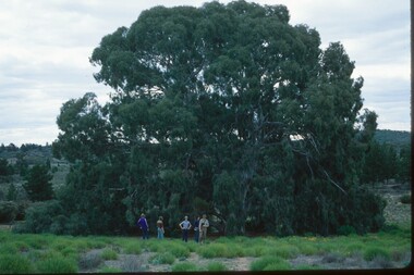 Mordialloc College Alumni Association Inc (MCAA)
Photograph, 1979 Wyperfeld Old Be-al River Red Gum Tree, 1979
1979 - Mordialloc-Chelsea High School students standing in front of “Old Be-al” in Victoria’s Wyperfeld National Park, near Outlet Creek. It has been described as one of the most magnificent River Red Gums in the land. This glorious tree with foliage hanging to the ground escaped the fire of 1959 but not the fire of 1982 that damaged it badly. It lives on but has also suffered from lack of water and is now inaccessible to the public in a reference area. The MCAA has provided this image to the Friends of Wyperfeld National Park. Mordialloc-Chelsea High School students visited the Wyperfeld National park annually for the biology and geography Year 11 school camp.Example of a River Red Gum at Wyperfeld National Park.Digital image reproduced from colour slide.big desert fire 1959, mordialloc-chelsea high school camp, wyperfeld national park, fire 1982, old be-al river red gum -
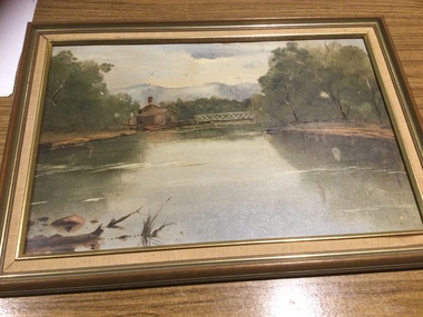 Mont De Lancey
Painting
... Original painting of Heidelberg, Victoria by Margaret... Original painting of Heidelberg, Victoria by Margaret Quayle. River ...Hand painted by Margaret Quayle.Original painting of Heidelberg, Victoria by Margaret Quayle. River scene with house and bridge, in a wooden frame.paintings, artworks -
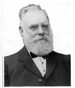 Tarnagulla History Archive
Photograph of John Shields Simpson, circa 1880s
Murray Comrie Collection. Information written by Murray Comrie: John Shields Simpson was born in Scotland in 1831, came to Victoria in 1853 and after mining for a time took up land at what was later to be the Nick O'Time Lead at Poseidon. He took up a store at Newbridge and in 1905 built a hotel alongside the store. Both were severely damaged in floods of the Loddon River in 1909. He was elected to the Tarnagulla Borough Council in 1882 and retained his seat until 1915 when he resigned. He was Mayor of the Borough on five occasions. Monochrome photographic portrait of a bearded man.Accompanying note identifies subject as John Shields Simpson.borough of tarnagulla, john shields simpson, mayor, council, local government, local people, newbridge, store, hotel -
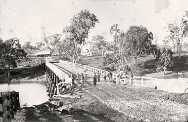 Tarnagulla History Archive
Photograph of the newly completed bridge at Newbridge, Victoria, c.1894, The newly completed bridge at Newbridge, Victoria, c.1894, 1894
Murray Comrie Collection. This photograph is a well-preserved original. Monochrome photograph depicting the newly completed wooden bridge at Newbridge, Victoria. Thirteen men are in the image, standing at one end of the bridge. These are most likely men who worked on constructing the bridge. Position of photographer is on the west bank of the Loddon, looking east.newbridge, bridge, loddon river, infrastructure, construction, roads, workers, farms, people -
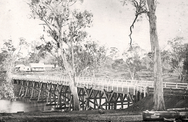 Tarnagulla History Archive
Photograph of the newly completed bridge at Newbridge, Victoria, c.1894, The newly completed bridge at Newbridge, Victoria, c.1894, 1894
Murray Comrie Collection. This photograph is a well-preserved original. Monochrome photograph depicting the newly completed wooden bridge at Newbridge, Victoria. Position of photographer is on the east bank of the Loddon, looking west toward the present day Newbridge Pub.newbridge, bridge, loddon river, infrastructure, construction, roads, businesses, buildings -
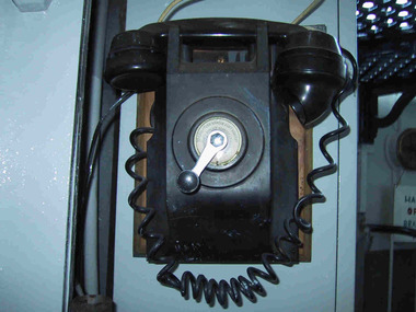 Parks Victoria - Point Hicks Lightstation
Telephones
The lightstation was connected by telephone to Cann River in 1928. The lighthouse retains ablack Bakelite telephone attached to the lantern room wall on timber box mount. It has a crank handle with instructions for its use on the crank dial, and a coiled handset cord, which probably dates the phone to just after 1949 when coiled examples like these began to replace fabric covered smooth cords. An image in 1991 shows the phone in the lower level of the lantern room It is one of four telephones at the lightstsation; with two others attached to walls in the assistant keepers’ quarters, and one in the head keeper’s quarters. The four phones formed an intercom system that facilitated communication between the lightstation buildings. Three telephones of the same wall-mounted, crank dial type remain at Gabo Island Lightstation; four remain at Cape Otway and five older examples remain at Cape Nelson Lightstation As fixtures attached to the wall, the four telephones are considered to be part of the building fabric and therefore included in the existing Victorian Heritage Register listing for the lightstation (VHR 1983).As fixtures attached to the wall, the four telephones are considered to be part of the building fabric and therefore included in the existing VHR listing for the lightstation (VHR 1983).Four telephones with a crank handle mounted on a wooden base, one is fixed to the wall of the lantern room and is black bakelite. Yes -
 Melton City Libraries
Photograph, Exford, Unknown
1867 President (Road Board), Shire President. 1856 coach house – skillion dairy. First two storey house in rural Victoria 1842. Rammed earth Shearers quarters Exford Homestead on Werribee River (formerly Exe River) Home of Simon Staughton, arrived 1841 local identities, pioneer families -
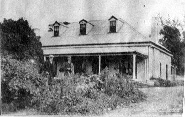
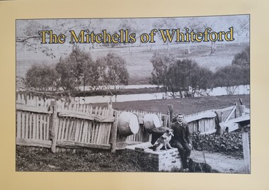 Wodonga & District Historical Society Inc
Book - The Mitchells of Whiteford, Paul Mitchell, 2020
"Whiteford is a mystical place. A small farm in north-east Victoria, rising from the rich flats of the Mitta Mitta River a few kilometres upstream from its confluence with the mighty Murray River. Taken up in 1879 from the large Bethanga run, Whiteford was home to the Mitchell family until it was flooded by the Hume Weir around 1934. Through this collection of family photos and small stories, we might glimpse something of family and farming in the fertile Mitta Mitta Valley before it was flooded by the Hume Weir" - Paul Mitchell, author.A family history of the Mitchell family of Whiteford, Victoria. This publication includes stories and many black and white images of the Mitchell family and their home."Whiteford is a mystical place. A small farm in north-east Victoria, rising from the rich flats of the Mitta Mitta River a few kilometres upstream from its confluence with the mighty Murray River. Taken up in 1879 from the large Bethanga run, Whiteford was home to the Mitchell family until it was flooded by the Hume Weir around 1934. Through this collection of family photos and small stories, we might glimpse something of family and farming in the fertile Mitta Mitta Valley before it was flooded by the Hume Weir" - Paul Mitchell, author.mitta mitta history, mitchell family history, whiteford mitta mitta valley