Showing 65077 items matching "henderson-house"
-
 Box Hill Historical Society
Photograph - Houses - Strabane Avenue, Simon Fox, 1/12/1994
Triple fronted brick residence at Strabane Avenue, Box Hill North. In recent years prior to 1994, Box Hill Council purchased five properties throughout the City for use by residents. This one is the Box Hill North Neighbourhood house. A wide range of activities including playgroups, craft activities and meetings are held here. See page 27 "The days we remember"strabane avenue, box hill north, city of box hill, neighbourhood houses, houses -
 Melton City Libraries
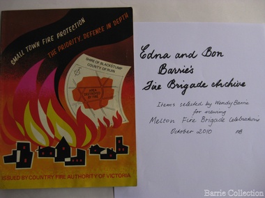
Archive, Edna and Bon Barries Fire Brigade Archives, 2010
In the 1950s with the introduction two-way HF and later VHF very high frequency radio sets. Melton Rural Fire Brigade was part of the Bacchus Marsh Group. Radio sets where located in the Melton Fire Truck, and in the house of the Barrie family at Ferris Road. This was an ideal location to observe a 360 degree view in all directions when smoke appeared on the horizon. An antenna was erected beside the house. The set OX 7 was located in the kitchen and monitored 24 hours by the family. When an electrical fire occurred at the junction of the electricity to the house there was time to radio the fire station and summons the men working in the paddocks, thus saving the house from possible destruction. With the introduction of UHF – ultra high frequency Vinten Radios the signal was clearer and static and interference lessened and radio traffic became easier to read, and reduced noise levels in the household. VL3 LY Radio Base became the Group Headquarters was established in 1967. By 1970 the Brigades were: Melton, Rockbank, Sydenham, Toolern Vale, Diggers Rest, Truganina, and Werribee. In 1974 when the family moved to First Avenue, another antenna and a small building were erected adjacent to the residence and used to house the equipment, maps. Radio traffic consisted of regular schedule times and communication with adjoining groups of brigades such as Bacchus Marsh, Mt Macedon and Little River Groups. Many of the brigade and group base radios were situated in private residences and operated primarily by fire fighters wives who held the position of Communications Officer, either registered as a brigade member or informally. Edna was never registered as an operational brigade member but operated informally as an assistant to her husband Bon. She was however a member of the Melton Fire Brigade Ladies Auxiliary from its inception in 1968, a non-operational position. Edna kept up to date with radio procedure following the 1967 handbook; preparing maps, plotting compass points and taking notes on weather forecasts from the SA Border and Western District. Daily notes were taken in anticipation of fire warnings. These log books and daily radio traffic were incidental to the regular radio schedules. Emergency turnouts noted, burning off times and predicted location of smoke. In the summer fire season all TBF (total fire ban days were recorded.) In times of emergency the Barrie family assisted Bon the base radio operator to plot the position and location of fire trucks and to help clarify garbled radio traffic, keep notes and make telephone calls. These log books are held in the EE and EW Family Archive. Items selected by Wendy Barrie for viewing Melton Fire Brigade celebrationsemergency services, local identities -
 Bendigo Historical Society Inc.
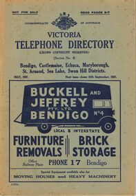
Book - BOOK - MAY 1937. VICTORIA TELEPHONE DIRECTORY
A copy of the Victoria Telephone Directory which is dated in May 1937. It features the telephone numbers for Bendigo, Castlemaine, Echuca, St. Arnaud, Sea Lakes, Swan hill Districts. The front cover also features an ad for the Bendigo moving Business Buckell and Jeffry which has a picture of a black truck with its back open and has the text "Buckell and Jeffry PTY. LTD BENDIGO Local & Interstate FURNITURE, BRICK REMOVALS, STORAGE, Office Railway Place PHONE 17 Bendigo, Special Equipment available also for MOVING HOUSES and HEAVY MACHINERY" The back cover also features two ads, one for the Hotel Ritz which details "Country Visitors to Melbourne will find the HOTEL RITZ, FITZROY STREET ST. KILDA, Conveniently situated to Beaches (3 minutes) and City (10 minutes). Electric Trams pass the door. equipped with Central heating. Hot and Cold water and House Phone in every Bedroom. Luxuriously Furnished. Execellent Cuisine. The Ritz offers the Finest in Hotel Accommodation." and the other ad for the Colonial Scale Repair Co. in Melbournebook, rural -
 Ballarat Tramway Museum
Document - Photocopy, Ballarat Tramway Museum (BTM), "Cottage to go for bypass", "Fun tram just the ticket", 1991
1099.1 - photocopy of an article in The Courier, Ballarat Tuesday Feb. 9 1988, page 17 of the house that contained Ballarat ESCo tram No. 12 in the Tuesday Heritage Column of the newspaper. Contains a photograph of the house containing the tramcar. Newspaper Clipping details the former occupiers, the Rayner family, the construction of the extensions around the tramcar, family use, family history and some details of the family members and other local history. The copy of the newspaper Clipping has numerous pin holes in the corner and the rust marks due to use on a display on Tram No. 12 in a display board in the depot from about 1991 to 1998. From a copy made from the newspaper Clipping collection held by Alan Bradley. 1099.2 - copy made March 1999 of the same Clipping for record purposes and to have a good copy. (2 copies held). Also has a review by John Hindle of the "Storming St. Kilda by Tram", presented by TheatreWorks aboard a special tram for St. Kilda, from the Herald Newspaper dated 15/3/1988. Collected by Alan Bradley.trams, tramways, nerrina, rayner family, theatre, esco -
 Ballarat Tramway Museum
Postcard - Folder set, Colorscans Richmond, "Ballarat Botanic Gardens and Lake Wendouree", c1980
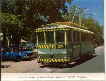
Set of ten colour photos with title photo of Begonias, in a strip suitable for posting in an envelope of views of the Ballarat Botanic Gardens and Lake Wendouree. Made by Colorscans of 123 Dover St. Richmond. Folded so that they form a group that could be posted in a standard envelope. Has a note on the area on a small folding strip at the top. On the inside of the strip: 1. Statue Pomona and Begonia House in the Botanic Gardens 2. The Sarah George Ferry on Lake Wendouree 3. Lake Lodge at dusk 4. Adam Lindsay Gordon's Cottage, Botanic Gardens 5. The Prime Ministers Avenue, Botanic Gardens On the rear 1. Title photo set with Begonias in the Botanic Gardens 2. Vintage tram on the Botanic Gardens Tourist Tramway (No. 27 - in SEC colour scheme with Tram Rides sign). 3. Benzonis 'Flight from Pompeii' 4. Wishing Well in the Botanic Gardens 5. Black swans on the Lake 6. The Mosaic crown at the Shell House (By C.A. Pickford) Photographs by George Hurdes. See Tram 27 repainted by Museum to a different colour scheme in 1983/84. trams, tramways, lake wendouree, wendouree parade, botanical gardens -
 Kew Historical Society Inc
Plan, Melbourne & Metropolitan Board of Works : Borough of Kew : Detail Plan No.1350, 1910
The Melbourne and Metropolitan Board of Works (MMBW) plans were produced from the 1890s to the 1950s. They were crucial to the design and development of Melbourne's sewerage and drainage system. The plans, at a scale of 40 feet to 1 inch (1:480), provide a detailed historical record of Melbourne streetscapes and environmental features. Each plan covers one or two street blocks (roughly six streets), showing details of buildings, including garden layouts and ownership boundaries, and features such as laneways, drains, bridges, parks, municipal boundaries and other prominent landmarks as they existed at the time each plan was produced. (Source: State Library of Victoria). This plan forms part of a large group of MMBW plans and maps that was donated to the Society by the Mr Poulter, City Engineer of the City of Kew in 1989. Within this collection, thirty-five hand-coloured plans, backed with linen, are of statewide significance as they include annotations that provide details of construction materials used in buildings in the first decade of the 20th century as well as additional information about land ownership and usage. The copies in the Public Record Office Victoria and the State Library of Victoria are monochrome versions which do not denote building materials so that the maps in this collection are invaluable and unique tools for researchers and heritage consultants. A number of the plans are not held in the collection of the State Library of Victoria so they have the additional attribute of rarity.Original survey plan, issued by the MMBW to a contractor with responsibility for constructing sewers in the area identified on the plan within the Borough of Kew. The plan was at some stage hand-coloured, possibly by the contractor, but more likely by officers working in the Engineering Department of the Borough and later Town, then City of Kew. The hand-coloured sections of buildings on the plan were used to denote masonry or brick constructions (pink), weatherboard constructions (yellow), and public buildings (grey). MMBW Plan No. 1350 depicts the western end of Studley Park on the north side of the Studley Park Road. ‘Raheen’, then the home of Sir Henry Wrixon is named, the plan identifying those parts of the house that were built of brick and timber. The two houses between Raheen and the River Yarra are also shown. Other parts of the plan show neighbouring streets: Yarra Street, Studley Park Avenue, Studley Street and Fenwick Street. Each, apart from Fenwick Street was subsequently renamed. At the corner of Fenwick and Stawell Streets, the home of Joseph Butterworth Coombs, later called ‘Hope Mansell’, is represented but unnamed.melbourne and metropolitan board of works, detail plans, mmbw 1350, cartography -
 Warrnambool and District Historical Society Inc.
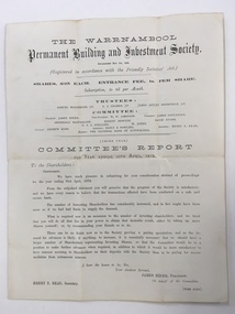
Balance Sheet, Warrnambool Permanent Building and Investment Society 1872, 1872
The Warrnambool permanent Building and Investment Society was established in May 1869. It relied on investors buying shares in the society, thereby providing the funds which were available to be borrowed to use in the building of houses. A considerable number of houses in Warrnambool would have been built using this scheme. The stated trustees in 1872 were Samuel Macgregor, C A Cramer, James Astley Bromfield, and the committee comprised of James Hider, W. W. Jamieson, James Coulstock, Archibald MacFarlane, Robert Newton, David Evans, NT C Stelling and W Jones. The bankers were the national Bank of Australasia. It had some difficulties in the 1870’s but was still operating well into the 1930’s where it again was not putting through the volume of business compatible with its resources and it had been found necessary to pay off a considerable number of fixed deposits and Investors’ shares. There is little mention of it after the mid 1930’s. This document provides details of an organization which operated in Warrnambool for over 60 years and proved beneficial to homebuilders and investors alike. It also has a number of well- known local names listed in their positions of operating the building society.Cream watermarked paper folded to four pages. Title on front cover with letter to shareholders printed below for the year ending 30th April 1872. Page three has balance sheet of the Warrnambool Permanent Building & investment Society. Second and fourth pages are blank. Signed in print by James Hider President, Henry T Read secretary.warrnambool permanent building and investment society, warrnambool, warrnambool 1872, -
Eltham District Historical Society Inc
Document - Folder, Macklin, Isaac, Elizabeth and family
Isaac Macklin and Elizabeth (nee Bailey) Macklin, born Wiltshire UK. Isaac died Tallangatta 1889, Elizabeth died Beechworth 1869. Children of Isaac and Elizabeth: Elizabeth born Eltham ~1846, died Mulwala NSW 1931. Ellen born Little Eltham 1856, married Thomas House, Albury, 26 September 1874, died Coonamble 1914. Children of Thomas and Ellen: Mary, Jane, Emma, Elizabeth Solway, Alice, Thomas, Samuel, Ellen, Martha. Contents Letter Valda McPherson to Eltham District Historical Society, 2 August 2006, providing some information about Elizabeth Macklin, and seeking more information about her. Letter Ruth Lewis to Eltham District Historical Society,, 7 September 2010, providing some information about Isaac and Elizabeth Macklin, and seeking information about their daughter Ellen and her husband Thomas House.Newspaper clippings, A4 photocopies, etcisaac macklin, elizabeth macklin nee bailey, ellen house nee macklin, thomas house, jane house, emma house, elizabeth solway house, alice house, samuel house, ellen house, martha house -
 Glen Eira Historical Society
Photograph, Dalny Road, 5-17 Rear, Murrumbeena, 2001
Originally labelled "Beauville Estate, Established 1936, Still Thriving 65 years on, 10th March 2001", the Beauville Estate Album contains colour photographs of houses in the Estate. They were taken around the time of the Beauville Estate’s 65th Heritage Celebration held on 10/03/2001 and donated to the Caulfield Historical Society shortly afterwards. Photographer unknown. From Glen Eira’s Heritage Management Plan by Andrew Ward (1996) Vol 2 p78: "Beauville Avenue is unusual in that it is terminated in a cul-de-sac (see Section 3.9.2) whilst the design of the estate may well be unique for its time in that the houses back onto 6 tennis courts for public use. St. Patrick's Church, which adjoins the estate is a comparatively recent structure whilst the school has one building erected in 1930 and prior to the release of the Beauville lots." It also notes that St.Patrick's Church and School now run the tennis courts. The Beauville Historic Area is important at the State level as the first large housing estate undertaken by the AV Jennings Construction Co, later Jennings Group Limited, Victoria’s largest home builder. It is important also as a very early estate development incorporating a range of features other than houses and including made roads, shops and recreation facilities. In this respect it was the forerunner of the comprehensively planned housing estate of the post war era. The estate is distinguished by its aesthetic values, as is the earlier and comparable Hillcrest Estate, which are formed by a combination of restrained diversity in house styles, with the exception of no. 30 in the emerging International style, and by a landscaped garden environment. See Significance Statement in Glen Eira’s Heritage Management Plan by Andrew Ward (1996) Vol 2 p.79. Available from https://www.gleneira.vic.gov.au/media/4779/heritage_management_plan_volume_2.pdf (Note see p.84 of pdf)Colour photograph of a playground on the Beauville Estate. murrumbeena, houses, 1930's, a.v. jennings, av jennings, jennings, beauville estate, playgrounds, parks and reserves, sir albert victor jennings, a v jennings construction co, beauville estate heritage area, glen eira city council, jennings group limited, land subdivision, gardens, beauville historic area, st patrick's church, st patrick's school, dalny road -
 Glen Eira Historical Society
Photograph, Dalny Road, 5-17 Rear, Murrumbeena, 2001
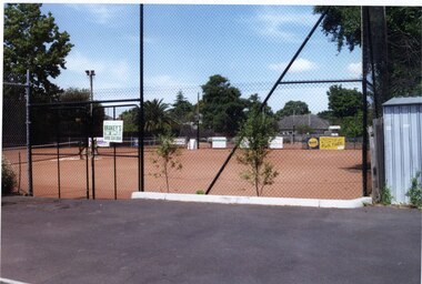
Originally labelled "Beauville Estate, Established 1936, Still Thriving 65 years on, 10th March 2001", the Beauville Estate Album contains colour photographs of houses in the Estate. They were taken around the time of the Beauville Estate’s 65th Heritage Celebration held on 10/03/2001 and donated to the Caulfield Historical Society shortly afterwards. Photographer unknown. From Glen Eira’s Heritage Management Plan by Andrew Ward (1996) Vol 2 p78: "Beauville Avenue is unusual in that it is terminated in a cul-de-sac (see Section 3.9.2) whilst the design of the estate may well be unique for its time in that the houses back onto 6 tennis courts for public use. St. Patrick's Church, which adjoins the estate is a comparatively recent structure whilst the school has one building erected in 1930 and prior to the release of the Beauville lots." It also notes that St.Patrick's Church and School now run the tennis courts.City of Glen Eira’s Heritage Management Plan Vol 2 p79 (this is p84 of the pdf version) – HO12 Beauville Estate and environs, Murrumbeena: The Beauville Historic Area is important at the State level as the first large housing estate undertaken by the AV Jennings Construction Co, later Jennings Group Limited, Victoria’s largest home builder. It is important also as a very early estate development incorporating a range of features other than houses and including made roads, shops and recreation facilities. In this respect it was the forerunner of the comprehensively planned housing estate of the post war era. The estate is distinguished by its aesthetic values, as is the earlier and comparable Hillcrest Estate, which are formed by a combination of restrained diversity in house styles, with the exception of no. 30 in the emerging International style, and by a landscaped garden environment. Colour photograph of tennis courts and surrounding mesh fencing on the Beauville Estate. murrumbeena, houses, 1930's, a.v. jennings, av jennings, jennings, beauville estate, parks and reserves, sports and recreations establishments, tennis courts, sportsgrounds, sir albert victor jennings, a v jennings construction co, beauville estate heritage area, glen eira city council, architectural features, jennings group limited, land subdivision, gardens, beauville historic area, tennis clubs, beauville tennis courts, st patrick's tennis club, dalny road -
 Glen Eira Historical Society
Photograph, Dalny Road, 5-17 Rear, Murrumbeena, 2001
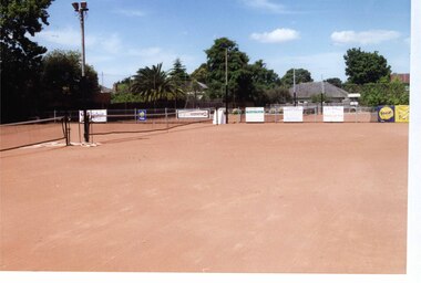
Originally labelled "Beauville Estate, Established 1936, Still Thriving 65 years on, 10th March 2001", the Beauville Estate Album contains colour photographs of houses in the Estate. They were taken around the time of the Beauville Estate’s 65th Heritage Celebration held on 10/03/2001 and donated to the Caulfield Historical Society shortly afterwards. Photographer unknown. From Glen Eira’s Heritage Management Plan by Andrew Ward (1996) Vol 2 p78: "Beauville Avenue is unusual in that it is terminated in a cul-de-sac (see Section 3.9.2) whilst the design of the estate may well be unique for its time in that the houses back onto 6 tennis courts for public use. St. Patrick's Church, which adjoins the estate is a comparatively recent structure whilst the school has one building erected in 1930 and prior to the release of the Beauville lots." It also notes that St.Patrick's Church and School now run the tennis courts. City of Glen Eira’s Heritage Management Plan Vol 2 p79 (this is p84 of the pdf version) – HO12 Beauville Estate and environs, Murrumbeena: The Beauville Historic Area is important at the State level as the first large housing estate undertaken by the AV Jennings Construction Co, later Jennings Group Limited, Victoria’s largest home builder. It is important also as a very early estate development incorporating a range of features other than houses and including made roads, shops and recreation facilities. In this respect it was the forerunner of the comprehensively planned housing estate of the post war era. The estate is distinguished by its aesthetic values, as is the earlier and comparable Hillcrest Estate, which are formed by a combination of restrained diversity in house styles, with the exception of no. 30 in the emerging International style, and by a landscaped garden environment. Colour photograph of tennis courts with lights on the Beauville Estate. murrumbeena, houses, 1930's, a.v. jennings, av jennings, jennings, beauville estate, parks and reserves, sports and recreations establishments, tennis courts, sportsgrounds, sir albert victor jennings, a v jennings construction co, beauville estate heritage area, glen eira city council, architectural features, jennings group limited, land subdivision, gardens, beauville historic area, tennis clubs, beauville tennis courts, st patrick's tennis club, dalny road -
 Robin Boyd Foundation
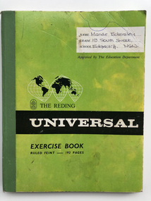
Book - Exercise Book, Mandie Eckersley (nee Boyd), c. 1967
Robin Boyd’s desk cupboard contained two exercise books (D482.1-D482.2) and assorted articles, essays and other material regarding Sydney Opera House (P1378.01-P1378.36, D179-D181, D479-D480), inserted inside the front cover of Walkabout Magazine July 1966 (P1377). Robin Boyd asked Mandie Eckersley (nee Boyd), his eldest daughter, to research the Sydney Opera House for him in the Mitchell Library, both before and after Utzon left. Robin was writing a book, but was very disillusioned with the way the entire saga unfolded. Mandie Boyd recalls: “It was a huge task because he wanted any mention at all in any publications to be noted. No one else had done it at that stage, not even the clippings service.” This second (and final) volume is filled with transcriptions on newspaper articles, editorials and letters to the editor covering the period 1962 to 1966 when Utzon quits. The Reding Universal Exercise Book, filled to pp 0-48 and p 92Written on front cover: "Mandie Eckersley, 19 South Street, Edgecliff. NSW." In exercise book: handwritten notes. On back cover: list of dates from 1966-1977. Inserts in page 41: Public Library of New South Wales photocopying service receipts dated 8-2-67. Public Library of New South Wales Applications slips for books from stack.sydney opera house, jorn utzon, sydney opera house project -
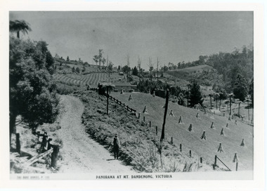 Mt Dandenong & District Historical Society Inc.
Photograph, View From Corner of Doughty's Road and Barbers Road 1913
John Lundy-Clarke grew up in the Kalorama/Mt Dandenong area and later in life (1972-74) began to write a comprehensive history of the area working from an original settlement map in an effort to cover all areas. Taken c1913, this photograph gives a clear indication of where significant buildings were located in relation to one another. Barbers Road is running through the picture with the guest house 'Kia-Ora' , built by George Barber in the centre. High on the skyline on the left is the 'Mountjoy' guesthouse, indicating the location of The Gap, or FiveWays. The small 'boxy' house above 'Kia-Ora' is 'Iona' built by the Paynter family who also built 'Mountjoy'. The Jeeves property 'Kalorama' is to the right of 'Iona' and this is the area you now look to from the FiveWays Lookout. The man in the photo is wearing a trilby hat so is probably a Rose Series employee - a feature in many Rose Series postcards.Black and white photograph that is a copy of Rose Series Postcard # 156. A man can be seen walking down an unmade road with haystacks to his right. Buildings and crops can be seen on the hillsides. Handwritten inscription on reverse by John Lundy-ClarkeView from corner of Doughty’s and Barbers Road 1913. “Kia Ora” in centre Paynter’s “Iona” near center skyline above “Kia Ora” with “Kalorama” on its right and Peter’s hut of the time below it among orchard trees. “Mountjoy” is on left skyline. W. Haye’s home is centre left. Hay paddock is Barbers Lot 25 Village Settlement.kia-ora, iona, kalorama, mountjoy, guesthouse, guest house, barbers road, doughty's road, paynter, jeeves, george barber -
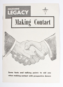 Melbourne Legacy
Booklet, Making Contact. Some facts and talking points to aid you when making contact with prospective donors, 1962
Booklet published for Melbourne Legacy to assist Legatees launch the new Endowment Scheme Campaign Oct 25,1962. A new campaign by Melbourne Legacy to assist Legatees with facts and talking points to aid Legatees when making contact with prospective donors. Sections of the booklet include: Our aim in education; Health is watched; Physical and cultural; Career guidance; Legacy Residences; Holidays and camps; Legal assistance, and Free Firewood. The Health section mentions: "a permanent dental clinic at Legacy House". The Education section mentions: "promising children are helped and encourages to carry their education right through University". The Career section says: "No Legacy child is sent into a dead-end job". The Residences section says: "Three homes - homes in the real sense of the word - are maintained by Legacy in Kew for Legacy children. They are Blamey House, Harelands and Stanhope, the first two owned by Legacy and the last leased free from the Red Cross, in return for its maintenance and upkeep."The booklet gives Legatees the facts and reasons why a potential donor should donate to Legacy. A good snapshot of Legacy's work in the 1960s.Black and white printed, 8 page booklet.Handshake on the front cover. Legacy badge top RH corner.fundraising, legacy promotion -
 Vision Australia
Administrative record - Text, 75th Annual Report 1970 Association for the Blind of Victoria, 1971
Articles in annual report include: branch committees, President's report, finance report, balance sheet, hospital homes, blind citizens community centre, welfare, auxiliaries, senior staff, life governors, historical and current photographs of Ballarat, Bendigo, Brighton and the Blind Citizens Community centre, establishment of an ophthalmological clinic at Elanora, demand for more nursing beds and funding for nursing support, need for hostel accommodation for short stay or respite for carers, renaming of Brighton Blind Home to Elanora, 20 bed nursing wing to be opened at Mirridong next year, a second block of flats facing Glenferrie Road has been purchased due to demand for expansion at Kooyong Blind Citizens Community Centre, plan for a memorial garden with a sensory section in front of the club house, appointment of a hairdresser at Kooyong and two holidays at Cumberland House in Lorne have been organised and were a huge success1 volume of text and photographsassociation for the blind, elanora home (brighton), mirridong home (bendigo), kelaston home (ballarat), annual reports -
 Vision Australia
Administrative record - Text, "Seeing Eye" 1987 Lady Nell "Seeing Eye" Dog School & Rehabilitation Centre for the Blind, 1987
President's overview of the year including: completion of reception room which joins 16 and 18 Thanet Street, thoughts on the success of the school, attendance at International Dog Guide Conference in London, over 27 years the school has trained over 800 dogs, deaths of Jack Franks and Thelma McKenniariey, assisted actor Robert Menzies portray a blind character in the movie 'Cactus', difficulties in running the hostel and day centre with few qualified people to fill vacancies for the former and lack of volunteer drivers for the latter, decision to close Cairns shop, resignation of Kevin O'Mahoney and difficulties in replacing him, long cane training in Queensland, demand for guest speakers, thank you to work experience students, welcome to Ray Owens, presentation of Anzac Award by Lt Governor at Government House, beginning of in-house breeding program - rather that rely on donations of suitable puppies - with Roz McNaught, Alf Krummel and Dawn Robinson providing and housing these dogs.1 volume with text and illustrationsannual reports, lady nell seeing eye dog school, phyllis gration -
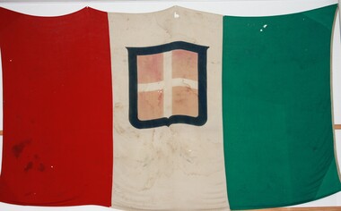 Terang RSL Sub-branch
Flag - Civil flag of the Kingdom of Italy, Circa 1940
The flag of Sardinia was adopted as the official flag of the newly formed Kingdom of Italy in 1861. The flag incorporates the armorial bearings of the Royal House of Savoy, the family who ruled Italy until it voted to become a republic in 1948. Civil flag of the Kingdom of Italy featuring three vertical panels of green (hoist) white and red cotton, sewn together. Sewn into each side of the centre (white) panel is a representation of the coat of arms of the House of Savoy - a blue-bordered red square, quartered by a white cross. This flag would later become the flag of the Kingdom of Italy, and the tricolor without the Savoyard escutcheon remains the flag of Italy. The exact date of the creation of this flag is uncertain, however as it was in use in Italy until the formal establishment of the Italian Republic, it may have been made between 1848 and 1946. This particular flag was brought back at the conclusion of WWII and donated to the Terang RSL Sub-branch.The Civil flag of the Kingdom of Italy is comprised of a red, white and green vertical cotton panels, which have been stitched together by cotton. Each panel is approximately 915 cm wide by 1.610 metres high. The centre panel has an appliquéd Savoy shield, with a centred white cross on red background, surrounded by a blue shield shaped border. -
 Eltham District Historical Society Inc
Audio - Audio Recording, Audio Recording; AGM and Guest Speaker Jane Woollard about Laughing Waters Road, 14 Apr 2016
April Meeting (Newsletter No. 227, Apr. 2016) At this meeting we are pleased to have as our guest speaker Jane Woollard, who has just published a book titled ‘Laughing Waters Road: Art, Landscape and Memory in Eltham.’ Jane was the local history officer at the Shire of Nillumbik so has a detailed knowledge of the history of our area. She has an extensive background as a writer, theatre director and teacher. As well as directing over 50 productions Jane has been a tutor and guest director at the Victorian College of the Arts and La Trobe University and was Artistic Director of the Union House Theatre at the University of Melbourne. Since 2001 more than eighty artists have been in residence at Laughing Waters in Birrarung House and Riverbend. In her book Jane has woven together their experiences and art making, together with Wurundjeri, European and family histories to create an evocative account of a very special place in Eltham.AGM 0:21:48 duration Digital MP3 File 29.9 MB Jane Woollard 0:47:13 duration Digital MP3 File 66 MB audio recording, birrarung house, eltham district historical society, jane woollard, laughing waters, riverbend, shire of nillumbik, society meeting, wurundjeri -
 Eltham District Historical Society Inc
Photograph, Fay Bridge, Former Glynn's Dairy Farm, Glynns Road, North Warrandyte, 31 August 2018
Glynn’s farm Originally Section 7, Parish of Nillumbik marked Aborigine Reserve in 1866 Crown Allotment 8, Section 7, Parish of Nillumbik, County of Evelyn, Certificate of Title Volume 4095, Folio 818.835, approx. 93 acres purchased by Joseph Panton in 1881 for £1/acre and known as Panton’s Point. By 1924 owned by S.S. Sergeant and called Riverswood. Sergeant commissioned Edna Walling to design the garden. In September 1929 the property was sold at auction by Mortgagee’s sale. Described as well built, brick, tile roof, Attic Villa containing downstairs 7 good rooms, bath, scullery, inside lavatory, etc. Upstairs 2 bedrooms and sleep out. Outbuildings compromising of brick and weatherboard wash house, stables, workshop, feed room, cow bails, large G.I. Hay shed, etc In January 1931 Riverswood property was proclaimed a sanctuary for native game for the entire year. A private swing bridge crossed the river at Pound Bend was known as Pearson’s bridge after C.W.K. Pearson who bought Riverswood in the early 1930s. The bridge was swept away in the December 1934 floods. Riverswood was sold by C.W.K. Pearson at auction on 25 November 1936. Described as a beautiful farm home of 93 acres and over one mile of River Yarra frontage, modern brick residence, lovely garden, rich river flat pastures, model poultry farm. The fine brick home was destroyed on Black Friday (13 Jan.) 1939. It was still a ruin when the Evelyn Evans purchased Waikowhane above Riverswood in 1940. The Glynn family purchased the Riverswood property in 1941 from Robert and Emily Hannon. Their son Kenneth Patrick Glynn inherited the property and he set about clearing the land during WW2 selling wood. Prior to marriage, Kenneth was living alone on the farm in a house he had built from whatever was available. He used the bluestone foundations from the original fine brick home. He met and married Honora Elizabeth Drew in early 1945 and their daughter Anna grew up on the farm. It was compulsorily acquired by the Board of Works in 1976 who then rented the house out in the 1980s. The property was transferred to Melbourne Parks and Waterways in 1996. Waikowhane was a pretty timber house built on top of the hill on 50 acres above Riverswood by retired nurse Jessie MacBeth. (This would be at the intersection of Glynns Road and Overbank Road where the big water tank is now situated on what was once James Orford’s property.) It was also destroyed Black Friday and she rebuilt it from the plans living in a caravan on site supervising the build. It was almost complete when she died May 1939. The property was bought by Evelyn Evans (a city girl) and her estranged husband in 1940. She had two sons, one only 9 months old at the time. It was a timber house with no power or water connected. The Ewen Cameron family bought Waikowhane in 1957. They had to evacuate when the 1961 bushfires swept through. The house was saved by Matcham Skipper. It was demolished by Melbourne Water in the 1990s when they acquired it.fay bridge collection, 2018-08-31, glynn's, glynn's dairy farm, glynns road, north warrandyte, parks victoria, ruins, riverswood, kenneth patrick glynn -
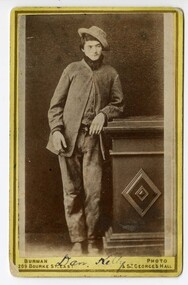 Victoria Police Museum
Carte de Visite (Dan Kelly standing), Dan Kelly (standing)
Carte-de-visite is a small black and white photograph stuck to a card. It was invented by French photographer Andre Disderi in 1854 as a method for producing multiple images on a single glass plate, a format for mounting the resulting images on cards. The card on which the photograph was mounted displayed the name of the photographer on the front and back. The back was often a showy piece of lithographic printing with the photographer's name decorated with culicues.Sepia toned photograph on card showing Dan Kelly with left arm resting on a pillar."Burman Photo 200 Bourke St - East & St Georges Hall" (under photograph). "From Burman's Photographic Rooms 209 Bourke Street. East Near parliament Houses. St Georges Hall Next to Theatre Royal Melbourne. Portraits Enlarged, Copied or Colored. Views taken in any part of Victoria. Copies of this can be had at any time: (on rear) "Dan Kelly" (handwritten in ink underneath image on front of card)dan kelly, kelly gang, ned kelly, carte-de-visite, burman -
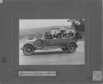 Emerald Museum & Nobelius Heritage Park
Photograph, Nightingale/Thompson Collection, 1923
Professional photograph possibly taken by Middletons Touring Service of group in Middletons touring car. For further information see link: http://trove.nla.gov.au/ndp/del/article/86067542?searchTerm=middletons%20car%20touring%20service&searchLimits=Part of the Thompson collection cannot find any reference to persons under the Nightingale/Thompson family historySepia photograph mounted on brown card, showing group of people in 4 seater car On brown card: Souvenir - Jenolan Caves sticker on bottom R/H corner Middletons Touring Service Tel: 117 KAT On back of photograph: on 21st March 1923 Miss Louise and I wnt in our Middletons car (a Hudsons Car) this photo was taken at Hartly in front of the old court house and prison. Built by the convicts in 1833 on the way to the Jenolan Caves. This is a Birthday gift from Dear cousin Louie (name to be confirmed)thompson collection, nightingale -
 Ringwood and District Historical Society
Photograph, Construction of Ringwood baths, Miles Avenue. Construction began in January 1934 and the pool was officially opened in November that year
Coloured photograph. Photograph taken by "Mervyne" Ringwood Studios."Written on back of photograph" Ringwood baths under construction. Photo taken from corner of Ringwood St & Miles Ave. Houses just above baths are in Reynolds Ave & top left in Warrandyte Road. Top centre- corner Warrandyte Road & Woodside Ave. White railing centre right is on the bridge across Mullum Creek. Adelaide St ran from Maroondah Highway to Reynolds Ave. Bridge later washed away- 1931. -
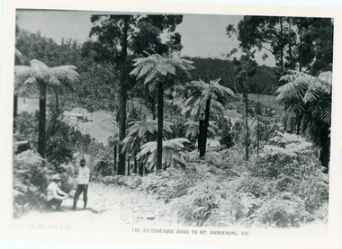 Mt Dandenong & District Historical Society Inc.
Photograph, View From Doughty's Road 1913
Mt Calvin, the homestead of Jeanie and Willie Richardson can be clearly seen in the clearing above the men in the picture. The white roof of the Barber homestead is on the right of the picture. A landslide in 1934 destroyed the tree ferned area. John Lundy-Clarke grew up in the Kalorama/Mt Dandenong area and later in life (1972-74) began to write a comprehensive history of the area working from an original settlement map in an effort to cover all areas.Black and white photograph that is a copy of a Rose series postcard titled 'The Picturesque Road to Mt. Dandenong. Vic.' It shows two men (probably Rose Series employees), one sitting and one standing at the edge of an unmade road. Large tree ferns line the roadside. Handwritten inscription on reverse by John Lundy-Clarke1913 View east from Doughty’s Road showing Jeannie Richardson’s home through the gap in the trees. A little to the right of and below centre of picture can be seen George Barber’s home with Barbers Road turning around the wagon shed that was a little up the hill from the house. The tree ferns in the picture were destroyed in the landslide of 1934. In the distance at the right can be seen F.M. Childs Homestead complex with the Richardson paddocks beyond it.mt calvin, jeanie richardson, willie richardson, george barber, landslide, tree fern -
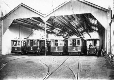 Ballarat Tramway Museum
Photograph - Black & White Photograph/s, 1915
Yields information about the form and style of the early Geelong trams and in particular one of the cross bench trams.Black and white photograph, printed onto card (inkjet printer?) of the front of the Geelong depot soon after the opening of the tramway, four roads - 1915. Has trams 2, 8, 4 and 1 on front of the track and alongside is a small motor bus and a motorcycles. Each tram has a person vehicle in the front. Shows depot arrangements. Two copies held. Dave O'Neil advised 20/7/2009 - agree with date.Copy 1 - " Depot view about 1915 - Geelong Hist Soc / W F S Collection." Copy 2 on rear "Depot view about 1915. Note bus in right road. Buses were housed there until 1922" in Bill Scot's handwriting and in bottom right hand corner "William F. Scott" address label. and "20" in top left hand corner. Also "Geelong Trys" "C1915" and "W.F. Scott Collection." trams, tramways, geelong, depot, buses, tram 1, tram 2, tram 8, tram 4 -
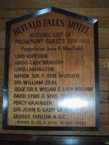 Parks Victoria - Mount Buffalo Chalet
Plaque, "Buffalo Falls Hotel / Historic list of prominent guests 1888-1919"
Possibly predates Chalet. ".There is also a wooden plaque displaying the names of notable guests who stayed at the Buffalo Falls Hotel that once stood at the foot of the mountain. the pioneering Manfield family opened this early hotel in the late 1880's and soon began taking visitors on walking treks up onto the plateau." (Pg 84 Historica, 2011). The Buffalo Falls Hotel was originally known as The Buffalo Falls Temperance Hotel and was built in 1888 by James Manfield. His daughter Alice became well known as a Mt Buffalo guide and was renowned for her mountain knowledge as well as for her distinctive alpine pant suit. The Hotel was constructed opposite the newly opened 'Staker's Track', a walking track , now known as the "Big Walk" was, a steep 6 hour walk, which nevertheless opened the mountain up to early tourism, attracting leading figures from Melbourne Society as well as significant artists, Naturalists and Scientists eager to explore and experience the unique scenery and geological features of the Mountain. Baron Von Mueller as Government botanist was one of the first white men to ascend to the plateau in 1853, collecting alpine specimens . Each of the names on this honor roll were significant cultural and society figures of Victorian/Edwardian Melbourne .Listed in Draft Inventory of Significant Items. Appendix A3. Framed Photographs, Pictures, etc. (Pg 165, Historica, 2011)Wooden plaque with black painted inscription, framed in black painted wood. Plaque is peaked at the top."BUFFALO FALLS HOTEL.... Historic list of prominent guests 1888-1919. Proprietor Jane R. Manfield. Lord Hopetoun. Lord & Lady Brassey. Lord Lamington. Baron Sir F. Von Mueller. Sir William Zeal. Judge Sir H. William & Lady William. David Syme & Mrs Syme. Percy Grainger. Sir John & Lady Monash. George Farlow A.D.C. Prepared by Geo. W. Sykes "Buffalo House'." -
 Federation University Historical Collection
Magazine, Ballarat School of Mines Students' Magazine, 1965, 1965
The editorial committee for the 1965 Ballarat School of Mines Student Magazine was Trevor Barnett, Gary Bunn, Roger Donaldson, Fred Evans, Ralph Fenney, Greg Hunter, Jon McDonald, Malcolm Park, Geoff Pollard, Gary Roberts, Peter Smith and John Thorne. In 1965 Morgan B. John was President of the Ballarat School of Mines, and the Principal was E.J. (Jack) Barker.White soft covered magazine of 91 pages with black line drawings and caricatures on the cover designed by Trevor Barnett. Articles include: The importance of Library Services, a list of Diplomas conferred and prizes presented, Camping Daze, The Civilising Influences of Mining, Jigging in Beds (bed race), Art School, Sed Education, War, Man's Neurotic flaw, National Service, In Man A Brute?, Journey into the Unknown, Philosophy of Games; Roll Call 1965. Snippits include: Trevor Barnett announced as the winner of the Eric Mcgrath Award for 1965; Wayne Johnson was awarded the Honour Blazer. The deaths of Noel Hooper, David Bell and Shane Carroll were recorded. Numerous black and white images but no name captions. Advertisements by Ronaldson and Tippett, Electrolytic Zinc Company of Australasia, BHP, Mount Isa Mines, Australuco Aluminium, Owen's of Ballarat. Alexandria Tea Rooms, Roy Bracks Mens Wear, A.J. Williams Electrical Equipment, Young Squire, H.B. Selby & Co., The Wattle, T.J. Coutts, H.A. Davis Motor Service, Henderson-Palmer, Philips Electrical, Myers, M.B. John & Hattersley Limited, Andrew Gault, Tait Book Company, BHAS, Morsheads, Commonwealth Aircrafts Corporation, J.J. Mortimer, Ewins, B. and G. Myers ballarat school of mines, roger donaldson, gary bunn, trevor barnett, noel hooper, david bell, shane carroll, vietnam war, national service, bracks slacks, fred evans, ralph fenney, greg hunter, jon mcdonald, malcolm park, geoff pollard, gary roberts, peter smith, john thorne -
 Federation University Historical Collection
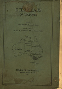
Book, Mines Department, Victoria, Deep Leads of Victoria, 1937, 1937
Charcoal green soft covered book of 64 pages. Contents include Ballarat, berry Consols, Canadian Lead, Castlemaine-Daylesford System, Chiltern, Duke of Cornwall Mine, Dyke's Freehold, Frenchman's Lead, Garibaldi Shaft, Glenfine, Guidlford, Hepburn Estate Co., Hepburn Home Paddock, Italian Gully, Henderson's Lead, Langi Logan, Leigh Consols, Sebastopol Plateau; Talbot, Woady Yalloak, A definition of a deep lead, formation of deep leads, water in deep leads, methods of deep lead mining (Tunnelling, Deep sinking, Chiltern method of working, Ballarat method of working), sampling washdirt and gravels, Balmoral, Mt William, Stawell, Moyston, Great Western, Ararat, Raglan, Wimmera Valley, Landsborough, Cardigan, Haddon, Beaufort, Waterloo, Avoca, Lamplough, Caralulup, Ballarat West, Ballarat, Smythesdale, Glenfine, Illabarook, Durham Lead, Morrison's Lead, Bullengarook, Berry-Moolort-Loddon System, Clunes, Creswick, Spring Hill, Bullarook, Castlemaine - Daylesford, Majorca, Carisbrook, Timor, Burnt Creek Tributary, Tarnagulla, Marong, Rheola, Inglewood, Huntly, Coliban, Campaspe, Goulburn Lead System, Ovens Valley System, Mitta Mitts, Kiewa Valley, Tarago, Tanjil, Moondarra, Bogong, Dargo High Plains, glossarymining, deep leads, mines department, squire, leigh consols, chiltern, duke of cornwall mine, dyke's freehold, frenchman's lead, garibaldi shaft, glenfine, guidlford, hepburn estate co., hepburn home paddock, italian gully, henderson's lead, langi logan, sebastopol plateau, talbot, woady yalloak, tunnelling, deep sinking, chiltern method of working, ballarat method of working, sampling washdirt. gravels, balmoral, mt william, stawell, moyston, great western, ararat, raglan, wimmera valley, landsborough, cardigan, haddon, beaufort, waterloo, avoca, lamplough, caralulup, ballarat west, ballarat, smythesdale, illabarook, durham lead, morrison's lead, bullengarook, berry-moolort-loddon system, clunes, creswick, spring hill, bullarook, castlemaine - daylesford, majorca, carisbrook, timor, burnt creek tributary, tarnagulla, marong, rheola, inglewood, huntly, coliban, campaspe, goulburn lead system, ovens valley system, mitta mitta, kiewa valley, tarago, tanjil, moondarra, bogong, dargo high plains -
 Department of Health and Human Services
Photograph, Berry Street Kindergarten
In 1877 the Victorian Infant Asylum was founded in Kew. In 1881, the asylum relocated to Berry Street in East Melbourne. By 1908, it was called the Foundling Hospital and Infants Home. It was non-denominational and controlled by a committee of management. By 1956, Berry Street consisted of a Mothercraft Training Centre and two main residential units: Berry Street for infants aged zero to 18 months, and Vale Street for toddlers aged zero to two years old. In August 1956, Berry Street was declared an approved category 2 Children's Home. In 1960, Vale Street was converted to an adult nursing home. In 1964, the name was changed to Berry Street Babies Home and Hospital. Berry Street was also an approved adoption agency. By 1968, Berry Street comprised the Training School for Mothercraft Nurses, the adoption agency, an infant life-protection house, a long-stay home for children to three years of age (the toddlers’ wing) and a small house for unmarried mothers. The home's infant life-protection work was seen as a critical agency function, particularly where family illness was putting pressure on mothers and Berry Street was able to provide respite and support. By the late 1960s, 30–40 adoptions annually were being arranged from Berry Street. By 1974 the home's orientation had shifted. Four family group homes had been established (two in Burwood, one in Ashburton and one in St Kilda), the mothercraft training function had been phased out, the toddlers wing converted to day care, and the main building (containing the nursery, administration, kitchen, dining room and single mothers accommodation) was demolished in favour of four home units, which housed 24 children, supervised by cottage parents. Berry Street provided short term, emergency and residential care for 'protection of infant' cases and state wards. Two flats were also established for short-term family accommodation. The nurses’ home was converted to house the home’s administration function and a social work service. The social work service coordinated family aid and family counselling services, and a neighbourhood house. In 1975 Berry Street also provided short-term care for 42 Vietnamese children brought to Australia in the official government-sponsored airlift. In 1976 Berry Street made application to change its category 2 Children's Home classification to category 1, as it was now catering for a wider range of children. It had ceased to be a babies’ home and hospital, and had started providing child and family care, including residential care. In 1977 Berry Street to established a family group home in Richmond to house children affected by the closure of St Cuthbert's Children's Home in Colac. Berry Street changed its name to Berry Street Child and Family Care in 1977. In 1978, the range of services provided by Berry Street Child and Family Care consisted of a social work counselling service, a financial aide, a family aide program using volunteers, two temporary accommodation units each housing eight children, an information and referral service, a neighbourhood house in Richmond, a day care centre for 36 children, and four family group homes. In 1980–81 the family group homes in Burwood were sold and the resources moved to the Richmond area. In 1994, Sutherland Youth and Family Services Inc. amalgamated into Berry Street Inc. During the 1990s, Berry Street combined with the Sutherland Community Resource Centre in Watsonia in Melbourne’s northern region. The agency operates today as Berry Street Victoria and has service centres across metropolitan and country Victoria. https://www.findingrecords.dhhs.vic.gov.au/CollectionResultsPage/BerryStreet -
 Kiewa Valley Historical Society
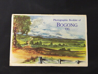
Booklet - Bogong, Photographic Booklet of Bogong Vic
This booklet was produced to advertise Bogong Village and surrounding areas. The photos depict the area's buildings and equipment being used at the time. Bogong Village housed the State Electricity Commission of Victoria's employees working on the Kiewa Hydro Electric Scheme which began in the 1930's and finished in the 1960's. Maisie describes her visit in May 1958 giving an insight into the area including the weather and the roads.The photos indicate what the area around Bogong looked like c1958 towards the end of construction but before the bush grew back after the 1939 fires at Bogong village and after construction of the shopping centre at Mt Beauty. A sno' cat and snow plough are also shown emphasising the change in machinery over the years. This enables comparisons to be made in many areas of study.A fold down booklet postcard size of 9 black and white photos of Bogong village and surrounds and a letter addressed to Mrs. A. Parnell of Sydney from Maisie. Maise's husband has 2 married sisters living near Bogong on farms. The booklet is in a clear plastic sleevePostage stamp arrived in Sydney 28th May 1958.bogong. lake guy. howman gap hostel. mt beauty.bogong high plains. -
 Warrnambool and District Historical Society Inc.
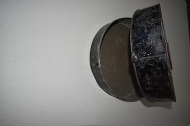
Hat Box, Early 20th century
This hat box could have been used for either a man’s or a woman’s hat in the days when it was the custom for both men and women to wear a hat when outside the house or on social occasions. It would have been used in the home or for travel, especially when on board a ship. Hat boxes today may still be used but are usually made of cardboard or other less durable material.This box was acquired over 40 years ago from a local person. It is retained for display purposes.This is a round metal box with a circular base and a lid affixed with a metal hinge. The lid is wider at the front of the tin allowing for extra height for the stored item. The lid had a metal clip handle and there is a front metal clip for closing the box. The tin has been painted black but is much rusted, particularly on the top section. vintage headgear, history of warrnambool