Showing 2124 items matching " john hall"
-
 Mt Dandenong & District Historical Society Inc.
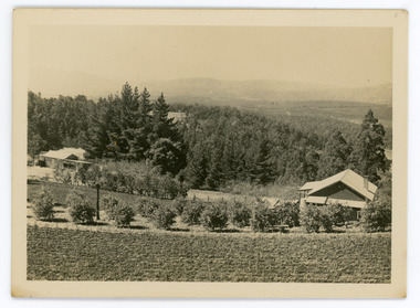
Photograph, Walker's LOT 2
Harry Walker's property would have been run by his son William in 1922. When the CRB Road cut through the property William planted plum trees on the opposite side. These are visible in this photo. An extensive raspberry crop is in the foreground. The building over the road on the left hand side is the corn and produce store built by Edward John Price (son of Edward Joseph Price) to capitalise on the CRB Road cutting through the Price farm. John Lundy-Clarke grew up in the Kalorama/Mt Dandenong area and later in life (1972-74) began to write a comprehensive history of the area working from an original settlement map in an effort to cover all areas.Small black and white postcard showing a crop in foreground with a house to the right. A road passes through the centre with a house on the left on the opposite side of the road. A view to the ranges in the distance. A handwritten description on reverse by John Lundy-Clarke.View at Kalorama. View over LOT 2 (Walkers) 1922.harry walker, william walker, crb road, raspberry, edward john price, edward joseph price, produce store, store -
 Mt Dandenong & District Historical Society Inc.
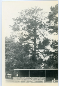
Photograph, Hand's Pine Tree in Kalorama Reserve
Kalorama Memorial Reserve was once the location of 'Mountain Grange', the property of Thomas and Eliza Hand. The pine tree pictured was reputedly planted by Mrs Eliza Hand in the 1880s. Thomas Hand died in 1888 when he was thrown from his horse on Inverness Road. The photograph was taken in 1974 and the pavilion pictured is no longer there. John Lundy-Clarke grew up in the Kalorama/Mt Dandenong area and later in life (1972-74) began to write a comprehensive history of the area working from an original settlement map in an effort to cover all areas.Black and white photograph showing a large pine tree behind a pavilion. Handwritten description on reverse by John Lundy-Clarke.Hand’s pine tree in Kalorama reserve. Planted 1874 approx. Pictured 14-3-73.kalorama memorial reserve, kalorama oval, mountain grange, thomas hand, eliza hand, pine tree, pavilion -
 Mt Dandenong & District Historical Society Inc.
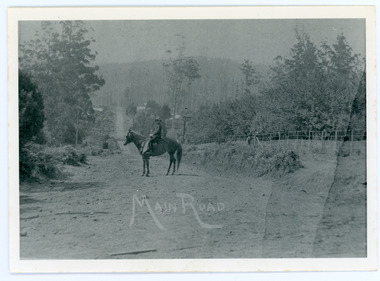
Photograph, Looking Down Falls Road
Edward John Price was a son of early settler Edward Joseph Price. Edward Joseph was the first settler in the Village Settlement when he took out Lot 1, Section 1. He built a small home of slabs and brought his family up in 1896. From the outset the Price family ran a store from their home.This picture, taken 1914, shows Edward John Price on his pony delivering papers from his parent's newsagency that was opposite 'Mountjoy' guesthouse on Ridge Road. He was taking them to Lily Badenhop's post office in Blythe's Road. The section of road he is on was called Main Road and is now Falls Road.Black and white photograph showing a man on horseback in the centre of an unmade road that is running into the distance.Trees, a fence and houses can be seen with hills in the background. Reverse of photograph has handwritten description by John Lundy-Clarke.On Front MAIN ROAD On Reverse Looking down Falls Road then the main road in 1914. Before Frank Craig built The Fron (1918). Dunbar’s house Halcyon on left of road. The hall on its right with Keogh’s sheds showing further in the trees. The horseman is Edward John Price who delivered the daily papers to Lil Badenhop’s shop. The bag he carried them in can be seen hanging from the saddle pommel. The first road formation can be seen on the bank to the right. The road seen was constructed 1905 by Bill McGivern.edward john price, edward joseph price, lily badenhop, post office, falls road, main road, mountjoy, frank craig, bill mcgivern, dunbar, halcyon, keogh, farndons hall -
 Mt Dandenong & District Historical Society Inc.
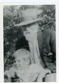
Photograph, Edward Joseph Price and Grandson
John Lundy-Clarke grew up in the Kalorama/Mt Dandenong area and later in life (1972-74) began to write a comprehensive history of the district working from an original settlement map in an effort to cover all areas. Edward Joseph Price took out Lot 1, Section 1 of the Village Settlement and became the first settler, moving his family up into a slab hut on his selection in 1896. Edward Joseph had two sons (Charles Joseph and Edward John) and a daughter (Kathleen Nathalie Caroline). Edward Joseph Price is holding his grandson Teddie, son of Edward John Price. Photo taken 1936.Black and white photograph in close up showing an old man with a white beard wearing a brimmed hat holding a male toddler under the arms. Reverse of photograph has handwritten description by John Lundy-Clarke.Edward Joseph Price and his grandson Teddie son of Edward John. E. Joseph was the first settler in the Village Settlement choosing LOT 1, part of which is still family property (1974). He worked for the surveyors who were marking out the blocks, and disregarded their advice as to which had the best soil, and so doing he obtained the best commercially. He died in 1943 leaving two sons & daughter. Edward John born 1899 died 1974. Charles born 1892 died 1958. Kathleen born 1895 died 1954. Wife Annie nee Ross died 1932.edward joseph price, edward john price, teddie price -
 Mt Dandenong & District Historical Society Inc.
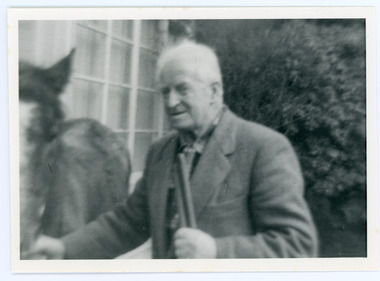
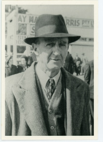
Photograph, Edward John Price 1973
John Lundy-Clarke grew up in the Kalorama/Mt Dandenong area and later in life (1972-74) began to write a comprehensive history of the district working from an original settlement map in an effort to cover all areas. Edward John Price (Ted)(1899-1974) was the third child of Edward Joseph and Annie Price. He lived a very industrious life in the area. When the new CRB road cut through the family land Edward John established a Corn and Produce store on a level area adjoining the new road . Along with his brother Charlie, Ted took up road contracting and formed Grange Road in 1923. They also took up contracts to metal the CRB road between The Gap and Olinda. Edward John married Myra Wilson in 1930. They lived in the first brick home built in the district. They had two sons, Edward Joseph 2nd and Alan.Black and white photograph showing an old man dressed in a jacket holding the reins of a horse. Reverse of photograph has handwritten description by John Lundy-Clarke.Edward John Price 1973. Son of Edward Joseph & Annie Ada nee Ross. Born 1899 died 1974. Farmer, Carrier, Sawmiller, Contractor, Quarry Owner, Shop Proprietor (Kew Junction 1935). Father of Alan & Edward J.edward john price, myra wilson, edward joseph price, annie price, alan price, charles price, grange road, crb road -
 Mt Dandenong & District Historical Society Inc.
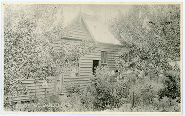
Photograph, Home and Shop of Edward Joseph Price
John Lundy-Clarke grew up in the Kalorama/Mt Dandenong area and later in life (1972-74) began to write a comprehensive history of the district working from an original settlement map in an effort to cover all areas. Edward Joseph Price was the first settler to take up a lot (Lot 1, Section 1) in the Village Settlement. He built a slab hut and brought up his family in 1896. This photograph shows a newer home built in 1908. It had a section used as a shop and also had a large room built that was to be used for public gatherings. Health department regulations led to this being impossible. The house faced Ridge Road.Black and white close up photograph showing a building made from wooden boards with trees in the front. Reverse of photograph has handwritten description by John Lundy-Clarke.On Front STORE MT DANDENONG On Reverse Home and Shop of Edward Joseph Price LOT 1 SECT 1 erected in 1908 on site of earlier dwelling from which goods had been sold without a special room for shop. In picture the room on the extreme left was bedroom for boys Charlie and Ted (Edward John). Under the gable was a large room planned for public use but never used owing to Health Department Regulations. The narrow door (open) and window were the shop which was the district’s first newsagency. Window behind leaves at right was the kitchen. 1908-1912. Gabled portion is now part of home “Mirra Laken” 1975edward joseph price, store, shop -
 Mt Dandenong & District Historical Society Inc.
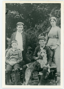
Photograph, Clarke Family 1911
John Lundy-Clarke grew up in the Kalorama/Mt Dandenong area and later in life (1972-74) began to write a comprehensive history of the district working from an original settlement map in an effort to cover all areas. The Lundy-Clarke family were related to the Price family through the marriage of two Ross sisters - Annie Ross to Edward Joseph Price and Helen Ross to Robert Lundy-Clarke. Edward Joseph Price took up Lot 1 in the Village Settlement and Robert Lundy-Clarke was persuaded to take up Lot 2. He felt it would be unproductive. He signed it over to Edward Joseph Price and took his family to New Zealand. After his death in 1911 the family returned to the district. The Lundy-Clarke family were related to the Dunbar family as Caroline Dunbar was a sister to Annie and Helen Ross. Agnes Annie Clarke aged 18 daughter of Robert Lundy-Clarke and Helen nee Ross. Born 1893 died 1974. James Ross Clarke aged 12 son of Robert Lundy-Clarke and Helen nee Ross. Born 1898 died 1972. John Lundy-Clarke aged 10 son of Robert Lundy-Clarke and Helen nee Ross. Born 1901 died 1993. John Stewart Dunbar aged 13 son of Andrew Dunbar and Caroline nee Ross. Born 1898. This photograph was taken in 1911 in the grounds of Dunbar's Hazeldene Dairy in Falls Road. Black and white photograph showing four young people outdoors in a group. A girl and boy standing with two boys seated on chairs, one holding a dog. Reverse of photograph has handwritten description by John Lundy-Clarke.1911 Right to left - Agnes Annie Clarke aged 18 daughter of R. Lundy-Clarke and Helen nee Ross. Born 1893 died 1974. James Ross Clarke aged 12 brother of Agnes. Born 1898 died 1972. John Stewart Dunbar son of Andrew Dunbar and Caroline nee Ross. Born 1898. John Lundy-Clarke. Brother of Agnes with "Possum" (Apart from Agnes, not sure of the accuracy of the other name placements)lundy-clarke, john lundy-clarke, robert lundy clarke, agnes clarke, james clarke, john dunbar, andrew dunbar, caroline dunbar, caroline ross, helen lundy-clarke, helen ross, annie ross, annie price, dairy, hazeldene, hazeldene dairy, dunbar's dairy, falls road -
 Mt Dandenong & District Historical Society Inc.
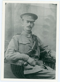
Photograph, Charles Joseph Clarke
Charles Joseph Clarke (1890 - 1920), is the son of Robert and Helen (nee Ross) Lundy-Clarke is the brother of Agnes Clarke, James Ross Clarke and John Lundy-Clarke.Black and white studio portrait of man in WW1 army uniform. Reverse of photograph has handwritten description by John Lundy-Clarke.Charles Joseph Clarke. Son of Robert Lundy-Clarke and helen nee Ross. Married Stella Kay 1913. Father of Jock Andrew Charles Edward Stellacharles clarke, robert lundy-clarke, helen lundy-clarke, helen ross, agnes clarke, james clarke, john lundy -clarke, stella kay -
 Mt Dandenong & District Historical Society Inc.
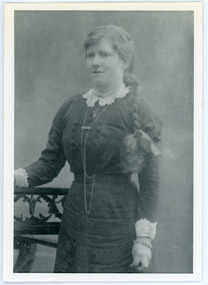
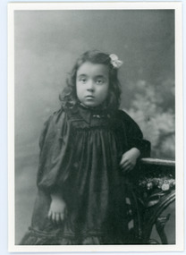
Photograph, Kathleen Price
Taken c1911, this photograph shows Kathleen Price (1894 - 1954) aged 18. Kathleen was the daughter of early settlers on Lot 1 of the Village Settlement, Edward Joseph and Annie (nee Ross) Price. Kathleen had two brothers - Charles born 1893 and Edward John born 1899. The family worked their business as equal partners. Kathleen married Frank Gardiner in 1916 and moved to Bateford , Geelong.Black and white studio photograph showing a young girl with a plait hanging over her left shoulder. Reverse of photograph has handwritten description by John Lundy-Clarke.Kathleen Price aged 18. Daughter of Edward Joseph Price and Annie Ada nee Ross. Married Frank Gardiner of Geelong (Batesford) in 1916. Children - two daughters and six sons. Died 1954.kathleen price, kathleen gardiner, frank gardiner, charles price, edward john price, edward joseph price, annie price, annie ross -
 Mt Dandenong & District Historical Society Inc.
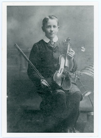
Photograph, Edward John Price aged 14
John Lundy-Clarke grew up in the Kalorama/Mt Dandenong area and later in life (1972-74) began to write a comprehensive history of the district working from an original settlement map in an effort to cover all areas. Edward John Price (1898 - 1974) was the son of early settlers on Lot 1 of the Village Settlement Edward Joseph Price and Annie (nee Ross) Price. He was the brother of Charles and Kathleen Price. Edward John married Myra Wilson in 1930.Black and white studio portrait showing well groomed boy holding a violin. Reverse of photograph has handwritten description by John Lundy-Clarke.Edward John Price aged 14. Son of Edward Joseph Price and Annie Ada nee Ross. Farmer, sawmiller, logging contractor,. proprietor of shop at Kew Junction 1935. Quarry master (Kilsyth). Father of Alan and Eddie J. A daughter died young. Married Myra Wilson 1930. Died 1974.edward john price, edward joseph price, annie price, annie ross, kathleen price, charles price -
 Mt Dandenong & District Historical Society Inc.
Photograph
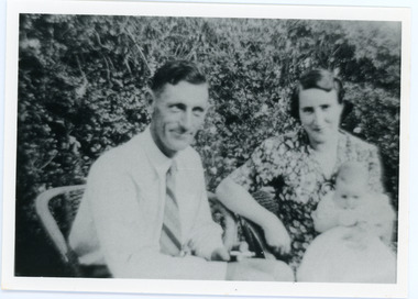
The Wenborn family acquired Ferguson's Lot 19 of the Village Settlement where the original Mount Dandenong School was opened in a shed. WH Collom owned the land after Ferguson and then it passes to the Wenborns. This photograph shows Jim Wenborn with his wife Ivy and daughter Mary. The Wenborns had another daughter, Joan. Both children attended Mt Dandenong State School. John Lundy-Clarke grew up in the Kalorama/Mt Dandenong area and later in life (1972-74) began to write a comprehensive history of the area working from an original settlement map in an effort to cover all areas.Black and white photograph showing a man and woman seated in a garden. The woman is holding a small baby. Handwritten inscription on reverse by John Lundy-ClarkeJim Wenborn and family.wenborn, jim wenborn, ivy wenborn, mary wenborn, joan wenborn, ferguson, wh collom, mt dandenong school -
 Mt Dandenong & District Historical Society Inc.
Photograph
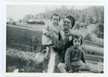
The Wenborn family acquired Ferguson's Lot 19 of the Village Settlement where the original Mount Dandenong School was opened in a shed. WH Collom owned the land after Ferguson and then it passes to the Wenborns. This photograph, taken c1942, shows Ivy Wenborn with her daughters Mary and Joan. John Lundy-Clarke grew up in the Kalorama/Mt Dandenong area and later in life (1972-74) began to write a comprehensive history of the area working from an original settlement map in an effort to cover all areas.Black and white photograph of a woman nursing a young girl Another young girl is seated at her right.Behind is a view of trees and a house. Handwritten inscription on reverse by John Lundy-ClarkeWenborn Family. Looking across what is now Kalorama Park showing Norman Jeeves' house behind the hedge to the left of the child.wenborn, ivy wenborn, mary wenborn, joan wenborn, norman jeeves, kalorama park, jeeves -
 Mt Dandenong & District Historical Society Inc.
Photograph
Elissa Leila Hannah Gerlach was born in 1902 and was the daughter of Carl and Kate (nee Bridges) Gerlach. Elissa married William Henry Jackson in 1925.Black and white studio portrait of a young girl. Handwritten inscription on reverse by John Lundy-ClarkeElissa Girlac 1905. Mrs Bill Jackson.gerlach, elissa gerlach, carl gerlach, kate gerlach, william jackson, bill jackson -
 Mt Dandenong & District Historical Society Inc.
Photograph
William Henry Jackson married Elissa Leila Hannah Gerlach in 1925. Note: Gerlach, not 'Girlac' as in the inscription.Black and white photograph of a man in a hat and coat standing outside in an area with signs in the background and people walking along. Handwritten inscription on reverse by John Lundy-ClarkeBill Jackson. Husband of Elissa Girlac.elissa gerlach, elissa jackson, william jackson, bill jackson -
 Mt Dandenong & District Historical Society Inc.
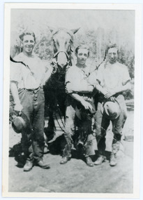
Photograph
Eric Wilson was the brother of Beatrice Myra Wilson (Myra) who married Edward John Price.Black and white photograph showing three young men with hats in their hands standing in front of a work horse. Handwritten inscription on reverse by John Lundy-ClarkeEric Wilson & mates with "Boxer" 1926. Brother-in-law of E. John Price.eric wilson, myra wilson, edward john price -
 Mt Dandenong & District Historical Society Inc.
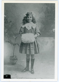
Photograph
Beatrice Myra Louise Wilson (Myra) married Edward John Price in 1930. According to John Lundy-Clarke Myra was the daughter of the man who rebuilt the Mt Dandenong State School in 1920, separating the school building from the school house.Black and white studio portrait of a young girl standing with her hands inside a fur muff. Handwritten inscription on reverse by John Lundy-Clarke Myra Wilson aged 10. Mrs E. John Price.myra wilson, myra price, edward john price, mt dandenong school -
 Mt Dandenong & District Historical Society Inc.
Photograph, Site of Jeannie Richardson's Home 1973
John Lundy-Clarke grew up in the Kalorama/Mt Dandenong area and later in life (1972-74) began to write a comprehensive history of the area working from an original settlement map in an effort to cover all areas. It was in the clearing on the left that John William (Willie) Richardson built a home for his wife Jeanie Green. It was called Mount Calvin. Jeanie was often ill and the family left the area seeking a warmer climate. They eventually settled in Brisbane. Willie sold the home and 60 acres around it to W. Rowse. Jeanie died in 1916. The remainder of the land was sold by solicitors to cover debts. Black and white photograph showing a treed hillside with a cleared area to the left hand side. Handwritten inscription on reverse by John Lundy-ClarkeLooking towards the site of Jeannie's home from near Doughty’s Road Nov 1973. Her house was in the centre of the clearing on the left. Photo Jan 1974 JLC.mount calvin, jeannie richardson, jeanie green, john william richardson, willie richardson, jeanie richardson, rowse -
 Mt Dandenong & District Historical Society Inc.
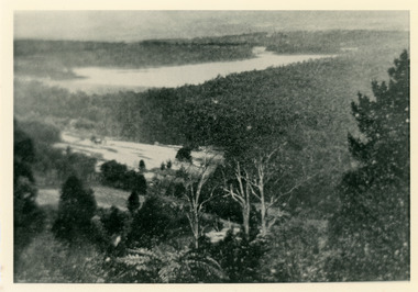
Photograph, Harmony Vale 1933
John Lundy-Clarke grew up in the Kalorama/Mt Dandenong area and later in life (1972-74) began to write a comprehensive history of the area working from an original settlement map in an effort to cover all areas. Harmony Vale was the name of the homestead built by early pioneer Jabez Richardson. The whole of the valley took on this name. The building lasted until 1933. The Silvan Dam was completed in 1932 and was full when this photograph was taken.Black and white photograph looking down over a forested area with a dam in the background. Copied from a Rose Series postcard c1933. Handwritten inscription on reverse by John Lundy-ClarkeRose Series photo of 1933 showing “Harmony Vale” still standing. Copied 1973 JLCharmony vale, silvan dam, jabez richardson -
 Mt Dandenong & District Historical Society Inc.
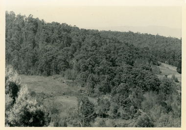
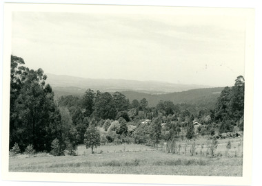
Photograph, View From Doughty's Road 1974
John Lundy-Clarke grew up in the Kalorama/Mt Dandenong area and later in life (1972-74) began to write a comprehensive history of the area working from an original settlement map in an effort to cover all areas. This photograph shows approximately the same area as photograph number KAL0193 but is taken 60 years later. The trees have grown much taller and the buildings changed. On the site of the Paynter house 'Iona' there is now the 'Yosemite' (Villa Toscana) accommodation. The pavilion in the centre of the photo is the site of 'Kalorama', home of early pioneer Isaac Jeeves. The photograph is taken looking up towards The Gap (FiveWays).Black and white photograph showing a forested area with clear sites. Roofs of buildings can be clearly seen. Handwritten inscription on reverse by John Lundy-ClarkeView from near Doughty’s Rd looking north up valley to Kalorama Gap in Jan 1973. Tiny roof in centre is pavilion on site of “Kalorama”. Long roof to its left is Yosemite Motel on site of “Iona”.paynter, kalorama, iona, yosemite, villa toscana, five ways, the gap -
 Mt Dandenong & District Historical Society Inc.
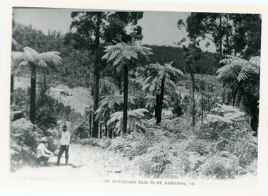
Photograph, View From Doughty's Road 1913
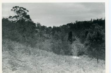
Mt Calvin, the homestead of Jeanie and Willie Richardson can be clearly seen in the clearing above the men in the picture. The white roof of the Barber homestead is on the right of the picture. A landslide in 1934 destroyed the tree ferned area. John Lundy-Clarke grew up in the Kalorama/Mt Dandenong area and later in life (1972-74) began to write a comprehensive history of the area working from an original settlement map in an effort to cover all areas.Black and white photograph that is a copy of a Rose series postcard titled 'The Picturesque Road to Mt. Dandenong. Vic.' It shows two men (probably Rose Series employees), one sitting and one standing at the edge of an unmade road. Large tree ferns line the roadside. Handwritten inscription on reverse by John Lundy-Clarke1913 View east from Doughty’s Road showing Jeannie Richardson’s home through the gap in the trees. A little to the right of and below centre of picture can be seen George Barber’s home with Barbers Road turning around the wagon shed that was a little up the hill from the house. The tree ferns in the picture were destroyed in the landslide of 1934. In the distance at the right can be seen F.M. Childs Homestead complex with the Richardson paddocks beyond it.mt calvin, jeanie richardson, willie richardson, george barber, landslide, tree fern -
 Mt Dandenong & District Historical Society Inc.
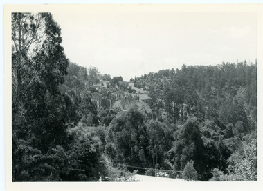
Photograph, View Up Valley Towards Kalorama Gap 1973
John Lundy-Clarke grew up in the Kalorama/Mt Dandenong area and later in life (1972-74) began to write a comprehensive history of the area working from an original settlement map in an effort to cover all areas. This photograph would have been taken to show the changes in the area over the years. Kalorama Gap is now called Five Ways. 'Kia-Ora ' was a guest house built by George Barber. It is no longer standing.Black and white photograph showing a bush scene with a white car visible on the right. Handwritten inscription on reverse by John Lundy-Clarke1973 View up Valley towards Kalorama Gap from what was Crooks LOT 24. White car is on Barbers Road and site of “Kia Ora” is to right of it.kalorama, kalorama gap, five ways, barbers road, george barber, kia-ora -
 Mt Dandenong & District Historical Society Inc.
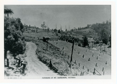
Photograph, View From Corner of Doughty's Road and Barbers Road 1913
John Lundy-Clarke grew up in the Kalorama/Mt Dandenong area and later in life (1972-74) began to write a comprehensive history of the area working from an original settlement map in an effort to cover all areas. Taken c1913, this photograph gives a clear indication of where significant buildings were located in relation to one another. Barbers Road is running through the picture with the guest house 'Kia-Ora' , built by George Barber in the centre. High on the skyline on the left is the 'Mountjoy' guesthouse, indicating the location of The Gap, or FiveWays. The small 'boxy' house above 'Kia-Ora' is 'Iona' built by the Paynter family who also built 'Mountjoy'. The Jeeves property 'Kalorama' is to the right of 'Iona' and this is the area you now look to from the FiveWays Lookout. The man in the photo is wearing a trilby hat so is probably a Rose Series employee - a feature in many Rose Series postcards.Black and white photograph that is a copy of Rose Series Postcard # 156. A man can be seen walking down an unmade road with haystacks to his right. Buildings and crops can be seen on the hillsides. Handwritten inscription on reverse by John Lundy-ClarkeView from corner of Doughty’s and Barbers Road 1913. “Kia Ora” in centre Paynter’s “Iona” near center skyline above “Kia Ora” with “Kalorama” on its right and Peter’s hut of the time below it among orchard trees. “Mountjoy” is on left skyline. W. Haye’s home is centre left. Hay paddock is Barbers Lot 25 Village Settlement.kia-ora, iona, kalorama, mountjoy, guesthouse, guest house, barbers road, doughty's road, paynter, jeeves, george barber -
 Mt Dandenong & District Historical Society Inc.
Photograph, Alan Price
John Lundy-Clarke grew up in the Kalorama/Mt Dandenong area and later in life (1972-74) began to write a comprehensive history of the district working from an original settlement map in an effort to cover all areas. Alan Price was the son of Edward John Price and Myra (nee Wilson) Price. He had a brother Edward Joseph 2nd (Teddie). Alan and Teddie were the grandsons of early settlers Edward Joseph and Annie (nee Ross) Price. Alan Price worked at his brother's depot in Ringwood, in charge of mechanical equipment. He rode to and from work on his motorbike. Alan was killed in a motorbike accident on his way home from work in 1971. Alan married Patricia Guerin in 1960. They had five daughters and one son. The family had a house on part of Lot 5 facing Mt Dandenong Road.Black and white close up of man in suit and tie. Reverse of photograph has handwritten description by John Lundy-Clarke. Alan Price 1969. Son of Edward John Price and Myra nee Wilson. alan price, patricia guerin, edward joseph (teddie) price, edward john price, myra price, myra wilson, edward joseph price, annie price, annie ross, kalorama, accident -
 Mt Dandenong & District Historical Society Inc.
Photograph
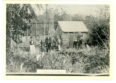
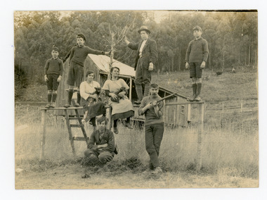
The Keoghs took up Lot 7 in the Village Settlement in 1905. John Keogh was a big Irishman and cleared many of the giant trees on his Lot 7. They had little water for their crops so grew gooseberries and red currants rather than the more valuable strawberries. Mrs Keogh (nee Cleary) inherited money in 1906 and they built a new weatherboard house. The original bush hut remained as the kitchen. Son James (Jimmie) married Mary Walsh, a teacher at the local school. Jimmie built the small shop on the triangle of land cut off when the CRB road went through. Jimmie and his wife left the district when he joined Victoria Police. Jimmie came back to the area and finally sold the land of Lot 7 to Rimington's Nurseries. He moved his family to Kilsyth. In 1939 the shop was moved across the road to be used as an office by the road builders. It burned down that year.Black and white photograph of a man, woman and young male standing outside a wooden hut. There are crop remnants in the foreground and a wooden paling fence behind the hut. A label on the front reads A SETTLER'S HUT. Reverse of photograph has handwritten description by John Lundy-Clarke.Front: A SETTLER'S HUT Reverse: 1905 Keogh's hut on Falls Road then Main Road. This was later the kitchen of their extended home as described in the narrative "Mountain of Struggle". The figures are - Mrs Keogh. John Keogh settler. Son James Keogh.keogh, john keogh, james keogh, jimmie keogh, mary walsh, cleary, shop, store, gooseberries, rimington's nursery -
 Mt Dandenong & District Historical Society Inc.
Photograph
In 1913 Edgar Dower took a photograph from this spot on Ridge Road that became known as Point Clear showing the Mt Dandenong township behind a stand of tall, dead trees. John Lundy-Clarke took this photograph from a similar spot at the Mt Dandenong Arboretum in 1975.Black and white photograph showing a cleared area in the foreground with young tress in the centre and hills in the distance. Several rooftops can be seen mid photo on the right. Reverse of photograph has handwritten description by John Lundy-Clarke.1975 View from the Arboretum over Mt D'nong township at the spot where Edgar Dower took the 1913 photo. The Falls gully is in the middle distance. Peter Damman's fence running downhill right foreground.edgar dower, point clear, mt dandenong, john lundy-clarke, peter damman, arboretum -
 Mt Dandenong & District Historical Society Inc.
Photograph
The people pictured are all members of the CHILD family and related to Francis Matthew Child, one of the earliest settlers. L-R back: L - R back – Bert (Hubert Child b. Lilydale 1913), Len (Leonard Child b. Lilydale 1915,), Ethel (Ethel May Child nee Madden married Ted Child), Marie (Marie Child nee Madden married Bert Child), Bert (Hubert Matthew Child b. 1882 Lilydale), John (Jack) (John Arthur Child b. Lilydale 1911). L - R front - Bernard (Bernie son of Ethel Madden before she married Ted Child), Percy (Charles Percival Child b. 1889 Lilydale he married Dorothea Lucas in 1917). The house pictured in the background belonged to Eva and Bert Court. Eva (May Eva Child b, 1880) married Bert (Bertram Court) in 1917. Black and white photograph showing six males and two females posed on a fence in front of a small, wooden house.On back: Taken Court's Eva and Bert. House in background. Child's Road Kalorama. Between 1925 - 1935.john child, percy child, bert child, len child, ethel child, marie madden, marie child, hubert matthew child, hubert child, bernie child, bernard child, charles percival child, eva court, bert court, bertram court, eva child, may eva child, ethel madden -
 Mt Dandenong & District Historical Society Inc.
Photograph
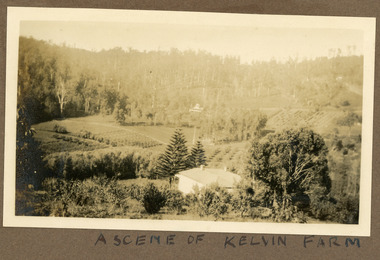
Most likely a scene of 'Mt Calvin', the homestead built by John William (Willie) Richardson for his wife Jeanie Green of Wandin. The house was built c1898 The Rowse family purchased the house and 60 acres when Willie and Jeanie Richardson with their 3 children moved to Brisbane. The Rowse family farmed the 60 acres for 35 years and the house was demolished in 1938. The photograph is from the album of Ivy May Child. Ivy May Child (1910 – 1989) was the daughter of Arthur Edward (Ted) Child (1878 – 1964) and Ethel May Madden (1888 – 1970). Ted Child was the son of Matthew Francis Child (1839 – 1933) and Martha Jeeves (1857 – 1926). He was the grandson of one of the early pioneers Francis Child. Ivy grew up on the family property on Childs Road and took many photographs. Most of these are glued into her photo album. The album covered the years from c1927 – 1932. Ivy married Henry William Burgess (1906 – 1968) in 1944. The photographs remain in their original state in the album with individual copies made. Black and white photograph with a house in the foreground looking over cultivated fields with treed hills in the background. A building is visible in the centre in the distance.Written below the photograph in the album" A SCENE OF KELVIN FARMmt calvin, kelvin farm, calvin farm, richardson, rowse, jeanie richardson, john william richardson, willie richardson -
 Old Colonists' Association of Ballarat Inc.
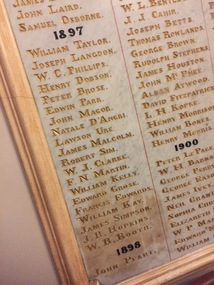
Photograph - Colour, Marble Honour Boards listing Benefactors to the Ballarat Old Colonists' Associations, 1897
Marble Honour Boards listing benefactors to the Ballarat Old Colonists' Associations. The name was added to the boards the year of the donors death. 1897 William Taylor joseph Langdon W.C. Phillips Henry Dobson Peter Brose Edwin Park John Magor Natale D'Angri Lawson Ure James Malcolm Robert Sim W.J. Clarke F.N. Martin William Kelly Edward Grose Francis Edwards William Kay James Simpson J.R. Simpson W.B. Boothwilliam taylor, joseph langdon, w.c. phillips, henry dobson, peter brose, edwin park, john magor, natale d'angri, lawson ure, james malcolm, robert sim, w.j. clarke, f.n. martin, william kelly, edward grose, francis edwards, william kay, james simpson, j.r. simpson, w.b. booth, old colonists' hall, old colonists' association -
 Old Colonists' Association of Ballarat Inc.
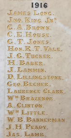
Photograph, Clare Gervasoni, Names on the Marbles at the Ballarat Old Colonists' Hall, 1916, 2020
Photograph of the names listed on the Marbles at the Ballarat Old Colonists' Hall for 1916old colonists' hall, old colonists' association of ballarat, marbles, james long, john king junior, g.a. brown, g.t. brown, c.e. house, g.t. jones, r.t. vale, j.g. tucker, h. baber, j. lammin, d. lillingstone, george becher, laurence clark, william brazenor, a. clinton, w.b. bannerman, j.h. peady, james lamb -
 Old Colonists' Association of Ballarat Inc.
Photograph, Clare Gervasoni, Names on the Marbles at the Ballarat Old Colonists' Hall, 1919, 2020
Photograph of the names listed on the Marbles at the Ballarat Old Colonists' Hall for 1919old colonists' hall, old colonists' association of ballarat, marbles, t.c. anderson, agnes murray, g. donaghy, f. opie, thomas bodycomb, harry d. davies, john clarke, r.l. medwell, g.n. robinson, isaiah pearce, a.r. tunbrisge, f.g. handford, f.g. fraser, f. carver, j.s. douglas, alfred deakin, t.j. mcconnell