Showing 3409 items matching "1893-1902"
-
 Greensborough Historical Society
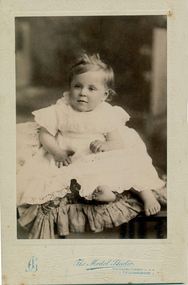
Photograph - Photograph - Digital Image, Betty Black, 1902c
Studio photograph of Elizabeth (Betty) Black, sister of Lindsay Black. The Black family were early landowners in Watsonia, from Grimshaw Street to Lambourn Road. The Model Studio operated from 330 Smith Street Collingwood from 1902-1904.Digital copy of black and white studio photograph.betty black, black family, elizabeth black, watsonia -
 Greensborough Historical Society
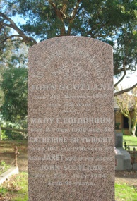
Photograph - Digital Image, Grave of John Scotland, Mary Colquhoun, Catherine Sievwright and Janet Scotland, Greensborough Cemetery, 21/11/1888
Grave of John Scotland (died 21/11/1888), Mary Colquhoun(died 15/02/1902), Catherine Sievwright (died 10/01/1910) and Jessie Scotland (died 21/07/1924 in Plot# M8/M9 Greensborough CemeteryGreensborough Cemetery was created when land was given for the cemetery by Mr William Poulter, a local settler, about 1864. The cemetery holds the graves of many early settlers in the district. Digital copy of colour photograph of grave/headstone.john scotland, mary colquhoun, catherine sievwright, janet scotland, greensborough cemetery -
 Greensborough Historical Society
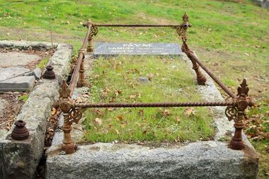
Photograph - Digital Image, Grave of Samuel Payne and Mary Payne, Greensborough Cemetery, 30/09/1892
Grave of Samuel Payne (died 30/09/1892) in Plot# G12 Greensborough Cemetery. RIP. Mary 1851-22/09/1926. Mary married Samuel Payne in 1867 (4138) she then married Frederick William Henniker in 1902 (2137).Greensborough Cemetery was created when land was given for the cemetery by Mr William Poulter, a local settler, about 1864. The cemetery holds the graves of many early settlers in the district. Digital copy of colour photograph of grave/headstone.samuel payne, greensborough cemetery -
 Glenelg Shire Council Cultural Collection
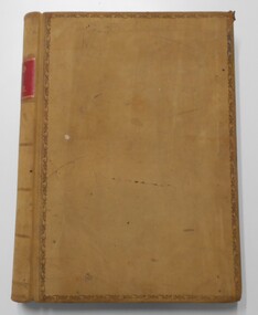
Book, George Alfred Henty, Dorothy's Double, 1894
Dorothy Hawtrey's life is turned topsy turvy by a rogue enemy who cultivates a poor girl who resembles Dorothy and uses her to impersonate Dorothy. The tale expands to the California gold fields where the double and her captor are eventually discovered. The double turns out to be a long lost sister, the rogue is killed, and all ends well.Dark brown leather bound spine and cover corners. Green cloth-covered board covers. Gold text on spine.fictionDorothy Hawtrey's life is turned topsy turvy by a rogue enemy who cultivates a poor girl who resembles Dorothy and uses her to impersonate Dorothy. The tale expands to the California gold fields where the double and her captor are eventually discovered. The double turns out to be a long lost sister, the rogue is killed, and all ends well.fiction, historical fiction, thriller -
 Bayside Gallery - Bayside City Council Art & Heritage Collection
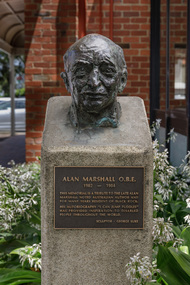
Sculpture - bust, George Luke, Alan Marshall, 1985
Alan Marshall (1902-1984) was an Australian writer, storyteller, social documenter and author of 'I Can Jump Puddles'. He lived for many years in Sandringham. This work was commissioned by Sandringham Council and unveiled in May 1985 at the opening of the new Sandringham library.George Luke, Alan Marshall 1985, bronze. Bayside City Council Art and Heritage Collection. Commissioned 1985Cast bronze head of Alan Marshall. The head is mounted on a cement pedestal with a bronze plaque with inscription at the front. Located at Sandringham Library, Corner Waltham Street and Chalmers Avenue, Sandringham.alan marshall, george luke, scultpure, portrait, bust, sandringham, library, writer, social documenter, australian author -
 Warrnambool and District Historical Society Inc.
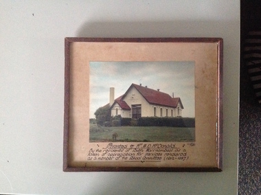
Photograph, South Warrnambool School, framed
The South Warrnambool Primary school No 1902 was opened in 1877 by the mayor at the time Cr J Cramond. The first teacher was Mrs Eliza Clarke. It catered for the children of the strong and closely knit community of South Warrnambool. The Mc Donald family was one of these families. A clear photograph of a school with which many past students would have fond memories. A contribution over 25 years to a primary school in this case by W D McDonald is a story of personal endeavour. It therefore has historical and social significance.Coloured photograph of the South Warrnambool State School framed with inscription written in black ink at bottom of coffee coloured mount.Presented to Mr W D McDonald by the residents of South Warrnambool as a token of appreciation for services rendered as a member of the School Committee (1912-1937) A Wilkins Photo. Stuart Mc Donald and Shirley written on back of frame mounting board.south warrnambool primary school, school number 1902, warrnambool history -
 Federation University Historical Collection
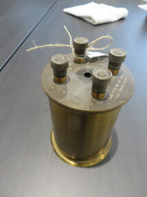
Scientific Instrument, Weston Normal Cell Coil
The Weston cell, is a wet-chemical cell that produces a highly stable voltage suitable as a laboratory standard for calibration of voltmeters. Invented by Edward Weston in 1893, it was adopted as the International Standard for EMF between 1911 and 1990.[1] This is a type of standard cell, which is a battery that produces a precisely known voltage in laboratory conditions at 20 degrees centigrade.[2]Brass cylinder with 4 connections at top. Two marked 'A' and the other two marked 'B'. Black plastic nob in the centre top. Written at top Weston Normal Cell I-0183 INT VOLTS AT 20 degrees CWeston Normal Cell H Tinsley & Co, London S E No 50498 No 8910weston cell, wet-chemical cell, stable voltage, voltmeters, edward weston, scientific instrument -
 Uniting Church Archives - Synod of Victoria
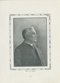
Printed image, Rev. A.R. Edgar, Undated c.1914
Alexander Robert Edgar 1850 - 1914. Methodist Minister. Served at Wesley Church Lonsdale Street for 21 years. Founded the Central Mission, and was Superintendent of the Mission 1893 - 1910. Edgar was the last President of the Wesleyan Conference of Victoria and Tasmania in 1901 and presided at the opening of the first United Methodist Session until Dr Fitchett was elected President.B & W profile portrait of the Rev. Alexander Robert Edgar, printed for publication. On the reverse is a photo of the Rev. A.R. Edgar memorial tablet in Wesley Church.Rev. A.R. Edgaralexander robert edgar, methodist minister, wesley church, central mission, president of the wesleyan conference, dr fitchett -
 Uniting Church Archives - Synod of Victoria
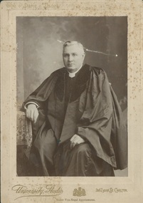
photograph, 1901
Alexander Robert Edgar 1850 - 1914. Methodist Minister. Served at Wesley Church Lonsdale Street for 21 years. Founded the Central Mission, and was Superintendent of the Mission 1893 - 1910. Edgar was the last President of the Wesleyan Conference of Victoria and Tasmania in 1901 and presided at the opening of the first United Methodist Session until Dr Fitchett was elected President.Sepia coloured three quarter seated portrait of the Rev. Alexander Robert Edgar dressed in his Presidential robes. Mounted on buff card.Rev. A.R. Edgaralexander robert edgar, methodist minister, wesley church, central mission, president of the wesleyan conference, dr fitchett -
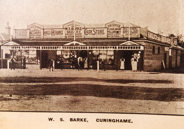 Lakes Entrance Historical Society
Photograph - Barke's Store, 1900c
This extensive weatherboard store was built in 1893 at a cost of one thousand pounds, architect was H French, builder McKnockiter Bros and D Collins the plasterer. William Barke managed the general store, bakery and hardware, brother John Barke managed the clothing and fancy goods department. Building was demolished and replaced by Centrepoint Arcade in 1985-1986Sepia coloured photograph of Barke's Store, people in front of store. Lakes Entrance VictoriaW S Barke, Cunninghameretail trade, people -
 Ballarat Heritage Services
Photograph - School site, Site of the former Kurting State School, 2016, 10/01/2016
The Kurting State School No 2353 opened in 1881. The name changed to Hope Creek State School in 1893 and then in 1928 became the Powlett State School. The school burnt down in 1944 with school being held in the hall until the end of 1945. In 1946, the children of the area were bused to Inglewood. [Kurting - 808, Kurting - 2026 and Kurting - 2353]A plaque indicating the site of the Kurting Primary School. Site of Kurting State School N0. 2026 1878 - 1947 Project of Loddon Shire Council 2-4-2000kurting, kurting state school, kurting primary school -
 Warrnambool and District Historical Society Inc.
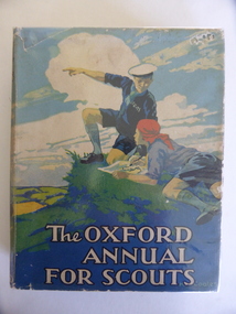
Book, The Oxford Annual for Scouts, 1927
This book was a prize given to Arthur Rogers in 1928. Arthur George (Bill) Rogers was the grandson of Joseph Rogers, a Warrnambool plumber and the son of Arthur and Agnes Rogers of Warrnambool. He worked in the advertising department of the Warrnambool Standard newspaper for nearly 50 years and died in 1995. It is presumed that the school that awarded the prize was South Warrnambool State School No. 1902. This school was established in 1877 with the first Head Teacher, Mrs Eliza Clarke. It was closed in 1994. The donor of the prize was South Warrnambool Football Club. This club was established in 1902 and has competed in the Hampden Football League since 1933. It is a successful club with many of its players going on to play in A.F.L./V.F.L teams. This book is of interest because of its 1920s connection to the South Warrnambool State School, the South Warrnambool Football Club and a local South Warrnambool resident, Bill RogersThis is a hard cover book of 196 pages. The cover is multi-coloured with an image of scouts on top of a hill with their encampment beneath. The lettering is white. The dust cover has the same illustration and is rubbed at the edges and partly torn away at the top left edge. It also shows some silverfish damage. It has a protective plastic cover. The book has one full page colour illustrations and many black and white illustrations and sketches. The book has 20 stories or articles. The inscription is handwritten in black ink.‘Grade IV First Prize Awarded to Arthur Rogers by the South Warrnambool Football Club December 1928 A.S.James Head Teacher’ south warrnambool state school, south warrnambool football club, bill rogers, south warrnambool -
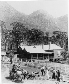 Halls Gap & Grampians Historical Society
Photograph - B/W, C 1880
1880-1902 Land owned by Robert and Sarah Graham who owned a large portion of land best described as Upper Fyans Valley. At some time after 1880, they sold a parcel of the land under Sundial Peak to David Austin who built a slab hut. C1896, The land was sold to James and Amy Balmain which they named 'Bellfield' Amy was a daughter of John D/Alton who built the Stawell Water Supply System. Balmain purchased the vacant school cottage at Burnt Bridge and moved it to 'Bellfield' Over the next six years the house was enlarged to accommodate their growing family but sold in 1902 following the death of Amy Balmain.House with addition People leaving house by horse and carriage, people standing in groundsState Library Victoria, Rose's Australasian Views Victorian Series photographed and published by George Rose 123 Chapel St., Windsor, Victoriabuildings, houses, bellfield -
Bendigo Historical Society Inc.
Programme - Program and Toast list, 1951
In 1890 Bendigo's first tramway battery-electric carriages operated between Sanhurst and Eaglehawk. In 1892 Battery-electrics were replaced by steam tram cars on the Bendigo Railway Station track to Eaglehawk. In 1903 Electric traction overhead was inaugurated extending to Quarry Hill, Golden Square and Lake Weeroona. In 1913 Open cross-seat cars added for the service Quarry Hill to Eaglehawk. In 1945 Traction bogie cars replaced older cars. In 1947 Birney safety cars (dead man controllers) replaced older carsToast list for a Bendigo Tramways Division Retirement Dinner - A complimentary Dinner tendered to Mr Arthur Douglas on his retirement after 31 years as Secretary of The Australian Tramway and Motor Omnibus Employees' Association. Held at the Shamrock Hotel, Bendigo Saturday 29th September 1951. Inside are two tramways photos, one of the Bendigo Steam trams 1902, and the other of trams passing through Charing Cross in 1951. On the last page is a program and menu for the event.history, bendigo tramways, evolution of bendigo tramways, arthur douglas, australian tramway and motor omnibus employees association -
 Bendigo Historical Society Inc.
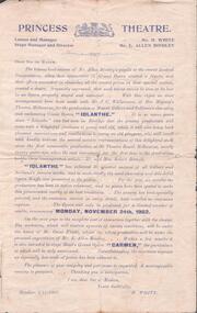
Document - EVA MAY CROWTHER COLLECTION: PRINCESS THEATRE PROGRAMME
Programme for comic opera ''Iolanthe'' commencing November 24th, 1902 at the Princess Theatre. Main actors: Mr. Alex Hamilton, Mr. S. Horwood, Mr. W. Cahill, Mr. E. Allen Bindley, Mr. R. Eddy, Mr. Tom Pritchard, Miss Beatrice English, Miss Eva Crowther, Miss Rose O'Mahoney, Miss Addie Campbell, Miss Else Crowther, Miss Rose Spargo, Miss Lillian Orchard and Miss Florence Quinn.program, theatre, princess theatre bendigo -
 Whitehorse Historical Society Inc.
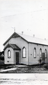
Photograph - Black & white photo, United Free Methodist Church
Used by donor in 'Blackburn - a picturesque history'Black & white photo of United Free Methodist Church built in 1888 in Chapel Street. Re-sited in 1902 to cnr. Whitehorse Road and Melvin Street, Ringwood.|The United Free Methodist began working in Blackburn in Sept 1888, when an allotment was presented to church by Blackburn Company. (Freehold Investment and Banking Company).|Original Church built by Mr. Williams - cost 200 pounds.|First service held in 1890. Page 65 of De Costa Book.united free methodist church, chapel street blackburn, blackburn methodists, freehold investment and banking company of australia ltd -
 Ballarat Tramway Museum
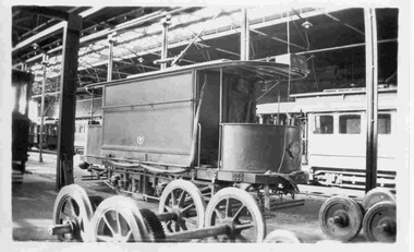
Photograph - Black & White Photograph/s, Keith Kings, Apr. 1949
Black and White photograph contained with Reg. Item 1902 - Photo Album from Keith Kings to Les Denmead 1970. Photograph of SEC Bendigo - original sprinkler and track cleaning tramcar at the depot, Easter Monday 4/1949. Photographed inside the depot with maximum traction driving wheels in the foreground. Other trams in the background. Keith Kings No. B(y)(6) Scanning: i - image file, p - presentation file, b - back of photograph.Stamp in top left hand corner and handwritten number with "K.S. Kings No. B(y)(6) Copyright reserved". In blue ink "Bendigo / The original Sprinkler and track cleaning car / Depot / Easter Monday / 4/49"trams, tramways, bendigo, sprinkler tram, track cleaner, scrubber tram, depot, tram sprinkler, tram scrubber -
 Stawell Historical Society Inc
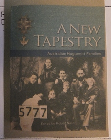
Book, Robert Nash, A New Tapestry – Australian Huguenot Families, 2015
Card Cover the teal band above a blue band Colourful badge with suspended White Dovebelow which is a B/W Photo of the George Delahoy Snr., with his wife Ellen Delahoy and their children Robert (2Weeks), Emma 13, (Standing behind), George Jnr. 12 (Standing Behind). Walter 3 ( on fathers knee). William 9 (Seated beside Mother). Heny 6 ( Standing by father). Photo taken at the Hindmarsh Hotel, Jeparit July 1902.A New Tapestry Australian Huguenot Families Edited by Robert Nash Inside in black Ink: with best wished R.J. Nashstawell -
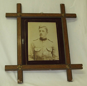 Stratford and District Historical Society
Photograph, Framed
The photograph that appears in this frame is a copy. The original is catalogued at 01314. Sgt David Hamilton Pruden, 404, enlisted from Newry and was killed at Koster River in the Trasnvaal on 21 July 1900, and was buried at Rustenburg cemetery. He is commemorated in a large tablet in the Stratford Mechanics' Institute. This photograph originally hung in the Stratford Mechanics' Institute. A framed sepia copy photographic print of a head and shoulders portrait of a young man in dress uniform of the Victorian Mounted Rifles, labelled Pte D.Pruden and presumed to be David Hamilton Pruden, who died in Africa during the Boer War. The frame, of crossed wooden bars with decorative metal at each crossing, appears to be commercially produced. Backing support for the frame is a section of an 1893 calender for an unknown insurance firm, agent J.B Kelly at Stratford, which has been detached for separate cataloguing.boer war 1899-1902 -
 Bendigo Historical Society Inc.
Document - LANDS OFFICE: CERTIFIED PLAN REGISTER
Document: hard cover journal. Buff cover with embossed edges. Spine has red insert with 'Certified Plan Register' printed in gold. 250 pages, with index in front of register. LH page: number, date of receipt, name, parish, tracing book, plan, decision of Board of land and works, gazette page, name of surveyors, date of survey, sent to, date. RH page: précis of minute. Dated 1878 - 1893, includes areas in central and northern Victoria.plan register, lands office, bendigo, plans, surveyed, victoria, northern victoria -
 Learmonth and District Historical Society Inc.
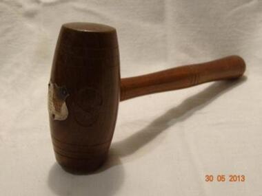
Gavel, Early 20th Century
This Gavel was used by Councilor Matthew J. Ryan during his various terms as Ballarat Shire President,He was first elected to council on 30th August 1897.serving as Shire President in 1902-08-14-23-32-38-44 and 50Tool used to "control" council meetings,by Shire President. Brown wooden object with handle to which is attached a barrel shaped head, on which is carved the initals BS.On the front of this is a silver shield name and dates.B.and S carved in wood.On silver shield,Shire of Ballarat, Cr.M.J.Ryan JP President.1902,1908,1914,1923,1933,1938,1944,1950.gavel.tool.councilor m j ryan -
University of Melbourne, Burnley Campus Archives
Slide - Glass slide, 1891-1905
Photograph by Johnson and Hoffman from the book "The Living Races of Mankind, A Popular Illustrated Account of the Customs, Habits, Pursuits, Feasts & Ceremonies of the Races of Mankind Throughout the World " by Henry Neville Hutchinson, Richard Lydekkert and John Walter Gregory first published in 1902 Photograph of two men in ceremonial outfit in Tibet early 1900.15.Living Races. Two Lamas of Nud in Ceremonial Dress.anthropology, china, men, living races of mankind, henry neville hutchinson, richard lydekkert, john walter gregory, lamas, tibet -
 City of Greater Bendigo - Civic Collection
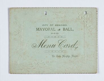
Memorabilia - Event Program, City of Bendigo, Mayor Ball, 1906
Luke Murphy served as a Councillor from 1902 - 1917 and was elected the 35th Mayor of Bendigo in 1905. The Mayor and Mayoress gave the customary ball at which over 400 guest attended and was regarded as one of the most successful in the municipals history. (p219 Mayors of Bendigo). Event program for the Mayoral Ball, 26th June, 1906. Gold and green ink on green card. Half fold with menu and drinks list printed inside.Embossed and scalloped edges.Front cover: City of Bendigo / 26-06-06 / Menu Card / Cr. Luke Murphy, Mayor bendigo town hall, making a nation exhibition, mayoral ball, mayor luke murphy, councillor luke murphy, milburn catering bendigo, cambridge printers, city of greater bendigo events, city of greater bendigo ceremonial item -
 Bendigo Historical Society Inc.
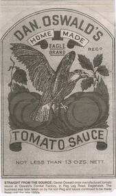
Newspaper - JENNY FOLEY COLLECTION: STRAIGHT FROM THE SOURCE
Daniel Oswald (1876-1947) married Louisa Trgonning (1878-1955) in 1902. They had the following family:- Lorna (1904-1920); David Sinclair (1905-1988); John Reginald (1909-1973); Daniel Dallas (1910-1966) and Dugdale (1919-1980)Bendigo Advertiser '' The way we were'' from 2002. Straight from the source: Daniel Oswald once manufactured tomato sauce at Oswald's Cordial Factory, in Peg Leg Road Eaglehawk. The business was later taken on by his son Reg and sauce continued to be made there until the late 1950s. The clip is in a folder.newspaper, bendigo advertiser, the way we were -
 Clunes Museum
Photograph
EARLY PHOTOGRAPH OF CLUNES SHOW. CLUNES AGRICULTURAL SHOW C1875 SHOWING JOHN FRANCIS PHILLIPS AND PROBABLY SON JOHN FRANCIS PHILLIPS. JOHN PHILLIPS WAS MAYOR OF BOROUGH 1892 - 93. 1902 - 03 1906 - 07 1913 - 14 1918 - 19.SEPIA PHOTOCOPY OF VERY EARLY CLUNES SHOW - DRAUGHT HORSES PULLING A FOUR WHEELED VEHICLE. TWO LADIES IN FOREGROUND, MAN AND SMALL BOY ALSO IN FOREGROUND IN EARLY COSTUMES, MANY PEOPLE IN BACKGROUND.photographs, events and celebrations, clunes show -
 Canterbury History Group
Photograph - Canterbury Grammar School, c1903
Pupils standing in the front of Canterbury Grammar School, corner of Alexandra Avenue and Canterbury Road. The school began in the Methodist Church Hall , Balwyn Road approx 1902, moved to Goldings Hall , and from1903 - 1913 operated from Alexandra Avenue, Canterbury Road.canterbury, canterbury road, alexandra avenue, canterbury grammar school, goldings hall, methodist church, independent schools students -
 Kew Historical Society Inc
Plan, Studley Park Estate, 1910
Prue Sanderson, in her groundbreaking ‘City of Kew Urban Conservation Study : Volume 2 - Development History’ (1988), summarised the periods of urban development and subdivisions of land in Kew. The periods that she identified included 1845-1880, 1880-1893, 1893-1921, 1921-1933, 1933-1943, and Post-War Development. These periods were selected as they represented periods of rapid growth or decline in urban development. An obvious starting point for Sanderson’s groupings involved population growth and the associated economic cycles. These cycles also highlighted urban expansion onto land that was predominantly rural, although in other cases it represented the decline and breakup of large estates. A number of the plans in the Kew Historical Society’s collection can also be found in other collections, such as those of the State Library of Victoria and the Boroondara Library Service. A number are however unique to the collection.The Kew Historical Society collection includes almost 100 subdivision plans pertaining to suburbs of the City of Melbourne. Most of these are of Kew, Kew East or Studley Park, although a smaller number are plans of Camberwell, Deepdene, Balwyn and Hawthorn. It is believed that the majority of the plans were gifted to the Society by persons connected with the real estate firm - J. R. Mathers and McMillan, 136 Cotham Road, Kew. The Plans in the collection are rarely in pristine form, being working plans on which the agent would write notes and record lots sold and the prices of these. The subdivision plans are historically significant examples of the growth of urban Melbourne from the beginning of the 20th Century up until the 1980s. A number of the plans are double-sided and often include a photograph on the reverse. A number of the latter are by noted photographers such as J.E. Barnes.Coloured lithograph of a subdivision plan of the Studley Park Estate, bordered by Yarra, Willsmere Road and the Outer Circle Railway line. The estate was listed in 1910 and was the subject of a planning dispute between the developer and the Town of Kew in relation to flood levels and the suitability of the land for housing. In many cases the names of streets were subsequently changed. The layout was also affected by the creation of the Eastern Freeway. A newspaper report of the day described the subdivision as a: "GOLDEN OPPORTUNITY. We are pleased to submit for PRIVATE SALE that magnificent ESTATE, situated only 4 1/2 miles from the Melbourne General Post Office, STUDLEY PARK ESTATE. KF/NV. Doubtless the CHEAPEST LAND EVER OFFERED having extensive frontages to the prettiest spot on the River Yarra and the National Park, commanding lovely river and landscape views, and acknowledged to be the finest land available so close to the city. The PRICES ARE EXTREMELY MODERATE; The TERMS ARE SIMPLY MARVELLOUS. NO DEPOSIT. NO DEPOSIT. NO DEPOSIT. Allotments and prices to suit everyone."subdivision plans - kew, studley park estate -
 Kew Historical Society Inc
Plan, Studley Heights Estate, 1936
Pru Sanderson, in her groundbreaking ‘City of Kew Urban Conservation Study : Volume 2 - Development History’ (1988), summarised the periods of urban development and subdivisions of land in Kew. The periods that she identified included 1845-1880, 1880-1893, 1893-1921, 1921-1933, 1933-1943, and Post-War Development. These periods were selected as they represented periods of rapid growth or decline in urban development. An obvious starting point for Sanderson’s groupings involved population growth and the associated economic cycles. These cycles also highlighted urban expansion onto land that was predominantly rural, although in other cases it represented the decline and breakup of large estates. A number of the plans in the Kew Historical Society’s collection can also be found in other collections, such as those of the State Library of Victoria and the Boroondara Library Service. A number are however unique to the collection.Subdivision plans are historically important documents used as evidence of the growth of suburbs in Australia. They frequently provide information about when the land was sold on which a built structure was subsequently constructed as well as evidence relating to surveyors and real estate and financial agents. The numerous subdivision plans in the Kew Historical Society's collection represent working documents, ranging from the initial sketches made in planning a subdivision to printed plans on which auctioneers or agents listed the prices for which individual lots were sold. In a number of cases, the reverse of a subdivision plan in the collection includes a photograph of a house that was also for sale by the agent. These photographs provide significant heritage information relating house design and decoration, fencing and household gardens.The ‘Studley Heights Estate’ on the South Side of Studley Park Road was launched in 1936. The seventeen allotments in the subdivision fronted Hyton Crescent and Studley Park Road.subdivision plans - kew, studley heights estate -
![Monnington [Estate], 1935](/media/collectors/550653872162f11fb04854aa/items/5907eb86d0ce0c14e82385c8/item-media/5907ecafd0ce0c14e823e87f/item-fit-380x285.jpg) Kew Historical Society Inc
Kew Historical Society IncPlan - Subdivision Plan, Monnington [Estate], 1935, 1935
Pru Sanderson, in her groundbreaking ‘City of Kew Urban Conservation Study : Volume 2 - Development History’ (1988), summarised the periods of urban development and subdivisions of land in Kew. The periods that she identified included 1845-1880, 1880-1893, 1893-1921, 1921-1933, 1933-1943, and Post-War Development. These periods were selected as they represented periods of rapid growth or decline in urban development. An obvious starting point for Sanderson’s groupings involved population growth and the associated economic cycles. These cycles also highlighted urban expansion onto land that was predominantly rural, although in other cases it represented the decline and breakup of large estates. A number of the plans in the Kew Historical Society’s collection can also be found in other collections, such as those of the State Library of Victoria and the Boroondara Library Service. A number are however unique to the collection.Subdivision plans are historically important documents used as evidence of the growth of suburbs in Australia. They frequently provide information about when the land was sold on which a built structure was subsequently constructed as well as evidence relating to surveyors and real estate and financial agents. The numerous subdivision plans in the Kew Historical Society's collection represent working documents, ranging from the initial sketches made in planning a subdivision to printed plans on which auctioneers or agents listed the prices for which individual lots were sold. In a number of cases, the reverse of a subdivision plan in the collection includes a photograph of a house that was also for sale by the agent. These photographs provide significant heritage information relating house design and decoration, fencing and household gardens.The first subdivision of Monnington took place in 1935. At that time, Monnington and 10 new allotments were offered for sale bordering Adeney and Marshall Avenues. In this subdivision plan, Monnington is one of 13 lots for sale. The subdivision created the irregular land holding of Monnington today. The excision of southwest corner of Monninton was caused by the need to have regular allotments facing the curve in Marshall Avenue.monnington - adeney avenue -- kew (vic.), subdivision plans -- kew (vic.) -
 Kew Historical Society Inc
Plan - Subdivision Plan, Goldthorns House Estate, 1940
Pru Sanderson, in her groundbreaking ‘City of Kew Urban Conservation Study : Volume 2 - Development History’ (1988), summarised the periods of urban development and subdivisions of land in Kew. The periods that she identified included 1845-1880, 1880-1893, 1893-1921, 1921-1933, 1933-1943, and Post-War Development. These periods were selected as they represented periods of rapid growth or decline in urban development. An obvious starting point for Sanderson’s groupings involved population growth and the associated economic cycles. These cycles also highlighted urban expansion onto land that was predominantly rural, although in other cases it represented the decline and breakup of large estates. A number of the plans in the Kew Historical Society’s collection can also be found in other collections, such as those of the State Library of Victoria and the Boroondara Library Service. A number are however unique to the collection.The Kew Historical Society collection includes almost 100 subdivision plans pertaining to suburbs of the City of Melbourne. Most of these are of Kew, Kew East or Studley Park, although a smaller number are plans of Camberwell, Deepdene, Balwyn and Hawthorn. It is believed that the majority of the plans were gifted to the Society by persons connected with the real estate firm - J. R. Mathers and McMillan, 136 Cotham Road, Kew. The Plans in the collection are rarely in pristine form, being working plans on which the agent would write notes and record lots sold and the prices of these. The subdivision plans are historically significant examples of the growth of urban Melbourne from the beginning of the 20th Century up until the 1980s. A number of the plans are double-sided and often include a photograph on the reverse. A number of the latter are by noted photographers such as J.E. Barnes.The first subdivision of Goldthorns created the Goldthorns Hill Estate. Following that subdivision, seven additional lots were offered between Normanby Road, Argyle Road and Lady Loch’s Drive on the proviso that the estate, including Goldthorns was not sold as a single lot. The subdivision plan advises that the lots are situated in one of the most charming and popular residential areas in Kew and is surrounded by modern homes. Typically, the subdivision plan proposes the advantage of its proximity to Cotham Road and the tram to Collins Street. Because of the elevation of Goldthorns, much is made of the ‘bright, sunny and extensive outlook to the Northern Ranges’ and that it overlooks the Yarra Valley. One of the more interesting aspects of the plan is that it shows the outline of Goldthorns in the mid to late 1920s. Its profile today remains virtually the same."Goldthorns" House Estate at topsubdivision plans - kew, goldthorns house estate