Showing 41587 items
matching public-buildings
-
 Phillip Island and District Historical Society Inc.
Photograph, c 1900
Two storey hotel fronting road, behind withe picket fence, wrought iron filigree on both stories, gabled roofing, grey and white striped awning from roof. Attic on top of building. Two short chimneys front, two large on either side. Side buildings to left of photo. Walking man at front gate.Two storey Victorian Hotel - Bergins Hotel San Remolocal history, photography, photographs, slides, film, bergins hotel san remo, black & white photograph, miss elms san remo -
 Greensborough Historical Society
Photograph - Digital image, Marilyn Smith et al, Janefield Precinct: Dug in building site, 27/11/2014
Janefield Precinct: Dug in building site. The remains of this site are between Greensborough and Janefield. A RAAF Hygiene Training Camp was located on the Plenty River, just south of the Janefield community. It was in use from 1944 to 1946. The Camp was constructed from salvaged materials. Instruction included building and maintenance of grease traps, latrines, elementary plumbing and carpentry.Early remains of a WW2 training camp Digital colour photograph. -
 Eltham District Historical Society Inc
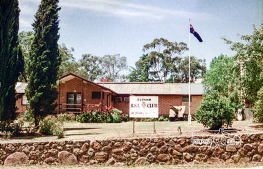
Photograph, Eltham RSL and Uniting Church, Main Road, Eltham, 1979c
Once a row of shops wase situated here and then the Eltham RSL sub branch occupied this site from the 1950s. The War Memorial obelisk was relocated here from it oriiginal site and situated in front of the building. After the branch amalgamated with Montmorency in 2012, the building was subsequently sold and demolished. The memorial was relocated. Units now occupy the site. Changing streetscapeRoll of 35mm colour negative film, 6 stripsUnidentified; half-frame numberingmonuments, church, eltham rsl sub-branch, eltham uniting church, main road -
 Stawell Historical Society Inc
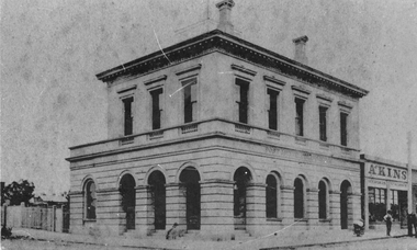
Photograph, Stawell Post Office Cnr Wimmera and Main Streets 1875
Stawell Post office built in March 1875 replacing the 1860 weather board building in the early Township of Stawell. The stucco exterior was described as modern Italian, and the building had excellent proportions. Special reference was made to the use of slate from Great Western. The foundations are of solid granite. The difference in this photograph to 85.01 would be approximately 100 years. Stawell Post Office possibly before 1880's on Corner of Wimmera and Main Street. Man on right of photograph standing in front of Akins Seed and Stationers Store near telegraph pole and horse. stawell -
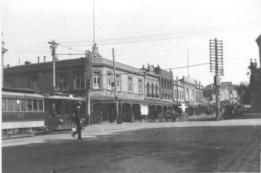
 Ballarat Tramway Museum
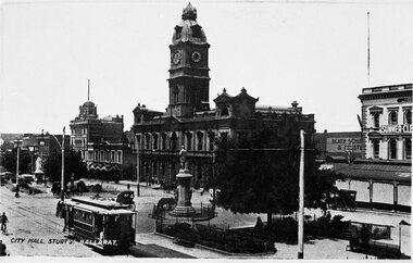
Postcard - Reproduction, City Hall Sturt St Ballarat - C1910
Image is of an ESCo tram just to the west of the Armstrong and Sturt St. intersection with the Ballarat Town Hall and the National Mutual building in the background. Tram travelling east. Tram has a destination box on the roof, but no drivers windows, say 1906 - 1912 or 1910c. Some horse drawn vehicles in the image. Snows has a "Summer Clearance" sign on the building. Yields information about Sturt St and ESCo trams c1910B&W print and scanned images of a postcard lent to the BTM by Mr. Norm DePomeroy, Dec. 1997.trams, tramways, sturt st, tram 5, esco, town hall -
 Ballarat Tramway Museum
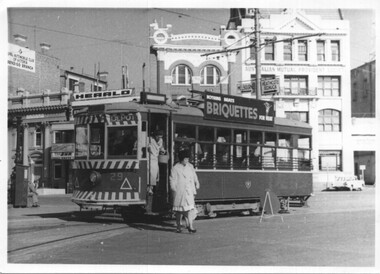
Photograph - Bendigo - Birney 29 Charing Cross, Jim Seletto, 25-9-1961
Photo shows Birney 29 at Charing Cross with the destination of Depot. Tram has a briquette advertisement. Two ladies are alighting. In the background are signs or buildings for the RACV, the Herald newspaper, and the Australian Mutual Provident building. Photo has date of 25 Sep 1961. Photo by Jim Seletto. Note the direction signs on the pole behind the tram.Yields information about Bendigo tram 29 and Charing Cross.Photograph - Bendigo - Birney 29 Charing CrossHas photographer, date stamp and location written on reartramways, tramcars, birney tramcars, tram 29, charing cross, bendigo -
 Kew Historical Society Inc
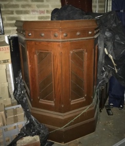
Furniture, Wooden Court Room Witness Box, 1880s
Witness Box, sourced during the period of renovation of the Kew Court House, believing that it was an original item of furniture from the building. Based on an examination of the woods in the item by heritage consultants, it was deemed not to be original to the building. As the item had been donated, the item could not be returned. For many years, it has been stored in teh basement of Kew Library.An original witness box from a Victorian Court House.Large and heavy wooden witness box from a Victorian court house.kew court house, court house furnishings -
 Sunbury Family History and Heritage Society Inc.
Photograph, Beechworth Chinese Cemetery, 1988
While the children were on their Beechworth Camp they visited the Chinese Cemetery in that town. The two grey buildings with the red roofs buildings are the ovens used for cremations and the altar is in the centre. The ovens were erected in 1857 and the altar was added between 1883-84. A number of Chinese came to the area seeking gold after the main gold rushes in the early 1850s.The existence of the Chinese Cemetery at Beechworth is an indication of the many different races of people arrived in Victoria own the 1850s seeking gold and spread across the Colony. A non-digital coloured photograph of a Chinese Cemetery Showing the ovens and the altar with the graves in rows behind.beechworth chinese cemetery, school camps -
 Ballarat Tramway Museum
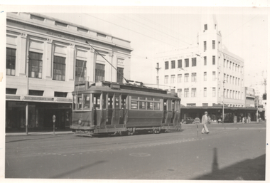
Photograph - Tram 23 in Ryrie St Geelong, Keith Kings, Jan. 1955
The photo shows Geelong tram 23 (EAST) in Ryrie St at the corner with Moorabool St. The photographer notes that the tram is in its unconverted format. In the background is the T&G building and Belcher's Corner building. A Safety Zone sign is in the view by the pedestrian. Photo by Keith Kings 8/1/1955, photo number L(l)(3)Yields information about Geelong 23 and Ryrie St.Black and white photograph with notes on rear.See rear image and context.trams, tramways, geelong, ryrie st, tram 23, moorabool st -
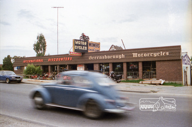 Eltham District Historical Society Inc
Negative - Photograph, Industrial development, Para Road, Briar Hill, c.1984
Views of industrial sites and shop fronts on Para Road, Briar Hill including the business 'Greensborough Motorcycles'. Para Road, Briar Hill is parallel to the Hurstbridge Railway Line. The building 'Greensborough Motorcycles' was destroyed by fire in the early 2000s. Signage on building includes: 'Greensboröugh Motorcycles', 'International Discounters', 'Motor Cycles', and 'Mowers & Chainsaws' and 'Hutchinson's'.Roll of 35mm colour negative film, 4 stripsKodak CP 100 5094briar hill, greensborough, greensborough motorcycles, hutchinson's, industry, international discounters, para road, business, vw beetle -
 Melbourne Tram Museum
Photograph, Cable tram 383 Bridge Road Richmond, 1910s
The photograph shows cable, trailer 383 in Bridge Road Richmond inbound to the City about to cross Church Street. G. Sterling & Sons, draper and outfitters establishment of Richmond since 1860 on this site with their 1897 building in the background. The building remains and in 2024 is a Commonwealth Bank. Photo possibly taken c1920 as cable tram appears to be in a MMTB livery.Yields information about cable trams in Bridge Road Richmond and associated buildings.Photograph, black and white, Kodak paper.trams, tramways, cable tram, tram 383, bridge road, church st, richmond -
 Melbourne Tram Museum
Photograph - Z23 Flinders St - Swanston St, late 1980s
Photo of Z23 (East Burwood, route 75) in Flinders St just before crossing Swanston St. The tram has The Met logos, a Fox FM radio station. In the background is the Port Phillip Arcade buildings. These buildings were demolished for the Metro Rail Project during 2017-2018. Photo taken from Princes Gate Plaza.Yields information about Melbourne trams late 1980s.Colour photograph with paper parts on rear.melbourne, tramways, tramcars, flinders st, z class, tram 23, route 75, trams -
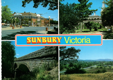 Sunbury Family History and Heritage Society Inc.
Postcard, Newcolourvue Productions Pty.Ltd, Sunbury Victoria, c1970s
The four photographs on the post card are well-known places in the town. They are the 1930s Royal Hotel building which was build on the same site of the original building on the corner of Evans and Brook Streets, Rupertswood Mansion, built 1874-45, the historic bluestone road bridge over Jacksons Creek and a view of the township in the 1970s taken from Francis Boulevard.The four views of Sunbury give an overview of the township in the 1970s before the increased development took place from the 1980s onwards.A coloured collection of four non-digital photographs of places in Sunbury in post card format. The edges of the post card are rippled. the back of the card gives details of the places as well as the maker.Sunbury Victoriaroyal hotel, rupertswood mansion, bluestone road bridge, sunbury, post cards -
 Eltham District Historical Society Inc
Photograph - Digital Photograph, Marguerite Marshall, Eltham Library, Panther Place, Eltham, 18 April 2008
Rear view of Eltham Library showing loading dock and ramp to the front of the building. Designed by multi-award winning architect, Gregory Burgess, for which he won the 1995 Royal Australian Insitute of architects (Vic.) Merit Award in the New Institutional category. Covered under Heritage Overlay, Nillumbik Planning Scheme. Published: Nillumbik Now and Then / Marguerite Marshall 2008; photographs Alan King with Marguerite Marshall.; p183 Award-winning Eltham Library, with its earthy tones blending into the nearby parklands, celebrates some of the best of Eltham’s spirit. Designed by multi-award winning architect, Gregory Burgess, the library at Panther Place, won him the 1995 Royal Australian Institute of Architects (Vic) Merit Award in the New Institutional category.1 The design is typical of Burgess’ work, emphasising natural materials and forms, and the integration of building and site.2 In its distinctive architectural character, Burgess celebrated the spirit of Eltham’s artist/architect Justus Jörgenson and mud-brick builder Alistair Knox. However this library, which opened in 1994, follows decades of efforts to acquire a suitable library for local residents. It was only in 1971 that Eltham acquired its first purpose-built library. In the 1930s books were borrowed from a mobile library run by Mr Foster of Bible Street. From the 1930s to the early 1950s, adults borrowed books from the newsagency and general store in Main Road (still a newsagency) near Arthur Street. As late as the 1950s, adults borrowed books in the shire office foyer, then in Main Road near the corner of Arthur Street.3 In the early 1950s the ratepayers voted for lower rates rather than a library, in a referendum to build a public library financed by higher rates. Children depended on volunteers for their library service until 1966. In 1946 the inaugural meeting of the Eltham War Memorial Trust’s Women’s Auxiliary, decided to support the Trust by raising funds to buy land and build a Children’s Library, Baby Health Centre and other facilities. The auxiliary formed the Children’s Library Committee, which included Mrs Morrison, Mrs Bow and Mrs Currie. They ran a library service in the stage area of the Eltham Hall, at the corner of Arthur Street and Main Road. In 1952 the books were relocated to a room in the newly opened Baby Health Centre on Main Road. Then in 1961, the Children’s Library received its own hall beside the Eltham Pre-School Centre on Main Road. From there, each month, volunteers delivered books to every school in the shire. In 1966 the Children’s Library closed after 17 years of service, following the transfer of the Trust land and buildings to the Shire of Eltham. The books were donated to nine schools in the shire and to Community Aid Abroad. An important boost to the library service came in 1965, when the Heidelberg Regional Library Service was formed by the City of Heidelberg with the Shires of Eltham and Diamond Valley. Its first library service for Eltham Shire was a bookmobile van. Books for children and adults were finally housed in one building in 1966, when the shire converted the Brinkkotter house in Dudley Street, into a library. At last in 1971, the Eltham Library moved to new premises attached to the shire offices near Panther Place. However these were demolished in 1996, by State Government appointed commissioners during council amalgamations. Meanwhile the Heidelberg Regional Library Service was disbanded in 1985 and the Yarra Plenty Regional Library Service was established. The burgeoning population brought pressure for a bigger library. Eltham was one of several municipalities in the 1970s and 1980s, battling with the State Government for adequate funding for public libraries. Funds were so tight, that in 1987 Eltham councillors threatened to close the library. However public petitions persuaded them to set aside funds to replace the cramped library facilities. In 1992 the Federal Government gave $887,496 towards the $3 million cost of the 1560 square metre library.4 The result is a light and spacious building with surrounding verandas, made of sustainable natural materials including earth and recycled and radially sawn timbers. It includes a gallery and function areas. In 2004 Mr Burgess won Australian architecture’s highest accolade: the Royal Australian Institute of Architects Gold Medal. He has received more than forty professional and community awards.This collection of almost 130 photos about places and people within the Shire of Nillumbik, an urban and rural municipality in Melbourne's north, contributes to an understanding of the history of the Shire. Published in 2008 immediately prior to the Black Saturday bushfires of February 7, 2009, it documents sites that were impacted, and in some cases destroyed by the fires. It includes photographs taken especially for the publication, creating a unique time capsule representing the Shire in the early 21st century. It remains the most recent comprehenesive publication devoted to the Shire's history connecting local residents to the past. nillumbik now and then (marshall-king) collection, eltham, eltham library, panther place -
 Eltham District Historical Society Inc
Photograph - Digital Photograph, Alan King, Kangaroo Ground Presbyterian Church, 28 December 2007
Built in 1878, the orange polychromatic brick structure replaced a slab building which had been used since 1951. The building has changed little with its handsome bricks buttressed on both sides, a slate roof and a Celtic cross on top of the front gable. The carved wooden pulpit and 18 pews are original. The cathedral-style ceiling is fully lined with tongue-and-groove pine boards and the floor is also pine. The walls have arched oblong leadlight windows. In 1977 the congregaton decided not to join the Uniting Church, whcih amalgamated some Presbyterian churches with all the Methodist and Congregational churches in Australia. Together with the store and school, the church is one of Kangaroo Ground's three public buildings. Covered under Heritage Overlay, Nillumbik Planning Scheme. Published: Nillumbik Now and Then / Marguerite Marshall 2008; photographs Alan King with Marguerite Marshall.; p91 The small Presbyterian church in Main Road, Kangaroo Ground, has been a spiritual centre for more than a century. Built in 1878, the orange polychromatic brick structure replaced a rude slab building, which had been used as both a church and school since 1851. Earliest settlers, who were Scottish farmers, had worshipped together since 1841 in a barn owned by farmer James Donaldson and led by a layman called Smith.1 However, from 1843, the Reverend Peter Gunn conducted church services. Prominent early church members include the Donaldson, Bell and Cameron families. In 1851, Samuel Furphy (father of author Joseph) built their first church building, a 30 feet x 18 feet (9m x 5.5m) slab structure on half an acre (0.2ha) donated by Mr Donaldson. Conditions could be very uncomfortable in extreme weather.The green slabs of timber and sapling logs, covered partly with mud, had centimetre-wide cracks, allowing rain and wind through, when not blocked out by folds of paper.2 However this did not deter the first couple marrying there in 1857: John Wilson of Nillumbik and Christina Macpherson of Christmas Hills. The Reverend Peter Gunn seldom visited so it was usually left to Andrew Ross, the settlement’s first teacher and founder of the newspaper The Evelyn Observer, to lead the divine services instead.3 In 1877 the settlers raised £355/19/- and hired architect, Charles Maplestone and builder, Mr Self, to construct today’s church building. Each family rented a pew or pews for ten shillings a half-year; they also paid quarterly subscriptions for the minister’s stipend.4 It was not until 1886 that the church celebrated its first wedding, that of John Bell (junior) from Violet Bank and Elizabeth Charlton of Cunis Nillen. The Sunday School’s first recorded meeting was also held that year. In 1892 a weatherboard vestry was built, and the following year John Bell donated a church bell, which the fire brigade used as a warning for several years. Conditions have varied greatly during the century. In 1893 the Reverend Darroch had to travel more than 2000 miles (3220km) to attend to his scattered parishioners. Then in the Depression, the minister Mr Brown, subsisted only on lodgings with no stipend. The Sunday School ceased for many years because of the small population, but reopened in 1949. The building has changed little with its handmade bricks buttressed on both long sides, a slate roof and a Celtic cross on top of the front gable. The carved wooden pulpit and 18 pews are original and in fine condition. The cathedral-style ceiling is fully lined with tongue-and-groove pine boards and the floor is also of pine. The walls have arched oblong leadlight windows. One window has stained glass commemorating Mrs Jessie Agnes Cameron and her ancestors – the pioneering Bell family. It depicts The Sower because the family comprised farmers who came to a strange land to sow the seeds of their faith as much as their crops. Thistles signify their Scottish ancestry and the pigeons are a symbol of Pigeon Bank, the Kangaroo Ground farming property where Jessie Cameron was born.5 Other historical ties are seen on two marble memorial tablets and carved wooden chairs dedicated to former members. The Church still has the original Bible with gold edged paper, presented by the women of the congregation in 1871, although it is no longer used. In 1977 the Presbyterian congregation decided not to join the Uniting Church, which amalgamated some Presbyterian churches with all the Methodist and Congregational churches in Australia. Together with the store and school, the church is one of Kangaroo Ground’s three public buildings.This collection of almost 130 photos about places and people within the Shire of Nillumbik, an urban and rural municipality in Melbourne's north, contributes to an understanding of the history of the Shire. Published in 2008 immediately prior to the Black Saturday bushfires of February 7, 2009, it documents sites that were impacted, and in some cases destroyed by the fires. It includes photographs taken especially for the publication, creating a unique time capsule representing the Shire in the early 21st century. It remains the most recent comprehenesive publication devoted to the Shire's history connecting local residents to the past. nillumbik now and then (marshall-king) collection, kangaroo ground presbyterian church -
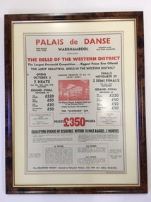 Warrnambool and District Historical Society Inc.
Document - Palais de Dance Warrnambool, 1954
Warrnambool’s first Palais was established in the Hotel Mansions on the corner of Koroit and Kepler Streets and destroyed by fire in 1929. The second Palais was established at the Liberty Theatre in Lava Street. The third Palais was established in the Oddfellows Hall building in Koroit Street in 1939. Dances were held weekly and sometimes more often and attracted musical talent from the Warrnambool district and even from Melbourne with band leaders such as Tommy Davidson and Vin Mills. In 1974 the Warrnambool City Council bought the building and it was used only intermittently for entertainment purposes. Today the building is in private hands and is used for commercial and business purposes. This advertisement is of considerable significance as it comes from the Palais de Danse dance theatre which was important as a social institution in Warrnambool for over 30 years. The advertisement also reminds us of the era (1940s, 50s, 60s) when beauty pageants and Belle of the Ball competitions were popular all over Australia. This is a document in a brown plastic frame with a gold-coloured metal inside edging. The frame has a glass front. The document is a 1954 advertisement for the Palais de Danse dance floor in the Oddfellows Hall in Koroit Street, Warrnambool. The advertisement has black and red printing on a buff-coloured background. The advertisement has an ornamental edge around the printing and a red-coloured photograph of the dance floor. ‘Palais de Danse, Warrnambool, proclaims The Belle of the Western District, The Largest Provincial Competition, Biggest Prizes Ever Offered, The Most Beautiful Girls in the Western District’ etc etcpalais de danse, warrnambool, beauty pageants, warrnambool -
Glen Eira Historical Society
Article - Maysbury, Maysbury Avenue, 1, Elsterwick
An article in Melbourne Bayside Weekly, October 20, 2010 by architect Neil Clerehan giving the history of Maysbury and describing some of its architectural features, also a description of the building and grounds subdivision into individual houses in the newly created Maysbury Avenue and the building into seven individual flats and subsequent addition of seven more apartments. Included in the article are three coloured photographs of one of the exterior of the building and two of individual rooms in apartment No.7. Also three real estate advertisements including three coloured photographs, one of interior of apartment and two external views of Maysbury dated 2009 and 2010.maysbury, elsternwick, maysbury avenue, south road, labassa, gatsby, burreel avenue, grimwade house, glenhuntly road, glenmayne, biggin and scott real estate, mansions, architectural features, flats, bedrooms, living rooms, kitchens, bathrooms, arches, ceilings, fireplaces, architects, land titles, gardens, sheds, victorian style, italianate style -
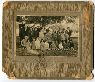 Orbost & District Historical Society
Photograph - Jarrahmond School & pupils c.1914
The Jarrahmond State School No. 2745 near Orbost was one of the earliest in this district. It opened in 1886 at the same time as Orbost and shared a teacher (Campbell McKay who was shortly afterwards replaced by John Rowe who stayed in this position until 1908). The building was financed and built by local farmers on the Stapley property. After a large and damaging flood in the nearby Snowy River in 1893 , the building was shifted to a new location. In 1926, a new building was constructed by the Vic Ed Dept. where it remained until the school was closed in 1948 and children from the Jarrahmond area were then bused to Orbost. Historical significance as one of the earliest photos of Jarrahmond School students.A b/w photo of a group of children and one adult in front of a tree. Children in the front are sitting on the ground, others are standing behind. Photo is mounted onto brown cardboard. On back of photo: Jarrahmond School c.1914. Sally Cole, Angus Cole.education, jarrahmond school, orbost -
Glen Eira Historical Society
Document - National Trust Register
This file contains two items relating to historic buildings in Glen Eira listed on the National Trust Registry: 1/A fax, sent to Gladys Vallati on 02/03/1995 from the National Trust of Australia listing buildings on the Trust’s registry in the Glen Eira area, as well as their addresses and status on the register (5 pages). (Additional photocopy taken for preservation purposes). 2/A typed list of buildings in the Glen Eira area (mainly Caulfield) which are on the National Trust list, including address, approximate date of construction and status on the register. Date of production of the list is unknown. (6 pages).neerim road, poplar grove, avoca grove, balaclava road, orrong road, bambra road, glen eira road, hood crescent, hawthorn road, glenferri street, glenhuntly road, glen huntly road, kambrook road, kooyong road, lirrewa grove, manor grove, north road, pearson avenue, seymour road, alma road, craddock avenue, dandenong road, lyndoch avenue, orrong crescent, hotham street, nagle avenue, inkerman street, iknerman road, sandham street, selwyn street, st. georges road, willow street, grange road, station place, railway parade, alexandra street, wood crescent, elizabeth street, halstead street, mavho street, tucker road, mckinnon road, nepean highway, wheatly road, uniting church carnegie, athole, st stephen's uniting church caulfield, st aloysius' catholic church, halstead, st mary's anglican church caulfield, caulfield town hall, anseln, the glen, woolamai, caulfield house, caulfield hospital, lirrewa, labassa, fairfield hall, bellecourt, bagatelle, myoora, rosecraddock, adam and eve - karl duldig, the family - karl duldig, caulfield primary school, septimus miller memorial chapel, brighton cemetery, hopetoun gardens, state savings bank elsternwick, anderson organ, hopetoun private hospital (melrose), rippon lea, ripponlea, burreel, o'neill college, lisbon house, elsternwick club, merkin-schutze organ, presentation convent, duldig mural - kadimah cultural centre, glenmoore, craigellachie, st james the great, glenfern, grimwade house, dacre, trinity congregational uniting church glenhuntly, alnwick, holmwood, new alexandra, joscelyne organ, smith organ, fincham organ, st george's bentleigh, mckinnon progress hall, wurlitzer organ, moorabbin town hall, christ anglican church, st mary's jubilee school, st stephen's presbyterian church, elsternwick congregational church, st mary's church of england, former metropolitan fire brigade station no. 31, st mary's jubilee church, belle court, trinity congregational church, heatherbrae, carnegie, caulfield, caulfield north, caulfield south, elsternwick, glen huntly, glenhuntly, murrumbeena, st kilda east, bentleigh, mckinnon, moorabbin, ormond, national trust of australia, national trust register, houses, churches, schools, organs, vallati gladys, mansions -
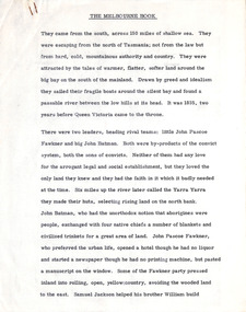 Robin Boyd Foundation
Document - Manuscript, Robin Boyd, The Melbourne Book, 1966
Description of first grid drawn of Melbourne by Robert Hoddle and design impetus; naming of gridiron streets; Charles Troedel prints/The Melbourne Album, F. Cogne drew Melbourne scenes on lithographic stones; Harold Freedman drew same scenes of Melbourne 1964/65; comparative discussion of Melbourne then and now; between 1865-1965 substantial buildings erected and demolished; cable tram; strength and delicacy of Melbourne style; first tree planting; first electric tram 1927; lifting of building height limits 1956; list of representative buildings; Melbourne unlike other capitals as it was not conceived as a capital city.Published as a chapter titled 'The Town at Port Phillip' in 'The Book of Melbourne and Canberra', The Griffin Press, Adelaide 1966Typewritten (c copy), quarto, 14 pagesjohn batman, john fawkner, robert russell, robert hoddle, charles troedel prints/the melbourne album, f. cogne; cable trams; building height limits; tree planting; electric tram 1927; representative buildings, robin boyd, manuscript -
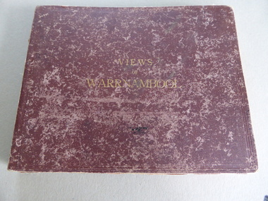 Warrnambool and District Historical Society Inc.
Album, Photographs Views of Warrnambool, c 1891
This album contains photographs of many Warrnambool buildings and scenes, including Proudfoot Boatsheds, St. John’s Church, Christ Church, Shelly Beach, Hopkins Falls, Sherwood gardens and buildings, Ozone Coffee Palace, Kepler Street, Sandstone Quarries and the Titan Crane on the Breakwater. The photographs have been taken and put in album form by the photographer Joseph Jordan. The advertisements of the hotels on the inside covers place the publication of the album to the years1891-2. We have another album similar to this but there are six photographs in this album (VC000799) that are not in the other album. These extra photographs are of the original gardens and buildings of Sherwood.This is a most important album as the photographs are clear and show a good cross-section of Warrnambool in the early 1890s. Some of the photographs are not represented in other collections (eg Sherwood gardens) and so are of vital historical significance. The advertisements are also of great use to researchers.This album has a brown hard cover and contains three pages of local advertisements and sixteen pages of photographs and 32 photographs back to back. The pages have been bound but some pages have come loose. There is a fold-out section of a 180 degree panorama of Warrnambool taken from Liebig Street hill. The edges of these pages have been taped.Front Cover- Views of Warrnamboolwarrnambool, views of warrnambool, photos of warrnambool -
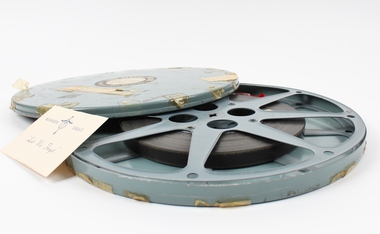 Melbourne Legacy
Film, Junior Legacy, 1959
A film of the 1959 rehearsal for Junior Legatee Demonstration at Melbourne Olympic Swimming Stadium. The commentary notes how the fitness programmes avoided bad posture which would 'lead to a loss of confidence in a sensitive child' and helped them to avoid 'falling into bad company and delinquency.' It also noted the 'wise counsel' given to their mothers by Legatees and details the assistance available from Legacy to 9,000 fatherless families in Victoria alone. There are synchronised exercises, judo demonstrations, mass marching, girls creative dancing and a final tableau in readiness for two night's public performances. It is in black and white and last 14 mins, 16mm B/W, Sound. This film has been digitised to preserve its content. Melbourne Legacy gratefully acknowledges the support of the Victorian Government and Public Record Office Victoria for making this possible.A visual record of the numbers of children cared for by Melbourne Legacy and the activities organised for them.Large circular case with semi fitted reel inside. Film is approx. 550 feet, 16mm. Note loose inside case. Two stickers on the lid. Tape scattered around the edge of the lid.Front stickers: CINE SERVICE PTY. LTD. / 368 Post Office Place Melbourne / TITLE DEMO (1959) COPY / No 1 / LENGTH 1000' REEL 1ofl. / It is stressed that the film should be used in a Class project using a 1,000 Watt lamp with a trained Operator handling the machine. Handwritten note: Demo Rehearsal. Film Damaged Other side printed: MELBOURNE LEGACY "Lest We Forget"annual demonstration, junior legatee -
Australian Nursing & Midwifery Federation
28-minute video documentary on nurse to patient ratios in Victoria, Battle : the road to ratios [legislation], 2016
Australian Nursing and Midwifery Branch (Vic Branch) members achieved staffing ratios in the Victorian public health system in 2000 and campaigned throughout 2001, 2004, 2007 and 2011-12 to keep them in workplace agreements. After strong campaigning, ratios were legislated for the public sector in Victoria with the passing of the Safe Patient Care (Nurse to Patient and Midwife to Patient) Bill in 2015. The short digital documentary, 'Battle: The Road to Ratios [Legislation]', tells the story of this campaigning, from the nurse shortage crisis in 2000 to ratio laws in 2015. The documentary, produced by Black Sheep Films, was first shown at the 2016 Annual Delegates Conference to more than 700 ANMF Job Reps and Health and Safety Reps. The documentary features interviews with current and former ANMF leadership and Job Reps, academics, and journalists.28 minute video file (.mp4 multimedia format). In colour, with sound. Original produced digitally.nursing, ratios, workforce, nursing workforce, staffing, nurses, unionism, documentaries, campaigning, labour history, safe patient care (nurse to patient and midwife to patient ratios) act 2015, victoria, australia -
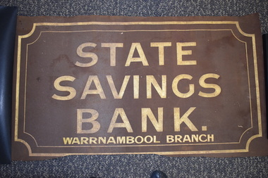 Warrnambool and District Historical Society Inc.
Sign - Artefact, State Savings Bank Trustees, Warrnambool, State Saving Bank sign, Early to mid 20th century
This sign was probably attached to a building or placed in a window and was most likely to have been at the Timor Street, Warrnambool State Savings Bank building. The State Savings Bank had its origins in the Port Phillip Savings Bank established in Melbourne in 1841 and in 1853 it became known as the Commissioners’ Savings Banks in the Colony of Victoria. A Warrnambool Savings Bank branch was established in 1859 in temporary premises and in 1860 it moved to a new building in Liebig Street. In 1884 a new sandstone building was erected in Timor Street and the bank operated from there until 1957. In 1912 the Commissioners’ Savings Banks in Victoria became the State Savings Bank. From 1957 to 1990 the Warrnambool State Savings Bank (called the State Bank of Victoria, Warrnambool Branch after 1980) had premises in Liebig Street. In 1990 the State Bank was subsumed into the Commonwealth Bank of Australia.The Warrnambool State Savings Bank was a leading banking establishment in Warrnambool for 130 years and this sign is an important memento of that institution. This is a rectangular piece of fine brown metal mesh with an ornamental gold trim around the edges and gold lettering. The edges are somewhat ragged and bent and the mesh is a little stained. ‘State Savings Bank Warrnambool Branch’state savings bank, warrnambool, history of warrnambool -
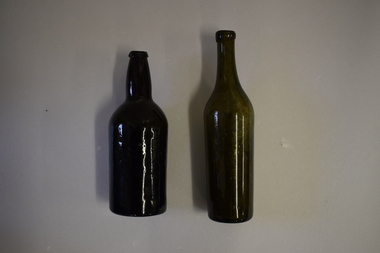 Warrnambool and District Historical Society Inc.
Bottles (2), Bottle, c. 1900
These two bottles were found by workmen building a new retaining wall on the north side of the Les O’Callaghan History House building in Gilles Street Warrnambool. The wall replaced one damaged beyond repair following a car accident in 2019. The building was erected in 1889 as the caretaker’s cottage in the Warrnambool Sea Baths complex (for most of its existence it had two swimming pools, a hot sea water baths building and a caretaker’s cottage). The water in the baths were pumped up from the ocean and, for the hot baths, heated on site. These baths were the municipal baths until the mid 1950s. The bottles may have originated from the one of the families residing in the cottage or from passers-by in the adjoining Merri Street or from patrons of the baths. They appear to be over 100 years old but there is no way the ownership of the bottles can be established.These bottles are of interest as archeological finds after repair works to the Les O’Callaghan History House. .1 A dark green (or black?) glass bottle with a hollowed out concave base, no stopper and a slightly chipped rim on the top. The bottle is stained inside. .2 A green glass bottle with a hollowed out concave base, a moulded top with no stopper and an elongated neck. The bottle is stained inside. warrnambool & district historical society, heritageworks warrnambool, les o’callaghan history house, warrnambool, history of warrnambool -
 Eltham District Historical Society Inc
Photograph - Digital Photograph, Alan King, Original Kangaroo Ground Primary School No. 2105 building, Eltham-Yarra Glen Road, Kangaroo Ground, 28 December 2007
Kangaroo Ground's first school began in 1851 with 22 pupils from the district's ten families. It was a single room school located further south on the site, which also served as a Presbyterian church. The first teacher was Andrew Ross. The school building was used as a Post Office between 1854 and 1858 and during 1857 also served as a Court of Petty Sessions. With a growing farming community, a new building was warranted and the original Sate School No. 352 was closed and a new building, State School No. 2105 was oipened October 1, 1878. A residence for Head Teacher Henry Wallace School was erected in 1879 attached to the left of the school building. That residence is now home to the Andrew Ross Museum, which opened in 1993. Covered under Heritage Overlay, Nillumbik Planning Scheme. Published: Nillumbik Now and Then / Marguerite Marshall 2008; photographs Alan King with Marguerite Marshall.; p35This collection of almost 130 photos about places and people within the Shire of Nillumbik, an urban and rural municipality in Melbourne's north, contributes to an understanding of the history of the Shire. Published in 2008 immediately prior to the Black Saturday bushfires of February 7, 2009, it documents sites that were impacted, and in some cases destroyed by the fires. It includes photographs taken especially for the publication, creating a unique time capsule representing the Shire in the early 21st century. It remains the most recent comprehenesive publication devoted to the Shire's history connecting local residents to the past. nillumbik now and then (marshall-king) collection, kangaroo ground, eltham-yarra glen road, kangaroo ground primary school no. 2105, kangaroo ground state school, state school no. 2105 -
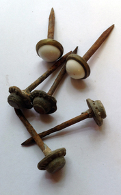 Warrnambool and District Historical Society Inc.
Functional object - Household nails, Early 20th century
These nails have no provenance but may have been used to hang pictures or as studs for farm buildings etc. Limited significance but typical of nails previously in regular use.These are 13 large iron nails. Two of them are shorter than the others and have a top with a brass edging and a white oval shaped inset of porcelain or enamel material. Eleven of them have an iron top. ‘Coop’s Latest’nails, warrnambool history -
 Eltham District Historical Society Inc
Document - Series Listing, Fraser Faithfull et al, Series 16: Eltham Leisure Centre Extensions 1990-1991 , industrial dispute, photographic negatives, 2000
Series consists of 26 colour negatives recording activity on the building site, including a visit by police officers.shire of eltham archives, series listing -
Glen Eira Historical Society
Plan - Cambria
Sixteen pages of hand drawn plans with rough measurements of various parts of the building Cambria. Undated and unattributed.cambria, plans, glen huntly, neerim road, roseberry grove -
 Ballarat Clarendon College
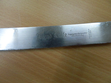
Knife
Bread knife used in Kawarau, former kindergarten, boarding house, master's home and current Administration building. Stainless steel blade, metal fixture and wooden handleInscribed on face of blade: Bread Knife / Leppington (Cutlers) Ltd / Sheffield, Eng., /Firth Brearley / Stainless Sheffield Eng. Stainlessknife, kawarau, leppington (cutlers)