Showing 3050 items
matching highway
-
 Ballarat Tramway Museum
Slide - 35mm slide/s, Peter Moses, 1/1969?
Photo of SEC Ballarat No. 39 northbound, Albert St. Sebastopol, prior to crossing the highway to the other side of the road. Tram has destination of "Lydiard St. Nth" and has a SEC "Everything's under control in my all-electric kitchen" roof advertisement. Slide dated 1970 on the back, but date lines up with Bendigo slides and type of numbering. Kodak cardboard mount slide, taken by Peter Moses assumed Jan. 1969.On the rear of the slide "Sebastopol Tram 1970" in black ink "P. Moses" along bottom left hand corner in black ink on the other side of slide.tramways, trams, albert st, sebastopol, tram 39 -
 Ballarat Tramway Museum
Slide - 35mm slide/s, Ben Parle, 8/04/1958 12:00:00 AM
Kodachrome Transparency - 35mm slide - cardboard mount, with one side with red border and words "Kodachrome Transparency / Processed by Kodak" top and bottom. Photo taken by Ben Parle 8/4/1958, date stamped onto slide. Has slide No. "13" stamped in red in top corner. Photo of Ballarat 30, outbound along Sturt St. West, opposite the City Oval. Note the lack of a centre line along the main highway. "Sturt St West" / "8-4-58"tramways, trams, sturt st west, western highway, tram 30 -
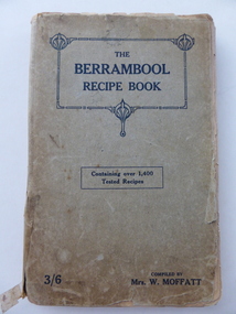 Warrnambool and District Historical Society Inc.
Book, The Berrambool recipe book, 1915
This recipe book has been compiled by Mrs W. Moffatt to raise funds for the Wickliffe Hall Improvement Fund (1915). Wickliffe is a small town in Western Victoria situated on the banks of the Hopkins River on the Glenelg Highway 100 kilometres from Warrnambool. Jessie Moffatt (nee McLellan) married William Moffatt in 1885 and died in 1938. William Moffatt leased the Berrambool Estate near Wickliffe in 1893, bought it in 1903 and the Moffatts lived there until their deaths in the 1930s. This recipe book is of interest because of its social history, telling us what recipes were popular in the early 1900s and the use made of a recipe book to raise funds for local community funds. The book is also of interest because it is an example of the voluntary work done by a woman in the Western District in the early 20th century. The book is also of interest because the names of some of those who contributed the recipes are listed and many of them have local connections. The Warrnambool names listed include Williams and McCormick. This is a soft cover book of 149 pages. The cover is grey with dark blue lettering and some ornamental patterning. The book contains over 1400 recipes and many advertisements for businesses in Victoria at the back and front of the book. There are two loose sheets of paper with recipes. The binding has come apart and has been loosely mended with adhesive tape. The cover and some of the pages are a little tattered. jessie and william moffatt of berrambool, history of warrnambool -
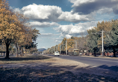 City of Ballarat Libraries
35mm Slide, Sturt Street West, Ballarat circa late 1950s
A lovely shot of the western end of Sturt Street, looking east to Mt Warrenheip. Not much traffic today! Just a tram and an early Holden, yet at the time of this photograph, this was the main highway through to Adelaide. Mrs Bon Strange and her husband Bert were well known Ballarat residents. When Mrs Strange died some years ago, her extensive slide collection was sorted through and those relevant to Ballarat were gifted to the Ballarat Library.sturt street, trams -
 Bayside Gallery - Bayside City Council Art & Heritage Collection
Map - print, Melbourne and Metropolitan Board of Works, Interim development order: Brighton, Moorabbin and Sandringham, 1959
The Melbourne and Metropolitan Board of Works (now Melbourne Water) was established in 1891. From that time, as part of their work laying water and sewerage connections, they created detailed plans of houses and other buildings in the Melbourne metropolitan area. In 1956 it acquired powers to construct and maintain highways and bridges, protect and improve the foreshores and create and maintain parks within the metropolitan region. This Interim development order comprises part of the municipalities of Brighton, Moorabbin and Sandringham and was made on 20 October 1959.brighton, moorabbin, sandringham, melbourne and metropolitan board of works, map, town planning, cartographic material, interim development order, bayside -
![Photograph, Ann [Dowling] Myers, c.1918](/media/collectors/5b29fbbc21ea6714f814b353/items/628a005d1b6dacfccb86f356/item-media/628a01041b6dacfccb86fc3e/item-fit-380x285.jpg) Melton City Libraries
Melton City LibrariesPhotograph, Ann [Dowling] Myers, c.1918
Western Highway – north side Burnbank 1 – Cottage of Henri and Ann nee Dowling Myers side of road east of Myers Gully the junction of Reserve Rd. now known as Ryans Creek. Built c 1870. it remained in the family until a demolition order was placed on it in 1969 when vacated by Martha wife of Frederick 4th son of Ann and Henry. Her new house was built in McKenzie St on the south side near the corner of Smith St. Portrait photo of Annlocal identities, pioneer families -
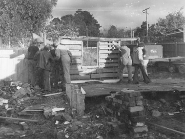 Ringwood and District Historical Society
Photograph, Dismantling Ringwood miners cottage in 1975
Typed below photograph, "Ringwood miners cottage 1873 - formerly No. 367 Maroondah Highway opposite Civic Centre. Pictured during dismantling May 1975 showing original hand split internal paling walls and flooring nailed to saplings laid directly on the ground". -
 Ringwood and District Historical Society
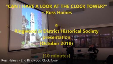
Mixed media - Video, RDHS Meeting Presentation - "2nd Ringwood Clocktower" - Russ Haines
Digitised video (932MB). Duration: 10 minutes. Recorded October, 2018. (Video is available for viewing at Ringwood & District Historical Society Archives by appointment)Ringwood and District Historical Society President Russ Haines presents this up close and personal look at, in and around Ringwood’s replica Memorial Clocktower some years after it’s re-location along Maroondah Highway from Warrandyte Road to Wantirna Road corner. -
 Orbost & District Historical Society
book, Broadbent's Melbourne - Sydney Guide Book, 1936
Broadbent's Official Road Guides Company took over George R. Broadbent's business in 1935. In 1963, it changed its name to Broadbent's Road Maps Pty. Ltd. George Robert Broadbent (1863-1947), cyclist and map publisher, was born on 3 November 1863 at Ashby near Geelong, Victoria. At various times Broadbent held most Victorian and Australian road cycling records. Broadbent became an active vice-president of the Good Roads Association of Victoria in November 1912 and was consulted regularly during the preparation of the country roads bill. That year he took over the Argus motoring column, wrote tirelessly on road improvements and maintenance, and became manager of the Automobile Club's new touring department in 1914.A 160 pp road guide book titled Broadbent's Official Road Guide Melbourne - Sydney. The front cover has a yellow background with a map of the coastline from Sydney to Melbourne, the Prince's Highway route marked. This is inset in a drawing of a car driving along the coastal road.The book contains speedometer readings, route maps, advertisements and photos of points of interest. In the top right is the logo of the Royal Automobile Club of Victoria and at the bottom right is the price 1/-.traavel road-guides broadbent-george car-touring -
 Bendigo Historical Society Inc.
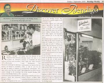
Newspaper - JENNY FOLEY COLLECTION: DISCOVER BENDIGO
Bendigo Weekly from Friday, September 1, 2000. Article by James Lerk '' Discover Bendigo from small beginnings''. One business which had its beginnings in the Bendigo Arcade, is still thriving thirty eighty years later. This article focuses mainly on the business started in the Arcade by Max Richardson on October 29, 1962. After the fire of 1974 Max moved his business on the Midland Highway at White Hills. The clip is in a plastic folder.newspaper, bendigo, bendigo weekly -
 Ballarat Tramway Museum
Slide - 35mm slide/s, Ben Parle, 8/04/1958 12:00:00 AM
Kodachrome Transparency - 35mm slide - cardboard mount, with one side with red border and words "Kodachrome Transparency / Processed by Kodak" top and bottom. Photo taken by Ben Parle 8/4/1958, date stamped onto slide. Has slide No. "14" stamped in red in top corner. Photo of Ballarat 30 (assumed on basis of Reg. Item 2885), outbound along Sturt St. West. Note the lack of a centre line along the main highway. "Sturt St West" / "8-4-58"tramways, trams, sturt st west, western highway, tram 30 -
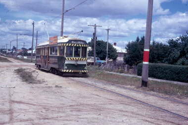
 Ballarat Tramway Museum
Photograph - Digital image Set of 3, Peter Bruce, 1970s
Yields information about the highway crossing Albert St Sebastopol from both sides.Digital image, black and white, set of three images of No. 41 crossing Albert St Sebastopol. .1 - No. 41 southbound, before crossing Albert St. .2 - ditto, after crossing Albert St .3 - No. 41 on return, north bound. Note the pole with directions for Mt Clean, Sebastopol Gun Club. Photo taken by Peter Bruce 1970's and 1971, prior to the closure of the Ballarat tramway system. Peter's Title of image: "No. 41 at the Highway"trams, tramways, albert st, sebastopol, tram 41 -
 City of Kingston
Photograph - Colour, 31 January 1993
Patterson Lakes is a suburb in the City of Kingston that is built one kilometre upstream of the mouth of the Patterson River. The area is bordered by the Patterson River and Eel Race Drain which enters the Kananook Creek. The suburb consists predominantly of newer housing developments and the tidal canal system of the development joins Port Phillip Bay. Patterson Lakes and the Kananook Creek were previously part of the extensive Carrum Carrum Swamp. The area was once a source of fish and eels for the Mayone-Bulluk clan of the Bunurong people. Over time the area was drained and in 1973 investigations commenced into the development of a unique residential area that would be built adjacent to canals and waterways. It was originally proposed to be known as "Gladesville". The development would give the suburb's homeowners access to Port Phillip Bay "from their back door". Circa 1974, the area was rezoned from rural to residential and named Patterson Lakes. Development has been continuous since the 1970s with construction of residential housing, schools, shopping centres, marinas, a hotel and library.Laminated colour aerial photograph of the Carrum and Patterson Lakes region within City of Kingston. This 1993 image includes Patterson River Secondary College, Roy Dore Reserve, Kananook Creek and Nepean Highway. The railway line can be seen as it veers inland from Eel Race Road, Seaford. The section of Ocean Reef Drive and Palm Beach Drive in Patterson Lakes appears to be a recent development with many spare blocks and new houses under construction.Black typed lettering on white adhesive label: 31.1.93 Black typed lettering on white adhesive label: 27E/7140 31/1/93 12.55 pm Black typed lettering on white label: 7140 Yellow round adhesive label located on left sidepatterson lakes, seaford, kananook creek, carrum carrum swamp, canals and waterways -
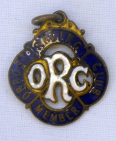 Orbost & District Historical Society
badge, 1890's
This is a member's badge for the Orbost Racing Club and belonged to Mat Lynch. Secretary was Mr W. A. Malcolm. Some of the earliest horse races were held on a course in a paddock belonging to Mr James Cowell at Jarrahmond. For a long time horse races were part of the Marlo Picnic Races. Bellagoogan on Majors Creek near Orbost was the site of the first race course. Mat Lynch was a prominent local identity and generously donated a block of land situated on the Princes Highway, for the Brodribb Hall.Horse racing played a vital role in the history of Orbost. This item is connected to that role.A small metal badge which is a diamond shape with rounded corners. It has a small metal loop at the top. In gold print is "Member Orbost Racing Club" on a dark blue enamel around the edge. In the centre is "ORC" in white enamel.On back - 28 - LYNCH - almost indecipherable.orbost-racing-club lynch-mat recreation horse-racing -
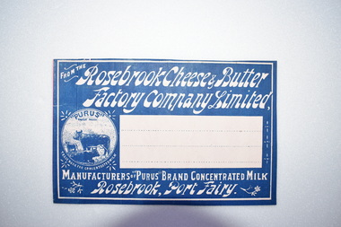 Warrnambool and District Historical Society Inc.
Label, Rosebrook Cheese and Butter Factory, Early 20th century
The Rosebrook Cheese and Butter Factory was opened in November 1888 by Messrs Lydiard &T F Rutledge & was a cooperative factory managed by Mr. Goldie. It operated out of the former Rosebrook Flour Mill which was built on the banks of the Moyne River near the Rosebrook bridge in the late 1840s. In 1896 the factory commenced the production of the condensation of milk. The company closed in 1911. The building and machinery were sold in 1917. Rosebrook is situated about 20 kilometres from Warrnambool on the Princes Highway. This label is of some local significance as the Rosebrook Cheese and Butter factory operated for 30 years Rectangular dark blue and white label featuring text and a trade mark. The latter is circular with three cows pictured. There are decorations of flowers and leaves. The central area of the label is white with three lines. The label is adhered to a piece of pink card.FROM THE Rosebrook Cheese & Butter Factory Company Limited, MANUFACTURERS OF "PURUS BRAND CONCENTRATED MILK Rosebrook, Port Fairy. "PURUS" TRADE MARK FOR CONCENTRATED MILKrosebrook, cheese and butter, concentrated milk, lydiard, rosebrook butter factory -
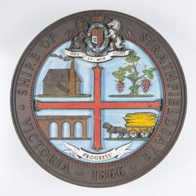 City of Greater Bendigo - Civic Collection
Sign - Shire of Strathfieldsaye Coat of Arms
The district of Strathfieldsaye was proclaimed in 1861 and named a Shire on the 17th September in 1866. It remained a shire until amalgamation in 1994 when it became part of the City of Greater Bendigo. The shire was located 8 km to the south- east of Bendigo and covered an area of 601 square kilometres and extended from the Calder Highway to the Coliban and Campaspe Rivers. The shire's administration centre was in Strathfieldsaye until 1972 when new offices were opened in Kennington. This coat of arms was commissioned for the front of the shire hall building.Brass painted coat of arms or emblem within a circle of the Shire of Strathfieldsaye. Outer rim contains text: SHIRE OF STRATHFIELDSAYE VICTORIA 1866 with the shield of the monarch of the United Kingdom centre top. The shield is divided into four parts with images reflecting the leading industries of the time; wine growing, mining, farming and tanning. The motto PROGRESS is depicted lower centre of shield. SHIRE OF STRATHFIELDSAYE / VICTORIA / 1866 / PROGRESSshire of strathfieldsaye, city of greater bendigo amalgamation, city of greater bendigo signs -
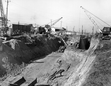 City of Kingston
Photograph - Black and white, c. 1958
Moorabbin station sits on the Frankston line which first opened in 1882 when the line was extended from Mordialloc. Moorabbin station opened in 1881 and was originally called South Brighton station. It was renamed Moorabbin station in 1907. In 1958 the station was relocated below street level which coincided with other construction works on Nepean Highway and South Road. This image is part of a larger collection of images from the Public Transport Corporation displaying train stations and streetscapes in what is now the City of Kingston.Black and white photograph showing excavations for Moorabbin station to be moved below street level. Stamped in blue ink on reverse: COPYRIGHT / Public Transport Corporation / For re-ordering photographs / Please quote negative No M6004 / Enquiries C/- PTC Photographic Unit / Telephone switchboard 619 111moorabbin, railway station, construction works, suburbs, nepean highway -
 Warrnambool and District Historical Society Inc.
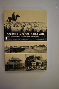
Book, StarPrinting Service Pty ltd, Soldiering On – Caramut and the Soldier Settler Movement, 2018
This book records the history of the post World War Two soldier settlement farms in the Caramut area. Number two in a series of books on Soldier Settlements in Western Victoria.This is a soft cover book of 315 pages. It has a buff-coloured cover with black and white photographs and white printing on the front cover and black printing on the spine. The book includes printed material, black and white photographs, maps and plans. non-fiction This book records the history of the post World War Two soldier settlement farms in the Caramut area. Number two in a series of books on Soldier Settlements in Western Victoria.james affleck, peterborough, soldier settlement, caramut, history of warrnambool, soldier settlement, caramut -
 City of Moorabbin Historical Society (Operating the Box Cottage Museum)
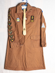
Clothing,Uniform Brownie Guide,yellow tie,brass badge, c1960
Lieutenant General Robert Stephenson Smyth Baden-Powell, 1st Baron Baden-Powell, OM, GCMG, GCVO, KCB, KStJ, DL, was a British Army officer, writer, founder and first Chief Scout of the world-wide Scout Movement, and founder, with his sister Agnes, of the world-wide Girl Guide / Girl Scout Movement Kingston H Pack was a group located in South East Melbourne The Scout and Guide movement was a very popular post war youth movement that taught children self confidence, reliability, outdoor survival skills, with companionship, adventure, fun and discipline.A brown cotton Brownie Guide Uniform with achievement badges sewn on sleeves, shoulder and chest and a yellow tie with buttons and a brass clover badge On Right Sleeve ; 8 Achievement Badges, Right Chest ; Highway, Vent Pack On Left Shoulder ; Kingston H Pack Sth Metro Region , Patch with Star 2 ; Left Sleeve: Venture Triangle , Pack Holiday; Left Chest: Brownie , 2 yellow stripes girl guides, brownies, general baden-powell, baden -powell agnes, kingston h pack brownie guides, scouting, clothing, underwear, petticoats, knitting, dressmaking, theatrical props, craftwork, sequins, beading, early settlers, moorabbin shire, mechanics institute cheltenham, ormond choral society, postworld war 11 settlers, housing estates moorabbin 1950, bentleigh, ormond, moorabbin, cheltenham, drama societies, musical society cheltenham, clark judy, reed gladys, reed george -
 Ringwood and District Historical Society
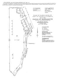
Document - Subdivision Plan, LP113220 Part of Crown Allotments 35 & 39B, Parish of Warrandyte, County of Mornington, Vol 6421 Fol 183 & 184 - 1965
LANDATA Land Victoria 2-sheet plan printout dated 2009Sheet 1 includes Kalinda Road, Ringwood. Additional markings include LP113117. Sheet 2 includes Kalinda Road and Maroondah Highway, Ringwood. Additional markings include LP86253. Both sheets include location of Drainage and Sewerage Reserve along Mullum Mullum Creek. -
 Ringwood and District Historical Society
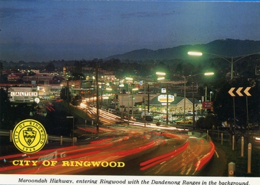
Postcards, Colorscans (Publishing) Pty Ltd, Various postcards of Ringwood in the 1970s, c. 1968
Postcards - pack of 6: 'Ringwood Victoria - tear off postcard folder - 6 views' (two identical folders); 1. Maroondah Highway, entering Ringwood with the Dandenong Ranges in the background (3303_001.jpg); 2. Aerial View of the City of Ringwood (3303_002.jpg); 3. Eastland Regional Shopping Centre at dusk (3303_003.jpg); 4. The Ringwood Memorial Clock Tower (3303_004.jpg); 5. The Civic Centre (3303_005.jpg); 6. The Ringwood Lake (3303_006.jpg) -
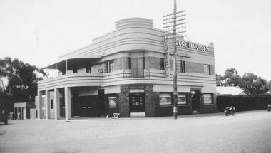 Ringwood and District Historical Society
Photograph, Coach and Horses Hotel, Ringwood circa 1940
Black and white photograph of Coach and Horses Hotel in Maroondah Highway, west of New Street, now adjacent to Eastlink Freeway, on northern side. There are two duplicate photos. Certainly the photo was taken post-1940 as the previous Coach & Horses Hotel, on the south side, burnt down in 1940. The telephone pole indicates that era, with limited lines. The style of the building was Art Deco that generally existed in the 1920s-1930s but did continued in Australia in the 1940s. The building has the appearance of being newly-built. Was H4, in the old cataloguing system. -
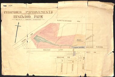 Ringwood and District Historical Society
Map, Proposed Improvements to Ringwood Park (Ringwood Lake) dated 14 January 1927
Proposed Improvements to Ringwood Park (Ringwood Lake) dated 14 January 1927, signed Cr McCaskill. Main Road is Whitehorse Road (Maroondah Highway), and Mt Dandenong Road is incorrectly labelled Whitehorse Road. The map shows Rosedale Crescent and Railway Parade, both of which exist in 2024. On the bottom of the map, south of the railway line, showing proposed streets - Graham Road, Anderson Street and Adams Street - in preparation for the sale of the Theo Anderson property. That area is now Bedford Park. -
Bendigo Historical Society Inc.
Map - CAMPBELL COLLECTION: BENDIGO AND DISTRICT MAPS
Map. Bendigo Whipstick Forest Park, 1:75,000, reserved forest and crown land, highway main road access forest tracks. New Moon Mine, Elliot Dam, Nuggety Dam, Rogers Tree, Old Tom Mine, Blow Holes, Skylark Dam, Monument Rock, Hartland Eucalyptus Still and Dam, Hartland Eucalyptus Farm, Millwood Dam, Sandner Eucalyptus Still Site, Various unmarked dams. (number 391 in map cupboard 1)map, bendigo, country lands -
 Whitehorse Historical Society Inc.
Photograph, Mitcham Scene C.1910, C.1910
Original Photo courtesy of Melbourne WaterFramed Black and White Photo of Whitehorse Road, Mitcham, in approx 1910 showing St Johns Roman Catholic Church - School (Church 1872-1952 and School 1872 - 1931) in centre, the School Teachers Cottage at left (1902 - 1935)and Mitcham's first Police Station (1888 - 1950) on the right. In the background in the extreme can be scene the original Mitcham Railway Station (1882)In the foreground is what was known as 'The Great 3 Chain Road' now Whitehorse Road (Maroondah Highway).st john's catholic church mitcham, whitehorse road, mitcham, school teacher's cottage, mitcham police station, mitcham railway station, great three chain road, melbourne water -
 Ballarat Tramway Museum
Slide - 35mm slide/s - set of 4, Dave Simpson, late 1960's early 1970's
Yields information about Drummond St south and its use by trams.Set of four 35mm slides - AGFA dark blue / white plastic mounts of trams in Drummond St south. .1 - No. 40 with destination of Lydiard St North near the intersection with Eyre St. .2 - at the intersection. .3 - No. 40, southbound with the destination of Sebastopol, near La Trobe St. .4 - No. 39, northbound with the destination of Lydiard St North at the intersection with Darling St and now the Midland Highway. Has a Shell petrol station in the background. Note the Give Way sign.tramways, trams, drummond st sth, darling st, tram 40, tram 39 -
 Kew Historical Society Inc
Award, Mental Hospitals Ladies Golf Competition, Commemorative Shield, 1930-1932
An Article in The Herald (18 Feb 1931) records that: "FAIRVIEW OFFICIALS - AT the annual meeting of the Associates of the Fairview Golf Club the following office bearers were elected: President, Miss A, Simcocks; secretary, Miss B. Williamson; captain, Miss A. Shiells; committee, Misses Tresise, Walters, Brown and McLachlan. The captain reported that the shield presented by Mr and Mrs Bourne for competition among the clubs associated with the metropolitan mental hospitals had been won by Fairview associates, who will hold it for one year."The trophy has historical significance as an item associated with the Melbourne Mental Hospital in the 1930s and also of social significance in that it relates to recreational pursuits undertaken by staff of the Hospital.Wood and silver plate shield won by the ladies team of Fairview Golf Club in the years 1930, 1931 and 1932. The Golf Club was established in 1928, and was owned and managed as part of the Kew Mental Hospital. The 9-hole golf course was located next to the Chandler Highway and is currently the site of the headquarters of Guide Dogs Victoria. The trophy formed part of the personal collection of Dr Fred Stamp, which was donated to the Kew Historical Society following his death in 2018 by his family.Inscriptions on silver plate plaques - Top "Mental Hospitals", Bottom: "Ladies Golf Competition"; Bottom left: "Fairview Golf Club 1930", "Fairview Golf Club 1931" and Fairview Golf Club 1932".fairview golf club, golf - womens competitions - victoria, trophies - golf -
City of Kingston
Photograph - Black and white, 5 January 1984
Moorabbin, Cheltenham and Highett are suburbs in the City of Kingston with a diverse mix of development and zoning. The market gardens, farms and paddocks have gradually been sub-divided into housing and industrial estates and associated infrastructure such as schools and shopping facilities. The area includes many parks, reserves and golf courses.This aerial image covers a diverse section of the City of Kingston, taking in the suburbs of Cheltenham, Moorabbin, Beaumaris and Highett. By 1984, the market gardens of the district have been replaced by housing and factories. The Gas and Fuel state-of-the-art Scientific Services Department is visible on Nepean Highway Highett. The CSIRO Highett site can also be seen. Both sites have now been demolished and have undergone remediation. The Southland site is visible and yet to be redeveloped by Westfield. This image portrays the diversity of development in the City of Kingston with a mixture of green spaces, housing and commercial and industrial features.Aerial photograph of Cheltenham, Beaumaris, Moorabbin and Highett within the City of Kingston. The area depicted in the 1984 aerial view includes Eden Street and Edward Street, Cheltenham (top left), Weatherall Road and Reserve Road, Cheltenham/Beaumaris (top right), Turner Road and Chesterville Road, Moorabbin (bottom left), Nepean Highway (left section), Graham Road and Middleton Street, Highett (bottom right). A large section of this image includes Cheltenham Park and Victoria Golf Club.White text: 3831-219 Lens information [indecipherable] RINGWOOD M/S 7922-3 RUN 15 Clockface image 5,300' ASL VIC DLS© 5-1-84cheltenham, highett, industrialisation, urbanisation, moorabbin, beaumaris -
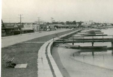 Lakes Entrance Historical Society
Postcard - Lakes Entrance, Bulmer H D, 1940c
From a wallet of minitiature postcards published by Bulmer for sale to tourists. Also enlarged black and white copy 18.5 x 25 cm,Black and white mini postcard of Esplanade, showing timber groynes for sand control at edge of lake at walking path of concrete slabs. Across the highway from left to right is Kia-Ora House, Heyfield House, Coate Bros Garage, Robin Hood Inn, Vizes Cafe, Vic Carstairs, Miss Brown's (subagent for Statebank), Methodist Church, Bellevue Guest House, Police Station, Maranui Guest House, Glenara Guest House. Lakes Entrance Victoriatownship, waterfront, accommodation -
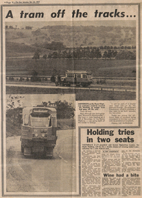 Melbourne Tram Museum
Newspaper, The Sun, “A tram off the tracks”, 22/10/1977 12:00:00 AM
“A tram off the tracks” The Sun, Saturday, Oct 22, 1977 Photos and text Tram # 86 Photos of tram # 86 being transported on semi-trailer on Hume Highway at Beveridge on its way to Orange, NSW. Part of display by Bathurst-Orange Development Corporation, planning to build a new town between the two cities. Trams among the different types of transport being considered to link the proposed town to its neighbours. Tram displays “Brunswick-Moreland Rd” and route number 954.trams, tramways, displays, trucks, z class, transporting trams, tram 86