Showing 10954 items matching "land "
-
 Ballarat Heritage Services
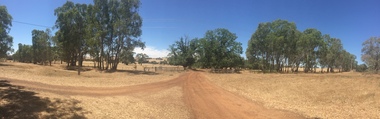
Photograph, Clare Gervasoni, Entrance to Merino Downs, Henty, 2015, 22/12/2015
Merino Downs was the property of early squatters the Henty brothers. Pentonvillian Exile George Ind worked for the Henty's at Merino Downs after his arrival at Portland in 1845. The Henty daughters were witnesses to his marriage. Colour panoramic photograph of land around Merino Downs, Henty, Victoriahenty, merino downs, henty brothers, george ind, henty daughters, panorama -
 Bendigo Historical Society Inc.
Document - Victoria the Land Act 1890 and the Wattle Act 1891, 1888-1892
Victoria the Land Act 1890 and the Wattle Act 1891 283 pages. Inside the front cover which has been removed the page has been filled with an indecipherable hand written memo..history, bendigo, mining, victorian land act -
 Kew Historical Society Inc
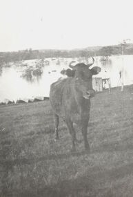
Photograph, Cattle in North Kew floods, 1934
The year 1934 witnessed the greatest flooding of the Yarra River since settlement. This work forms part of the collection assembled by the historian Dorothy Rogers, that was donated to the Kew Historical Society by her son John Rogers in 2015. The manuscripts, photographs, maps, and documents were sourced by her from both family and local collections or produced as references for her print publications. Many were directly used by Rogers in writing ‘Lovely Old Homes of Kew’ (1961) and 'A History of Kew' (1973), or the numerous articles on local history that she produced for suburban newspapers. Most of the photographs in the collection include detailed annotations in her hand. The Rogers Collection provides a comprehensive insight into the working habits of a historian in the 1960s and 1970s. Together it forms the largest privately-donated collection within the archives of the Kew Historical Society.Photograph of floodwaters encroaching on farm land in North Kew in the flood of 1934.Nth. Kew. 1934 Floodsfloods (melbourne) 1934, dorothy rogers -
 Canterbury History Group
Document - Land Title, 162 Canterbury Road Canterbury, 2018
History of the ownership of the land corner of Canterbury Road & Keats Street Canterburysoldiers' memorial hall, keats street, canterbury road, logan> margaret, logan> michael, malone> william, mcgee> peter rev., balloch> john, balloch> robert johnston, hay> james, hoskin> william thomas, salvation army, gates> william fleming, coghill> george -
Bendigo Historical Society Inc.
Document - COPIES OF CERTIFICATES OF TITLES FOR LAND OWNED BY BENDIGO POTTERY
BHS CollectionCopies of Certificate of titles for land owned by Bendigo Pottery 1880 - 1910.bendigo, land sales -
 Ringwood and District Historical Society
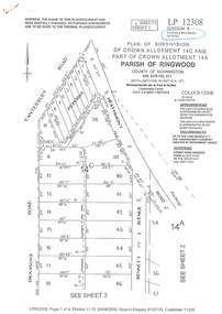
Document - Subdivision Plan, LP12308 Crown Allotment 14C and Part of Crown Allotment 14A Parish of Ringwood, County of Mornington Vol 5378 Fol 511 - Circa 1927
LANDATA Land Victoria 4-sheet plan printout dated 2009.Sheet 1 includes Canterbury Road, Heathmont Road, Dickasons Road and Bennett Avenue, Heathmont. Additional markings include PC353066. Sheet 2 includes Heathmont Road, Bennett Avenue and Orchid Street, Heathmont. Additional markings include PS326369 and SP24567. Sheet 3 includes Dickasons Road and Bennett Avenue, Heathmont. Additional markings include LP46776, SP28005 and PS335189. Sheet 4 includes Dickasons Road, Bennett Avenue and Orchid Street, Heathmont. Additional markings include SP25998, SP31080, SP31780, SP25968, SP25969 and LP46475. -
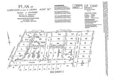 Ringwood and District Historical Society
Document - Subdivision Plan, LP11645 Part of Crown Allotment 26A, Parish of Ringwood, County of Mornington Vol 5164 Fol 1032616 - 1926
LANDATA Land Victoria 2-sheet plan printout dated 2009Sheet 1 includes Mount Dandenong Road, Valda Avenue and Velma Grove, Ringwood East. Additional markings include SP35514, SP22189, SP34206, SP35514, SP26794, PS319109, PS319010 and PS304868. Sheet 2 includes Mount Dandenong Road, Valda Avenue, Mirabel Avenue and Velma Grove, Ringwood East. Additional markings include SP26430, SP25320, PS341575, PS319110, PS319010, LP48415, SP22732, SP25844, PS304936 and PS304937. -
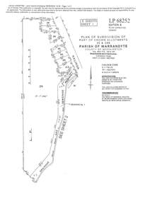 Ringwood and District Historical Society
Document - Subdivision Plan, LP113220 Part of Crown Allotments 35 & 39B, Parish of Warrandyte, County of Mornington, Vol 6421 Fol 183 & 184 - 1965
LANDATA Land Victoria 2-sheet plan printout dated 2009Sheet 1 includes Kalinda Road, Ringwood. Additional markings include LP113117. Sheet 2 includes Kalinda Road and Maroondah Highway, Ringwood. Additional markings include LP86253. Both sheets include location of Drainage and Sewerage Reserve along Mullum Mullum Creek. -
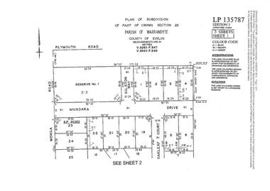 Ringwood and District Historical Society
Document - Subdivision Plan, LP135787 Part of Crown Section 23, Parish of Warrandyte, County of Evelyn, Vol 9293 Fol 947 and Vol 9503 Fol 640 - 1984
LANDATA Land Victoria 3-sheet plan printout dated 2007Sheet 1 includes Wonga Road, Mundara Drive, Gilston Way and Oakleaf Court, Ringwood. Additional markings include SP25252. Sheet 2 includes Wonga Road and Oakleaf Court, Ringwood. Sheet 3 includes Wonga Road, Wyndarra Court and Gem Close, Ringwood. -
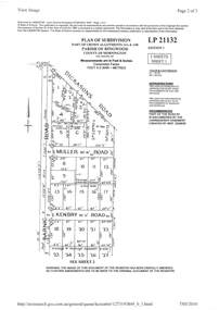 Ringwood and District Historical Society
Document - Subdivision Plan, LP21132 Part of Crown Allotment 14A & 14B, Parish of Ringwood, County of Mornington Vol 4929 Fol 657 - (Undated, circa 1920s/30)
LANDATA Land Victoria 2-sheet plan printout dated 2010.Sheet 1 includes Dickasons Road, Barnic Road, Muller Road and Kenbry Road, Heathmont. Sheet 2 includes Barnic Road and Possum Lane, Heathmont. Additional markings include LP83779. -
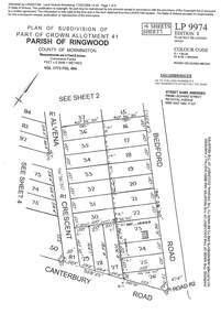 Ringwood and District Historical Society
Document - Subdivision Plan, LP9974 Part of Crown Allotment 41, Parish of Ringwood, County of Mornington Vol 1773 Fol 464 - 1924
LANDATA Land Victoria 4-sheet plan printout dated 2009Sheet 1 includes Alvena Crescent, Bedford Road and Canterbury Road, Heathmont. Additional markings include RP16869. Sheet 2 includes Alvena Crescent and Bedford Road, Heathmont. Additional markings include PS318390 and CP161633. Sheet 3 includes Bedford Road, Alvena Crescent and Royal Avenue, Heathmont. Additional markings include RP454. Street name amended from Leonard Street to Royal Avenue Vide Gaz 1962 P.427. Sheet 4 includes Alvena Crescent, Royal Avenue, Coleman Street and Canterbury Road, Heathmont. Additional markings include SP27861, PS305057, RP10566, SP34722 and LP116573. -
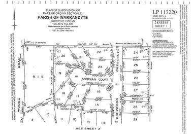 Ringwood and District Historical Society
Document - Subdivision Plan, LP113220 Part of Crown Section 23, Parish of Warrandyte, County of Evelyn Vol 8970 Fol 687 - 1975
LANDATA Land Victoria 2-sheet plan printout dated 2009Sheet 1 includes Wonga Road, Holyrood Crescent and Georgian Court, Ringwood. Sheet 2 includes Wonga Road, Holyrood Crescent and Stonington Place, Ringwood. -
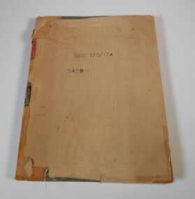 Bendigo Historical Society Inc.
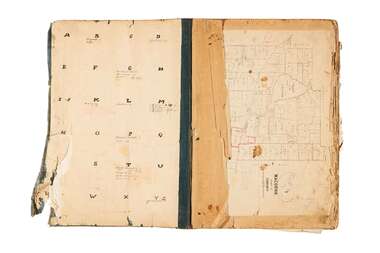
Administrative record - Application Register
The book original cover is dark green that has been wrapped in brown canvas to protect it. It has a leather spine with red and black labels. The pages in the volume are divided in columns: 1) Number of application, 2) Date of registry, 3) Date of application, 4) Surname, 5) Christian name and address, 6) Parish, 7) Allotment, 8) Section, 9) rea, 10) Local land board schedule, 11) Decision, 12) Special condition, 13) License, 14) References and remarks. The dates of the applications are from 30th August, 1874 to 26th April, 1876.On the front canvas cover: sec 173/174 3420. On the spine red label with gold letters: Application register. A black label with gold letters: all other sections land act 1901 (some of the letters are damaged)application register, land act 1901, 1874 to 1876 -
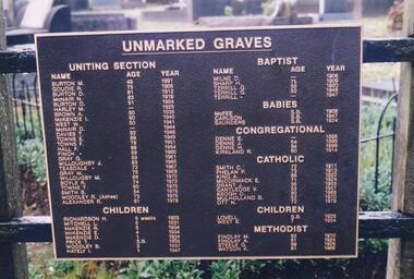 Phillip Island and District Historical Society Inc.
Photograph Album, Kodak, Phillip Island Cemetery, c 1990
The Album was compiled by Nancy McHaffie late 1990's, with the assistance of Edith Jeffery's, with her book "Garden of Memories" and extensive knowledge of Phillip Island. The Cemetery lies back from the road and is surrounded by Manna Gums, rare Peppermint Gums, Blackwoods and other native trees. In all 25 acres of land were set aside as Crown Land in the land settlement of 1868. There are 6.2 acres of wetlands near the cemetery entrance.2 Photographs: 466-08 Notice of the Unmarked Graves. Although the land for the cemetery was granted in 1870, a survey was not made until 1903 hence the existence of unmarked graves. 466-09 A disastrous fire swept through the cemetery in 1943, destroying many structures around the graves - hence the rule "no wooden structures". the Hitching Posts were used for tying up hrses during a funeral service. They were erected in 1912 and now only two remain.phillip island cemetery, nancy mchaffie, edith jeffrey -
 Kew Historical Society Inc
Photograph - View of the Yarra River from 8 Kellett Grove, North Kew, 1948
North Kew, now divided between Kew and Kew East, bordered the Yarra River. As such, it was a region subject to flooding in the Yarra Valley. Development beyond this point (ie Kellett Grove) was limited by the City of Kew's planning regulations. Prior to urban development, the area since European settlement and the first land sales in the district in the 1840s, had been used for dairy farming. The view from the rear of 8 Kellett Grove predates the construction of the Eastern Freeway so provides a rare view of the area before it was built.Small sepia snapshot taken from the back yard of a house at 8 Kellett Grove, in what was then known as North Kew. A tower of the Kew Asylum on the top left of the horizon assist the viewer to recognise that the land to the left of the river is in Kew and Studley Park.Verso: NORTH KEW 1948 / Stamped 51019yarra river -- north kew, kellett grove -- north kew -
 Federation University Historical Collection
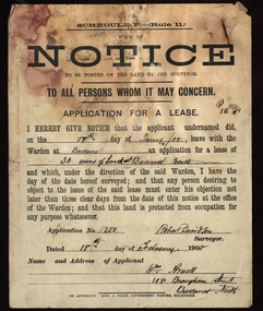
Document, Notice, 18/02/1908
Form of Notice regarding an application for a lease to be posted on the land by the surveyor. The land in question is 30 acres at Ballarat North and the applicant was William Arnell of 108 Brougham Street, Ballarat North, and the surveyor was Robert Davidson.land lease, robert davidson, william arnell, ballarat north -
 Bendigo Historical Society Inc.
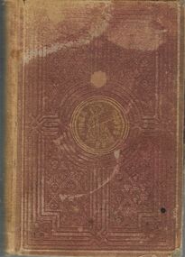
Book - THE LAND AND THE BOOK, 1870
Book, Les Gillies Collection, The Land and the Book or, Biblical Illustrations drawn from The Manners and Customs, the scenes and scenery of The Holy Land. London; T.Nelson and Sons, Paternoster Row, Edinburgh; and New York. 1870.W.M.Thomson, D.D., 30 years Missionary in Syria and Palestine.religions, christian, christian religion -
 Whitehorse Historical Society Inc.
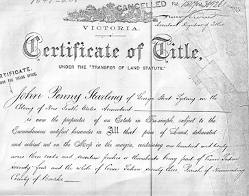
Land Title, Certificate of Title, 4/04/1884
Certificate of Title dated 4 April 1884 in the name of John Penny Starling. The land is between Whitehorse Road and 'Clarkes Road'. The land was leased to Edward Alexander and passed to Elizabeth Jane Starling in 1886.starling, john penny, alexander, edward, parish of nunawading, elizabeth jane, land sales, john penney -
 Kiewa Valley Historical Society
Photograph Farm Land, Mount Beauty Acreage before Golf Course, Circa 1950
This photograph is a "snap shot" in time circa 1950s detailing the rural environment before the effects of the Kiewa Valley Hydro Scheme altered the basic rural setting of the valley. The golfing fairway was being mapped out on previous grazing land, before the laying of a golf course, for use by the construction workers and auxiliary administration employees of the Victorian State Electricity Commission. This photograph details a dramatic period in time which saw an enormous change to the exclusively rural area of the Kiewa Valley region in the mid 1900s. This change presented both physical and mental challenges to the existing quiet rural inhabitants of the valley. The State of Victoria had to make adjustments to the changing demands imposed by population and industrial expansions. The development of cleaner energy supplies to a growing population has its downside ,which ever way the intrusion into the "natural" landscape is made.Black and white photograph detailing surveyor posts for construction of golf course. Land used, before establishment of the Mount Beauty Village, as farming/grazing cattle and viewed towards Mount Bogong and its Alpine ranges. The photo is on 200gms paper and not on photographic paper.nilmount beauty in the 1940s - 1950s, grazing in the kiewa valley, sec victoria -
 Bendigo Historical Society Inc.
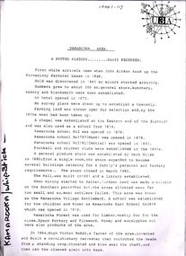
Document - STRAUCH COLLECTION: KAMAROOKA/WHIPSTICK AREA
Envelope containing information & maps on Kamarooka area, includes Kamarooka & Whipstick State Parks, Elmore, Huntly.place, land, kamarooka, kamarooka-whipstick-state parks -
 Bendigo Historical Society Inc.
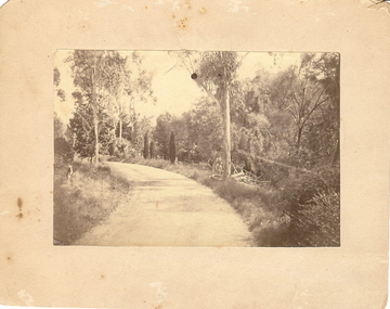
Photograph - BOTANICAL GARDENS
sepia photograph on cream board. Driveway/pathway, gravelled, eucalypt and conifer trees, uncut grass, wire fence middle distance. Pathway curving to left from front of photo. Written in blue pen on rear of photo : Botanical Gardens or early path in Fortuna. English trees planted, e.g. cypress. Holdsworth Road, adj. White Hills Cemetery Reserve. Crowned road grade. Heavy intermediate fence posts.unknownplace, land, botanical gardens, fortuna ? -
 Bendigo Historical Society Inc.
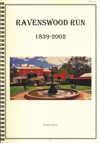
Book - RAVENSWOOD RUN
Ravenswood Run 1839-2002, the history of from its very beginnings, 64 pages with black and white & colour photographs in a spiral binder.Rita Hullplace, land, ravenswood, history-ravenswood-bendigo-pastoral -
 Bendigo Historical Society Inc.
Photograph - PALL MALL, BENDIGO, 1926 - 28
BHS CollectionPall Mall Bendigo. black and white photograph. View of Pall Mall from top of building at Charing Cross, showing Queen Victoria statue, RSL Hall, Post Office, School of Mines in distance, Shamrock Hotel at right. Envelope also in folder.Fred Smithplace, land, pall mall, bendigo -
 Bendigo Historical Society Inc.
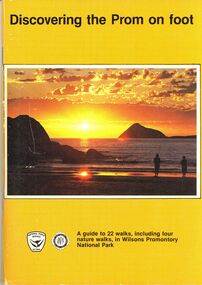
Book - STRAUCH COLLECTION: DISCOVERING THE PROM ON FOOT
BHS CollectionDiscovering the Prom on foot, a guide to 22 walks, including four nature walks, in Wilsons Promontory National Park, a joint publication of the National Parks Service, Victoria and the Victorian National Parks Association, 64 pages with black and white photograpgs, illustrations & maps.place, land, wilsons promontory, victoria-national parks- nature walks -
 Glenelg Shire Council Cultural Collection
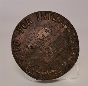
Functional object - Survey Mark
Brass mushroom shaped object. The stalk end has a split in the bottom like an old peg. The top of the marker has 50 pound penalty for interference on it. It looks as though several words have been chipped off or out from the middle of the top. Look to be ' Survey Mark'Penalty 50 for interferencesurvey, surveying tool, land, marker -
![Map, Liquidator's sale, 1896. [Woolpack Estate, Bacchus Marsh]](/media/collectors/5e461d8021ea67224c82f2a1/items/6779ee97032b72846b5995f2/item-media/6779ef33032b72846b599b30/item-fit-380x285.jpg) Bacchus Marsh & District Historical Society
Bacchus Marsh & District Historical SocietyMap, Liquidator's sale, 1896. [Woolpack Estate, Bacchus Marsh]
The Woolpack Estate was an area of land owned by various landowners in the Bacchus Marsh area since the early Colonial period of the 1840s. The area was located on the eastern side of the Bacchus Marsh township about 7 kilometers from the town. The Lerderderg River ran through part of the land and so did the Melbourne to Ballarat Road. The historic Woolpack Inn associated with James Crook was also located on this land. By 1896 150 acres of this land was under the control of liquidators for the Federal Bank of Australasia who instructed that the land be sub-divided and sold in lots by public auction. A successful sale was held on 24 June 1896. Most of the blocks of land were sold for higher than expected prices and most of the buyers were people from the town and district of Bacchus Marsh. The map includes various details about the land which is described on the map as an "important sale of rich alluvial irrigable flat land in the Bacchus Marsh Valley, and other properties". The auction was conducted by the local agents W. Anderson and Bence in conjunction with Pearce Brothers also of Bacchus Marsh.A single page paper map showing a plan of 150 acres of land from the Woolpack Estate to be sold in various lots in June 1896. Also shown on the map are lots for sale at Robinson's Farm on Coimadai Creek and allotments near Bacchus Marsh railway station, including lots on Government Road (East Maddingley Road), View Street and Government Road (Parwan Road). No scale provided. The map is pasted into a bound volume containing 76 maps or plans in total. High resolution digital image stored on BMDHS computer network. land sales bacchus marsh, bacchus marsh victoria maps, woolpack estate bacchus marsh victoria -
 City of Greater Bendigo - Civic Collection
Administrative record - Land Sales, A. J. Mullet Government Printer et al, 1927
This type of album was made by agents auctioning and selling land.Large portfolio style album with dark green / black cloth cover bound with three large metal pins. Forty eight pages with twenty seven Department of Lands and Survey maps and newspaper clippings about land sales and auction details pasted in. Index page. Maps have handwritten notes and markings throughout in pencil and pen. Covers the County's of Gunbower and Tatchera. Includes a receipt slip with hand written notes on reverse on William Wallace & Co letterhead. city of bendigo commerce -
 Bendigo Historical Society Inc.
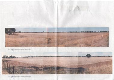
Photograph - Kangaroo Flat Gold Mine Collection: photos of Woodvale site, Daly property, pre dam construction, 1986
Photographs taken at the time of the purchase by Western Mining Corporation of the property owned by G.P. Daly of Raywood Road, Woodvale, in 1986. The intent of the purchase was to provide land for the Woodvale ponds. Land size was 16 acres, known as Allotment 13, Section 3, Parish of Nerring. Paper with two colour photographs attached, each of three photos joined to show landscape view, of the property purchased from G.P Daly by Western Mining Corporation. Photographs show rural land, grassy paddocks with tree line in background. Barb wire fence visible in foreground of bottom photo. Top photograph is titled 23. Daly property looking south-east. Bottom photograph is titled 24. Daly property looking north east. woodvale, g.p. daly, western mining corporation, purchase -
 Bendigo Historical Society Inc.
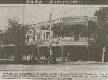
Newspaper - JENNY FOLEY COLLECTION: LAND BILL
Bendigo Advertiser ''The way we were'' from 2000. Land Bill - The main purpose of the Bendigo Land Bill was to authorise the sale of land at the corner of Mitchell and High streets for 9000 Pounds. In 1870 the site was a gold mine on which a Bendigo councillor, Dr Boyd, had erected buildings, one of these buildings was the City Club Hotel. The clip is in a folder.newspaper, bendigo advertiser, the way we were -
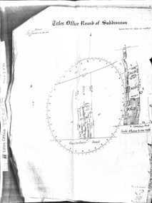 Whitehorse Historical Society Inc.
Document - Land Title, Titles Office Record of Subdivision, 25/11/1885
Photocopies of record of subdivision of David Boyle's land in Canterbury Road, Forest Hill covering the period from November 1885 to February 1898 including a scale drawing of the land and the creation of an easement for Mount Pleasant Road.boyle, david, walter, william james, joseph nash, alexander, janet kennedy, furborough, henry, canterbury road, forest hill, mount pleasant road, land subdivision