Showing 2104 items
matching structures
-
 The Beechworth Burke Museum
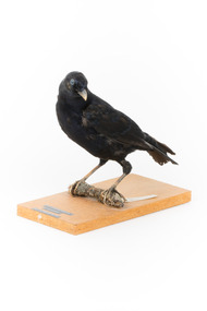
Animal specimen - Satin Bowerbird, Trustees of the Australian Museum, 1860-1880
The Satin Bowerbird is a medium-sized common bird found from Queensland to Victoria in rainforests and wet sclerophyll forest. During the summer, the diet consists mostly of fruit, with insects as a supplement. They're famous for their courtship behaviour and for decorating stick-structured nests with blue sparkling objects. With it's stunning glossy blue-black feathers, which evolve from green-brown in appearance, this Satin Bowerbird is more than seven years old, and therefore, not any younger as they are often mistaken for females, which are supposed to look like the green catbird. The eyes of this mature male are violet-blue, and the bill is pale bluish white. This specimen is part of a collection of almost 200 animal specimens that were originally acquired as skins from various institutions across Australia, including the Australian Museum in Sydney and the National Museum of Victoria (known as Museums Victoria since 1983), as well as individuals such as amateur anthropologist Reynell Eveleigh Johns between 1860-1880. These skins were then mounted by members of the Burke Museum Committee and put-on display in the formal space of the Museum’s original exhibition hall where they continue to be on display. This display of taxidermy mounts initially served to instruct visitors to the Burke Museum of the natural world around them, today it serves as an insight into the collecting habits of the 19th century.This specimen is part of a significant and rare taxidermy mount collection in the Burke Museum. This collection is scientifically and culturally important for reminding us of how science continues to shape our understanding of the modern world. They demonstrate a capacity to hold evidence of how Australia’s fauna history existed in the past and are potentially important for future environmental research. This collection continues to be on display in the Museum and has become a key part to interpreting the collecting habits of the 19th century.Satin Bowerbirds are medium-sized birds. The adult male has striking glossy blue-black plumage, a pale bluish white bill and a violet-blue iris.Swing tag: National Museum Victoria / Satin Bowerbird / Ptilonorhynchus Violaceus / B2027 / (Vieillot) / W. Shaw Collin. / Mount: PTILONORHYNCHUS / VIOLACEUS / SATIN BOWERBIRD / taxidermy mount, taxidermy, animalia, burke museum, beechworth, australian museum, skin, reynell eveleigh johns, bird -
 The Beechworth Burke Museum
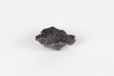
Geological specimen - Fluorite (purple)
Fluorite comes in a variety of natural colours and crystal formations and glows under ultraviolet light (the word 'fluorescence' comes from the same etymological source). In its pure form, calcium fluoride, it is a colourless combination of the elements calcium and fluorine, but gains its colour from trace elements that infiltrate or replace calcium within its crystal structure during its formation. Although fluorite crystals polish well and can achieve a high level of lustre, the mineral is very soft (4 on MOHS hardness scale) so it is unsuitable for use in rings and must be handled and stored carefully if used in other forms of jewellery. Most crystals of the mineral are too coarse for decorative purposes but have been mined under the name fluorspar for a variety of commercial and industrial purposes. These include the production of hydrofluoric acid, smelting metal alloys, producing glazes and ceramic finishes and use in medical and dental products. An existing label for this specimen indicates that its origin or collection-point was 'probably USA.' Fluorspar, the form of fluorite used commercially and industrially, was mined in significant quantities in the counties of Hardin and Pope in South-Eastern Illinois throughout the Nineteenth and Twentieth Centuries. Fluorite was made Illinois' state mineral in recognition of its contribution to the state's identity and economy. The specimens are significant as examples of surveying activity undertaken to assess and direct the development of the mineral resource industries, as well as the movement to expand human knowledge of earth sciences such as mineralogy and geology in the nineteenth century.The specimen is a piece of purple shaded fluorite (also known as fluorspar), the mineral form of calcium fluoride. The unpolished specimen presents a dark purple interior with a substantial dark grey crust representing the matrix from which the specimen was obtained. Existing label: Flourite / (purple) / probably / USA / BB /burke museum, beechworth, geological, geological specimen, fluorite, flourite, calcium fluoride, hydrofluoric acid, jewellery, indigo shire, north-east victoria, mining, illinois, usa, united states, fluorine, gemstones, purple stones -
 Orbost & District Historical Society
black and white photograph, C1900
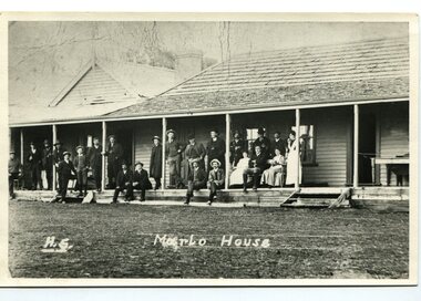
The first settler to occupy the Marlo township area was James Stirling around the year 1875. He built a bark hut on the bluff that had two rooms, bark walls, earthen floors and a shingle roof. By 1884, this structure had expanded to a 9 roomed accommodation house and in 1886 became the Marlo Hotel when a liquor license was granted. The Governor-in-Council declared Marlo to be a township on 18 February 1889. During May 1889, the government surveyor, E.L. Bruce set out 19 sections of the new township, with the first sales of subdivided land occurring the following May. At this time, Stirling's Marlo Hotel was the unofficial hub for the community. It was a general store, accommodation house and the unofficial post office, with settlers taking turns in bringing the mail from Orbost or Cunningham. This continued until Aug 1942, and in 1969 was located in a house adjacent to the Marlo Hotel, before being transferred to the Marlo General Store in this year. The official Post Office List states the Marlo Post Office opened around 1902. in 1925, the "Marlo House" (a nine room accommodation guest house) was granted a liquor licence. The "Marlo House" became "The Marlo Hotel". The Marlo Hotel was popular with many Orbost and district settlers, who travelled to Marlo by horseback or buggy. The Marlo Hotel, perched on the hill overlooking the estuaries and the entrance is a significat building in Marlo. Established in 1886, it has been operating for over 120 yearsA black / white photograph of the Marlo Hotel. Patrons are standing on the verandah and lawns. A horse-drawn carriage is on the left. The photograph is on a green buff card with a rough edge on R H side.on back - " Old Marlo Hotel"marlo-house marlo-hotel stirling-james -
 Orbost & District Historical Society
black and white photograph, C 1900
The first settler to occupy the Marlo township area was James Stirling around the year 1875. He built a bark hut on the bluff that had two rooms, bark walls, earthen floors and a shingle roof. By 1884, this structure had expanded to a 9 roomed accommodation house and in 1886 became the Marlo Hotel when a liquor license was granted. The Governor-in-Council declared Marlo to be a township on 18 February 1889] During May 1889, the government surveyor, E.L. Bruce set out 19 sections of the new township, with the first sales of subdivided land occurring the following May. At this time, Stirling's Marlo Hotel was the unofficial hub for the community. It was a general store, accommodation house and the unofficial post office, with settlers taking turns in bringing the mail from Orbost or Cunningham. This continued until Aug 1942, and in 1969 was located in a house adjacent to the Marlo Hotel, before being transferred to the Marlo General Store in this year. The official Post Office List states the Marlo Post Office opened around 1902. in 1925, the "Marlo House" (a nine room accommodation guest house) was granted a liquor licence. The "Marlo House" became "The Marlo Hotel". The Marlo Hotel was popular with many Orbost and district settlers, who travelled to Marlo by horseback Perched on the hill overlooking the estuaries and the entrance, the Marlo Hotel is a significant building in Marlo. It was established in 1886 and has been operating for over 120 years,A black / white photograph of Marlo House with staff and patrons standing and sitting on the verandah.on front - "H.S. Marlo House"marlo-house marlo-hotel -
 Federation University Historical Collection
Document - Document - Course Outline, VIOSH: Ballarat College of Advanced Education; General Information - Graduate Diploma in Occupational Hazard Management, c1986
Victorian Institute of Occupational Safety and Health (VIOSH) Australia is the Asia-Pacific centre for teaching and research in occupational health and safety (OHS) and is known as one of Australia's leaders in the field. VIOSH has a global reputation for its innovative approach within the field of OHS management. VIOSH had its first intake of students in 1979. At that time the Institution was known as the Ballarat College of Advanced Education. In 1990 it became known as Ballarat University College, then in 1994 as University of Ballarat. It was 2014 that it became Federation University. VIOSH Australia students are safety managers, senior advisors and experienced OHS professionals. They come from all over Australia and industry. Students are taught active research and enquiry; rather than textbook learning and a one-size fits all approach. VIOSH accepts people into the Graduate Diploma of Occupational Hazard Management who have no undergraduate degree - on the basis of extensive work experience and knowledge. Document is General Information on the Graduate Diploma in Occupational Hazard Management. Sections are from a larger fully detailed document. Outlines the structure of the course, Unit Descriptions, Staff, Student Workloads. Student Enrolment Statistics for 1979 to 1985 show the numbers from each state and overseas, employments areas such as government, industry, manufacturing, health, and associations, plus the total applications and enrolments. Thirteen A4 sheets - typed on both sides.viosh, victorian institute of occupational safety and health, ballarat college of advanced education, graduate diploma in occupational hazard management, pg1, objectives of course, admission requirements, structure of course, unit descriptions, student workloads, assessment methods, k brown, dennis else, r gillis, tom norwood, max brooke, r kemp, j harvey, p kelly, l roberts, m torode, derek viner, eric wigglesworth, g fernandez, b lees, r maud, p swan, j blitvich, g bradley, j castleman, r lang, j lowinger, p reid -
 Mission to Seafarers Victoria
Plaque - Opus sectile tablet, 1936
The memorial tablet was unveiled in the St Nicholas chapel at the Port Melbourne mission (Beach Cnr Nott St) on Wednesday 24 June 1936. The ceremony was performed by her nephew, Reverend John Smerger Drought - her sister's son. Another plaque was erected the same month in the Williamstown Institute. (Annual Report 1936) Along with the windows in the St Peter chapel in the Central Institute, those were the 3 memorials similar to the ones erected in memory of Miss Tracy. Miss Ethel Godfrey was born in 1861 at sea on the vessel called Copenhagen. Daughter of a pioneer, and settler Frederick Race Godfrey MLA and subsequently Lay Dean at St Paul's. Ethel Studied in Melbourne and abroad at Brussels and became a singing teacher and performer. In 1906 she took on the role of Honorary General Secretary to create and lead the volunteer organisation "The Ladies Harbour Lights Guild" and subsequently helped establish similar groups in Newcastle, Brisbane, Sydney, Hobart, Adelaide and also established the mission in Southampton in the UK. The structure of the LHLG was used as a model framework by similar groups supporting Missions around Australia and the Globe. A key achievement was the fundraising campaign for the memorial chapel in St Peters built in 1917 by Walter R.Butler. She died the 7 July 1935, and is buried in the St Kilda Cemetery.On her retirement in 1930 after some 25 years, Miss Godfrey together with Chaplain Gurney Goldsmith was recognised in the journal The Church and the Sailor, as a key influence and promoter of the formation of Harbour Lights groups across the suburbs of Melbourne, Victoria and Australia, the Ladies Harbour Lights Guild, Melbourne being the first such auxiliary group in the world.Clay base rectangular plaque with inlaid blue ceramic regular tesserae surrounding the ceramic centre rectangular ceramic panel with inscription and decorative glazed detail tiles. Support is a metal frame with inset wood pieces .To the Glory of God and in memory ops/ a much loved leaderAthel Augusta Godfrey, / one of the founders/ of the ladies Harbour Lights Guild/ of which she was honorary general secretary / Until 1930./ This memorial erected in the year of her death."memorial plaque, plaque, lhlg, port melbourne, chapel, brooks robinson and co, reverend john smerger drought, sectile tablet, opus sectile mosaic, mosaic, ethel augusta godfrey 1861-1935 -
 Orbost & District Historical Society
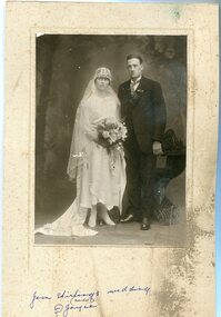
black and white photograph, July 1922
Jean Stirling , born 1901 in Orbost, married Charles Frances Reginald Joyes on 15th July 1922 in Orbost. Jean's father was John Stirling, son of James Stirling and Ann Gray. Her mother was Robina Harvey McNair, Aged 19 James Stirling arrived in Melbourne on January 26, 1842 with his family - parents, three sisters and two brothers. James Stirling moved around a lot to Whittlesea, Ballarat goldfields, Cunninghame, (now Lakes Entrance), then to the Old Station about 36 miles to the east along the coast near the mouth of the Snowy River and for a time settled there with his wife also from Wigton, Scotland, and their family four sons two daughters (James, John, William, George, Margaret and Polly). The first settler to occupy the Marlo township area was James Stirling around the year 1875. He built a bark hut on the bluff that had two rooms, bark walls, earthen floors and a shingle roof. By 1884, this structure had expanded to a 9 roomed accommodation house and in 1886 became the Marlo Hotel when a liquor license was granted. (more information from “Snowy River Mail”, Wednesday, April 13th 1977: MEMORIES OF MARLO by Mrs Elsbeth Conlon (nee Stirling )This photograph is associated with the Stirling family early settlers of Marlo. It is also a pictorial record of styles of wedding dress popular in the 1920s.A black / white studio portrait / photograph of a bridal couple. The bride on the left is wearing a typical 1920s wedding dress. tTe front is short with a hem that is in different length in front than behind. She is wearing a hat in the cloche-style. She is holding a bouquet of flowers and her train is draped to the left. The groom is wearing a three piece morning suit. he has a with a wingtip collar white dress shirt and a cravat tie.on front - hand - written "Jean Stirling's wedding (Marlo) ? Joyce"stirling-jean-wedding melba-&co wedding-clothing-1920s joyes-charles-francis-reginald -
 Ballarat Heritage Services
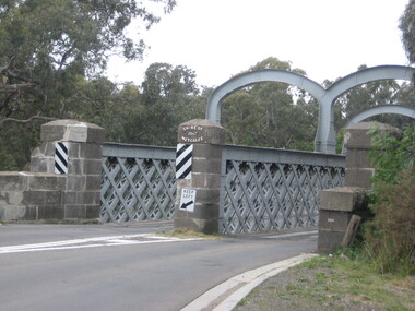
Photograph, Redesdale Bridge, 2016, 18/01/2016
The Redesdale Bridge is a wrought iron and timber structure with bluestone abutments which was installed over the Campaspe River in January 1868, although the bridge actually bears the date 1867. In 1859, the "Herald of the Morning", a ship carrying a cargo including 350 tons of ironwork for the Hawthorn bridge, caught fire and was scuttled a quarter of a mile off the jetty at Sandridge. A Melbourne salvaging firm raised the ironwork from the bottom of the bay, but after details of an arranged sale to the government caused a scandal in Parliament, the material was sold privately to the Melbourne foundry Langlands & Co. Two hundred tons of it was sold to the goldfields shires of McIvor and Metcalfe for only £1000. The bridge was designed by engineer T.B. Muntz and built by a contractor named Doran, and was completed late and considerably over budget at £6274. The bridge spans 45.7m across the river and has two roadways which are carried between three metal lattice girders in a through truss configuration. The design for the Hawthorn bridge had the deck supported over the trusses, and to stiffen the through truss configuration three sets of distinctive paired arches connect the trusses above the roadways. The roadway decking is constructed of longitudinally placed timbers on timber cross girders which rest on the lower chords of the trusses. (Heritage Victoria) A number of colour photographs showing the historic bridge at Metcalfe.metcalfe, shire of metcalfe, bridge, municipal boundary, shire of mcivor, redesdale bridge, campaspe river, t.b. muntz, doran -
 Queenscliffe Maritime Museum
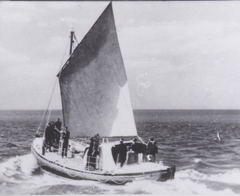
Photograph - Queenscliff Lifeboat under sail, 06 March 1926
The Lifeboat Queenscliffe was built in Adelaide and commenced service at Queenscliff in 1926. She was taken out of service in 1976 by the Marine Board of Victoria and subsequently offered to the Borough of Queenscliffe for care and display. The Lifeboat is listed on the Australian Register of Historic Vessels (ARHV). To view the classification follow the link to the Queenscliffe page on the ARHV site. During her 50 years of service the Queenscliffe attended many calls for assistance both inside and outside the Heads. Some of the vessels and calls for help the lifeboat attended were: 1960 - Army Commandos lost in the Rip 1967 - The search for the late Prime Minister Harold Holt 1974 - The last attendance to a vessel was to the Brisbane Trader which was on fire The shed which housed the lifeboat is located on the Queenscliff 'New' or 'Steamer' Pier (built in 1884). This shed includes the internal section of the slipway used to launch and retrieve the lifeboat. The external slipway and some other structures associated with the lifeboat shed have been removed. Originally fitted with two masts, the stern mast being removed in the 1960's. A retractable centre plate was used when under sail. Delivered with an 80 hp Wayburn petrol motor which was later replaced by a 72 hp Gardiner diesel. Top speed of 7.5 knots and a range of 350 miles.Photograph of lifeboat Queenscliff at sea under sailQueenscliffelifeboat, a. macfarlane & sons -
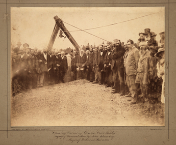 Kew Historical Society Inc
Photograph, Opening Ceremony Victoria Street Bridge: Laying of memorial stone by John Adam Esq. Mayor of Richmond, 1884
A formal group photograph of the grand opening of the Victoria Street Bridge on March 31 1884. The Argus was to report that: ‘The ceremony of laying the memorial stone of the Victoria-bridge, which connects Kew and Hawthorn with Richmond and Collingwood, was performed yesterday afternoon by the mayor of Richmond (Mr John Adam) in the presence of a large assemblage. Among the gentlemen present at yesterday’s proceedings were the mayor of Collingwood (Mr. M. Dwyer), the Mayor of Melbourne (Councillor C. Smith, M.L. A.) the mayor of Kew (Mr. Barnard), Mr. J. A. B. Koch and Mr. W. W. Shelley (ex mayors of Richmond), Mr. Joseph Bosisto, M.L.A., the Hon. L. L. Smith, Councillor De Mole (ex mayor of Kew), Mr. Jas. Lancashire and Mr. Winter (ex mayors of Ricmond), Mr. Walker (ex mayors of Collingwood), Mr. Johnson (engineer), Mr. C. Rowan, C.E. (engineer of the bridge alterations) and the town clerks of Richmond, Collingwood and Kew.’ Following the opening ceremony ‘… a ponderous steam roller was driven over the structure, with a view to test, or rather to demonstrate its stability … Most of the gentlemen present walked over the bridge, after which they were grouped by a photographer, with the memorial stone as a central feature, and several views of the scene were taken’.An original, rare silver albumen mounted and titled photograph of an important event in 19th century Melbourne.Original photograph mounted on display card of the opening of the Victoria Street Bridge. The original photograph is very faded and has been enhanced to improve the image's viewability.On the reverse of the card is an indecipherable stamp and an inscription identifying the photographers. "T. W. & C. A. McAlpine Bros, Photographers &., Campbell Parade East Richmond Melbourne March 31.1884victoria street bridge, john adam, m. dwyer, c. smith, barnard, j.a.b. koch, w.w. shelley, bridge, kew, collingwood, l.l. smith, joseph bosisto -
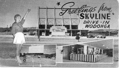 Wodonga & District Historical Society Inc
Photograph - Skyline Drive-in, Wodonga, 1956 - 1985
Inspired by a visit to the USA in the early 1950s, Hoyts' Southern Division manager George Griffith Jnr, formed a syndicate to build Australia’s first Drive-in located in Burwood. Drive-ins soon spread throughout the country. One of the earliest Skyline Drive-ins in rural Victoria was built in Wodonga, opening in 1956. It was located on the southwest corner of Melrose Drive and Melbourne Road and had a capacity of 643 vehicles. Its first screening was "The Broken Lance" with Richard Widmark, Spencer and Robert Wagner. The first manager of Skyline was Jim Robinson. The original screen was made from timber but had to be replaced only 20 years later with an all steel structure. The Wodonga Skyline became part of the Hoyts Country Theatres circuit and was later joined by the Stargazer drive-in located in Albury. Unlike most drive-in theatres, the snack bar was located under the screen. This allowed it to operate during the day to cater to travellers passing on the Hume Highway. When Hoyts decided to sell most of the regional circuit, the Skyline was purchased by the operator of the Albury Cinema, Mr A. Smith in conjunction with Village Roadshow. The Skyline closed in 1984 and was demolished in 1987. Its former location in Wodonga is now a housing estate whose street names, such as Roadshow Drive, Universal Court and Paramount Court, reflect the area’s history.These photos are significant because they document a popular venue in Wodonga's past.A series of photographs depicting the Skyline Drive-in at Wodonga.skyline drive-in, entertainment wodonga, businesses wodonga -
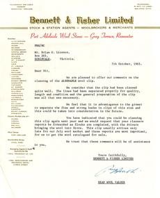 National Wool Museum
Letter - Report, Wool Classing Clip Report, 1965-1966
The National Wool Museum accepted a donation from Brian Licence in 2022 of several mementoes relating to his career in the wool industry. Brian studied Wool Classing and worked for a decade in this profession before moving to Melbourne which required him to change careers. These Wool Classing Clip Reports date from 1965 to 1966, there are 7 total. The reports give feedback to the wool classer about their clips recently classed. They include some suggestions as to how a wool classer may improve their performance, and how a wool grower may be able to increase profits from their flock.8 sheets of paper, slightly under a4 size at 260 x 205 mm. 4 sheets have a header from Elder Smith Goldsbrough Mort Limited, 2 from Bennett & Fisher Limited, and 1 from Roberts, Stewart & Company Limited. All Wool Classing Clip Reports have the same structure, a header from the sending company, a body paragraph of black ink from a typewriter, concluding with a signature at the bottom of the page. Some of the pages have yellowed with age, others have slight tears. Report 1 is by Elder Smith Goldsbrough Mort Limited. It is dated 4th March, 1965. Report 2 is by Bennett & Fisher Limited. It is dated 7th October, 1965. Report 3 is by Bennett & Fisher Limited. It is dated 11th July, 1966. Report 4 is by Roberts, Stewart & Company Limited. It is dated 12th July, 1965. Report 5 is by Elder Smith Goldsbrough Mort Limited. It is dated 9th November, 1965. Report 6 is by Elder Smith Goldsbrough Mort Limited. It is dated 5th July, 1965. Report 7 is by Elder Smith Goldsbrough Mort Limited. It is dated 26th October, 1965.Multiple. See Multimediawool classing -
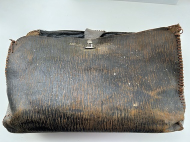 Moorabbin Air Museum
Accessory (Item) - Leather Satchel Marked With Associated Airlines - Melbourne
-
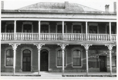 The Beechworth Burke Museum
Photograph - Two Photographs, Saunders, 1864-1972
Taken some time after 1864, these photographs depict the Star Hotel both directly (8674.1) and from the Hotel north west down Ford Street (8674.2). The images depict the building with its modern exterior, having settled for this brick form after several other building designs. The Star Hotel was the first hotel opened in Beechworth, and would go through a series of dramatic changes under its first three owners. The original timber structure was built by W.H. Neuber, though at the time it was only known as ‘The Beechworth Hotel’. The site was later purchased in 1855 by mining entrepreneur, and prolific business owner, John Alston “Six Stars” Wallace. He would go on to extend the established hotel, rebuilding much of it with weatherboard and a shingled roof, adding a two storey structure with a verandah and a theatre capable of supporting 400-500 people, which was often used for international performances. Renamed as the Star Hotel, it was the second in a chain franchise, eventually leading to the “Six Stars” moniker Wallace went by, with hotels at Rutherglen, Chiltern, Yackandandah, Bright, Snake Valley, and of course, Beechworth. Under his ownership, it developed into a popular location for merchants, wayfarers, and locals alike, with the help of his brother Peter as manager. Situated on a road once synonymous with Melbourne to Sydney roadtrips, and the allure of the gold mines, the popularity of the Star drew all manner of clientele from across the country. As such a central hub, the ‘Star Assembly Rooms’ were used as a meeting place for debates, discussions, festivities, and problem solving among the various working sects of the area. These meetings included shareholder discussions for prospecting companies, railway planning, council meetings, and discussions surrounding the interactions between European and Chinese miners, both good and bad. By late 1856, John had the Beechworth at auction through J.H. Grey & Co. It was most likely due to the high profile murder of the manager, Robert Murdoch, during an altercation in relation to a dine and dash event by a Swedish miner, Charles Jansen, who had been ‘excited by drink’ on November 17th. He had refused to pay for his meal and waiter James Mitchell failed to persuade him otherwise. Mitchell, or possibly Murdoch himself, forced him out as tempers and threats escalated. As the photos tell, there are a number of doors which may be entered through, and Jansen used an alternate entrance to access the building. Murdoch was investigating the noise when he encountered the furious man. He was subsequently stabbed with no warning by a small clasp knife, as he tried to stop the intrusion. His exclamations, "I’m stabbed, I’m stabbed!” alerting other occupants, and Jansen was restrained and arrested. Murdoch died the next day from his injuries, with the inquest carried out on the theatre stage. Some 3000 members of the town attended the funeral, and the Star hung black cloth in memory of Robert and his death. Afterwards, an auction caw the property pass to Messrs Robertson and Quirk, though would return shortly thereafter to Six Stars’ portfolio. Six Stars would later sell off his properties from 1862, with the Beechworth Star purchased by 1864 by John Sitch Clark. This allowed Clark to redevelop a significant portion of the Hotel, stripping a central section and constructing the brick structure that survives today, reopening the Star in July that year. It was after this time that our photographs were taken. Clark would later sell the property to Frank Mitchell, shortly before his own death. The next owner, Frederick Allen, lived on the property before the deed was sold to him in the 1880s. He would later sell the property to William Carroll in 1890, with proprietorship eventually moving to Mr. W.H. Porter, and transferring to a Mr. Marendaz by 1913 and Mr. Holly in 1915. Licensing disputes would arise 1917 between Margaret Carroll and a Mrs. McDonald, before it became delicenced some years prior to 1935. It was around this year that the property was bought by Mr. W.J. Pemberton at the meagre price of £500, down from the £13,000 Six Stars originally auctioned it for. It served as a Youth Hostel for a period of time around 1972, and currently the building serves as a private accommodation on the second floor, with shops taking up the ground floor level.These photographs of the Beechworth Star Hotel as they depict a form of Beechworth's first hotel, and also the site of a high profile murder. Two black and white rectangular photographs printed on matte photographic paper.8674.1 (reverse) Beechworth/ 734/ Tanswell’s Hotel [crossed out]/? Old Star/ Hotel,/[small pencil scratching]/ Saunders/ BMM 8674.1 8674.2 (reverse) Beechworth/ 60%[circled]/ Old Star Hotel/Building etc.,/ 12 ½ cm/ 3"[circled, arrows extending horizontally to edges]/[arrows extending top to bottom mid-right of reverse]/ Saunders/ 734[circled]/ BMM 867.2,/ [thin scribbled bordering around top, right, and bottom edges]star hotel, beechworth hotel, john alston wallace, ja wallace, john sitch clark, frederick allen, robert murdoch, meeting place, tragedy, theatre, mining town -
 Ringwood and District Historical Society
Book, City of Ringwood, City of Ringwood 1994 Report & Community Guide, 1994
The City of Ringwood and the City of Croydon merged in December 1994 and became the City of Maroondah.Community information book issued by City of Ringwood for 1994 - covering the facilities and activities of the Ringwood Council and other local organisations and associations. Includes Ringwood Public Golf Course discount vouchers and two Ringwood Aquatic Centre bonus entry vouchers.CONTENTS: (page no.) Contents A Message from the Mayor - Cr. Margaret Cheevers 3 Your Council 4 Local State and Federal MPs 5 Council Meetings and Elections 6 History of Ringwood 7 City Manager's Report 8 Organisational structure 9 Human Services 10-19 Environmental Health 20-21 Ringwood Library 22 Parks and Gardens 23 Ringwood's Parks and Reserves 24 Building 25 Engineering Planning Services 26-28 Waste Management 29 Town Planning 30 Traffic and Local Laws 31-33 Roads, Drainage and Major Works 38-39 Halls and Facilities 40-41 Aquatic Centre 42 Convention Centre/Karralika Theatre 43 Golf Course 44 Free Swim & Golf Discount Vouchers 45 Community Organisations 46-64 Finance 65-66 Administration 67 Community Liaison 68 Information Systems 69 Personnel 70-71 Risk Management 71 Rates and Valuations 72 rinx -
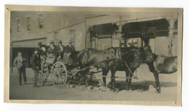 Orbost & District Historical Society
black and white photograph, C 1920s
The photograph shows the coach owned by Mr Tom Malinn of Sardine Creek. It is in front of the Orbost Club Hotel in Nicholson Street, Orbost. On lst Juy 1926, Tom Malin took over the horse drawn coach run from Orbost to Delegate. After a few years he obtained an International 2-3 ton truck. On his first trip to Bendoc he did not carry mail, but brought Miss Cunning, the first lady head teacher and collected ballot boxes. On his next trip (March 1930) he made history as the first mailman on this route to deliver mail in a motor vehicle. (info. Bendoc History) Tom and Sophie Malinn farmed at Martin’s Creek. Sophie (nee Jensen) married Tom Malinn in 1926. Sophie’s family had run the historic “Danebo Hotel” at Martin’s Creek for many years, and in 1931, Tom and Sophie began farming at Martin’s Creek, initially cropping maize and beans. The first hotel built in Orbost was the Club in 1885, an old wooden place on the corner built for J. A. Petersen of the Mitchell Hotel Bairnsdale, now known as the Victoria Hotel. Tom Maguire, a stepson of the late Mr. Petersen, carried on the club Hotel Orbost for 5 or 6 years. The property then came into the possession of Alfred Cooper, a Yorkshireman who purchased the freehold about 1890, pulled the building down and erected the present structure.This is a pictorial history horse-drawn transport used widely in Orbost until the late 1920sA black / white photograph of a horse-drawn buggy with four men on the buggy and two mmen standing beside it, It is in front of the Orbost Club Hotel in Nicholson Street, Orbost..on back - "Tom Malinn on coach run"malinn-tom club-hotel-orbost transport-orbost -
 Federation University Historical Collection
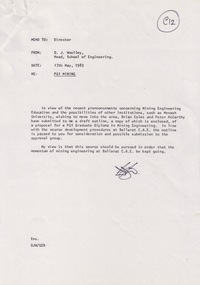
Document - Document - Proposal, VIOSH: Ballarat College of Advanced Education; Proposal for PGI Graduate Diploma in Mining Engineering, 1983
Victorian Institute of Occupational Safety and Health (VIOSH) Australia is the Asia-Pacific centre for teaching and research in occupational health and safety (OHS) and is known as one of Australia's leaders on the field. VIOSH has a global reputation for its innovative approach within the field of OHS management. VIOSH had its first intake of students in 1979. At that time the Institution was known as the Ballarat College of Advanced Education. In 1990 it became known as Ballarat University College, then in 1994 as University of Ballarat. It was 2014 that it became Federation University. VIOSH Australia students are safety managers, senior advisors and experienced OHS professionals. They come from all over Australia and industry. Students are taught active research and enquiry; rather than textbook learning and a one-size fits all approach. VIOSH accepts people into the Graduate Diploma of Occupational Hazard Management who have no undergraduate degree - on the basis of extensive work experience and knowledge. Due to recent pronouncements concerning Mining Engineering Education and the possibilities of other institutions wishing to introduce it, Brian Coles and Peter McCarthy submitted a draft outline of a proposal for a PGI Graduate Diploma in Mining Engineering to Derek Woolley.The outline of this was passed on to allow other to consider and comment on. It outlines the rationale, course structure, course content - core and options, student demand and resource implications. ".... view is that this course should be pursued in order that the momentum of mining engineering at Ballarat C.A.E be kept going". PGI - Post Graduate Institute.Four A4 pages - 3 typed, 1 with newspaper articleThe Weekend Australian May 7-8 1983 RMIT advertisementviosh, victorian institute of occupational safety and health, ballarat college of advanced education, derek woolley, director, brian coles, peter mccarthy, pgi, graduate diploma in mining engineering, post graduate institute, mining engineering education, proposal -
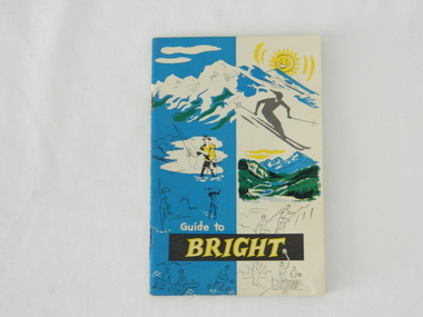 Kiewa Valley Historical Society
Pamphlet - Bright Tourism, Guide to Bright and District, late 1900s
This publication was produced in the early 1950s to provide the growing tourism trade (at this time), to the region with a more detailed overview of the facilities available to tourists of the region's attractions. This brochure is a very efficient and effective promotional publication. The increasing level of self promotion by local business and commerce sectors of the region the more sought after the region became and the greater the ability of the region to grow (non rural based economy). Some of the regions unique facilities and geological structures are well suited to those tourists who live in cities and "flat land" regional bush areas within Australia. This was a period when the average Australian domestic tourist was more able (finance and transport wise) to see more of their country within the short time they had for "holidays". In the late 1900s, however, with the increase to workers' recreational leave and better transportation (fares, ease of travel to overseas destinations) the local tourism numbers from other domestic locations have been steadily declining. From the 1970s onwards, the increased tourism demand from overseas tourists, for better facilities and easier access to these regional facilities, resulted in better transport, accommodation and communication, which has been a boon for all tourism within Australia. In the 21st century the world is becoming smaller and smaller for the international tourist, especially for those from crowded Asian cities. The greater attraction for "open" spaced locations such as this region are becoming a much sought after change of scenery. This pamphlet which targets the tourist, whether either from other Australian regions or the global tourist, is a good example of self promotion by a relatively small local population. This is especially significant because before the "tourist explosion" in the 1950s onward, these regional areas had a more introspective society with greater emphasis to locally established mores and values. The increased interactions with people from other areas and nations, combined with a greater global communication network is affecting those traditionally established mores to produce a some what unique social transformation which is constantly changing from one generation to the next. One important factor which tourism does bring is that it opens up the region to a wider range of people who look to the region for their own lifestyle changes.This pamphlet has a front cover in colour with the major activities in the region sketched depicting : sunshine, snow skiing, trout fishing, mountain climbing, golfing, swimming, alpine views, tennis, lawn bowls and picnics. The back cover is blank. The pamphlet is fastened together by two staples 30mm from top and bottom, and is folded with the cover slightly thicker than the fifteen pages. Thirteen pages have been printed on both sides. The first page has a black and white photograph of the hotel Alpine and the tall brick constructed Clock Tower. There are another five black and white photographs in the pamphlet.on front cover "Guide to BRIGHT"local tourism, regional information booklet, "time" related brochures, alpine local history -
 Glen Eira Historical Society
Book - CAULFIELD CENTENARY 1957
This file contains four items 1/Two copies of a twenty-four page booklet titled CITY OF CAULFIELD CENTENARY 1857-1957, created by the Caulfield City Council and printed by Peter Isaacson Pty Limited, Melbourne. The booklet details important aspects of Caulfield’s history including council procedures, the Caulfield Road District Proclamation, the first election and a summary of 100 years of local government with a description of the present Caulfield in 1957. The booklet also includes several pictures of various Caulfield landmarks and people including one of Caulfield City Councillors (11 men and 1 woman). Also one photocopied version of this booklet. 2/Eleven pages of typed notes for the City of Caulfield Centenary booklet. All notes are undated and incomplete. Two pages titled NOTES on THE HISTORY and PROGRESS OF THE CITY OF CAULFIELD, author unknown. Three and a half pages titled THE STRUCTURE OF LOCAL GOVERNMENT IN VICTORIA, author unknown. Five pages titled 100 YEARS OF LOCAL GOVERNMENT – EARLY CAULFIELD, by Mrs A. P. Bell. 3/A typed letter to Miss V. Webb-Langdon from the Town Clerk H.G. Nelson, acknowledging her contribution to historical details for the Caulfield Council’s Centenary booklet, dated 24/12/1957. 4/A handwritten letter and a handwritten note regarding the acquisition of notes for the Caulfield Centenary booklet. The letter is dated 03/08/2006 and the note is dated 09/02/2007.city of caulfield centenary, caulfield road district, sinclair a.j.g., city hall, war memorials, gamble h.a., machin l.r., bunny f.c.d., caulfield park, koornang reserve, parton e.m., sims h.e., thomson w.r., gunn e.e., yorston j.s., wallace g.e. mrs, green w.c., jenner e.r., ward boundaries, dandenong road, queens avenue, normanby road, station street, bond street, glen eira road, orrong road, poath road, north road, booran road, nepean highway, glen huntly road, glenhuntly road, inkerman road, hotham street, nelson h.g., fullard w.r., mackley g.j., ellis k.i, crosbie m.r., nutting b.i., body j.h., pritchard r.j., guildford l.t.g., lund l.m., street h.c., reynolds a.w., elections , political processes, local government, springthorpe reserve, greenmeadows gardens, business and finance, roads and streets, caulfield racecourse, east caulfield reserve, mackinnon reserve, hawthorn road, balaclava road, murrumbeena road, lempriere avenue, victoria street, koornang road, lord reserve, lyons street, murrumbeena reserve, kangaroo road, ormond park, beatty crescent, foch street, packer reserve, oakleigh road, leila road, prices park, bambra road, riley reserve, playgrounds, town hall, maternal and child health centres, truganini road, grange road, senior citizens centre, barkley sir henry, moore david, handasyde gilbert, caulfield school room, harris g.w., semple john, dempsey william, brooks w.a., wilson thomas, lyall william, murrum murrumbeen lifestyle, ‘greenmeadows’ house, lempriere family, aboriginal culture, ‘rippon lea’ house, caulfield john, ‘slaney’s’ home, alma road, paddy’s swamp, racecourse hotel, caulfield technical college, bevan mr., ‘grosmont’, hart john, railways, mansions, ‘rosecraddock’, langdon h. j., caulfield cup, ‘crotonhurst’, webb judge, ‘kilwinning’, service james, ricketson henry, ‘glen eira’, house names, garden vale, ross william murray, ‘ross’s folly’, outer circle railway, caulfield grammar school, davies j. henry, lagdon william, grimwade f.s., loyd charles du plan, hope george, ‘airdrie’, kooyong hill, market gardens, dairies, lady talbot milk supply, jenner family, o’niell college, presentation sisters, glenferrie road, grimwade frederick sheppard, grimwade alice, ‘harlston’, grimwade house, ‘saint aubin’s’, ‘st. aubin’s’, ‘caulfield hall’, caulfield john p.t., st georges road, caulfield military hospital, nursing homes, health establishments, dover street, sports and recreations, rosanna street, ‘cantala’, health services, parks and reserves, community services, town planning, local government finance, local officials and employees -
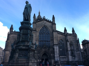 Ballarat Heritage Services
Digital Photograph, St Giles Cathedral, Edinburgh, Scotland, 10/2016
St Giles, also known as the High Kirk of Edinburgh is the principal place of worship for the Church of Scotland. It is very interesting for the mason's marks found on its many stone columns inside the church, and for its connections to the graveyard outside. According to wikipedia, "There is record evidence of a church here, very likely on the present site, in the year 854. In 1120 King Alexander I, rebuilt the church in the Norman style. Of this building characteristic features survived until 1798. During the fourteenth century, Edinburgh was captured and plundered by the English under Edward II. and Edward III., and twice St Giles was laid waste. After restoration, the church was more thoroughly ruined at the Burnt Candlemas in 1387, when Richard II. sacked the city. The western part of the fabric was soon in use again ; but the restoration of the choir and transepts, which were much enlarged, lasted on into the sixteenth century. In 1467 the city endowed St Giles as a collegiate church. It now became usual to speak of the nave, where the stonework was ancient, as the Old Kirk, while the eastern part of the building was called the New Kirk. When the movement for reform drew large crowds to St Giles, separate services began to be regularly held in the Old and New Kirks. Soon this was not enough, and the great church was partitioned off into smaller sections. In 1571 St Giles was seized by Kirkcaldie of Grange, and held by him as a stronghold for Queen Mary. This resulted in serious damage to the structure.Colour photograph of St Giles Cathedral, Edinburgh, Scotlandst giles cathedral, edinburgh, scotland, architecture -
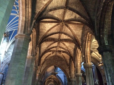 Ballarat Heritage Services
Digital Photograph, Dorothy Wickham, Interior, St Giles Cathedral, Edinburgh, Scotland, 10/2016
St Giles, also known as the High Kirk of Edinburgh is the principal place of worship for the Church of Scotland. It is very interesting for the mason's marks found on its many stone columns inside the church, and for its connections to the graveyard outside. According to wikipedia, "There is record evidence of a church here, very likely on the present site, in the year 854. In 1120 King Alexander I, rebuilt the church in the Norman style. Of this building characteristic features survived until 1798. During the fourteenth century, Edinburgh was captured and plundered by the English under Edward II. and Edward III., and twice St Giles was laid waste. After restoration, the church was more thoroughly ruined at the Burnt Candlemas in 1387, when Richard II. sacked the city. The western part of the fabric was soon in use again ; but the restoration of the choir and transepts, which were much enlarged, lasted on into the sixteenth century. In 1467 the city endowed St Giles as a collegiate church. It now became usual to speak of the nave, where the stonework was ancient, as the Old Kirk, while the eastern part of the building was called the New Kirk. When the movement for reform drew large crowds to St Giles, separate services began to be regularly held in the Old and New Kirks. Soon this was not enough, and the great church was partitioned off into smaller sections. In 1571 St Giles was seized by Kirkcaldie of Grange, and held by him as a stronghold for Queen Mary. This resulted in serious damage to the structure.Two colour photographs of the interior if St Giles Cathedral, Edinburgh, Scotlandst giles cathedral, architecture, mason's marks, stonemasons, church of scotland -
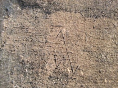 Ballarat Heritage Services
Digital Photograph, Stonemason's marks, St Giles Cathedral, Edinburgh, Scotland, 10/2016
St Giles, also known as the High Kirk of Edinburgh is the principal place of worship for the Church of Scotland. It is very interesting for the mason's marks found on its many stone columns inside the church, and for its connections to the graveyard outside. According to wikipedia, "There is record evidence of a church here, very likely on the present site, in the year 854. In 1120 King Alexander I, rebuilt the church in the Norman style. Of this building characteristic features survived until 1798. During the fourteenth century, Edinburgh was captured and plundered by the English under Edward II. and Edward III., and twice St Giles was laid waste. After restoration, the church was more thoroughly ruined at the Burnt Candlemas in 1387, when Richard II. sacked the city. The western part of the fabric was soon in use again ; but the restoration of the choir and transepts, which were much enlarged, lasted on into the sixteenth century. In 1467 the city endowed St Giles as a collegiate church. It now became usual to speak of the nave, where the stonework was ancient, as the Old Kirk, while the eastern part of the building was called the New Kirk. When the movement for reform drew large crowds to St Giles, separate services began to be regularly held in the Old and New Kirks. Soon this was not enough, and the great church was partitioned off into smaller sections. In 1571 St Giles was seized by Kirkcaldie of Grange, and held by him as a stronghold for Queen Mary. This resulted in serious damage to the structure.Colour photographs of tonemason's marks, St Giles Cathedral, Edinburgh, Scotlandmason's marks, st giles cathedral -
 Ballarat Heritage Services
Photograph - Digital Photograph, Stonemason's marks, St Giles Cathedral, Edinburgh, Scotland, 10/2016
St Giles, also known as the High Kirk of Edinburgh is the principal place of worship for the Church of Scotland. It is very interesting for the mason's marks found on its many stone columns inside the church, and for its connections to the graveyard outside. According to wikipedia, "There is record evidence of a church here, very likely on the present site, in the year 854. In 1120 King Alexander I, rebuilt the church in the Norman style. Of this building characteristic features survived until 1798. During the fourteenth century, Edinburgh was captured and plundered by the English under Edward II. and Edward III., and twice St Giles was laid waste. After restoration, the church was more thoroughly ruined at the Burnt Candlemas in 1387, when Richard II. sacked the city. The western part of the fabric was soon in use again ; but the restoration of the choir and transepts, which were much enlarged, lasted on into the sixteenth century. In 1467 the city endowed St Giles as a collegiate church. It now became usual to speak of the nave, where the stonework was ancient, as the Old Kirk, while the eastern part of the building was called the New Kirk. When the movement for reform drew large crowds to St Giles, separate services began to be regularly held in the Old and New Kirks. Soon this was not enough, and the great church was partitioned off into smaller sections. In 1571 St Giles was seized by Kirkcaldie of Grange, and held by him as a stronghold for Queen Mary. This resulted in serious damage to the structure.Three photographs of stonemason's marks, St Giles Cathedral, Edinburgh, Scotlandmason's marks, st giles cathedral -
 Ballarat Heritage Services
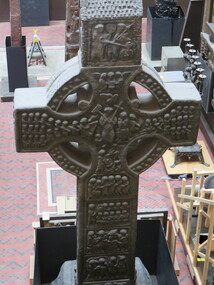
Digital Photograph, Dorothy Wickham, The Cast Courts, 2016, 09/2016
This ornate cross sits at the right hand side of View of Trajan's column, Cast Courts, Room 46a, The West Court, Victoria and Albert Museum, London. Cast Courts: "When the Architectural Courts – or Cast Courts as they are now known – opened in 1873, The Builder magazine compared the experience of seeing them to a first glimpse of Mont Blanc, creating one of those 'impressions that can scarcely be effaced'. Since then, these two enormous rooms and the reproductions they contain have continued to impress and inspire visitors to the Museum. For centuries, antiquarian interest in world architecture and sculpture led to reproductions – or copies – being made of outstanding national monuments and notable sculptures. When the Museum was founded, it collected and displayed reproductions of great art and architecture from across the world in order to offer objects for study and tell a complete story of the history of art and design. Casts are made by placing several plaster moulds upon the surface of the original structure. Once hardened and removed, the moulds are then enclosed in an outer casing, the interior coated with a separating agent and the wet plaster poured in. When set, the pieces are then assembled and the joints and surfaces finished off, to make a complete reproduction of the original work. The finished product – as well as being a formidable technical achievement in its own right – enables admirers to study faithful reproductions of important monuments and works of art." Ref: https://www.vam.ac.uk/articles/history-of-the-cast-courtslondon, victoria and albert museum, cast courts -
 Ballarat and District Irish Association
Photograph - Colour, Clare Gervasoni, St Patrick's Cathedral Hall, Ballarat, 2007, 20/11/2007
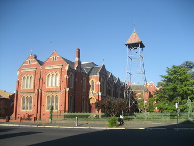
St Patrick's Cathedral Hall was erected in 1900 to the architectural plans of Clegg, Kell and Miller. The builder was Peter Bodger. The Cathedral Hall is a massive structure in the Gothic manner, with slender proportions and Gothic window detailing. The main hipped roof of the hall is intersected on both sides by four gables, and the front ridge is intersected by two further gables to form the street elevation. Internally the hall resembles many town halls except for the two tiers of Gothic windows and the manner in which the ceiling curves downward towards the walls. Pointed Gothic windows on the upper level intersect the curved ceiling in a simple groined junction. The plaster ceiling is coffered by intersecting beams, while a central skylight floods the hall with natural light. Other features of note are the ridging on the front gables, and the iron bell tower framed in steel angles and braced with criss-crossed rods, complete with a huge wheel and a great bell. St Patrick's Hall demonstrates a notable application of decorative schemes, particularly its highly decorated ceiling which has few parallels amongst other church halls in Victoria. The hall is in an important location as part of St Patrick's complex, as well as part of the group of churches which include St Andrew's Kirk and the former Baptist Church, opposite in Dawson Street. (http://stpatscathedral.weebly.com/cathedral-hall--presbytery.html, accessed 13 November 2013.A series of colour digital photographs showing a large red brick hall associated with St Patrick's Cathedral, Ballarat. The bell tower is situated to the right of the hall.ballarat irish, st patrick's cathedral hall, cathedral hall ballarat, bell, bell tower -
 Parks Victoria - Mount Buffalo Chalet
Plans x 4, " Additions to Government Chalet Mt Buffalo
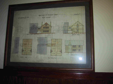
Original plans for the Mount Buffalo Chalet, framed architectural drawings for the Chalet, titled " Additions to Government Chalet Mt Buffalo. Dated 1909. Signed Jas G Spence & E F Leary. "Ground Plan, first floor plan, elevation, Section M5 and side elevation –beautiful coloured plan, hand price onit of £970, also called Drawing No. 1.Beautiful plan suitable for reproduction for graphic work." (Pg 45. Heritage Impact Assessment, September 2013. MGS Architects and McDougall & Vines, Conservation and Heritage Consultants) 'The Mount Buffalo Chalet opened in April 1910 as a remarkable Victorian State government venture into alpine tourism and recreation. Designed by Public works Department architect, George Austin (1860-1921)." (Pg 4 Historica, 2011). "The collection of ephemera builds on the Chalet's holding of archival material with a range of interesting, original items. Dinner menus., stationery., luggage labels, tickets, dockets and plans help to interpret the structured routine and social conventions of the Chalet that held sway for so many years." (pg 127 MBCC) These plans drawn were most likely to have been drawn upon recommendation by Government Tourist Officer, J.C.Boyce. John Newton (the Lessee) suggests the addition of 2 new wings (24 rooms) and creation of a billiards room. Treasury approved money for these extensions which were not completed until1914. Listed in Draft Inventory of Significant Collection Items. Four framed hand-drawn and coloured drawings / plans of the Chalet. Framed and mounted behind glass. 1: Dated 1911 -1912. 2: -dated 6th oct 1909 3: -Dated 25th Sept 1909. 4: -Dated 6th Oct 1909.Handwritten at the top of each drawing," Mount Buffalo / Wood Chalet" -
 Phillip Island and District Historical Society Inc.
Photograph, 1940
Nine photographs from a collection of 33 donated by Leonie Brennan. Photographs belonged to Edward (Ted) Sands, hairdresser.Photograph 215-01 Black & White photograph of 3 people standing in front of Mr Anderson's shop in Cowes. Miss D Winson?? Mr O S Kennedy & Mr R Anderson. Photograph 215-02 Black & White photograph of landing cranes on the Cowes pier. Cowes foreshore and mature trees in background. Photograph 215-03 Black & White photograph of the early construction of Phillip Island bridge viewed from Phillip Island. Shows the base structure of the first bridge. Photograph 215-04 Black & White photograph of the Newhaven - San Remo Punt on the shore on the Phillip Island side. Photograph 215-05 Black & White photograph of Edward (Ted) Sands standing in front of R Anderson's shop in Cowes. Photograph 215-06 Black & White photograph of a koala in tree in front of shed and water tanks. Photograph 215-07 Black & White photograph of the Isle of Wight Hotel showing front footpath and shop next door. Photograph 215-08 Black & White Photograph of the Cowes beach at low tide, showing mature trees on the foreshore and boats in the water. Photograph 215-09 Black & White Photograph of Mr R Anderson's Shop in Cowes.All photographs except for one marked on front with "Cowes" the month and year 1940.cowes shop phillip island, mr anderson, mr o s kennedy, mr edward (ted) sands, isle of wight hotel phillip island, cowes pier phillip island, cowes beach phillip island, newhaven-san remo punt, wildlife - koala, koala cowes phillip island, phillip island first bridge, leonie brennan -
 Ballarat Tramway Museum
Document - Photocopies, Alan Bradley, "Increase of Tramway Fares", "One Man Cars", 18/07/2001 12:00:00 AM
Photocopies of letters made by Alan Bradley in relation to the use of Fare Tokens by the Electric Supply Co. of Victoria - See Reg. Item 1794. Photocopies made 18.07.2001. Photocopies of letters copied by Alan from the City of Ballarat's files. 1801.1 - Photocopy of letter dated 23/9/1921, signed by Mr. Pringle of ESCo to Col. G.F. Morton, City Clerk of the City of Ballaarat concerning the increase of tramway fares and the withdrawal of tokens due to the increase in costs. Gives details of fare structures, costs, tramway wages, section changes, American and English tramway fares and increase in the cost of coal. Three sheets stapled together in top left hand corner. 1801.2 - Photocopy of letter dated 23/7/1913 concerning the introduction of one man tramcars, signed by Mr. Pringle of ESCo, to Col. Williams, City Clerk of the City of Ballarat, and the introduction of celluloid tokens which would replace slip tickets and work better in the Fare Boxes. Also notes the introduction of "screens", windscreens, to all cars. Two sheets stapled together in top left hand corner. See Reg. Item 2514 for H.P. James notes on the token system.Parts of letter have been highlighted by Alan re tokens and other interesting points.trams, tramways, tokens, fares, tickets, esco, windscreens, costs -
 Eltham District Historical Society Inc
Photograph - Digital Photograph, Alan King, Kangaroo Ground Presbyterian Church, 28 December 2007
Built in 1878, the orange polychromatic brick structure replaced a slab building which had been used since 1951. The building has changed little with its handsome bricks buttressed on both sides, a slate roof and a Celtic cross on top of the front gable. The carved wooden pulpit and 18 pews are original. The cathedral-style ceiling is fully lined with tongue-and-groove pine boards and the floor is also pine. The walls have arched oblong leadlight windows. In 1977 the congregaton decided not to join the Uniting Church, whcih amalgamated some Presbyterian churches with all the Methodist and Congregational churches in Australia. Together with the store and school, the church is one of Kangaroo Ground's three public buildings. Covered under Heritage Overlay, Nillumbik Planning Scheme. Published: Nillumbik Now and Then / Marguerite Marshall 2008; photographs Alan King with Marguerite Marshall.; p91 The small Presbyterian church in Main Road, Kangaroo Ground, has been a spiritual centre for more than a century. Built in 1878, the orange polychromatic brick structure replaced a rude slab building, which had been used as both a church and school since 1851. Earliest settlers, who were Scottish farmers, had worshipped together since 1841 in a barn owned by farmer James Donaldson and led by a layman called Smith.1 However, from 1843, the Reverend Peter Gunn conducted church services. Prominent early church members include the Donaldson, Bell and Cameron families. In 1851, Samuel Furphy (father of author Joseph) built their first church building, a 30 feet x 18 feet (9m x 5.5m) slab structure on half an acre (0.2ha) donated by Mr Donaldson. Conditions could be very uncomfortable in extreme weather.The green slabs of timber and sapling logs, covered partly with mud, had centimetre-wide cracks, allowing rain and wind through, when not blocked out by folds of paper.2 However this did not deter the first couple marrying there in 1857: John Wilson of Nillumbik and Christina Macpherson of Christmas Hills. The Reverend Peter Gunn seldom visited so it was usually left to Andrew Ross, the settlement’s first teacher and founder of the newspaper The Evelyn Observer, to lead the divine services instead.3 In 1877 the settlers raised £355/19/- and hired architect, Charles Maplestone and builder, Mr Self, to construct today’s church building. Each family rented a pew or pews for ten shillings a half-year; they also paid quarterly subscriptions for the minister’s stipend.4 It was not until 1886 that the church celebrated its first wedding, that of John Bell (junior) from Violet Bank and Elizabeth Charlton of Cunis Nillen. The Sunday School’s first recorded meeting was also held that year. In 1892 a weatherboard vestry was built, and the following year John Bell donated a church bell, which the fire brigade used as a warning for several years. Conditions have varied greatly during the century. In 1893 the Reverend Darroch had to travel more than 2000 miles (3220km) to attend to his scattered parishioners. Then in the Depression, the minister Mr Brown, subsisted only on lodgings with no stipend. The Sunday School ceased for many years because of the small population, but reopened in 1949. The building has changed little with its handmade bricks buttressed on both long sides, a slate roof and a Celtic cross on top of the front gable. The carved wooden pulpit and 18 pews are original and in fine condition. The cathedral-style ceiling is fully lined with tongue-and-groove pine boards and the floor is also of pine. The walls have arched oblong leadlight windows. One window has stained glass commemorating Mrs Jessie Agnes Cameron and her ancestors – the pioneering Bell family. It depicts The Sower because the family comprised farmers who came to a strange land to sow the seeds of their faith as much as their crops. Thistles signify their Scottish ancestry and the pigeons are a symbol of Pigeon Bank, the Kangaroo Ground farming property where Jessie Cameron was born.5 Other historical ties are seen on two marble memorial tablets and carved wooden chairs dedicated to former members. The Church still has the original Bible with gold edged paper, presented by the women of the congregation in 1871, although it is no longer used. In 1977 the Presbyterian congregation decided not to join the Uniting Church, which amalgamated some Presbyterian churches with all the Methodist and Congregational churches in Australia. Together with the store and school, the church is one of Kangaroo Ground’s three public buildings.This collection of almost 130 photos about places and people within the Shire of Nillumbik, an urban and rural municipality in Melbourne's north, contributes to an understanding of the history of the Shire. Published in 2008 immediately prior to the Black Saturday bushfires of February 7, 2009, it documents sites that were impacted, and in some cases destroyed by the fires. It includes photographs taken especially for the publication, creating a unique time capsule representing the Shire in the early 21st century. It remains the most recent comprehenesive publication devoted to the Shire's history connecting local residents to the past. nillumbik now and then (marshall-king) collection, kangaroo ground presbyterian church -
 Bendigo Historical Society Inc.
Photograph - HILDA HILL COLLECTION: BLACK AND WHITE PHOTOS, 1917-1924
Series of Black & White Photos Total 6 Hill Family & Friends During the First World War and after. Rita, wearing a dark dress with white collar and holding a dark coloured hat, background is large brick structure with windows to right and small section of veranda, pal tree, Railway Reserve Kyneton 1918. Man and two women wearing white dresses and dark hats, man wears dark suit white shirt and dark tie with his back against a large wheel, white sheet on ground between them and indistinguishable articles on sheet, Hibernian Picnic Axedale November 13th 1918. Group of young girls and boys all dressed in light coloured clothing gathering Botanical gardens January 1917, Miss N. Linnane reclining on cane lounge chair on verandah, weatherboard wall of house, verandah post, rock garden edging in foreground, May 1918. Monte Video Property Queensland Jeff, dressed in dark trousers and white shirt, holding a skinned rabbit, water tank in background, wire fence, July 1924. Father & Mother, Father wears a grey suit with white shirt and dark tie, Mother seated is wearing a dark dress with striped collar and white blouse, 'The Ranche' Mollison Street Eppalock.Hilda Hill Personal Collectionaustralia, history, post war life