Showing 179162 items
matching streets
-
 Warrnambool and District Historical Society Inc.
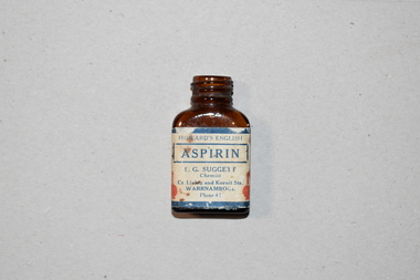
Aspirin Bottle, Howard and Sons, Early 1930s (contents)
This bottle contained aspirin made by the firm of Howard and Sons of England. This firm had its origins in the late 18th century and manufactured pharmaceutical products, especially quinine and aspirin. The latter was used as a painkiller for headaches and minor health problems. The distributor of this bottle of aspirin was Len Suggett, a chemist in Warrnambool. James Barnes established a chemists business in Warrnambool in the mid 1920s and Len Suggett was the manager. After the death of Barnes in 1939 Len Suggett bought the business. The business was at the corner of Liebig and Koroit Streets (102 Liebig Street) until about 1950 when it was moved to another site across the road in Liebig Street.This bottle has local provenance as it came from the pharmacy of Len Suggett who was a well-known businessman in Warrnambool for many years and therefore the item has some significance as a memento of that business. This is a small brown glass bottle. It is empty but originally contained aspirin. The main body of the bottle has a label (white with dark blue edging) covering all sides of the bottle. The label is somewhat stained and frayed. The bottle has no stopper or lid. Howard’s English Aspirin L.G. Suggett Chemist Cr Liebig and Koroit Streets Warrnambool Phone 42 -
 Bendigo Historical Society Inc.
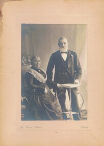
Photograph - MR & MRS J.B.WITTMANN PORTRAIT, cq. 1900
B+W photograph on front mount studio portrait (B+W) of lady seated on upholstered chair (carved wood), man standing behind occasional table. Man is dressed formally (Bow tie and stiff shirt); whiskered- beard & moustache. Inscription: Front: the crown studios Sydney - printed on board. Back: (P.T.O).Back: Handwritten: 'Mr & Mrs Wittmann in later years when/they had gone to live in Sydney. RHSV stamp (Royal Historical Society of Victoria/Bendigo Branch), '1128', Printed by Studio: 'George & Market Streets/Sydney', 'The Crown Bromide Enlargement Coy 'Trade Mark'','The/Crown/Studios','Mark Blow/General/Manager', 'Portrait enlarged/on Bromide,Platinotype/Carbon Opal, and Finished/ in crayon, indian in, partel/water colour or oils',' Telephone No 477','Cable Address 'Bromide'/Sydney',' Copies of this Photograph No__ maybe had at any time'.The Crown Studios, Sydney, George & Market Streetperson, family, wittmann portriat -
 Federation University Historical Collection
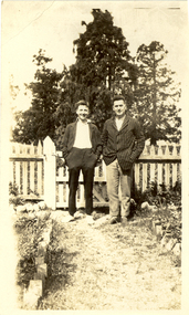
Photograph - Photograph - Black and White, Scotts Pharmacy, Frank Wright and Friend
Frank Wright was a renown resident of Smeaton, where he was born. He lived at Laura Villa, and attended Smeaton State School. His father William was a gold miner and his mother's name was Sarah. Their family won many singing and instrumental awards. Frank was tutored by Percy Code and was awarded a gold medal for the highest marks in the ALCM examinations in the British Colonies at the age of seventeen years. He became the Australian Open Cornet Champion by the age of eighteen. A year later, Frank conducted the City of Ballarat Band, and later the Ballarat Soldiers’ Memorial Band. He formed the Frank Wright Frisco Band and Frank Wright and his Coliseum Orchestra. These bands won many South Street awards, and Frank as conductor won many awards in the Australian Band Championship contest. In 1933 Frank Wright sailed to England to conduct the famous St Hilda’s Band and was later appointed Musical Director of the London County Council, where he organized many amazing concerts in parks, in and around the London district. He was made Professor of Brass and Military Band Scoring and conducted at the Guildhall of Music and Drama. Frank was often invited to adjudicate Brass Band Championships around Europe, in Australia, including South Street and in New Zealand. The Frank Wright Medal at the Royal South Street competition is awarded to an individual recognized as making an outstanding contribution to brass music in Australia.Black and white photograph of two men standing on a path inside a fenced garden. There are tall trees in the background. The men are Frank Wright and a friend, possibly at "Laura Villa" Smeaton.Stamped on the back - Printed at Scott's Pharmacy, (143) Sturt Street Ballaratfrank wright, cornet, conductor, ballarat, laura villa -
 Marysville & District Historical Society
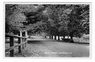
Photograph (Item) - Black and white photograph, Valentine Publishing Co. Pty. Ltd, Main Street, Marysville. No.4, 1923-1963
An early black and white photograph of the main street in Marysville in Victoria. An early black and white photograph of the main street in Marysville in Victoria. That street is now known as Murchison Street. This photograph was produced by the Valentine Publishing Co. Pty. Ltd. as a souvenir of Marysville.marysville, victoria, murchison street, souvenir, valentine publishing co, photograph -
 Port Melbourne Historical & Preservation Society
Card - Remembrance greeting card, 1900s
In a box dug up during renovations at 78 Station StreetFrom a box of objects dug up at 78 Station Street:,dating early to mid 1900s: .01 greeting card "Remembrance"domestic life -
 Kew Historical Society Inc
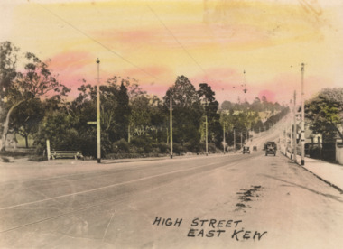
Postcard - High Street, East Kew, c.1927
High Street, Kew is the main Road in Kew. It was once also known as Bulleen Road, or Main Street. This section of the road is in Kew, although the narrow section on the right hand side of the photo is now Kew East. High Street progresses through a number of significant road junctions: beginning at Barkers Road; progressing through the intersection of Studley Park Road, Denmark Street and Princess Street at Kew Junction; branching left at the junction with Cotham Road; before reaching the junction with Valerie Street and Harp Road. It reaches its end at the junction of Burke Road, Kilby Road, Bulleen Road and High Street itself. An early photograph of this iconic Memorial that locates it in its context. Small, colorised real photo postcard of High Street, East Kew. Electric light poles line the road. Victoria Park is on the left and further on the horizon is the Boroondara General Cemetery.high street -- kew (vic.), victoria park, tram lines -- kew (vic.) -
 Ringwood and District Historical Society
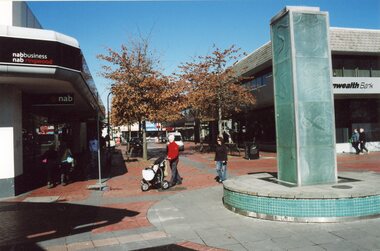
Photograph, Melbourne Street Mall, c2000
Colour photographs (16)Various street scenes within the Melbourne Street Mall -
 Eltham District Historical Society Inc
Photograph, First house in Pryor Street, Eltham, c.1965, 1965c
... streets ...This was the first house on Pryor Street which was located at the corner of what is now Commercial Place on the eastern side. Originally there was another house adjacent but it had been moved by the time of the 1951 aerial survey. The house was also the first home of Russell Yeoman who had been newly appointed to the Shire of Eltham and this house belonging to the council was vacant and made available to him for four weeks before it was relocated to Susan Street just south of the bowls club and was used a child care centre associated with the Living and Learning Centre (Russell believes). Russell then moved into another council owned house at the corner of Susan and Bridge Streets.Digital file only; created from original colour positive slide transparencyeltham, streets, houses, pryor street, susan street, fe holden sedan, russell yeoman collection -
 Eltham District Historical Society Inc
Photograph, First house in Pryor Street, Eltham, c.1965, 1965c
... streets ...This was the first house on Pryor Street which was located at the corner of what is now Commercial Place on the eastern side. Originally there was another house adjacent but it had been moved by the time of the 1951 aerial survey. The house was also the first home of Russell Yeoman who had been newly appointed to the Shire of Eltham and this house belonging to the council was vacant and made available to him for four weeks before it was relocated to Susan Street just south of the bowls club and was used a child care centre associated with the Living and Learning Centre (Russell believes). Russell then moved into another council owned house at the corner of Susan and Bridge Streets.Digital file only; created from original colour positive slide transparencyeltham, streets, houses, pryor street, susan street, russell yeoman collection, fc holden sedan -
 Clunes Museum
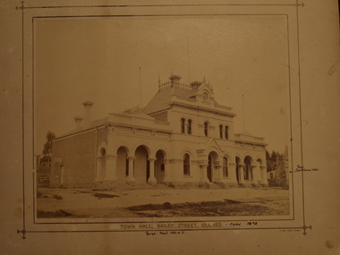
Photograph - PHOTOGRAPH - TOWN HALL 1872, J MEEK
TOWN HALL AND COURT HOUSE IN BAILEY STREET, CLUNES PHOTOGRAPH OF CLUNES TOWN HALL AND COURT HOUSE .1 SEPIA PHOTOGRAPH .2 COPY OF PHOTOGRAPHPRINTED: TOWNHALL BAILEY STREET, CLUNES HANDWRITTEN: ERECTED 1872, PERIOD ABOUT 1881-1882 REAR COURTHOUSE HOTELlocal history, photography, town hall -
 Marysville & District Historical Society
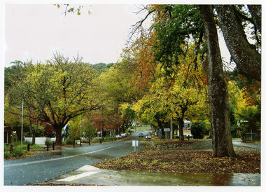
Photograph (Item) - Colour photograph, Unknown
A colour photograph of Murchison Street in Marysville in Victoria.A colour photograph of Murchison Street in Marysville in Victoria.murchison street, marysville, victoria, photograph -
 Federation University Historical Collection
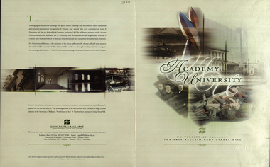
Booklet, From Academy to University, 2001, 2001
Four page signed copy of a booklet concerning the University of Ballarat Art Campus at Camp Street. On back page - "Amidst the fevered atmosphere of multi-cultural settlement and the rush for gold, Ballarat's passion for the arts was born. The founding schools of art have evolved over 130 years to forge a proud identity in the University of Ballarat's 'New School of Arts'. The arts have returned to Camp Street Hill."arts academy, camp street, autographs, david karmouche, kerry cox, pamela davies, rosie mcgregor, tim broome, bill pryor, pater r. wilson, gerry anderson, robert hook, david james, terry lloyd, camp street hill -
 Melbourne Legacy
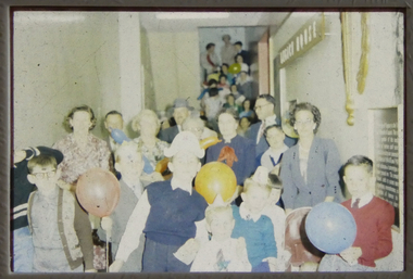
Slide, Legacy House in Market Street, 1950s
Two slide images of the staircase in the old Legacy House in Market Street, probably from the 1950s. It shows children and people gathered together, some are holding balloons and some have party hats on. Legacy rented the Market St premises for many years. It was part of the Western Market complex that was demolished and redeveloped in the early 1960s. Legacy held meetings, activities and the girls classes on the second floor of the building, accessed by this staircase, but it was barely fit for purpose. In the 1940s a generous donation by an anonymous donor meant Legacy could purchase a building at 342 Swanston St, but due to several factors were never able to inhabit it. Finally it was sold in 1954 and Junior Legacy Melbourne purchased 289-299 Swanston Street Melbourne (previously called Red Cross House) in 1956 from the Commonwealth Government.A record of the Market Street building that Legacy occupied for many years until 1956-7.Colour slide x 2 of the staircase at Legacy House in Market Street.properties, market st -
Port Melbourne Historical & Preservation Society
Container - Bottle, Swallow and Ariell salad dressing, excavated from cesspit at All England Eleven Hotel, 1850s - 1860s
Dug from ground at demolished 282 Rouse Street in 1999 and donated by Peter LIBBISS&A salad dressing bottle from group of 1850/1860s bottles dug up at 282 Rouse Street in 1999:S&Adomestic life - containers, business and traders - hotels, all england eleven hotel -
 Kew Historical Society Inc
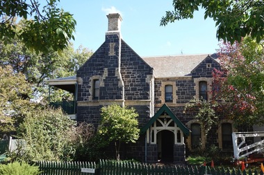
Photograph - Digital Photograph, Robert Baker, Vicarage of Holy Trinity Church (Kew), 2013
The Vicarage at Holy Trinity Church in Kew faces Pakington Street. It was designed by the architect Charles Vickers. Th building has been 'restored' at various stages in the 20th century.Born digital image of the facade of the bluestone vicarage in Pakington Street (Kew), designed by Charles Vickers. holy trinity church - kew (vic), churches - vicarages - kew (vic), charles vickers -
Port Melbourne Historical & Preservation Society
Book - Melway Greater Melbourne Street Directory, Melway, 1990 - 2009
... streets ...Four editions of Melway Greater Melbourne Street Directory .01 Edition 20 (1990) - Reg Yellow and green vertical banded cover .02 Edition 24 (1994) - Green, orange, white cover .03 Edition 32 (2005) - Dark and light blue cover .04 Edition 36 (2009) - White, red and black coverbuilt environment, engineering - roads streets lanes and footpaths, natural environment, transport - roads, melbourne, streets, mapping -
 Wodonga & District Historical Society Inc
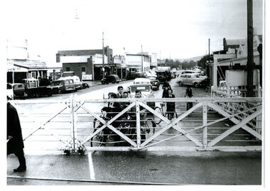
Photograph - High Street, Wodonga Level Crossing, 1954
This image is representative of many photographs illustrating the level crossing in the centre of Wodonga. Since its opening in 1873 the railway line had crossed High Street, originally called Sydney Road. It bisected the city with level crossing gates frequently stopping the flow of traffic and pedestrians as trains passed through. Signal Box B stood on the eastern side of the High Street level crossing and a big wheel closed and opened the gates. On 17th September, 1961, it was replaced by boom gates and flashing lights. The railway crossing was removed from High Street as part of the Wodonga Rail Bypass project. This involved a 5.5 kilometres bypass, the elimination of 11 level crossings and the relocation of the Wodonga station. It was moved from its original central location to a position on a new line on the northern edge of the town. The old station closed on 8 November 2008 and the new station opened on 25 June 2011.This image has local and statewide significance as it captures the former crossing in a major railway system. The railways played a critical role in opening up Victoria and connecting Australia for trade, business, social communication and transport.A black and white photo of the railway level crossing in High Street, Wodonga with gates closed. The Melbourne to Sydney railway line went through the centre of Wodonga and trains frequently held up internal vehicular and pedestrian traffic in the main street. railways wodonga, wodonga railway relocation, high st wodonga rail crossing -
 Orbost & District Historical Society
black and white photograph, 1960s - 1970s
This photograph shows the former Orbost Police Station in Wolseley Street before it was demolished and a new larger brick building was built behind it in Lawson Lane - late 1980s.This is a pictorial record of a significant community building no longer existing.A large black / white photograph of the Orbost township police station. It is a weatherboard building surrounded by trees. A sign "POLICE" is hanging from a pole.on back - " Orbost Police Station in Wolseley Street, Donated by Debbie Hall 31/8/94"orbost-police-station -
 Bacchus Marsh & District Historical Society
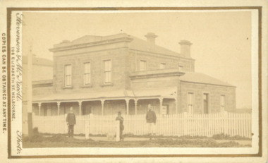
Photograph, Court House Main Street Bacchus Marsh 1883
The Court House in Main Street Bacchus Marsh was built in 1858 using local sandstone. It opened in 1859. It has been used for jury trials, a Court of Petty Sessions, a County Court and a Crown Land sales office. Other uses included an office for the Registrar of Births and Deaths, a Diary Inspectors office from 1863-1865, and as meeting rooms for the Bacchus Marsh Roads Board, a forerunner of the Shire Council. It was also used by the Bacchus Marsh Shire Council for its offices until at least 1884. In more recent years it has functioned as a Magistrates Court with weekly court sessions. Small sepia unframed photograph on card with gold border framing photograph. Housed in the album, 'Photographs of Bacchus Marsh and District in 1883 by Stevenson and McNicoll'. The view of the Court House building is seen from the northern side of Main Street looking south or south-east. Three men are standing in of the street in front of the building. The men on the left and the right appear to be police officers. The man in the middle is in civilian clothes and might be an officer or employee of the Court House. A white picket fence is in front of the building. This is no longer present.On the front: Stevenson & McNicoll. Photo. 108 Elizabeth St. Melbourne. COPIES CAN BE OBTAINED AT ANY TIME. On the back: LIGHT & TRUTH inscribed on a banner surmounted by a representation of the rising sun. Copies of this Portrait can be had at any time by sending the Name and Post Office Money Order or Stamps for the amount of order to STEVENSON & McNICOLL LATE BENSON & STEVENSON, Photographers. 108 Elizabeth Street, MELBOURNE. stevenson and mcnicoll 1883 photographs of bacchus marsh and district, courthouses, bacchus marsh court house -
Tatura Irrigation & Wartime Camps Museum
Folder, Tatura Revitalisation Committee, The Tatura Heritage Mosaics Art Work, 2010
Information on the Mosaics artwork in Francis Street, Tatura. Ref. L1058, L105918 x A4 pages describing the content of the mosaics in Francis Street. Includes colour photographs and notes on some of the people pictured.Colour pictures of the mosaic art. History of its implementation. Some brief biographies of those pictured.tatura art work, tatura mosaics, francis street tatura victoria -
 Tatura Irrigation & Wartime Camps Museum
Photograph, Shire Office and Library, Casey Street, Tatura
Shows picture of the former Shire office and Library in Casey Street, Tatura. Colour photograph showing former Shire Office and Library in Casey Street, Tatura. Photograph stuck onto piece of white cardboard. shire office tatura, tatura library, casey street tatura -
 Tatura Irrigation & Wartime Camps Museum
Photograph, Goulburn Murray Water Tatura
Shows picture of the premises of Goulburn Murray Water, Casey Street, Tatura. Colour photograph showing the premises of Goulburn Murray Water, Casey Street, Tatura. Photograph stuck onto piece of white cardboard. tatura victoria, tatura businesses, goulburn murray water -
 Tatura Irrigation & Wartime Camps Museum
Photograph, Casey Street Tatura
Shows picture of the view looking west along Casey Street, Tatura. Colour photograph showing view looking west along Casey Street, Tatura. Photograph stuck onto piece of white cardboard. tatura victoria, casey street tatura -
 Tatura Irrigation & Wartime Camps Museum
Photograph, Sacred Heart Church Tatura
Shows picture of the Sacred Heart Catholic Church, Hogan Street, Tatura. Colour photograph showing the Sacred Heart Catholic Church, Hogan Street, Tatura. Photograph stuck onto piece of white cardboard. tatura victoria, sacred heart catholic church tatura, hogan street tatura, catholic church tatura, tatura churches -
Whitehorse Historical Society Inc.
Map, Burwood Road, Box Hill City, 15/02/1952 12:00:00 AM
Plan of subdivision of ten blocks in Burwood Road, Burwood.Plan of subdivision of ten blocks in Burwood Road, Burwood between Milford Avenue and Station Street. Marked as Survey Plan No 5441.Plan of subdivision of ten blocks in Burwood Road, Burwood. land subdivision, burwood road, burwood, milford avenue, burwood, central court, burwood -
Whitehorse Historical Society Inc.
Map, Burwood Road, Box Hill City, 15/02/1952 12:00:00 AM
Plan of subdivision of 19 blocks in Burwood Road, Burwood.Plan of subdivision of 19 blocks in Burwood Road, Burwood between Greenwood Street and Middleborough Road. Marked as Survey Plan No 5442.Plan of subdivision of 19 blocks in Burwood Road, Burwood. land subdivision, burwood road, burwood, greenwood street, burwood, middleborough road, burwood -
Whitehorse Historical Society Inc.
Article, Big Plan for Mitcham Centre, 1966
Big plans approved for the development of a parking area and supermarket.Big plans approved for the development of a parking area and supermarket - a milestone for an eight-year campaign by Mitcham Chamber for off-street parking.Big plans approved for the development of a parking area and supermarket.armstrong, raleigh, terry, w.g., mitcham chamber of commerce, education department, mitcham primary school no 2904 -
 Tatura Irrigation & Wartime Camps Museum
Photograph, Mechanics Institute and Victory Hall Hogan Street Tatura
Shows picture of Mechanics Institute and Victory Hall, Hogan Street, Tatura. Colour photograph showing Mechanics Institute and Victory Hall in Hogan Street, Tatura. Photograph stuck onto piece of white cardboard. hogan street tatura, mechanics institute tatura, victory hall tatura -
 Eltham District Historical Society Inc
Photograph, 218 Pitt Street, Eltham, c.1985, 1985c
House was rented by Kim Tarpey between October 1983 and June 1985. It was one of the buildings originally part of Birds Orchard. Harold Bird was her landlord, a retired primary school teacher who, when she knew him was driving the mobile library bus. Her partner had him as a teacher at Montmorency Primary in grade 4. The house was next door to what is now a bushland reserve near the Pauline Toner Reserve. It was on the corner of Pitt and Arthur St - the driveway was near the roundabout and went off to the right of the driveway that now belongings to 220 Pitt street and which was bushland at the time. It was sold in 1985 and consequently demolished, a large house has replaced it. It was situated approximately where the front door of No. 218 is nowadays with the facade roughly in line with the now garage wall to the left of this front door.Digital file only - scanned from personal photo album on loan (27 images) List of images EDHS_04644-1.tif Kitchen window looking towards Eucalyptus Road, 218 Pitt Street, Eltham, c.1985 EDHS_04644-2.tif 218 Pitt Street, Eltham, c.1985 EDHS_04644-3.tif 218 Pitt Street, Eltham, c.1985 EDHS_04644-4.tif Kitchen looking towards Pitt Street Reserve, 218 Pitt Street, Eltham, c.1985 EDHS_04644-5.tif 218 Pitt Street, Eltham, c.1985 EDHS_04644-6.tif Bathroom walkway/laundry, 218 Pitt Street, Eltham, c.1985 EDHS_04644-7.tif 218 Pitt Street, Eltham, c.1985 EDHS_04644-8.tif 218 Pitt Street, Eltham, c.1985 EDHS_04644-9.tif 218 Pitt Street, Eltham, c.1985 EDHS_04644-10.tif 218 Pitt Street, Eltham, c.1985 EDHS_04644-11.tif 218 Pitt Street, Eltham, c.1985 EDHS_04644-12.tif 218 Pitt Street, Eltham, c.1985 EDHS_04644-13.tif 218 Pitt Street, Eltham, c.1985 EDHS_04644-14.tif 218 Pitt Street, Eltham, c.1985 EDHS_04644-15.tif 218 Pitt Street, Eltham, c.1985 EDHS_04644-16.tif 218 Pitt Street, Eltham, c.1985 EDHS_04644-17.tif Lounge window looking towards Mount Pleasant Road, 218 Pitt Street, Eltham, c.1985 EDHS_04644-18.tif Fire place in lounge, 218 Pitt Street, Eltham, c.1985 EDHS_04644-19.tif Fire place in lounge, 218 Pitt Street, Eltham, c.1985 EDHS_04644-20.tif View from lounge room window looking towards corner of Eucalyptus and Mount Pleasant roads, 218 Pitt Street, Eltham, c.1985 EDHS_04644-21.tif View from lounge room window looking towards corner of Eucalyptus and Mount Pleasant roads, 218 Pitt Street, Eltham, c.1985 EDHS_04644-22.tif View from lounge room looking towards Pitt Street and Wattle Grove, 218 Pitt Street, Eltham, c.1985 EDHS_04644-23.tif View from lounge room looking towards Pitt Street and Wattle Grove, 218 Pitt Street, Eltham, c.1985 EDHS_04644-24.tif 218 Pitt Street, Eltham, c.1985 EDHS_04644-25.tif Back garden showing previous tank stumps. There was a hole in the wall where a possum got through, 218 Pitt Street, Eltham, c.1985 EDHS_04644-26.tif View from back fence looking towards Pitt Street and Wattle Grove, 218 Pitt Street, Eltham, c.1985 EDHS_04644-27.tif View from back fence on to Eucalyptus Road. Pitt Street Reserve to the right, 18 Pitt Street, Eltham, c.1985218 pitt street, eltham, houses, birds orchard, harold bird, kim tarpey, eucalyptus road