Showing 3576 items
matching 1860-1877
-
 Eltham District Historical Society Inc
Photograph, Jim Connor, Avenue of Honour, Main Road, Eltham, 14 Jan 2017
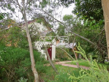
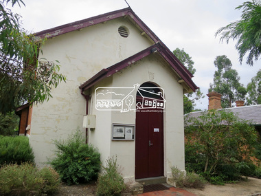
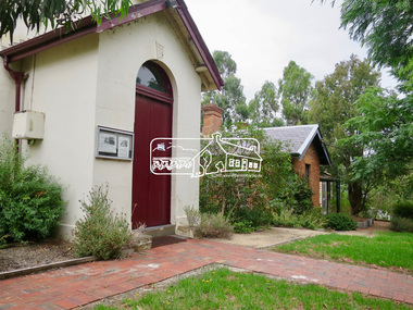
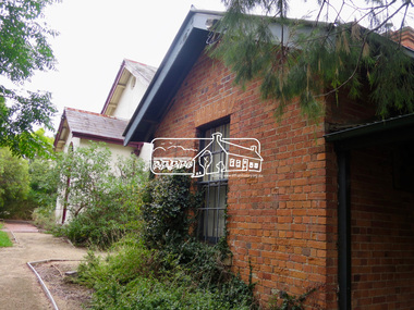
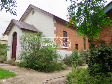
Eltham Gateway, Eltham Justice Precinct featuring the former Eltham Courthouse (1860) at 730 Main Road, the oldest public building in the shire and the former Police Residence (1859) at 728 Main Road, Eltham - now part of the Local History Centre and home to Eltham District Historical SocietyTomorrow's history documented todayeltham, jim connor collection, main road, eltham gateway, eltham courthouse, eltham justice precinct, local history centre, police residence, avenue of honour -
 Eltham District Historical Society Inc
Photograph, Jim Connor, Avenue of Honour, Main Road, Eltham, 14 Jan 2017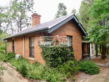
Eltham Gateway, Eltham Justice Precinct featuring the former Eltham Courthouse (1860) at 730 Main Road, the oldest public building in the shire and the former Police Residence (1859) at 728 Main Road, Eltham - now part of the Local History Centre and home to Eltham District Historical SocietyTomorrow's history documented todayeltham, jim connor collection, main road, eltham gateway, eltham courthouse, eltham justice precinct, local history centre, police residence, avenue of honour -
![Photograph - Digital Image, Annie May Medhurst [as infant], 1885_](/media/collectors/4f729f5697f83e03086015b8/items/54d702502162f11a7cfc094c/item-media/54d702842162f11a7cfc0c04/item-fit-380x285.jpg) Greensborough Historical Society
Greensborough Historical SocietyPhotograph - Digital Image, Annie May Medhurst [as infant], 1885_
Photograph of Annie May Medhurst as infant. Born 1884, Annie was the daughter of David Medhurst (1855-1939) and wife Martha Ruston Medhurst (1860-1943) who moved to Greensborough around 1898 and ran a store in Grimshaw Street. Annie May later married William Partington in 1905.Digital copy of black and white studio photograph.aniie may medhurst, annie may partington -
 Eltham District Historical Society Inc
Photograph postcard, River Plenty Bridge, Greensborough
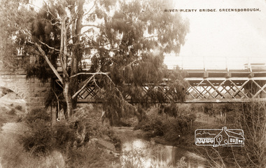
Postcard with view of bluestone bridge over the Plenty River on what is now Main Street, Greensborough. Built in 1860 by a Scottish stonemason, James Neave McKenzie. Most of the bridge was demolished in 1966 with the remaining bluestone arch preserved till 1983 when it was also demolished. This view about 1900.Digital file only Postcards scanned from the collection of Michael Aitken on loan to EDHS, 13 Feb 2018michael aitken collection, postcards, greensborough, plenty river bridge, plenty river -
 Mont De Lancey
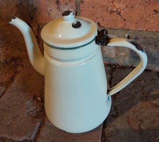
Domestic object - Coffee pot, Reservoir, Unknown
This is a vintage coffee pot. From the 1860's - 1930's various companies called their enamelware products by their own unique names, e.g. graniteware and agateware. The enamel coating put an end to metallic tasting food and prevented rust from contaminating food. It did scratch and chip easily.A tall cream enamel coffee pot with a goose neck spout, handle, green trim around the top and a hinged lid attached with a metal clip.There is Chinese blue script printed onto the base 'Reservoir. Made in China' There is an outline of Chinese electrical towers on the inside .....shaped. '301P - 16 13cm'coffee, coffee pots, kitchenware -
 Bendigo Historical Society Inc.
Book - STRAUCH COLLECTION: WHROO CEMETERY VICTORIA
Although the first recorded burial at Whroo (7 km south of Rushworth) was in 1858, it is believed earlier unrecorded burial took place. The official cemetery was established in 1860 and contains approx. 400 burials although many are unmarked. There is also a Chinese section as in 1863 17% of the population was Chinese in 1863.Red Spring binder containing list of interments in Whroo Cemetery with maps & illustrations.James & Nicola Thomsonplace, cemetery, whroo, victoria-whroo-rusthworth-history-cemetery -
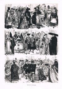 Bendigo Historical Society Inc.
Newspaper - PETER ELLIS COLLECTION: AUSTRALASIAN SKETCHER 1877, 1st September, 1978
Page from the Australasian Sketcher 1 Sept, 1877 with three sketches showing people in various Old time fancy dress. Details are on the back of the page. Also on the back are two other articles: The Bachelors' Quadrille and The Bachelors' Quadrille Assembly. Also a small advertisement for ball boots and shoes available at Abbotts of Pall Mall and a copy of Bachelors' Quadrille Assembly Sixteenth Annual Ball (Bal Masque) held on Tuesday, 4th September, 1888 at the Town Hall, Sandhurst. T. W. Orr, Hon. Sec.newspaper, argus, news items, peter ellis collection, australasian sketcher 1 sept 1877, fancy dress ball, abbott's lyceum theatre, sandhurst town hall, abbotts, t w orr -
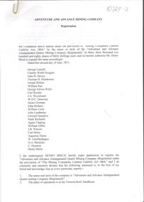 Bendigo Historical Society Inc.
Document - Phyllis Toy Collection: 'Adventure and Advance Mining Company'
This company was registered in May 1871. It amalgamated the Adventure, Advance and Try-me-well mines to mine below the 300 foot levels of these mines.Collection of Government Gazette and newspaper articles relating to the 'Adventure and Advance Amalgamated Quartz Mining Company' on the Victoria Reef, Sandhurst. . Papers include the registration notice of the Mine in 1871, detailing the shareholders. Half yearly meeting reports 1872 - 1880 are attached. Slip of paper attached to each item describes the content, for example 'Half yearly meeting reports of the Adventure and Advance Company as published in the Bendigo Advertiser from 30.1.1872 - 31.8.1880. Missing February 1873, February 1877. Also included, Victoria Consols Company Reports 31.8.1880.adventure gold mine, sandhurst, goldmining, adventure and advance amalgamated quartz mining company -
 Bendigo Historical Society Inc.
Document - MINING WARDEN COLLECTION: BENDIGO HISTORICAL MINING RECORDS
Historical records originally from the Mining Warden's Office, Mines Department, Bendigo. Information collated from 1870's to 1980's. A summary document lists the BEN# from 2585 to 2800 and describes the mine name; the BEN#, the line of reef located on, the start and end year. Mine data is enclosed in a manilla folder within the box. Reef lines listed are: Paddy's Gully Derby Paddy's Gully/Garden Gully Example of entry: Meridien Quartz Mining Co. 2595, Paddy's/Garden Gully, 1876-1877.bendigo, mining, mining warden records -
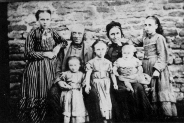 Greensborough Historical Society
Photograph - Digital image, Ruston family, 1865c
Peter Ruston and Martha Roberts had seven children, there are five in this photograph. Anne (1857-83), Martha (1860-1883) between Peter's knees, Sarah (1863-1945), Rachel (1865-1883), Sarah (1865-1957), Mary (1868-1869), Peter (1873-1924) and William (1874-1973).A pioneer Greensborough family.Digital copy of black and white photograph.peter rustin, peter ruston, martha roberts -
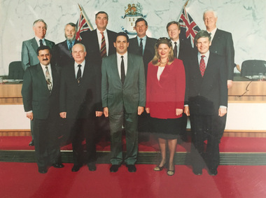 Kew Historical Society Inc
Photograph, City of Kew : 1994 Final Councillors, 1994
Kew was gazetted as a Municipality in 1860, as a Borough in 1863, as a Town in 1910, and as a City in 1921. Under a conservative Victorian Government, led by premier Jeff Kennett, Councils across Victoria were amalgamated, including the City of Kew, which was joined with the Cities of Hawthorn and Camberwell to form a new City of Boroondara (1994- ). This is one of two photographs recording the last Kew Council in 1994. Laminated photograph of City of Kew Final Councillors, taken in 1994, during the year that Council amalgamation led to the demise of the City of Kew. The photograph was laminated a number of years before its donation. CITY OF KEW / 1994 FINAL COUNCILLORS / FROM LEFT: / BACK ROW: ALLEN MARTIN, PHILIP SLOBOM, ROGER STREETON, JAMES TUTT, DARYL OLDAKER, GERARD PETRIE / FRONT ROW: MICHAEL MONTALTO, PAUL VALLIS, TOM INDOVINO (MAYOR), JOAN LAMB, JOHN MURRAYcity of kew councillors, kew council - 1994 -
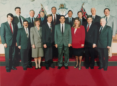 Kew Historical Society Inc
Photograph, City of Kew : 1994 Final Councillors and Corporate Management Group, 1994
Kew was gazetted as a Municipality in 1860, as a Borough in 1863, as a Town in 1910, and as a City in 1921. Under a conservative Victorian Government, led by premier Jeff Kennett, Councils across Victoria were amalgamated, including the City of Kew, which was joined with the Cities of Hawthorn and Camberwell to form a new City of Boroondara (1994- ). This is one of two photographs recording the last Kew Council and senior corporate staff in 1994. Laminated photograph of City of Kew Final Councillors, taken in 1994, during the year that Council amalgamation led to the demise of the City of Kew. The photograph was laminated a number of years before its donation. CITY OF KEW / 1994 FINAL COUNCILLORS AND CORPORATE MANAGEMENT GROUP / FROM LEFT: / BACK ROW: PETER HUGGINS, ALLEN MARTIN, PHILIP SLOBOM, ROGER STREETON, JAMES TUTT, DARYL OLDAKER, GERARD PETRIE, IAN POULTER / FRONT ROW: NEIL HOCKING, MICHAEL MONTALTO, JUNE DUGINA, MALCOLM HUTCHINSON, TOM INDOVINO (MAYOR), JOAN LAMB, JOHN MURRAY, PAUL LAMBcity of kew councillors, kew council - 1994, city of kew corporate staff -
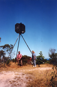 Lakes Entrance Historical Society
Photograph - Lakes Entrance Grid location, 1999
Lakes Entrance Grid reference, Cunninghame 8522.3.4 896.082, on ten acre site with trig point, it is from this point that all the survey for the surrounding areas was undertaken. Part of the Vic Geodetic Survey initiated in 1860 by Ellery Survey started from triangulation base in Werribee. (Grid ref B'dale 8422)Colour photograph of the Victoria Geodetic Survey Triangulation Station, Trig Station, situated off Ocean View Parade, Merrangbaur Hill. Location is indicated by ground point and standing structure, situated on an elevated bush block. Lakes Entrance Victoriasurveying, township planning -
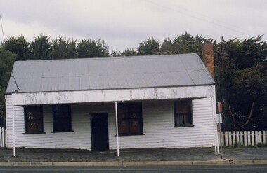 Linton and District Historical Society Inc
Photograph, Former Nicol's Bakery Building, Sussex Street, Linton, 1988
Built early 1860 as a bakery by Mr Winstanley. James Nicol bought the bakery late 1860s - operated as a bakery until 1972, Ray Wilson being the last baker. Max Standish purchased the building and opened an antique shop 1973-1983. Currently in private ownership. Photograph taken in 1988.Colour photograph of white painted single fronted building with pitched roof and verandah over footpath, and trees behind.nicol's bakery, buildings, mr winstanley, james nicol, ray wilson, max standish -
 Warrnambool and District Historical Society Inc.
Document, Sticker Warrnambool Botanic Gardens 150 years A Growing Legacy, 2016
This sticker was issued to celebrate the 150th anniversary of the Warrnambool Botanic Gardens. These Gardens were first established in the early 1850s on a site near the mouth of the Hopkins River but this site proved unsuitable and the Gardens were moved to the present location (Cockman Street/ Botanic Road) in 1866. In 1877 William Guilfoyle was commissioned to provide a plan for the Botanic Gardens . A prominent curator was Charles Scoborio 1872 to 1906. This sticker is a minor interest as a memento of the 150th anniversary in 2016 of the Warrnambool Botanic Gardens A white sheet of paper containing a circular shaped sticker with blue print and a logo in green and purple. The printing is in black and purple.Warrnambool Botanic Gardens 150 years A GROWING LEGACYwarrnambool botanic gardens, william guilfoyle -
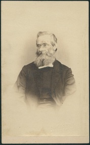 Uniting Church Archives - Synod of Victoria
Photograph, Undated c.1875
Rev. Edward King (1825 - 1905) Wesleyan minister born in England. Entered the ministry in 1846 in England. Came to Australia in 1857. Stationed at: Melbourne East, Brighton, Creswick, Tarnagulla, Castlemaine, Williamstown, Geelong West, Daylesford, Warrnambool, Williamstown, Preston, Drysdale, Colac, Maldon, Beechworth. President of the Victorian Conference of the Methodist Church of Australasia in 1877. Made a supernumerary in 1893. Died at Armadale in 1905.Sepia toned waist length carte de visite studio portrait of the Rev. Edward King."With love from Ed. King" -
 Hume City Civic Collection
Photograph - Our Lady of Mt. Carmel School
The building is Our Lady of Mount Carmel School which is attached to the Catholic Church of the same name. Initially a school was established on this site in 1877 with classes conducted in the church. A new two roomed brick building was erected on the site on 23rd January 1916 and were opened by Archbishop Mannix. There were further additions to the school as enrolments increased in 1925. The school caters for primary school aged students. The school has been functioning in Sunbury for almost 150 years.A coloured of a single storey red brick building with white trims and a red painted iron roofour lady of mount carmel church, our lady of mount carmel primary school -
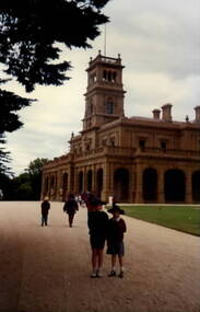 Sunbury Family History and Heritage Society Inc.
Photograph, Werribee Park Mansion, Early 1990s
Brothers homes and Andrew Chirnside, who emigrated from Scotland, built the Italianate -style mansion on their Werribee property between 1874 and 1877. They were pioneering pastoralists who foundered the Chirnside Pastoral Empire. The Victorian Government purchased the property in 1973 and it opened as a tourist attraction in 1977 run by Parks Victoria. The photograph was taken when the students from Bulla Primary School visited the property.The visit to Werribee Park Mansion was included in the students' history studies.A coloured non-digital photograph of a large double storey Italianite style mansion with an imposing lookout tower with flagpole over the main entrance. A large sweeping gravel driveway leads to the main entrance.school excursions, bulla primary schooil, werribee park mansion, thomas chirnside, andrew chirnside, parks victoria -
 Stawell Historical Society Inc
Photograph, Wakeham Street and Seaby Street Stawell formerly the Provincial Hotel 1997
Street Scene - Wakeham Street and Seaby Street (Provincial Hotel) 1997 Provincial Hotel built in 1877 by Mr. Allingham who leased it to Mr. J. Reading. The licensee being held by T.S. Cranston. An advert in 1878 stated 20 good rooms beside out rooms, competent to bed from 40 to 50 persons. Also Billiard and commercial rooms. De licensed in 1916. Weatherboard and Brick building on corner of Seaby & Wakeham Streetstawell, hotel -
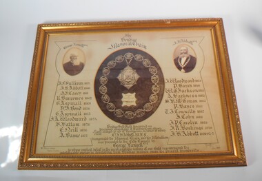 Bendigo Historical Society Inc.
Memorabilia - FRAMED IMAGE OF BENDIGO MAYORAL CHAIN
Large framed item. At the centre a photograph of the Bendigo Mayoral Chain designed and manufactured by F. Prescott, jeweller, Bendigo At the right a photo of George Lansell esq. and on the left a photo of J.H. Abbott esq. A list of Mayor is underneath the two photos, starting from the left J.F. Sullivan 1857, J.H. Abbott 1860, J.J. Casey 1861, R. Burrows 1862, G. Aspinall 1869, J. Boyd 1870, G. Aspinall 1873, J.A. Woodward 1874, H.Hattam 1876, E. Neil 1876, A. Bayne 1877, J.A. Woodward 1879, P. Hayes 1880, W.G. Jackson 1881, A. Harkness 1882, S.H. McGowan 1885, P. Hayes 1886, T.J. Connelly 1887, J. Cohn 1888, J.P. Carolin 1889, J,R. Hoskins 1890, J.H. Abbott 1891-92-95. Under the Mayoral chain the words: Bendigo gold fields discovered 1851. Proclaimed municipality of Sandhurst 1855 and city in 1871. Name changed to City of Bendigo in honor of which event cnr. J.H Abbott inaugurated the mayoral chain and the medallion was presented to the City Council by George Lansell esq. To whose implicit belief in the inextinguishable nature of our gold resource and the indefatigable energy in developing them Bendigo manly owes its present prosperity. July 1893, W. Honeybone Town Clerk and signed by F. Prescott.bendigo, council, mayoral chain, from dudley house stored at bendigo art gallery from 2000, returned to bhs 03/02/2023 -
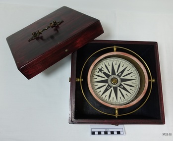 Flagstaff Hill Maritime Museum and Village
Functional object - Compass, mid-19th Century
Captain Robilliard: James Arthur Robilliard was a sea captain and tentmaker, born on the 19th April 1843 at Saint Helier, Jersey. He trained there in his father's sail loft as a sailmaker. His first job as a sailor was in Liverpool, England and 1875 James Robilliard migrated to Australia as mate on the "E.M. Young". James Robilliard and his family were amongst the early settlers that arrived along the Curdies River in the Heytesbury district of Western Victoria. In 1877 he became a Captain and would have used his compass from ship to ship. On 28th May 1877 in that same district a small 3-masted, schooner the "Young Australian" was wrecked. This schooner had been built 1864 at Jervis Bay, NSW. She had been on her way from Maryborough Queensland to Adelaide, under the command of Captain Whitfield, when she lost her mainmast in a heavy gale. She was beached at Curdies Inlet in Peterborough, Victoria, Captain Robilliard was placed in charge of the salvaging operation and recovered a good portion of the cargo. Not long after this incident a Warrnambool shop owner David Evans found employment for James Robilliard with Evan Evans, who produced tents, sails, tarpaulins and similar goods; James already had the necessary skills for this work. Evan Evans was the same sailor rescued from the “Young Australian” soon after his rescue Evan recalled he had a relative in Australia in a town called Warrnambool and while walking in Timor Street, Warrnambool, he saw a sign over a shop that said “David Evans” and once the two men met, Evan was warmly welcomed. David then helped his relative to establish a tent and tarpaulin-making business there. Evan later transferred his successful business to a shop in Elizabeth St, Melbourne, under the name Evan Evans Pty. Ltd.) James Robilliard, a committed Christian, and accredited Lay Preacher with the Methodist Church. He travelled around the local district leading the settlers in worship. On 14th November 1879, Captain Robilliard married Helen Beckett. Alfred and Selina Beckett and their family all attended the church at Brucknell where Captain Robilliard preached. He was said to have been taken by their young daughter Helen. James and Helen had ten children; James Arthur (Jnr), Henry William, Nellie Jessie, Alfred Albert, Rubena Nellie, De Jersy Norman, Clifford Beckett, Olive Ida, Frances Ridley Havergal and Nellie Elvie, all born in Victoria. In the 1880s James Robilliard captained the cutter "Hannah Thompson" into Port Campbell, Victoria. This vessel was the first coastal trader to operate between Melbourne and Port Campbell. At one time Captain Robilliard had to beach the "Hannah Thompson" for repairs. In 1923 she was blown ashore in a gale and wrecked at Oberon Bay, at Wilson's Promontory. In 1889 the compass was saved by Captain James Arthur Robilliard from his sinking brigantine "Mary Campbell" in 1889. This vessel was used to carry equipment for the Sydney Sugar Refinery's Mill in Southgate, NSW. The ship had been built in 1869 and traded for the next 20 years between Australian ports and rivers along the east coast as well as regular ports in New Zealand. She was recognised by the Sydney Morning Herald as one of the best "carrying vessel in the timber trade". She had several owners over this time, the last one being Captain James A. Robilliard. On 29th April 1889 the "Mary Campbell", with Captain James A Robilliard as captain and owner, was on her way from Clarence River, NSW to Melbourne, Victoria with a cargo of railway girders for the Melbourne Harbour Trust. Captain Robilliard encountered a storm off Port Macquarie. He sailed the vessel south to about 40km east of Cape Hawke, near Tuncurry. At around 7 pm, he discovered that the cargo had shifted during the storm and the heavy girders had damaged the hull, causing a leak. The pumps were inadequate to stem the fast-flowing leak water soon filled the hull during the next two hours. Some of the crew began throwing the cargo overboard to lighten the vessel, hoping to keep it afloat until daylight. When the water reached over 2 meters in the hull they realised their efforts were in vain. On the 30th April 1889, the crew left the vessel the ship was sinking fast, so they made for the shore. While still miles off Cape Hawke all seven crew members, including the Captain, were rescued by the Government Tug "Rhea" and taken to Port Macquarie Hospital and later returned to Sydney in the vessel "Wellington". No cargo had been saved and the consignment had been under-insured, only covered for half its value. The name of the last ship Captain Robilliard sailed is currently unknown, however, he sailed that ship from the port of Marlborough, Queensland, carting steel railway girders for the Geelong-to-Camperdown railway line. On this trip the ship hit a storm, the cargo shifted and the ship was wrecked along the NSW coast. After this, Captain Robilliard retired from the sea and began farming in Peterborough. In about 1897, verging on retirement, Capt. Robilliard superintended the Melbourne Sailors’ Home in Spencer Street, Melbourne, before being asked to leave this position in 1902 for trying to shut down a local hotel. On 6th May 1917 Captain James Arthur Robilliard J.P. died at Blackwood Park, in the Cobden district of Brucknell, the first Robilliard family homestead in Australia. He was buried in the Melbourne General Cemetery, Victoria. His wife Helen passed away in 1947. This compass, once belonging to Captain James Arthur Robilliard, is of local and state historical significance for its use by the Captain with his vessel the "Mary Campbell", a trading vessel that was bringing railway girders to the Melbourne Harbour Trust. He also used this compass on the "Hannah Thompson", listed on the Victorian Heritage Register and known as being the first coastal trader to operate between Melbourne and Port Campbell. The compass is also a very fine example of maritime navigational instruments manufactured and used in the mid-19th century. Marine compass, brass, in wooden box with separate, fitted lid. The compass card has sixteen points. The four principal points are marked; North with a star shaped, South with an “S”, East with and “E” and West with an “O” (French word OUEST). Each quadrant of the circle is numbered from 0 – 90 degrees. The card is floating in a liquid. The compass gimbal is attached to the sides of the box and to the front and back of the compass’ cylindrical brass frame. The mahogany coloured timber storage box is joined with brass nails. The centre of the lid has a folding decorative brass handle. The lid fits over base and closes with a brass screw and hook on both front and back. Maker; Dubas Watchmaker Optician, Nantes, France, c 1860-1870. Compass came from the ship “Mary Campbell”, which sank off the NSW coast in 1889, near Forster. The compass, as well as the ship, belonged to Captain James Arthur Robilliard and was donated by his family. “DUBAS MANTES” stamped into side of gimbal. “DUBAS HORLOGER OPTICIEN. NANTES.” printed around centre of card. flagstaff hill, warrnambool, shipwrecked coast, flagstaff hill maritime museum, maritime museum, shipwreck coast, flagstaff hill maritime village, great ocean road, marine compass, navigation instrument 19th century, marine instruments, dubas mantes, captain james arthur robilliard, j.a. robilliard, helen beckett, ship young australian, ship young australia(n), ship hannah thompson, ship mary campbell, melbourne sailors home, david evans, evan evans, curdies inlet, brucknell church, curdies railway, great lakes museum -
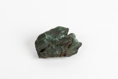 The Beechworth Burke Museum
Geological specimen - Malachite, Unknown
This specimen is a copper-carbonate malachite mineral. It is often found as crystalline aggregates or crusts, which have a banded agate-like appearance while also commonly found as botryoidal clusters of radiating crystals. Malachite is often bright green in colour, with dark green and blackish blooms or stripes/bands throughout the mineral. This particular specimen was recovered from the Burra Burra Copper Mine located Burra, South Australia. By the 1860's, South Australia was known as the "Copper Kingdom" due to its large amount of copper mines and huge success in the copper mining industry. Burra Burra was no exception to this phenomena, as this mining company was greatly famous and successful, being nicknamed the "Monster Mine". It was first established in 1848 and was the largest metal mine in Australia up until 1860. This specimen is significant as it highlights the historic use and value of malachite and the rarity of the mineral. Malachite is a rare gemstone which has been used in various ways historically. It has been cut and sculpted into beads for jewellery use as its rich colour and distinct yet unique patterns have made it a well sought after gemstone. Its' continued use over time only heightens the value and significance of this mineral.A hand-sized solid copper-carbonate hydroxide mineral specimen in shades of blue, green and copper tones throughout.MALACHITE / (Copper carbonite) / Locality: Burra, South Aust. | Malachite / Burra Burra / South Australia / (good specimen) / needs a wash / BBburke museum, burke museum collection, beechworth museum, beechworth, geological specimen, geological, mineral, mineraology, copper carbonate, malachite, burra burra mine, copper mining -
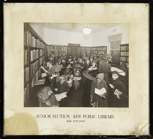 Kew Historical Society Inc
Photograph, C Stuart Tompkins, Junior Section, Kew Public Library, 15 May 1945
1860: Kew's first library was the Kew Literary and Scientific Society, which opened on 6 August 1860. 1884: Kew Town Hall was extended and the library transferred to a room on the upper floor. This was not an ideal arrangement as the room was required for Council purposes. 1904: A cottage adjoining Kew Town Hall was purchased for use as a library. 1937: The library was closed for a major overhaul of stock and renovation of the building. It reopened in December 1937 and remained there for more than 35 years. 1973: When the Civic Centre opened in Charles Street, Kew, the library moved in. 1987: Kew Library moved to its current location in the converted city hall, overlooking the beautiful Alexandra Gardens. The library was officially opened at this site on Friday 23 October 1987 by the Mayor of Kew, Cr James Tutt. (Source: Boroondara Library Service)Early original photograph of a children's library service taken by a notable Melbourne photographerOriginal photograph, in original frame, of the Junior Section of the Kew Public Library in Walpole Street, Kew. The photograph was taken by Stuart Tompkins who was the photographer of choice by the City of Kew from the 1930s to the 1960s. The details of the photograph are inscribed on the water-damaged mount, with the photographers signature at lower right. . "Junior Section, Kew Public Library, May 15th 1945"kew public library, photographers - c. stuart tompkins - camberwell (vic), children's libraries -
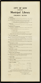 Kew Historical Society Inc
Document, City of Kew, City of Kew Municipal Library, Children's Section, 1953
1860: Kew's first library was the Kew Literary and Scientific Society, which opened on 6 August 1860. 1884: Kew Town Hall was extended and the library transferred to a room on the upper floor. This was not an ideal arrangement as the room was required for Council purposes. 1904: A cottage adjoining Kew Town Hall was purchased for use as a library. 1937: The library was closed for a major overhaul of stock and renovation of the building. It reopened in December 1937 and remained there for more than 35 years. 1973: When the Civic Centre opened in Charles Street, Kew, the library moved in. 1987: Kew Library moved to its current location in the converted city hall, overlooking the beautiful Alexandra Gardens. The library was officially opened at this site on Friday 23 October 1987 by the Mayor of Kew, Cr James Tutt. (Source: Boroondara Library Services)Historically and socially significant set of regulations governing the use of the children's library in Kew in the early 1950sOriginal framed rules and regulations of the junior section of the Kew Library, dated 16.6.1953, authorised by the Mayor (W.E.R. Hope) and Town Clerk (W.D.Birrell). The document also lists opening hours of the Kew and East Kew branches.kew public library - kew (vic), kew public library - east kew (vic), city of kew - library guidelines -
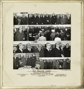 Kew Historical Society Inc
Photograph, Stuart Tompkins Studios, Kew Municipal Library: Opening of Extentions by The Hon. L.W. Balvin M.L.A. Chief Secretary, 19 October 1954
Kew Library history: 1860: Kew's first library was the Kew Literary and Scientific Society, which opened on 6 August 1860. 1884: Kew Town Hall was extended and the library transferred to a room on the upper floor. This was not an ideal arrangement as the room was required for Council purposes. 1904: A cottage adjoining Kew Town Hall was purchased for use as a library. 1937: The library was closed for a major overhaul of stock and renovation of the building. It reopened in December 1937 and remained there for more than 35 years. 1973: When the Civic Centre opened in Charles Street, Kew, the library moved in. 1987: Kew Library moved to its current location in the converted city hall, overlooking the beautiful Alexandra Gardens. The library was officially opened at this site on Friday 23 October 1987 by the Mayor of Kew, Cr James Tutt.An historically interesting photographic record of investment in public infrastructure and services by municipal councils during the 1950s. Framed photographic collage showing the opening of Extensions to the Kew Municipal Library by The Hon. L.W. Balvin M.L.A. Chief Secretary on 19 August 1954. The photos are in their original mount and frame.[Inscription] "Kew Municipal Library: Opening of Extentions by The Hon. L.W. Balvin M.L.A. Chief Secretary 19.8.1954, with Cr. A.S.C. Stevens J.P. Mayor and Cr. W.D. Vaughan J.P. Chairman Library Council". [Photographer] "Stuart Tompkins Studios."kew library, cr a.s.c. stevens, cr w.d. vaughan, australian photographers - stuart tompkins studio -
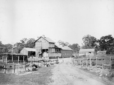 Stawell Historical Society Inc
Photograph, Fountain Head Brewery at Armstrong 1866
Fountain Head Brewery Armstrong's. Part of a collection of Photographs by Mr. O.G. Armstrong as commissioned by the Shire of Stawell for the Inter-colonial and Paris Exhibition in Melbourne in 1866. The brewery, a three-storey high building, was established close to two streams which joined the Concongella Creek near Armstrong, although the water required to run the brewery was obtained from a natural underground spring which is still visible. Further findings of Gold in Victoria around 1859-1860 brought a large rush of miners to the area. Some stayed on to become merchants, farmers, etc. Jens Kofoed, a shipwright from the Netherlands, was one who came to the area at this time. He and his family move to Armstrong in 1860, establishing the Fountain Head Brewery, which employed quite a number of people for about 40 years. stawell industry