Showing 4723 items matching "1878-1890"
-
 Bendigo Historical Society Inc.
Clothing - SKIRT (WEDDING DRESS), 1896
Probably 1890's to early 1900's. The Dress and Mantle Makers departments was part of F. Davey and Co. and the department was run by Miss Middleton, formerly of the Beehive. F Davey and Co. sold their View Point premises in Oct 1904.Cream coloured silk wedding dress with train. Three flat panels at front and side, lined with polished cotton. Centre tightly gathered panel at centre back lined with stiffened cotton.Other panels lined with stiffened cotton above hemline of skirt. Double layer lace insert inside lower edge to hemline. Back opening with four hook and eye fasteners. Deep pocket on side seam at hip on RHS. Three back panels extended below hemline of skirt to form squared edge train. Two hanging tapes inside waist band. Skirt hand and machine stitched. Matching bodice 11400.314.Label stitched inside skirt waistband - ''F.Davey & Co Dress & Mantle makers, View Point, Sandhurst.costume, female, wedding dress skirt -
 Learmonth and District Historical Society Inc.
Photo - Spiers, Richards & Co. Photos, Ballaarat, Councilor John Pollock Spiers. 1883-84, "circa 1884"
Councilor John Pollock Spiers was elected to council in 1878 until 1880,1880 until 1892,1893 until 1902,1904 until 1910 and 1915 until 1918.He served two terms as President,1889-90 and 1899-1900.Councilor Spiers was a resident of Learmonth.Part of original collection of photos showing all councilors for 1883-84. This photo of Councilor John Pollock Spiers is in sepia tones and oval in shape,set in a "light tan"mount with gold edging around the cut out.Surounding the photo is a fine line and decorative features which link it to the next photo. It is on the right side second from bottom of the circle of photos showing all councilors for 1883-84. PRESENTED by the PRESIDENT J.DALGLIESH ESQ. to the BALLAARAT SHIRE COUNCIL 1883-84.ballarat shire council, john pollock spiers 1883 84 -
 St Kilda Historical Society
Ephemera - Ticket - concert, Christian Brothers' College St Kilda Annual Concert, 1918
Christian Brothers College, St Kilda, was established in 1878 as a private secondary college for boys. Since 2021, following the closure of its sister school for girls, Presentation College Windsor, it has operated as a co-educational school called St Mary's College.Pale blue square card with black printing on one sidePrinted on face: Christian Brothers' College, St. Kilda, ANNUAL CONCERT, St Kilda Town Hall, Tuesday, Dec. 17, 1918. Proceeds in aid of Christian Brothers' Training College Jubilee Fund. His Grace the Most Rev. Dr. Mannix will Preside. Row J 81 ADMIT ONE This part to be given up at the Door.st kilda town hall, st kilda schools, christian brothers college, christian brothers training college, 1918, 20th century, dr mannix, christian brothers -
 Eltham District Historical Society Inc
Photograph, Jock Ryan speaking on Gold and Charles Mapleston, 2001 Conference of the Association of Eastern Historical Societies hosted by Eltham District Historical Society, Eltham Senior Citizen's Hall, 28 April 2001
Jock Ryan of Nillumbik Historical Society, Diamond Creek spoke about Charles Maplestone (1809-1878) who was an architect and designed St John's Anglican Church, Diamond Creek. In the background of the photo is an information banner headed: "Centenary of Federation 1901-2001".Colour photographsenior citizen's hall, association of eastern historical societies conference, activities, jock ryan, centenary of federation -
 Bendigo Historical Society Inc.
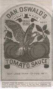
Newspaper - JENNY FOLEY COLLECTION: STRAIGHT FROM THE SOURCE
Daniel Oswald (1876-1947) married Louisa Trgonning (1878-1955) in 1902. They had the following family:- Lorna (1904-1920); David Sinclair (1905-1988); John Reginald (1909-1973); Daniel Dallas (1910-1966) and Dugdale (1919-1980)Bendigo Advertiser '' The way we were'' from 2002. Straight from the source: Daniel Oswald once manufactured tomato sauce at Oswald's Cordial Factory, in Peg Leg Road Eaglehawk. The business was later taken on by his son Reg and sauce continued to be made there until the late 1950s. The clip is in a folder.newspaper, bendigo advertiser, the way we were -
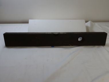
 Flagstaff Hill Maritime Museum and Village
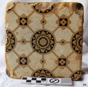
Ceramic - Tile, circa 1878
This Minton floor tile is from the wreck of the LOCH ARD. Other examples of this manufacture have been recovered from the wreck site and form part of the collection at Flagstaff Hill. The iron-hulled clipper ship from the Loch Line was heading for Port Phillip from London when it ran into the cliffs of Mutton Bird Island near Port Campbell and was wrecked on the early morning of June 1, 1878. The LOCH ARD was laden with high-value cargo including luxury goods intended for display at the Melbourne International Exhibition in 1880. One notable survivor from the ship’s freight manifest was the well-packed Minton porcelain peacock, a two-metre-high ceramic masterpiece of vivid glazed colours. The almost total loss of life and property from the LOCH ARD registered as a shocking tragedy for the Colony of Victoria, at a time when social confidence and economic optimism were otherwise high. The wealth generated from gold and wool was increasingly being spent on magnificent private residences and imposing public buildings. The demand for quality furnishings and fittings was therefore strong. Among the products consigned to burgeoning colonial markets by the Milton Pottery at Stoke upon Trent were their new range of colourfully patterned but very durable floor tiles – ideal for the high-traffic spaces in the large civic buildings then being constructed in Australia and America. These new floor tiles were “encaustic”, meaning that their designs and colours were encased within the depth of the tile. Rather than their decorative patterns being glazed onto the surface of the tile, their inlaid designs were created during the manufacturing process, as “coloured slips” (or liquid clay) that were poured into a deep pre-moulded casting. When fired, the resulting tile was colour-fast and design-fast.The Minton encaustic floor tile is significant for its method of manufacture which makes it durable as well as decorative. The shipwreck of the LOCH ARD is of State significance. Victorian Heritage Register S417. Flagstaff Hill’s collection of artefacts from LOCH ARD is significant for being one of the largest collections of artefacts from this shipwreck in Victoria. It is significant for its association with the shipwreck, which is on the Victorian Heritage Register (VHR S417). The collection is significant because of the relationship between the objects, as together they have a high potential to interpret the story of the LOCH ARD. The LOCH ARD collection is archaeologically significant as the remains of a large international passenger and cargo ship. The LOCH ARD collection is historically significant for representing aspects of Victoria’s shipping history and its potential to interpret sub-theme 1.5 of Victoria’s Framework of Historical Themes (living with natural processes). The collection is also historically significant for its association with the LOCH ARD, which was one of the worst and best-known shipwrecks in Victoria’s history.A square Minton floor tile with a black and beige pattern against a white base. This encaustic floor tile was recovered from the shipwreck of the LOCH ARD. On the back, or base, of the tile is inscribed the number “46” and the letters “Minton & Co Patent Stoke upon Trent”.flagstaff hill, warrnambool, shipwrecked coast, flagstaff hill maritime museum, maritime museum, shipwreck coast, flagstaff hill maritime village, great ocean road, loch line, loch ard, mutton bird island, loch ard gorge, minton floor tile, encaustic tile, melbourne international exhibition, floor tile -
 Flagstaff Hill Maritime Museum and Village
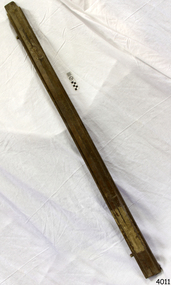
Tool - Wood Sample, Before 1878
On a piece of paper subsequently glued near one end of its curved upper face, this length of planed and polished hardwood timber bears the inscription: “A [p]iece of w[r]ec[k] of the Loch Ard wrecked near Sherbroke River”. The timber is carefully worked with rich dark colouring and a uniformly moulded design, suggesting that it was part of a fitting or furnishing that was publicly visible and prominent. If the artefact is what it is declared to be, then it is possible that it formed part of the ship’s railings or companionway stairs. The LOCH ARD was a 1,693 ton, 3 masted barque, built on the Clyde in 1873. In an age of increasing competition for the emigrant passenger trade from steam-driven vessels, special attention was paid to her wooden furnishings and fittings. The Loch Line owners prided themselves on their attractive, distinctively painted, sailing ships. Below decks, where cargo and third class passengers were stowed, was made of iron. But everything above deck, and on show to the saloon and second class passengers, was carved and varnished timber. Captain Daish’s 1878 report for the ship’s underwriters notes “a quantity of general Cargo washed up in a confused mass” in the cove and “a number of Cases, Casks and Bales; also deals and boards floating about in some of the gorges” further west of the shipwreck. Contemporary newspaper accounts also reported a large quantity of cargo and timber washed ashore in the days following the LOCH ARD shipwreck, adding “but those were speedily removed by persons who came down from Port Campbell, Scott’s Creek and other places with carts and pack horses”. The appearance and good condition of this wood artefact, and the aged patina and dated hand-writing style of its pasted on inscription, support the suggestion that it was ‘souvenired’ from the floating debris of the LOCH ARD at or near the 1878 date of its foundering off Mutton Bird Island. HISTORY OF THE LOCH ARD The LOCH ARD belonged to the famous Loch Line which sailed many ships from England to Australia. Built in Glasgow by Barclay, Curdle and Co. in 1873, the LOCH ARD was a three-masted square rigged iron sailing ship. The ship measured 262ft 7" (79.87m) in length, 38ft (11.58m) in width, 23ft (7m) in depth and had a gross tonnage of 1693 tons. The LOCH ARD's main mast measured a massive 150ft (45.7m) in height. LOCH ARD made three trips to Australia and one trip to Calcutta before its final voyage. LOCH ARD left England on March 2, 1878, under the command of Captain Gibbs, a newly married, 29 year old. She was bound for Melbourne with a crew of 37, plus 17 passengers and a load of cargo. The general cargo reflected the affluence of Melbourne at the time. On board were straw hats, umbrella, perfumes, clay pipes, pianos, clocks, confectionary, linen and candles, as well as a heavier load of railway irons, cement, lead and copper. There were items included that intended for display in the Melbourne International Exhibition in 1880. The voyage to Port Phillip was long but uneventful. At 3am on June 1, 1878, Captain Gibbs was expecting to see land and the passengers were becoming excited as they prepared to view their new homeland in the early morning. But LOCH ARD was running into a fog which greatly reduced visibility. Captain Gibbs was becoming anxious as there was no sign of land or the Cape Otway lighthouse. At 4am the fog lifted. A man aloft announced that he could see breakers. The sheer cliffs of Victoria's west coast came into view, and Captain Gibbs realised that the ship was much closer to them than expected. He ordered as much sail to be set as time would permit and then attempted to steer the vessel out to sea. On coming head on into the wind, the ship lost momentum, the sails fell limp and LOCH ARD's bow swung back. Gibbs then ordered the anchors to be released in an attempt to hold its position. The anchors sank some 50 fathoms - but did not hold. By this time LOCH ARD was among the breakers and the tall cliffs of Mutton Bird Island rose behind the ship. Just half a mile from the coast, the ship's bow was suddenly pulled around by the anchor. The captain tried to tack out to sea, but the ship struck a reef at the base of Mutton Bird Island, near Port Campbell. Waves broke over the ship and the top deck was loosened from the hull. The masts and rigging came crashing down knocking passengers and crew overboard. When a lifeboat was finally launched, it crashed into the side of LOCH ARD and capsized. Tom Pearce, who had launched the boat, managed to cling to its overturned hull and shelter beneath it. He drifted out to sea and then on the flood tide came into what is now known as LOCH ARD Gorge. He swam to shore, bruised and dazed, and found a cave in which to shelter. Some of the crew stayed below deck to shelter from the falling rigging but drowned when the ship slipped off the reef into deeper water. Eva Carmichael had raced onto deck to find out what was happening only to be confronted by towering cliffs looming above the stricken ship. In all the chaos, Captain Gibbs grabbed Eva and said, "If you are saved Eva, let my dear wife know that I died like a sailor". That was the last Eva Carmichael saw of the captain. She was swept off the ship by a huge wave. Eva saw Tom Pearce on a small rocky beach and yelled to attract his attention. He dived in and swam to the exhausted woman and dragged her to shore. He took her to the cave and broke open case of brandy which had washed up on the beach. He opened a bottle to revive the unconscious woman. A few hours later Tom scaled a cliff in search of help. He followed hoof prints and came by chance upon two men from nearby Glenample Station three and a half miles away. In a state of exhaustion, he told the men of the tragedy. Tom returned to the gorge while the two men rode back to the station to get help. By the time they reached LOCH ARD Gorge, it was cold and dark. The two shipwreck survivors were taken to Glenample Station to recover. Eva stayed at the station for six weeks before returning to Ireland, this time by steamship. In Melbourne, Tom Pearce received a hero's welcome. He was presented with the first gold medal of the Royal Humane Society of Victoria and a £1000 cheque from the Victorian Government. Concerts were performed to honour the young man's bravery and to raise money for those who lost family in the LOCH ARD disaster. Of the 54 crew members and passengers on board, only two survived: the apprentice, Tom Pearce and the young woman passenger, Eva Carmichael, who lost all of her family in the tragedy. Ten days after the LOCH ARD tragedy, salvage rights to the wreck were sold at auction for £2,120. Cargo valued at £3,000 was salvaged and placed on the beach, but most washed back into the sea when another storm developed. The wreck of LOCH ARD still lies at the base of Mutton Bird Island. Much of the cargo has now been salvaged and some was washed up into what is now known as LOCH ARD Gorge. Cargo and artefacts have also been illegally salvaged over many years before protective legislation was introduced. One of the most unlikely pieces of cargo to have survived the shipwreck was a Minton porcelain peacock - one of only nine in the world. The peacock was destined for the Melbourne International Exhibition in 1880. It had been well packed, which gave it adequate protection during the violent storm. Today, the Minton peacock can be seen at the Flagstaff Hill Maritime Museum in Warrnambool. From Australia's most dramatic shipwreck it has now become Australia's most valuable shipwreck artefact and is one of very few 'objects' on the Victorian State Heritage Register. The Loch Ard wreck is of state significance – Victorian Heritage Register S417. However there is a lack of documented provenance that limits the interpretive value of this piece of timber (for example, its potential to interpret nineteenth century souveniring and scavenging from shipwrecks along the south west coast of Victoria). Flagstaff Hill’s collection of artefacts from LOCH ARD is significant for being one of the largest collections of artefacts from this shipwreck in Victoria. It is significant for its association with the shipwreck, which is on the Victorian Heritage Register (VHR S417). The collection is significant because of the relationship between the objects, as together they have a high potential to interpret the story of the LOCH ARD. The LOCH ARD collection is archaeologically significant as the remains of a large international passenger and cargo ship. The LOCH ARD collection is historically significant for representing aspects of Victoria’s shipping history and its potential to interpret sub-theme 1.5 of Victoria’s Framework of Historical Themes (living with natural processes). The collection is also historically significant for its association with the LOCH ARD, which was one of the worst and best known shipwrecks in Victoria’s history. A length of hardwood timber, planed and varnished to smooth finish on three sides, with two unfinished tongues protruding from each end (one broken off), possibly from the wreck of the LOCH ARD. The front or upper face is moulded and routed to a regular, linear (skirting board type) design along its entire length, the two sides flat planed. One side contains two inserted dowel rods that have been broken off. The bottom face has not been finished to the same standard. The sample is good quality wood that has retained its density and weight and shows no evidence of having been submerged in seawater for any length of time. Glued on to the upper face of the length of timber near the right hand end is a deteriorated square of paper bearing an inscription. The paper, peeling back and with torn edges, is stuck over an original wood stain but under a subsequent layer of varnish. The faded ink words are indecipherable where paper is missing, but written carefully in an old fashioned cursive script.The inscription on the paper reads: “A [p]iece of w[r]ec[k] of the Loch Ard wrecked near Sherbroke River”. flagstaff hill, warrnambool, shipwrecked coast, flagstaff hill maritime museum, maritime museum, shipwreck coast, flagstaff hill maritime village, great ocean road, loch line, loch ard, captain gibbs, eva carmichael, tom pearce, glenample station, mutton bird island, loch ard gorge, nineteenth-century souveniring, shipwreck scavenging, loch line sailing ships, wood sample -
 Bendigo Historical Society Inc.
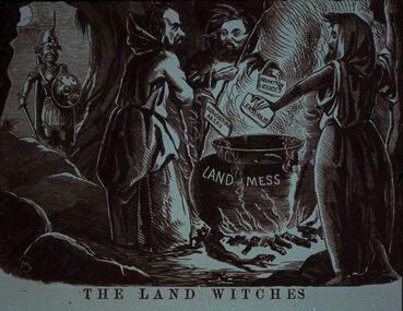
Slide - DIGGERS & MINING. LIFE OF THE SELECTORS, c1860
Diggers & Mining. Life Of The Selectors. Diggers & Mining. A soldier looks on as three male witches stand around a cauldron placing cards in the pot with OCCUPATION LICENSES, LEASE HOLDS and AGRICULTURAL AREAS written on them, the cauldron is labelled LAND MESS. The title of the picture is 'The Land Witches'. Markings; Life Of The Selectors 1860-1890 Set 432 No. 16. The Land Witches ''Melbourne Punch,'' Feb 25, 1864. Used as a teaching aid.Visual Eduation Centreeducation, tertiary, goldfields -
 Bendigo Historical Society Inc.
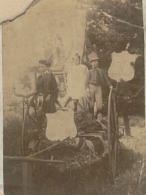
Photograph - EASTER FAIR, JUVENILE FIRE BRIGADE, c1890's
Sepia photograph of group of children. Two girls, two boys on hand card. Four shields and banner decoration. Lion statue on right front. One boy in Scottish dress. One with top hat with feather. Girls with coronets. On back - 'Easter Procession Exhibit, 1890's +, probably Juvenile Fire Brigade' . On back - 3cls, p8, A feast', 'Royal Historical Society of Victoria, Bendigo Branch' circular stamp.person, group, easter procession -
 Bendigo Historical Society Inc.
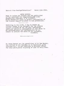
Document - ANTON MEURER
Typed extract from The Bendigo Advertiser dated March 13th 1890. Article mentions Anton Meurer has purchased the ironmongery business of Mr W Conway. Also a short note from W. Conway thanking his customers for their support and his confidence in the new owner satisfying the wants of his customers. Mr Anton Meurer was the grandfather of Mr Ron Meurer who had an electrical goods store.document, names of bendigo pioneers, bendigo advertiser, anton meurer, bendigo advertiser 13/3/1890, mr w conway, mr ron meurer, kelly bros. -
 Whitehorse Historical Society Inc.
Document, Nunawading, ?1995
Photocopy of search notes summarising memorials relating to part Crown Portions 80,81,82,89,90 and 91 originally granted to John Woods, 31 March 1855 and transferred to Frederick Walter Purches, Edwin James Purches, George Seth Coppin, Freehold Investment and Banking Co of Australia and Australian Deposit and Mortgage Bank; with page listing titles derived from Freehold Investment and Banking Co of Australia Limited 1889 - 1890.non-fictionmorton thomas richards burrowes -
 Bendigo Historical Society Inc.
Administrative record - Land Leases 1886 - 1899
Dr Ralph Birrell (20/3/1927 - 7/6/2014) was a lecturer at the Bendigo School of mines and the author of numerous books about mining in Victoria, particularly Bendigo, and books on various elements of Bendigo history.Set of handwritten land leases books compiled by Ralph Birrell. Book 17: 5156/5573, year 1886. Book 18: 5574/5891. year 1887. Book 19: 5892/6211, year 1890. Book 20: 6212/6531, year 1893. Book 21: 6532/6849, year 1896. Book 22: 6849/71765, year 1897. Book 23: 7166/7390, year 1899.land leases, 1886-1899 -
 Kiewa Valley Historical Society
Tool - Spirit Level
The Stanley Works was founded by Frederick Trent Stanley in 1843 located in New Britain, Connecticut USA. The Stanley Rule and Level Company was founded by Frederick's cousin Henry Stanley in 1857. Stanley introduced the first steel tape, Stanley introduced utility knives in 1936. Stanely buildt the largest hand tool plant in the world in New Britain, CT (Connecticut). In 1920, the Rule and Level Co. merged with the Stanley Works, which in turn merged with Black and Decker in 2010.Owned by Kiewa valley resident, Lankey Higginson.Solid wooden plank with brass attached by screws. brass plates at each end, around the level 'window' and further along. Also with a 'badge'. This latter one is beside a ound hollow which has a level window to measure the vertical side. The horizontal level measure is in the centre on the narrower ledge of wood. On the centre wider edges is a groove to assist in hold in the spirit level steady. Above the glass levelAbove the glass level, inscribed on a brass plate is "Stanley / Rule and Level Co. / New Britain Conn. U.S.A. / Pat. 6 -2-91 and 6 -28 -96" Also, 2 small brass plaques / badges inscribed: "ADJ pat. Feb. 1890 / screw."stanley rule and level co., spirit level, higginson family -
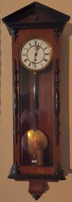 Mont De Lancey
Functional object - Wall Clock, late 1800's
History of Clock Wandin North 8th Jan'y 1952. This clock was bought by the late Henry Sebire of 'Mont de Lancey' Wandin Yallock, at a clearing sale of Mrs Newey's at Seville about the year 1890; After his death in July 1902 the clock was given to his eldest son, one of his Executors, (Henry T. Sebire) of Ivanhoe, who died on 29th November 1935. On 6th February 1945 nearly 10 years later Mrs H. T. Sebire gave the clock to Wandin T. Sebire of Wandin North, who very much appreciated the gift. The clock was called for at Ivanhoe by Len Sebire, on 21st March 1945. Wandin T. Sebire. The clock was oiled and repaired by Mr Upton Watchmaker of Wandin North returned by him on 4th Dec 1951. Oiled again and returned 7th Feb. 1953.A tall narrow pendulum wooden wall clock with a white round clock face, with Roman numerals, elaborate fine hands and a brass pendulum enclosed in a glass faced compartment which has a decorative dark wood at the top. There are small clips at the top and bottom to open the case door. A brass key is stored inside the cabinet.This note was attached to the donation sheet. 'History of Clock Wandin North 8th Jan'y 1952. This clock was bought by the late Henry Sebire of 'Mont de Lancey' Wandin Yallock, at a clearing sale of Mrs Newey's at Seville about the year 1890; After his death in July 1902 the clock was given to his eldest son, one of his Executors, (Henry T. Sebire) of Ivanhoe, who died on 29th November 1935. On 6th February 1945 nearly 10 years later Mrs H. T. This note was attached to the donation sheet. Sebire gave the clock to Wandin T. Sebire of Wandin North, who very much appreciated the gift. The clock was called for at Ivanhoe by Len Sebire, on 21st March 1945. Wandin T. Sebire. The clock was oiled and repaired by Mr Upton Watchmaker of Wandin North returned by him on 4th Dec 1951. Oiled again and returned 7th Feb. 1953.'wall clocks, plaques -
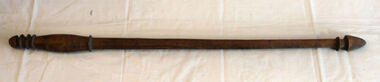 Orbost & District Historical Society
hunting stick
Inspected by Joanna Freslov, archaeologist 2.6.2008. This club was brought from New Hebrides to Orbost by Reverend Alex Morton in 1894. Morton was the minister at the Presbyterian church about 1890. He had spent time in new Hebrides and went on to New Zealand.A handmade carved wooden club with carved rings at top and bottom.weapon new-hebrides hunting-club morton -
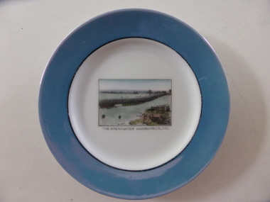 Warrnambool and District Historical Society Inc.
Souvenir plate, The breakwater, Mid 20th century
This item has been bought as a souvenir of Warrnambool probably by a tourist. It features the breakwater built in 1890 to assist shipping in the port of Warrnambool . Tourism is important in Warrnambool today - in Summer the coastal scenery and the beaches and in Winter the with the whale season and the May Racing Carnival This item is of minor interest as an example of a tourist souvenir of Warrnambool.Small circular plate with pale blue border with interior black ring. The centre of the plate is white and has a rectangular image of the breakwater.The breakwater Warrnambool Vic is in black text underneath the image. Noritake made in Japan in green on back of the platewarrnamool breakwater -
 Glenelg Shire Council Cultural Collection
Photograph - Photograph - Portland Gaol, n.d
The Gaol at Portland was in operation as early as 1852. It was reproclaimed in the Government Gazette, along with several other prisons in the colony, in October 1877. In 1892, it was proclaimed a Police Gaol, under the provisions of the Gaols Act 1890. The Police Gaol was closed by proclamation in March 1893.Black and white photo of gaol at Portland, two sides visible. High stone walls, roof of building visible behind walls. Large stone pillars either side of wooden entrance. Dilapidated wooden fence, cow grazing in foreground.Front: 'THE FIRST JAIL IN VICTORIA, PORTLAND' - white print on bottom edge of photoportland gaol, jail, incarceration, prison -
 Kew Historical Society Inc
Map, MMBW, MMBW Town of Kew, 1910-21
The Melbourne and Metropolitan Board of Works (MMBW) was established by an act of the Victorian Parliament in 1890 to prepare for and to implement a sewerage and water reticulation system across what was then inner Melbourne, its surrounding and middle distance suburbs, including Kew. The MMBW was disbanded in 1991.The map collection of the Kew Historical Society has at its core the historic maps assembled and originally stored in the City Engineer's Department of the City of Kew. These include maps in a number of scales. The vast majority of maps were produced by the MMBW in the first two decades of the twentieth century, and are solid working maps, backed by linen for durability. These maps are historically significant to Kew, the City of Boroondara and to the history of the development of state utilities in Victoria. A number of the Kew maps have additional details added by former municipal officers, including the levels reached by various floods. As these were working documents, information was added to them long after the period of their initial production and distribution.Early map of the Town of Kew, created after 1910, at a scale 440 ft to 1 inch. The 'assembled' map by the City of Kew Engineer's Department includes scaled down copies of The Melbourne and Metropolitan Board of Works maps, Nos. 39, 40, 64, 65, 66, 67, 68, and 117. The map covers the entirety of the Town of Kew, bordered on its north and west by the River Yarra, by Burke Road in the East and Barkers Road in the south. The map shows the extent of urban development by that time, prominent institutions and the outlines of built structures in the municipality. TOWN OF KEW / SCALE 400 FEET TO 1 INCHmelbourne & metropolitan board of works, mmbw maps, mmbw plans, town of kew, cartography -
 Kew Historical Society Inc
Map, MMBW, MMBW Plan No.39 Kew & Heidelberg, 1900-1910
The Melbourne and Metropolitan Board of Works (MMBW) was established by an act of the Victorian Parliament in 1890 to prepare for and to implement a sewerage and water reticulation system across what was then inner Melbourne, its surrounding and middle distance suburbs, including Kew. The MMBW was disbanded in 1991.The map collection of the Kew Historical Society has at its core the historic maps assembled and originally stored in the City Engineer's Department of the City of Kew. These include maps in a number of scales. The vast majority of maps were produced by the MMBW in the first two decades of the twentieth century, and are solid working maps, backed by linen for durability. These maps are historically significant to Kew, the City of Boroondara and to the history of the development of state utilities in Victoria. A number of the Kew maps have additional details added by former municipal officers, including the levels reached by various floods. As these were working documents, information was added to them long after the period of their initial production and distribution.Early map of part of the Borough of Kew, created in the first decade of the twentieth century, at a scale 160 ft to 1 inch. The map covers what was then the north western section of Kew, bordered on its north by Wills Street and the Kew Lunatic Asylum, in the west by the River Yarra [and the later added Yarra Boulevard] , by Princess Street in the East and Holroyd Street in the south. The map shows the extent of urban development by that time, prominent institutions and the outlines of built structures in the municipality. Contour lines were added in ink to the map at a later stage.MELBOURNE AND METROPOLITAN BOARD OF WORKS / PLAN NO. 39 / KEW & HEIDELBERGmelbourne & metropolitan board of works, mmbw maps, mmbw plans, borough of kew, cartography -
 Kew Historical Society Inc
Map, MMBW, MMBW Plan No.40 Collingwood & Kew, 1900-1910
The Melbourne and Metropolitan Board of Works (MMBW) was established by an act of the Victorian Parliament in 1890 to prepare for and to implement a sewerage and water reticulation system across what was then inner Melbourne, its surrounding and middle distance suburbs, including Kew. The MMBW was disbanded in 1991.The map collection of the Kew Historical Society has at its core the historic maps assembled and originally stored in the City Engineer's Department of the City of Kew. These include maps in a number of scales. The vast majority of maps were produced by the MMBW in the first two decades of the twentieth century, and are solid working maps, backed by linen for durability. These maps are historically significant to Kew, the City of Boroondara and to the history of the development of state utilities in Victoria. A number of the Kew maps have additional details added by former municipal officers, including the levels reached by various floods. As these were working documents, information was added to them long after the period of their initial production and distribution.Early map of part of the Borough of Kew, created in the first decade of the twentieth century, at a scale 160 ft to 1 inch. The map covers what was then the south western section of Kew, bordered on its north by Studley Park Road, in the west by Walmer Street and the River Yarra, by High Street South and Princess Street in the East and Barkers Road in the south. The map shows the extent of urban development by that time, prominent institutions and the outlines of built structures in the municipality. Contour lines and historic flood levels were added in ink to the map at a later stage.MELBOURNE AND METROPOLITAN BOARD OF WORKS / PLAN NO. 40 / COLLINGWOOD & KEWmelbourne & metropolitan board of works, mmbw maps, mmbw plans, borough of kew, cartography -
 Kew Historical Society Inc
Map, MMBW, MMBW Plan No.64 Kew & Heidelberg, 1900-1910
The Melbourne and Metropolitan Board of Works (MMBW) was established by an act of the Victorian Parliament in 1890 to prepare for and to implement a sewerage and water reticulation system across what was then inner Melbourne, its surrounding and middle distance suburbs, including Kew. The MMBW was disbanded in 1991.The map collection of the Kew Historical Society has at its core the historic maps assembled and originally stored in the City Engineer's Department of the City of Kew. These include maps in a number of scales. The vast majority of maps were produced by the MMBW in the first two decades of the twentieth century, and are solid working maps, backed by linen for durability. These maps are historically significant to Kew, the City of Boroondara and to the history of the development of state utilities in Victoria. A number of the Kew maps have additional details added by former municipal officers, including the levels reached by various floods. As these were working documents, information was added to them long after the period of their initial production and distribution.Early map of part of the Borough of Kew, created in the first decade of the twentieth century, at a scale 160 ft to 1 inch. The map covers what was then the northern most part of Kew, bordered on its north and west by the Yarra River, in the East by Connor's Creek and by the Asylum in the south. The map shows the extent of urban development by that time, prominent institutions and the outlines of built structures in the municipality. Contour lines and historic flood levels were added in ink to the map at a later stage.MELBOURNE AND METROPOLITAN BOARD OF WORKS / PLAN NO. 64 / KEW & HEIDELBERGmelbourne & metropolitan board of works, mmbw maps, mmbw plans, borough of kew, cartography -
 Kew Historical Society Inc
Map, MMBW, MMBW Plan No.65 Kew & Heidelberg, 1900-1910
The Melbourne and Metropolitan Board of Works (MMBW) was established by an act of the Victorian Parliament in 1890 to prepare for and to implement a sewerage and water reticulation system across what was then inner Melbourne, its surrounding and middle distance suburbs, including Kew. The MMBW was disbanded in 1991.The map collection of the Kew Historical Society has at its core the historic maps assembled and originally stored in the City Engineer's Department of the City of Kew. These include maps in a number of scales. The vast majority of maps were produced by the MMBW in the first two decades of the twentieth century, and are solid working maps, backed by linen for durability. These maps are historically significant to Kew, the City of Boroondara and to the history of the development of state utilities in Victoria. A number of the Kew maps have additional details added by former municipal officers, including the levels reached by various floods. As these were working documents, information was added to them long after the period of their initial production and distribution.Early map of part of the Borough of Kew, created in the first decade of the twentieth century, at a scale 160 ft to 1 inch. The map covers what was then the south central part of Kew, bordered on its north by Malmsbury Street, in the west by Florence Avenue, in the south by Barkers Road, and in the east by Princess Street. The map shows the extent of urban development by that time, prominent institutions and the outlines of built structures in the municipality. Contour lines were added in ink to the map at a later stage.MELBOURNE AND METROPOLITAN BOARD OF WORKS / PLAN NO. 65 / KEW & HEIDELBERGmelbourne & metropolitan board of works, mmbw maps, mmbw plans, borough of kew, cartography -
 Kew Historical Society Inc
Map, MMBW, MMBW Plan No.66 Kew, 1900-1910
The Melbourne and Metropolitan Board of Works (MMBW) was established by an act of the Victorian Parliament in 1890 to prepare for and to implement a sewerage and water reticulation system across what was then inner Melbourne, its surrounding and middle distance suburbs, including Kew. The MMBW was disbanded in 1991.The map collection of the Kew Historical Society has at its core the historic maps assembled and originally stored in the City Engineer's Department of the City of Kew. These include maps in a number of scales. The vast majority of maps were produced by the MMBW in the first two decades of the twentieth century, and are solid working maps, backed by linen for durability. These maps are historically significant to Kew, the City of Boroondara and to the history of the development of state utilities in Victoria. A number of the Kew maps have additional details added by former municipal officers, including the levels reached by various floods. As these were working documents, information was added to them long after the period of their initial production and distribution.Early map of part of the Borough of Kew, created in the first decade of the twentieth century, at a scale 160 ft to 1 inch. The map covers what was then the south eastern part of Kew, bordered on its north by Adeney Avenue, in the west by Sackville Street, in the south by Barkers Road, and in the east by Burke Road. The map shows the extent of urban development by that time, prominent institutions and the outlines of built structures in the municipality. Contour lines were added in ink to the map at a later stage.MELBOURNE AND METROPOLITAN BOARD OF WORKS / PLAN NO. 66 / KEW melbourne & metropolitan board of works, mmbw maps, mmbw plans, borough of kew, cartography -
 Kew Historical Society Inc
Map, MMBW, MMBW Plan No.67 Kew, 1900-1910
The Melbourne and Metropolitan Board of Works (MMBW) was established by an act of the Victorian Parliament in 1890 to prepare for and to implement a sewerage and water reticulation system across what was then inner Melbourne, its surrounding and middle distance suburbs, including Kew. The MMBW was disbanded in 1991.The map collection of the Kew Historical Society has at its core the historic maps assembled and originally stored in the City Engineer's Department of the City of Kew. These include maps in a number of scales. The vast majority of maps were produced by the MMBW in the first two decades of the twentieth century, and are solid working maps, backed by linen for durability. These maps are historically significant to Kew, the City of Boroondara and to the history of the development of state utilities in Victoria. A number of the Kew maps have additional details added by former municipal officers, including the levels reached by various floods. As these were working documents, information was added to them long after the period of their initial production and distribution.Early map of part of the Borough of Kew, created in the first decade of the twentieth century, at a scale 160 ft to 1 inch. The map covers what was then the north central part of Kew, bordered on its north by the Outer Circle Railway Spruzen and Beresford Avenues, in the west by Princess Street, in the south by High Street, and in the east by (about) Belford Road. The map shows the extent of urban development by that time, prominent institutions and the outlines of built structures in the municipality. Contour lines were added in ink to the map at a later stage.MELBOURNE AND METROPOLITAN BOARD OF WORKS / PLAN NO. 67 / KEW melbourne & metropolitan board of works, mmbw maps, mmbw plans, borough of kew, cartography -
 Kew Historical Society Inc
Map, MMBW, MMBW Plan No.68 Kew, 1900-1910
The Melbourne and Metropolitan Board of Works (MMBW) was established by an act of the Victorian Parliament in 1890 to prepare for and to implement a sewerage and water reticulation system across what was then inner Melbourne, its surrounding and middle distance suburbs, including Kew. The MMBW was disbanded in 1991.The map collection of the Kew Historical Society has at its core the historic maps assembled and originally stored in the City Engineer's Department of the City of Kew. These include maps in a number of scales. The vast majority of maps were produced by the MMBW in the first two decades of the twentieth century, and are solid working maps, backed by linen for durability. These maps are historically significant to Kew, the City of Boroondara and to the history of the development of state utilities in Victoria. A number of the Kew maps have additional details added by former municipal officers, including the levels reached by various floods. As these were working documents, information was added to them long after the period of their initial production and distribution.Early map of part of the Borough of Kew, created in the first decade of the twentieth century, at a scale 160 ft to 1 inch. The map covers what was then the north central part of Kew, bordered in the north by Oak Avenue, in the west by the Yarra River and Connor's Creek, in the south by Beresford and Carnegie Avenues, and in the east by Glass's Creek and Burke Road. The map shows the extent of urban development by that time, prominent institutions and the outlines of built structures in the municipality. Contour lines and the levels of historic floods were added in ink to the map at a later stage.MELBOURNE AND METROPOLITAN BOARD OF WORKS / PLAN NO. 68 / KEW melbourne & metropolitan board of works, mmbw maps, mmbw plans, borough of kew, cartography -
 Kew Historical Society Inc
Map, MMBW, MMBW Plan No.117 Heidelberg & Kew, 1900-1910
The Melbourne and Metropolitan Board of Works (MMBW) was established by an act of the Victorian Parliament in 1890 to prepare for and to implement a sewerage and water reticulation system across what was then inner Melbourne, its surrounding and middle distance suburbs, including Kew. The MMBW was disbanded in 1991.The map collection of the Kew Historical Society has at its core the historic maps assembled and originally stored in the City Engineer's Department of the City of Kew. These include maps in a number of scales. The vast majority of maps were produced by the MMBW in the first two decades of the twentieth century, and are solid working maps, backed by linen for durability. These maps are historically significant to Kew, the City of Boroondara and to the history of the development of state utilities in Victoria. A number of the Kew maps have additional details added by former municipal officers, including the levels reached by various floods. As these were working documents, information was added to them long after the period of their initial production and distribution.Early map of part of the Borough of Kew, created in the early twentieth century, at a scale 160 ft to 1 inch. The map covers what was then the north eastern part of Kew showing the natural landscape and limited development on the south side of the Yarra River. In the Kew section, south of the river, the land is occupied currently by the Greenacres and Kew Golf Clubs. The map shows the extent of urban development by that time and the outlines of the few built structures in the municipality. The height above sea level of all parts of the landscape are indicated numerically in feet. Contour lines and the levels of historic floods were added in ink to the map at a later stage. MELBOURNE AND METROPOLITAN BOARD OF WORKS / PLAN NO. 117 / HEIDELBERG & KEW melbourne & metropolitan board of works, mmbw maps, borough of kew, cartography, mmbw plan no. 117, kew (vic.) -- maps, heidelberg (vic.) -- maps -
 Kew Historical Society Inc
Map, MMBW, River Yarra Beautification Schemes, c.1913
The Melbourne and Metropolitan Board of Works (MMBW) was established by an act of the Victorian Parliament in 1890 to prepare for and to implement a sewerage and water reticulation system across what was then inner Melbourne, its surrounding and middle distance suburbs, including Kew. The MMBW was disbanded in 1991.The map collection of the Kew Historical Society has at its core the historic maps assembled and originally stored in the City Engineer's Department of the City of Kew. These include maps in a number of scales. The vast majority of maps were produced by the MMBW in the first two decades of the twentieth century, and are solid working maps, backed by linen for durability. These maps are historically significant to Kew, the City of Boroondara and to the history of the development of state utilities in Victoria. A number of the Kew maps have additional details added by former municipal officers, including the levels reached by various floods. As these were working documents, information was added to them long after the period of their initial production and distribution.Map of the City of Kew showing part of the River Yarra Beautification Schemes. The map shows development to date and the flood levels reached in 1923 and 1924. This map may have been adapted from an earlier map, as most development in central Kew and Studley Park had occurred by this date yet numerous streets are not represented. Public buildings and institutions are clearly represented and named on the map as are significant public transport infrastructure (eg the Outer Circle railway).MELBOURNE AND METROPOLITAN BOARD OF WORKS / RIVER YARRA BEAUTIFICATION SCHEMES / SCHEME / SCALE 10 CHAINS TO AN INCHmelbourne & metropolitan board of works, mmbw maps, mmbw plans, city of kew, flood levels -- kew (vic.), cartography -
Stawell Historical Society Inc
Archive, Presbyterian Church Committee Meeting Minute Book 1860 - 1901, 1860 - 1901
Used by Commitee of Presbyterian Church Meeting Minutes 2-4-1860 to 24-6-1901 Also Members of Committee listed for Years 1891, 1892, 1893, 1894, 1895 Also Collectors Listed for Years 1873 Through to June 1890Black Cover with Gold Writingstawell, religion -
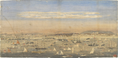 Mission to Seafarers Victoria
Print - Reproduction, Wilbraham Frederick Evelyn Liardet, View of the North Shore, Port of Melbourne, 1862
Liardet, W. F. E. (Wilbraham Frederick Evelyn), 1799-1878 depicts the busy port of Melbourne showing many types of ships and the Bethel Church built in 1860 on the Custom House land. The church replaced the Bethel ship which sank in February 1860.This watercolour along with the Francois Cogne print from 1863, "Sandridge from Hobson's Bay, and the engraving "A Bird's-eye View Of Melbourne From Sandridge" dating from 1882, is a rare depiction fo the Bethel church. In 1887, the church was demolished to erect the building still standing on the corner of Nott Street and Beach Road.wilbraham liardet, sandridge, port, ships, port melbourne, hobsons bay, bethel church, reverend kerr johnston, 1812-1887, missions to seamen, 1862, customs house -
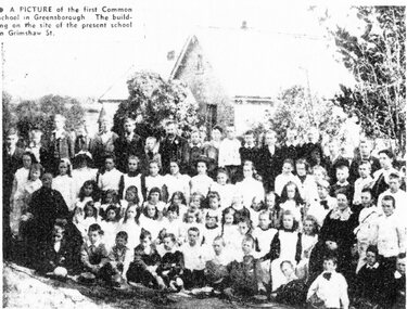 Greensborough Historical Society
Newspaper Clipping (copy), Greensborough Common School, 1860s
The first school in Greensborough was a Denominational School on the Church of England site corner Grimshaw and Church Streets. In 1863 the Denominational Schools Board was disbanded and the school became known as a Common School. It later moved to the present site of Greensborough Primary School which was established in 1878.Enlargement of copy of newspaper clipping, black and white text and image.greensborough common school, greensborough primary school