Showing 4324 items
matching form photograph
-
 Eltham District Historical Society Inc
Photograph, Untitled
Source: Royal Historical Society of VictoriaThis photo forms part of a collection of photographs gathered by the Shire of Eltham for their centenary project book,"Pioneers and Painters: 100 years of the Shire of Eltham" by Alan Marshall (1971). The collection of over 500 images is held in partnership between Eltham District Historical Society and Yarra Plenty Regional Library (Eltham Library) and is now formally known as the 'The Shire of Eltham Pioneers Photograph Collection.' It is significant in being the first community sourced collection representing the places and people of the Shire's first one hundred years.Digital imagesepp, shire of eltham pioneers photograph collection, other areas -
![Photograph, Diggers on the road to a rush [picture] / S. Prout; J. Godfrey](/media/collectors/4f729f7b97f83e03086018a5/items/5ad0683a21ea761b747a50b2/item-media/5d4452b021ea673c58e786f2/item-fit-380x285.jpg) Eltham District Historical Society Inc
Eltham District Historical Society IncPhotograph, Diggers on the road to a rush [picture] / S. Prout; J. Godfrey
Source: Royal Historical Society of VictoriaThis photo forms part of a collection of photographs gathered by the Shire of Eltham for their centenary project book,"Pioneers and Painters: 100 years of the Shire of Eltham" by Alan Marshall (1971). The collection of over 500 images is held in partnership between Eltham District Historical Society and Yarra Plenty Regional Library (Eltham Library) and is now formally known as the 'The Shire of Eltham Pioneers Photograph Collection.' It is significant in being the first community sourced collection representing the places and people of the Shire's first one hundred years.Digital imagesepp, shire of eltham pioneers photograph collection, other areas -
 Eltham District Historical Society Inc
Photograph, Floodwaters, Diamond Creek, Eltham, 1934
The Diamond Creek in flood near the Main Road bridge at Eltham, Victoria. The Yarra also was in flood. In early December 1934 the "Greatest flood in the history of the Yarra" occured, according to The Argus newspaper. Bridges and houses were swept away with hundreds of people left homeless across the state. The historic 1934 flood of the Diamond Creek and Yarra River set the criteria for future planning with respect to flood water rise.This photo forms part of a collection of photographs gathered by the Shire of Eltham for their centenary project book, "Pioneers and Painters: 100 years of the Shire of Eltham" by Alan Marshall (1971). The collection of over 500 images is held in partnership between Eltham District Historical Society and Yarra Plenty Regional Library (Eltham Library) and is now formally known as 'The Shire of Eltham Pioneers Photograph Collection.' It is significant in being the first community sourced collection representing the places and people of the Shire's first one hundred years.Digital image 4 x 5 inch B&W Neg (2 frames on one neg) 9 x 15.5 cm B&W printflooding, eltham, shire of eltham pioneers photograph collection, sepp, diamond creek (river), floods, 1934 flood, diamond creek -
 Eltham District Historical Society Inc
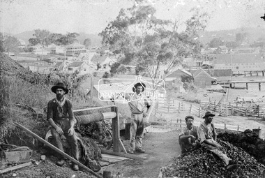
Photograph, Early Goldmine
Four male gold miners pose for the camera on their mine site on top of a hill. It appears they are using the underground hard-rock method of mining to extract gold encased in rock. There is a rope winch near by and a pile of rubble on top of the mine shaft. In the background is a developed unknown rural town. "H & J Friend Victoria Stores" is written on the side of a building.This photo forms part of a collection of photographs gathered by the Shire of Eltham for their centenary project book, "Pioneers and Painters: 100 years of the Shire of Eltham" by Alan Marshall (1971). The collection of over 500 images is held in partnership between Eltham District Historical Society and Yarra Plenty Regional Library (Eltham Library) and is now formally known as 'The Shire of Eltham Pioneers Photograph Collection.' It is significant in being the first community sourced collection representing the places and people of the Shire's first one hundred years.Digital imagesepp, shire of eltham pioneers photograph collection, other areas, gold mining, gold miners, h & j friend, winch -
 Eltham District Historical Society Inc
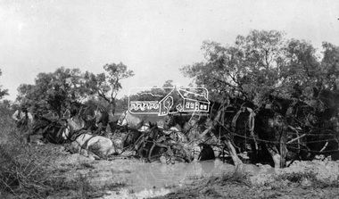
Photograph, Horses in Difficulty
A team of eleven horse (probably twelve) harnessed together bogged down in mud. Unknown location and date.This photo forms part of a collection of photographs gathered by the Shire of Eltham for their centenary project book "Pioneers and Painters: 100 years of the Shire of Eltham" by Alan Marshall (1971). The collection of over 500 images is held in partnership between Eltham District Historical Society and Yarra Plenty Regional Library (Eltham Library) and is now formally known as'The Shire of Eltham Pioneers Photograph Collection.' It is significant in being the first community sourced collection representing the places and people of the Shire's first one hundred years.Digital imagesepp, shire of eltham pioneers photograph collection, other areas, horses, mud, stuck, bogged -
 Eltham District Historical Society Inc
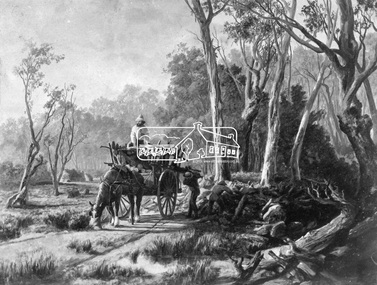
Photograph, Collection of wood
Etching of country scene, a horse pulling a rudimentary cart with three men collecting wood and possibly stones from underneath trees on a rough track. Two huts are in the background. Early settlers often had to make use of what was available in their local environment to build their shelters. Today roadside collection of firewood is regulated by the State government. Unknown location, unknown artist and unknown date.This photo forms part of a collection of photographs gathered by the Shire of Eltham for their centenary project book," Pioneers and Painters: 100 years of the Shire of Eltham" by Alan Marshall (1971). The collection of over 500 images is held in partnership between Eltham District Historical Society and Yarra Plenty Regional Library (Eltham Library) and is now formally known as 'The Shire of Eltham Pioneers Photograph Collection.' It is significant in being the first community sourced collection representing the places and people of the Shire's first one hundred years.Digital imagesepp, shire of eltham pioneers photograph collection, other areas, pioneer life, country scene, country roads -
 Eltham District Historical Society Inc
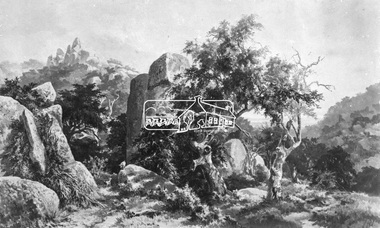
Photograph, Rocky Outcrop
A rural location with a visible exposure of bedrock surrounded by vegetation and trees. A rock exposed high hill is in the background. The location and artist are unidentified. The location is reminscent of Hanging Rock, Woodend.This photo forms part of a collection of photographs gathered by the Shire of Eltham for their centenary project book, "Pioneers and Painters: 100 years of the Shire of Eltham" by Alan Marshall (1971). The collection of over 500 images is held in partnership between Eltham District Historical Society and Yarra Plenty Regional Library (Eltham Library) and is now formally known as 'The Shire of Eltham Pioneers Photograph Collection.' It is significant in being the first community sourced collection representing the places and people of the Shire's first one hundred years.Digital imagesepp, shire of eltham pioneers photograph collection, other areas, rocks, bedrock, unknown -
 Eltham District Historical Society Inc
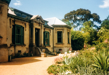
Photograph, Buda, Castlemaine, Spring Gardens Excursion, 30 October 1988, 30/10/1988
[from EDHS Newsletter No. 62, September 1988:] SPRING GARDENS TRIP 30 Oct 1988 On this trip we will be visiting gardens which are of historic interest or of old world character. The date has been selected to coincide with the time when the gardens are likely to be at their best. The Central Victorian Goldfields area has been selected because it offers a wide range of gardens open to the public. From this range we have chosen three gardens which we think will be of great interest to members and their families and friends. These are the gardens: • "Buda", Castlemaine: One of Victoria's most famous historic gardens. The mansion, which was the home of the Leviny family for 118~ years, is also open for inspection. • "Badger's Keep", Chewton: This is a cottage garden (complete with 100 year old cottage) with a great diversity of plants. • "The Springs", Sedgwick: A country garden also with a great array of plants. The cost of the bus is $9.00 for adults and $5.00 for children. There is an additional charge for entry to the gardens, $2.00 each for "Badger's Keep" and "The Springs"; for "Buda" it is $3.00, $1.50 for pensioners and $1.00 for children. Each of the gardens has plants for sale. Bring your own picnic lunch. Please be at the Eltham Shire Offices by 8.15 a.m. so we can leave promptly at 8.30. To book for this trip complete the attached form and return the appropriate fare. [from EDHS Newsletter No. 63, November 1988:] RECENT ACTIVITIES More recently the Spring Gardens trip attracted a full bus load and a waiting list. Those who went thoroughly enjoyed the historic garden and mansion at "Buda" and two other excellent gardens at "Badger's Keep" and "The Springs". The popularity of this trip warrants a repeat performance. There are a number of other gardens of historic and general interest which are worth a visit in the future.Two colour photographsactivities, buda, castlemaine -
 Eltham District Historical Society Inc
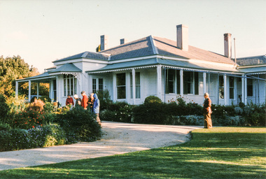
Photograph, Mulberry Hill, Golf Links Road, Baxter; Spring Excursion to The Briars and Mulberry Hill, 27 October 1991, 27/10/1991
[from EDHS Newsletter No. 80, September 1991:] SPRING EXCURSION: As usual for October we have arranged a bus tour outside the local area. We will leave from the Eltham Shire Offices at 9.00 am on Sunday 27th October and travel to "The Briars" at Mornington and "Mulberry Hill" at Baxter. The cost will be $16.00 for adults and $8.00 for children. This includes admission to each of the houses and afternoon tea at "Mulberry Hill". Bring your own lunch to eat at "The Briars" and something for morning tea if you wish. "The Briars" is one of the oldest pastoral stations on the Mornington Peninsula. It has historical associations with the early settlement of the district and with Alexander Balcombe who settled in the area about 1843. Near the house is a wetland wildlife reserve with walking paths and bird observation hides. "Mulberry Hill" was the home of Sir Darryl Lindsay and his wife Joan. Darryl (1889-1976) was a member of the famous art family of Lindsays and was a prominent artist in his own right. He was also a noted art administrator, being appointed Director of the National Gallery of Victoria in 1942. Joan Lindsay (1896-1984) was an important writer. Her best known work was "Picnic at Hanging Rock". Members may find it interesting to read her autobiography "Time Without Clocks" prior to this trip. Members are welcome to bring their friends. Bookings will only be confirmed on payment. Please complete the attached form and return with payment to the September meeting or to our post office box. The trip is still some time off but there is no further Newsletter before then. Note the date in your diary how. As this will probably be the first day of daylight saving you will need to remember that in organizing yourself on the day. Please arrive at 8.45 am ready for a prompt start at 9.00 am.Two colour photographsactivities, mulberry hill, the briars -
 Eltham District Historical Society Inc
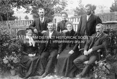
Photograph, Gulf Station, Yarra Glen. Members of the Bell Family, 1905c
Mrs Bell and her adult children of Gulf Station, Yarra Glen. Standing Jack (John), Jemima, Andrew. Seated Mary Ann (mother of all the others), Frank (Francis), Dinah and Bill (William). Scottish settlers Agnes and William Bell were the first to lease the land where the property was established in the 1850s. Gulf Station was farmed for nearly 100 years by the Bell family.This photo forms part of a collection of photographs gathered by the Shire of Eltham for their centenary project book,"Pioneers and Painters: 100 years of the Shire of Eltham" by Alan Marshall (1971). The collection of over 500 images is held in partnership between Eltham District Historical Society and Yarra Plenty Regional Library (Eltham Library) and is now formally known as 'The Shire of Eltham Pioneers Photograph Collection.' It is significant in being the first community sourced collection representing the places and people of the Shire's first one hundred years.Digital imagesepp, shire of eltham pioneers photograph collection, yarra glen, bell family, gulf station, dianah bell, frank bell, jack bell, jimima bell, mary ann bell, william bell -
 Eltham District Historical Society Inc
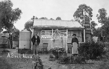
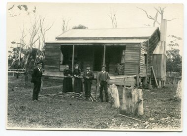
Photograph, Tom Prior, A Bush Home - Research, Vic, c.1895
A slab hut situated in Research, Victoria. An elderly man and woman stand in front of their small bark slab home with bark chimney. It has a tin roof and tin water tank to the side. A small garden is situated at the front. Reproduced on pp 38-39 of 'Pioneers & Painters: One Hundred years of Eltham and it's Shire" (1971) Article in "Australian Family Tree Connections" February 2000 by B. J. Parkinson claims that the people in this photo are "Jonas and Christina Jane (Gregg) PRIOR in front of their home at Ferny Hill, near Eltham, Victoria, 1877". Photocopy of photo also attached to 14 online family trees for the Prior family on Ancestry.com without the words "A Bush Home". References found to Prior in historical newspapers and the property "Ferny Hill". Jonas was a convict from Kent, England. He arrived in Hobart in 1821 aged 19 years. He married Christina Gregg in Hobart about 1834 and had 11 children. They came to Victoria about 1846. He died at Ferny Hill, near Research, Eltham in 1878 aged 74 years and was buried at Melbourne General Cemetery. His occupation was gardener.This photo forms part of a collection of photographs gathered by the Shire of Eltham for their centenary project book,"Pioneers and Painters: 100 years of the Shire of Eltham" by Alan Marshall (1971). The collection of over 500 images is held in partnership between Eltham District Historical Society and Yarra Plenty Regional Library (Eltham Library) and is now formally known as the 'The Shire of Eltham Pioneers Photograph Collection.' It is significant in being the first community sourced collection representing the places and people of the Shire's first one hundred years.Digital image 4 x 5 inch B&W Neg Print 20 x 25 cmshire of eltham pioneers photograph collection, research (vic.), ferny hill, jonas prior, christina prior, hut, prior, convict, pioneers and painters -
 Eltham District Historical Society Inc
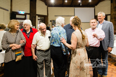
Photograph, Peter Pidgeon, Members of the 2017 Committee forming another sub-committee, 2710/2017
... Committee forming another sub-committee Photograph Peter Pidgeon ...Eltham District Historical Society's 50th Anniversary dinner held at St Margaret's Hall, Pitt Street, Eltham, 27 October, 2017Born Digital50th anniversary, eltham district historical society, st margarets anglican church -
 Orbost & District Historical Society
programs, 1961
The Snowy River Shire was a local government area in the Australian Alps region of New South Wales, Australia from 1939 until May 2016. It was named after the Snowy River that runs through it. Prior to 1936, it had been named as Dalgety Shire since establishment in 1906. This opening of the Monaro - Gippsland Road took place on 4th May 1961. There had long been a movement in Monaro for the construction of a road to connect Monaro and Gippsland, via Inglebyra and Black Mountain. The only track was for stock, made by pioneers many years ago, and it was very circuitous. It was stated at a meeting at Dalgety that the road would open up large areas for settlement for grazing, and for timber suitable for bridgé building. The road would assist stock deal ing between Monaro and Gippsland. It would also considerably shorten the distance from Victoria for tourists visiting Canberra and Kosciusko. A committee was formed to put the proposal before the Dalgety Shire Council in the 1930s.This item is a useful research tool.Four copies of a road opening program. It has black print on white. There are black / white photographs, historical details and details of the official opening.program monaro-road snowy-river-shire -
 Orbost & District Historical Society
newspaper clippings
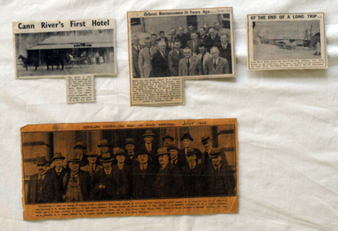
This collection of articles was collated by Mary Gilbert. 743.1 - In the group are, from left to right:—First Row—Councillors T. W. Murphy (Bairnsdale), J. R. Coate (Lakes Entrance); T. Hodgd (Tambo), W. Wilson (Berwick), A. Inglis (Mirboo), E. S. Whittakers (Traralgon), and W. C. Kingston (Warragul). Second Row—J. S. Lister (Rosedale), R. Stockdale (Narracan), W. Grose (Omeo), and J. Allan (Toora). Back Row—S. Purdy (Maffra), E. Heesom (Morwell), J. Arohibald (Bruthen), Mr. Lind, M.L.A., Councillor A. E. Rodwell (Orbost), Mr. S. Langslow (Health department), and Mr. C. S. Ogllvy (Warragul). A manila folder of newspaper cuttings related to commerce and government in Orbost. 743.1 is titled, " Gippsland Councillors Wait on State Ministers and is from The Argus, July 1926 .It has a large black / white photograph of the representatives of shires and boroughs of Gippsland who formed a deputation to meet which waited most of the State Ministers with various requests. 743.4 is from the Snowy River Mail and is titled, "Cann RIver's first Hotel" and has a black and white photograph of a four-wheeled buggy pulled by four horses standing outside a hotel. 743.5 is titled "At the End of a Long Trip" and is from the Snowy River Mai. It has a black and white photograph of the Cann River hotel with Mr W. Dreverman standing outside. 743.6 is from the Snowy River Mail, September 6, 1967, and is titled, " Orbosr Businessmen 20 Years Ago" and has a black and white photograph of a group of men in business suits.orbost-business cann-river-hotel -
 Orbost & District Historical Society
black and white photograph, Wilson, Les G, 1919
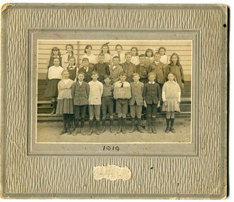
The 19th of March 1886 proved an important day in the lives of many early settlers in the Orbost area, because on this day the Orbost State School opened. The fact that the school had first operated temporarily in a leased building, and on a half-time basis with SS2745 Jarrahmond, did not dampen the enthusiasm of the local inhabitants as they saw their offspring commence their education under the guidance of HT Campbell Mackay. However he remained in charge only until 12th of May 1886. The second HT, John Rowe, served until 1908. On 30th of June 1887, a portable room was provided; it being brought to the area by schooner. The school now had accommodation for 30 pupils; the teacher's welfare was considered because quarters of two rooms were attached. As the population increased so did the needs of the school. This was reflected in the provision of a larger classroom in 1898. During 1910-11 the first approaches were made to the Department for the establishment of a HES in Orbost and this became a reality in 1912. Orbost HES supplied post-primary education in the district until a high school was built in 1948. When fire destroyed the school in 1941 local halls were used as classrooms until a new school was built. Work was quite rapid and a new brick structure was opened by the Hon. A. E. Lind, MLA, on 13th of February 1942. This new building was a fine type of school of which both the pupils and the HT Leslie Collins were indeed proud. But Orbost continued to develop and the new school was soon overtaxed. This resulted in the erection of two Bristol classrooms in 1947. By 1950, when the school population had reached 500 pupils the opening of the new school at Orbost North was welcomed by all concerned. In 1963 the Department purchased land diagonally opposite the school and developed it as a playing area. In 1965 two LTCs were opened in November, and in October 1968 the Brodribb School building was moved to SS2744 Orbost for use as a general purpose room. ( Info. from Schools East Gippsland) This item is associated with the history of education in Orbost.A black / white photograph on a grey buff cardboard frame. It is of a group of students standing outside the Orbost State School building. One child holds a sign reading "Form F". There is a photographer's label at the bottom.on back - "Alen Roach" on front - "1919" education-orbost orbost-state-school -
 Ringwood and District Historical Society
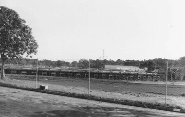
Photographs, Construction Stage of historical Miner's Cottage Museum completed 1983, and panoramic view of partial construction of commercial buildings on former Ringwood Market site, Seymour Street, Ringwood c.1970s. On cardboard
... ; 3964/2 4 photographs on cardboard 85.5cmX22.5cm forming... Road Ringwood North melbourne 3964/1 15 photographs ...3964/1 15 photographs on cardboard 76cmX51cm depicting construction stages of historical Miner's Cottage Museum completed 1983; 3964/2 4 photographs on cardboard 85.5cmX22.5cm forming panoramic view of partial construction of commercial buildings on former Ringwood Market site, Seymour Street, Ringwood c.1970s -
 Ringwood and District Historical Society
Photograph, View of forming of ground floor of Target 1981
Written on back of photograph, "6/6/81. View of forming of ground floor of Target." -
 Ringwood and District Historical Society
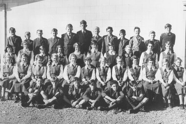
Photograph, Ringwood High School - 1954, Form 1A. Boys standing (L-R): 1. Ian Kilpatrick, 2. Keith Anderson, 3. Peter Zaff, 4. Jim Ord, 5. Gordon Burnett, 6. Tim Pinninger, 7. Geoff Giggings, 8. Bernard Whitney, 9. Andrew Termouth, 10. Clive Kettle, 11. Robert Tozar 12, Frank Stubbs. Girls standing: 1. Janet Johns, 2. Norma Walsh, 3. Marilyn Bird, 4. Doris Hemell, 5. Lynette Jungwirth, 6. Janice Hunt, 7. Sandra Davenport, 8. Margaret Williams, 9. Margaret Norwood, 10. Lorrice Stratton. Girls seated: 1. Kathleen Lowe, 2. Valma McLean, 3. Sandra Tyndal, 4. Gillian Morris, 5. Esma Bradley, 6. Jill Pump, 7. Judy Byrne, 8. Shirley Kofeod, 9. Marlene Mangels, 10. Pam Erlandsen, 11. Myrna Cooper, 12. Elizabeth Hinchcliffe. Boys seated: Robert Crutchfield, 2. Stuart Barclay, 3. James McAleese, 4. Robert Horkings, 5. John Smart, 6. Ronald Crutchfield
+Additional Keywords: Reading from Left to Right: Back row boys: 1. Alan Carter, 2. ??, 3. Maurice Henry, 4. Peter Van Ketwich, 5. Douglas Hume, 6. ??, 7. John Callam, 8. ??, 9. ??, 10. ??, 11. Peter Gluth, 12. ??, 13. Geoff Edwards, 14. Len Armfield, 15. Ray Davidson".(incorrect list)Written on backing sheet, "Ringwood High School. 1956?" No children are identified.Paper list with photographs reads, "High School - Bedford Rd. Ringwood. Photo Pupils Form 1C. Reading from Left to Right. Back row boys: 1. ?, 2. Keith Anderson, 3. Peter Zaff, 4. Jim Ord, 5. ?, 6. ?, 7. ?, 8. Bernard Whitney, 9. ?, 10. ?, 11. ? 12, ?. Boys sitting front: Robert Crutchfield, 2. ?, 3. ?, 4. ?, 5. John Smart, 6. Ronald Crutchfield. Girls standing: 1. ?, 2. Norma Walsh, 3. ?, 4. ?, 5. ?, 6. ?, 7. Sandra Davenport, 8. Margaret Williams, 9. Margaret Norwood, 10. ?. Girls sitting: 1. Kathleen Lower, 2. Valma McLean, 3. Sandra Tindall, 4. Gilliam Morris, 5. Esma Bradley, 6. Jill Pump, 7. Judy Byrne, 8. Shirley Kofeod, 9. Marlene Mangels, 10. ?, 11. Myrna Cooper, 12. Elizabeth Hinchcliffe. -
 Ringwood and District Historical Society
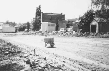
Photograph, Lane from Adelaide St Ringwood (widening) and Jack Orr's shed 1958
Written next to photographs (mounted on single sheet of paper): SS0182a: "Lane from Adelaide Street to Melbourne Street being widened to form street." SS0182b: "Shed on left used by Jack Orr for making steel cloths hoists. Nov. 1958" -
 Ringwood and District Historical Society
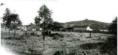
Photograph, Edwin G. Adamson A.R.P.S, Vacant land back of Adelaide St. houses, Ringwood 1963 (Eastland Litigation Photos)
This series of SS0380 photos are part of the "Eastland Litigation" launched in 1962 by the Whitehorse Traders Co-operative Association (WTCA), against the Ringwood Council's Interim Development Order of 1960. WTCA sought "orders from the Supreme Court of Victoria that the planning scheme was invalid" - See "The Eastland Litigation" chapter in "From Horse Shoes to High Heels - Ringwood Shopping Centre and Eastland 1858-2008" by Richard Carter, Bounce Books 2009.2 photos taped to form a long horizontal photo. This taped photo was scanned in two parts and then merged using Photoshop. The two parts and the merged image are attached.Written on back of picture, 'Vacant land backs of Adelaide St. houses'. Stamped on back, 'In the Supreme Court - 13 Aug 1963' and 'Edwin G. Adamson....July 63'. -
 Ringwood and District Historical Society
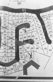
Photograph, Plan of Lots in Bel-Air Estate 1991
4 photographs of sections of the plans.a. Written on back of photograph, "20/6/81. Plan of Bel Air Estate. Werac Drive runs down left side of plan. Kubis Drive crosses top. Debbie Place drops down from Kubis. Manuela Tce. runs right from Werac, ends at a bend and becomes Rudolf Court running North. Lyn Court takes off right from Rudolf and Burlock Ave. touches estate with an elbow" b. Written on back of photograph, "20/6/81. Plan of lots in Bel Air Estate. Glenvale Road down left side of plan, Kubis Dr. Runs across picture. June Square drops from and Jenken Close rises form Kubis Dr. Werac Dr. drops to bottom of picture and Manuella takes off to right". d. Written on back of photograph, "20/6/91. Lots in Bel-Air Estate. Kubis Dr. rises from bottom left to Oban Road top. Pamela Crt. drops from Kubis at left, Iluka Crt. takes off right. Whitlam Dr. runs left at top and Menzies Cr. drops off it to centre of picture". c. Written on back of photograph, "20/6/81. Plan of lots on Bel-Air Estate. Kubis Dr., Debbie Place, Pamela Crt, Iluka Crt. Menzies Drive" -
 Orbost & District Historical Society
black and white photograph, Howard D. Bulmer, early 20th century 1920s?
This is a photograph of An Orbost Agricultural Show Committe. The first meeting to form an Agricultural society in Orbost was convened by the then Orbost Progress Association and held in the Mechanics Hall on Saturday, 10th October 1891. Its first show was held on 3rd March 1904...on a site alongside the Bonang Road where the present Golf Club stands. It is currently held at the Recreation Reserve at Newmerella. (Ref: In Times Gone By-Deborah Hall) This photographs is associated with the Orbost Agricultural Society 's Annual Show which has been a major event in Orbost for over a century. Agricultural shows are an important part of cultural life in small country towns and the Orbost Show is an integral part of Orbost 's agricultural history. A large Black / white photograph on grey card. It shows two rows of men. The back row is standing and the front sitting. They are posed in front of a wooden building with an open door. On the left is a water tankon front - Howard D. Bulmer Photographer on right - hand-written < Jack Gilbert X on back - hand-written - L_R Arthur Rodwell, Mat Lynch, Rupert Mosely, S. Lynn, A. Pardew, John Gilbert, John Bird on sticker - "Take off man marked X Mr Matthew Lynch of Orbost"photograph-orbost-agricultural-society -
 Orbost & District Historical Society
black and white photograph, Neville Huon, 1939
During 1910-11 the first approaches were made to the Department of Education for the establishment of a Higher Elementary School in Orbost and this became a reality in 1912. Orbost Higher Elementary School supplied post-primary education in the district until a high school was built in 1948. Higher Elementary schools took in students whose parents desired a higher level of education than the completion of Grade 6. Higher elementary classes were added to existing primary schools and were the forerunners of high schools. Orbost High School / Orbost Secondary College has played a significant part in the education of senior students in the Orbost district . It is the sole senior educational institution. This photograph is representative of its history.A black / white photograph mounted on grey card. it shows three rows of students and teachers in font of a brick building. They are dressed in uniforms with ties and blazers.on back - 1939 D & C FORMS Nance Gilbert front row 3rd from righteducation-orbost higher-elementary-school-orbost gilbert-nance -
 Orbost & District Historical Society
black and white photographs, 1934
These photographs were taken just after the McKillop's Bridge was completed after the flood damage. The current McKillop’s Bridge was built by the Country Roads Board in two stages between 1931-36, during which its height was raised after the original bridge superstructure was washed away in record floods of January 1934, prior to its original official opening. In its reconstructed form the original concrete abutments were turned into additional piers and the welded-steel trusses were cantilevered back over them to meet the new higher road approaches. It is sited at McKillops Crossing, named after pioneer overlanding squatter George McKillop who crossed here in 1835. This was a stock crossing place for almost a century before the bridge was constructed. (info. from Victoria Heritage Register)This is a pictorial record of the history of McKillop's Bridge, in itself of historical significance for its association with Victoria's long and important pastoral history, its technicl significance and aesthetic significance.Three black / white photographs. 3133.1 shows the approach to a washed away bridge. 3133.2 is of a bridge over a river with men clearing debris. 3133.3 is a close-up showing the wreckage of the bridge.mckillop's-bridge snowy-river flood-damage-1934 -
 Orbost & District Historical Society
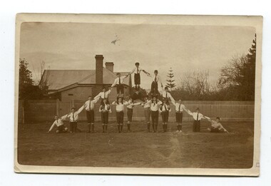
black and white photograph, Nielson, Leslie, 1920s ?
These students are possibly from the Orbost State School. After WW1 many community organisations such as church groups, and youth groups began to run gymnastics, including ‘gymnastics circuses’. This is a pictorial record of school students in the first half of the 20th century.A black / white photograph of a group of boys dressed in school uniforms forming a pyramid with some standing on the shoulders of others. the photograph has been taken outside.orbost-state-school sport-gymnastics -
 Orbost & District Historical Society
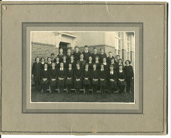
black and white photograph, C 1922
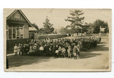
DESCRIPTIONA black / white photograph on a grey buff cardboard frame. It is of a group of students standing outside the Orbost State School building. One child holds a sign reading "Form F". There is a photographer's label at the bottom.SIZEH-199mm W-028mmOBJECT REGISTRATION890KEYWORDSeducation-orbost orbost-state-schoolHISTORICAL INFORMATIONThe 19th of March 1886 proved an important day in the lives of many early settlers in the Orbost area, because on this day the Orbost State School opened. The fact that the school had first operated temporarily in a leased building, and on a half-time basis with SS2745 Jarrahmond, did not dampen the enthusiasm of the local inhabitants as they saw their offspring commence their education under the guidance of HT Campbell Mackay. However he remained in charge only until 12th of May 1886. The second HT, John Rowe, served until 1908. On 30th of June 1887, a portable room was provided; it being brought to the area by schooner. The school now had accommodation for 30 pupils; the teacher's welfare was considered because quarters of two rooms were attached. As the population increased so did the needs of the school. This was reflected in the provision of a larger classroom in 1898. During 1910-11 the first approaches were made to the Department for the establishment of a HES in Orbost and this became a reality in 1912. Orbost HES supplied post-primary education in the district until a high school was built in 1948. When fire destroyed the school in 1941 local halls were used as classrooms until a new school was built. Work was quite rapid and a new brick structure was opened by the Hon. A. E. Lind, MLA, on 13th of February 1942. This new building was a fine type of school of which both the pupils and the HT Leslie Collins were indeed proud. But Orbost continued to develop and the new school was soon overtaxed. This resulted in the erection of two Bristol classrooms in 1947. By 1950, when the school population had reached 500 pupils the opening of the new school at Orbost North was welcomed by all concerned. In 1963 the Department purchased land diagonally opposite the school and developed it as a playing area. In 1965 two LTCs were opened in November, and in October 1968 the Brodribb School building was moved to SS2744 Orbost for use as a general purpose room. ( Info. from Schools East Gippsland)This item is associated with the history of education in Orbost.A black / white photograph of a large group of children standing outside a school building - " Orbost State School No. 2744". The younger students are standing in the front. High School students are at the back.on back - "Mr C. Connor S.M. Mr Tipper H.M. State & H.E.s. about 1922"education-orbost orbost-state-school orbost-higher-elementary-school -
 Orbost & District Historical Society
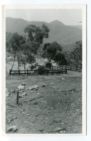
black and white photograph, mid 1930s
This is a photograph of McKillop's Bridge probably taken just after its rebuilding. The current McKillop’s Bridge was built by the Country Roads Board in two stages between 1931-36, during which its height was raised after the original bridge superstructure was washed away in record floods of January 1934, prior to its original official opening. In its reconstructed form the original concrete abutments were turned into additional piers and the welded-steel trusses were cantilevered back over them to meet the new higher road approaches. "McKillops Bridge was Heritage listed due to its social and technological significance – the steel trusses' arc-welded construction technique was a pretty big deal in the 1930s. It was once an important route for cattlemen, who used the ford across the Snowy in the years preceding the bridge's existence"This is a pictorial record of McKillop's Bridge just after its construction.A black / white photograph of a wooden bridge across a river. At the bottom right is a man with his back to the camera. He is looking at flood debris on the bank. At the bottom left are two men near a pylon.on back - McKillops Bridgebridge-mckillop's snowy-river-bridge -
 Orbost & District Historical Society
black and white photograph, July 1897
Snowy River Shipping Company formed in 1880. They were soon shipping produce (mainly vegetables) from the area to Melbourne. The Snowy River Shipping Company was formed by Mr Henry James during the 1880s, with Captain McNeil as master. Captain McNeil was an always cheerful Marlo identity and local children had many times sailing with him on the river. Captain McNeil with tug went out through the entrance and brought in the schooners.This photograph is associated with an early Marlo identity.A black / white photograph of five people, three men and two women, standing in front of a wooden cottage. The man on the left is wearing what appears to be a ship's captain's uniform.on back - "Capt. McNeil in front of house, Marlo, July 1897" -
 Orbost & District Historical Society
black and white photograph, early 20th century
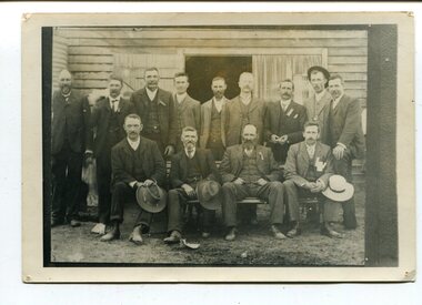
This is probably a photograph of An Orbost Agricultural Show Committee. Those in the photograph are: Back L-R Archie Rodwell; Rupert Mosley; A. Pardew; John Gilbert. Front - Bill Cummings; Draffin; John Johnstone. The first meeting to form an Agricultural society in Orbost was convened by the then Orbost Progress Association and held in the Mechanics Hall on Saturday, 10th October 1891. Its first show was held on 3rd March 1904...on a site alongside the Bonang Road where the present Golf Club stands. It is currently held at the Recreation Reserve at Newmerella. (Ref: In Times Gone By-Deborah Hall)This photographs is associated with the Orbost Agricultural Society 's Annual Show which has been a major event in Orbost for over a century. Agricultural shows are an important part of cultural life in small country towns and the Orbost Show is an integral part of Orbost 's agricultural history.A black / white photograph of a group of men, dressed in suits, standing in outside a wooden building. The front row is seated and the back row standing.on back - 'Pop on N.E. Corner"orbost-agricultural-society -
 Orbost & District Historical Society
Postcard - post card, early 20th century
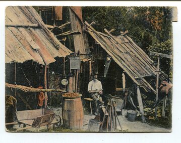
This postcard was produced as a black and white card titled, "Early 1900 - Bush Hut , Gippsland", in the early 20th century. The original card had a blank white rectangular strip on the right side of the photograph. This was for the message. There is little information with this item except for a note indicating that it was a hut at Newmerella. This is a pictorial record of a bark hut of the kind built by the early settlers of East Gippsland. Few early settlers could afford the time, or possessed the capital, to build any dwelling more impressive than a slab hut: Postcards form a vital part of social and historical records for researchers. A postcard showing a bearded man sitting on a stool outside a bark hut. There are various tools - a wheelbarrow and shovels, buckets, a panning dish and a saw hanging above him to the left. . It is in a bush setting and the photograph has been tinted.on back - POSTCARD - in red :"Essie & Ruby McKena. Emily Ville, Ascot Vale Road Flemington"dwelling-bush hut-bark