Showing 3052 items
matching highway
-
 Melbourne Tram Museum
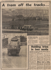
Newspaper, The Sun, “A tram off the tracks”, 22/10/1977 12:00:00 AM
“A tram off the tracks” The Sun, Saturday, Oct 22, 1977 Photos and text Tram # 86 Photos of tram # 86 being transported on semi-trailer on Hume Highway at Beveridge on its way to Orange, NSW. Part of display by Bathurst-Orange Development Corporation, planning to build a new town between the two cities. Trams among the different types of transport being considered to link the proposed town to its neighbours. Tram displays “Brunswick-Moreland Rd” and route number 954.trams, tramways, displays, trucks, z class, transporting trams, tram 86 -
 Lakes Entrance Historical Society
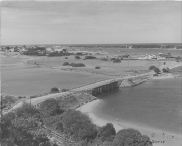
Postcard - Lakes Entrance 1945, 1945c
North Arm Bridge and TownColour photograph of bridge across North Arm, showing town and Club Hotel; jetties in Cunninghame Arm; sand dunes; and concrete brick toilet block built beside Highway between Club Hotel and North Arm. Concrete brick toilet block opposite road to Bullock Island built after World War 2 bricks made on Kimmels Farm, toilet at Harbecks Wharf and cricket club pavilion built same era. Lakes Entrance Victoriatownship, hotels, bridges -
 Orbost & District Historical Society
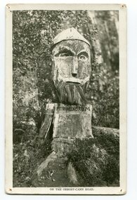
black and white photograph, 1920s
Pons asinorum was the name given to a wooden carving made by road worker Finlay Munro in the early 1920s at Boulder Creek, on the old Princess Highway, between Orbost and Cann River. The carved face was said to mock the supervising engineer after an argument about putting the road alignment across a swamp that required new bridges. The Italian workmen had advocated for a different route to avoid the need for building new bridges across the swamp. This photograph is from a set of thirteen black and white postcards in a fold-out format.This is a photograph of an iconic tourist attraction which records the woodworking skills of workers in the early 20th century. The carving is no longer there.A small black / white photograph of a face carved into a tree stump.on front at bottom - ON THE ORBOST CANN ROADwoodcarving pons-asinorum boulder-creek-east-gippsland princess-highway -
 Warrnambool and District Historical Society Inc.
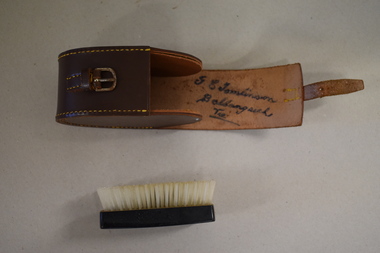
Clothes brush & holder, Mid 20th century
The brush in this case could have been used as a hair brush or a clothes brush. It is enclosed in a leather case and was probably an item made for travellers. The brush and case belonged to George Tomlinson of Ballangeich. Ballangeich is a small settlement on the Hopkins Highway about 27 kilometres from Warrambool. George Tomlinson’s grandfather, William Tomlinson , established a farming property at Ballangeich in 1865 and opened a hotel, ‘Half Way House’ on part of the land. George Tomlinson’s father, also William, continued to farm in the area and was known as a fine judge of cattle and sheep. This case and brush are of interest as an example of the brushes men used in the mid 20th century. The items are also of interest as they belonged to a member of a well-known Ballangeich family (Tomlinsons).1 This is a piece of brown leather rolled over and stitched with yellow thread to form a container or case. The case has a closing mechanism – a leather strap and metal buckle. .2 Inside the leather case is a brush with a brown Bakelite back with horsehair inserted. ‘G.E. Tomlinson Ballangeich Victoria’men’s toiletries, ballangeich, history of warrnambool -
 Eltham District Historical Society Inc
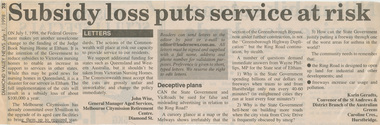
Work on paper - Newspaper article, Diamond Valley News, Subsidy loss puts service at risk, 1 July 1998
Letter to the editor published in the Diamond Valley News,, July 1, 1998 by John Wise, General Mananger Aged Services, Melbourne Citymisson Retirement Centre, Diamond St. stating the situation regarding a reduction in subsidies by the State Goverment and the organisations committment to upgrade the facilities. In 2021, Judge Book is known as St Vincent's Care Services Eltham. Another letter to the editor refers to the Ring Road / Greensborough Bypass / Greensborough Highway Duplication by Karen Geradts, convenor of the St Andrews & District Branch of the Australian Greens. judge book memorial village, aged care, melbourne city mission, seniors, funding, ring road, nursing home, aged care facility, john wise, greensborough bypass, greensborough highway, karin geradts, st andrews & district branch of the australian greens, judgebook -
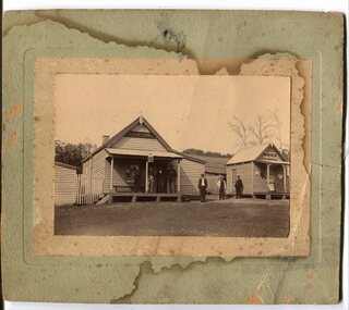 Orbost & District Historical Society
black and white photograph, early 20th century
The hotel at Bonang was also known as Clancy's Hotel, Bonang, after its licensee, William Clancy. It operated from the late 1890s until early 20th century. William Clancy was aslo the postmaster at Bonang. A post office operated at Bonang from at least 1859. At the time Bonang was "a small, scattered collection of buildings marking the intersection of the Bonang Highway and the McKillops Bridge Road" ( from Regional Heritage Assessment 1996). As the mining activity declined the township became even smaller as many of the population moved to Orbost,, a larger settlement. This is a pictorial record of Bonang, a small settlement approximately 50 km north of Orbost. The buildings in the photograph no longer exist.A black / white photograph mounted on grey card. there are stains from water damage on the mount. It is a photograph of two single-storeyed timber buildings fronting a wide dirt road. On the right is the Bonang Hotel with four men in suits standing on a verandah. The building on the right is the Bonang Post Office and there are three men outside it. the photograph has been posed. on back - 'Grandma Clancy owned the hotel & Uncle Will had a gold mine which he worked"bonang bonang-post-office bonang-hotel clancy-william clancy's-hotel-bonang -
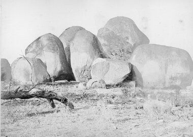 Stawell Historical Society Inc
Photograph, The Sister Rocks Pleasant Creek 1866
The Sister Rocks Pleasant Creek. Part of a collection of Photographs by Mr. O.G. Armstrong as commissioned by the Shire of Stawell for the Inter-colonial and Paris Exhibition in Melbourne in 1866. sailing ship and landed at Port Ferry. They came to Stawell from the port by bullock wagon laden with goods for the goldfield and camped at the Sister Rocks and so they were named. Later the girls married. One became Mrs Hodge and lived on the Western Highway, another became Mrs D’Arcy of the Shamrock Hotel Stawell West. The third was Mrs Moore of Levithan East Stawell. Large Granite boulders with no visible Graffiti. Log on left of photo. stawell tourism -
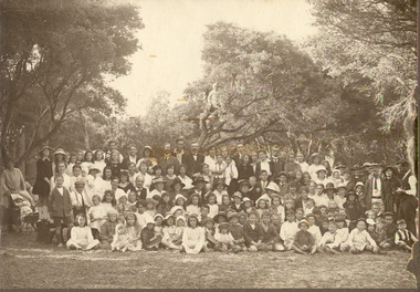 Chelsea & District Historical Society Inc
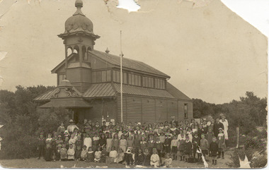
Photograph - Chelsea State School, Students, staff and Family on a picnic, c 1912-14
In January 1912, a small school was established at Chelsea, with 65 students, in Hoadley’s Hall, located on Main Road, Chelsea, near the Nepean Highway. Due to its Oriental appearance, the local people called this hall “The Joss House.” Hoadley's Hall was was originally used at the Melbourne Show Grounds by Hoadley's which was moved to Chelsea. The Hall was also used for church services by different religions before they built their own churches. A new brick school was built on Argyle Avenue and officially opened on 27 January 1915.Sepia photo of children, staff and family from Chelsea State School, at a picnic, amongst the te trees.chelsea, education, chelsea primary school, school, hoadleys hall, joss house, picnic, te trees -
 Chelsea & District Historical Society Inc
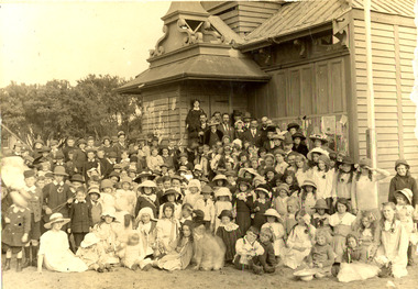
Photograph - Chelsea State School, Children outside Hoadleys Hall "Joss House", 1912
In January 1912, a small school was established at Chelsea, with 65 students, in Hoadley’s Hall, located on Main Road, Chelsea, near the Nepean Highway. Due to its Oriental appearance, the local people called this hall “The Joss House.” Hoadley's Hall was was originally used at the Melbourne Show Grounds by Hoadley's which was moved to Chelsea. The Hall was also used for church services by different religions before they built their own churches. A new brick school was built on Argyle Avenue and officially opened on 27 January 1915.Black and white photo of children at Chelsea State School, in 1912, standing in front of Hoadley's Hall.chelsea, education, chelsea primary school, school, hoadleys hall, joss house -
 Chelsea & District Historical Society Inc
Photograph - Chelsea State School, Children outside Hoadleys Hall "Joss House", 1914
In January 1912, a small school was established at Chelsea, with 65 students, in Hoadley’s Hall, located on Main Road, Chelsea, near the Nepean Highway. Due to its Oriental appearance, the local people called this hall “The Joss House.” Hoadley's Hall was was originally used at the Melbourne Show Grounds by Hoadley's which was moved to Chelsea. The Hall was also used for church services by different religions before they built their own churches. A new brick school was built on Argyle Avenue and officially opened on 27 January 1915.Sepia photo of children and adults at Chelsea State School, in 1914, standing in front of Hoadley's Hall.chelsea, education, chelsea primary school, school, hoadleys hall, joss house, chelsea state school -
 Chelsea & District Historical Society Inc
Photograph - Chelsea State School, Children outside Hoadleys Hall "Joss House", 1912
In January 1912, a small school was established at Chelsea, with 65 students, in Hoadley’s Hall, located on Main Road, Chelsea, near the Nepean Highway. Due to its Oriental appearance, the local people called this hall “The Joss House.” Hoadley's Hall was was originally used at the Melbourne Show Grounds by Hoadley's which was moved to Chelsea. The Hall was also used for church services by different religions before they built their own churches. A new brick school was built on Argyle Avenue and officially opened on 27 January 1915.Sepia photo of children and adults at Chelsea State School, in 1912, standing in front of Hoadley's Hall.chelsea, education, chelsea primary school, school, hoadleys hall, joss house, chelsea state school -
 Chelsea & District Historical Society Inc
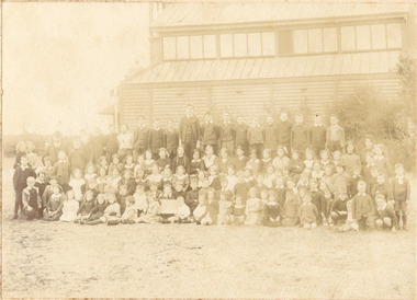
Photograph - Chelsea State School, Mr Rogers with staff and family, 1918
In January 1912, a small school was established at Chelsea, with 65 students, in Hoadley’s Hall, located on Main Road, Chelsea, near the Nepean Highway. Due to its Oriental appearance, the local people called this hall “The Joss House.” Hoadley's Hall was was originally used at the Melbourne Show Grounds by Hoadley's which was moved to Chelsea. The Hall was also used for church services by different religions before they built their own churches. Chelsea State School was built on Argyle Avenue and officially opened on 27 January 1915.Sepia photo of Mr Rogers, his staff and family. Mr Rogers was the first Head teacher of Chelsea State School from 1912 to 1917.chelsea, education, chelsea primary school, school, students, school yard, mr rogers, teachers, chelsea state school -
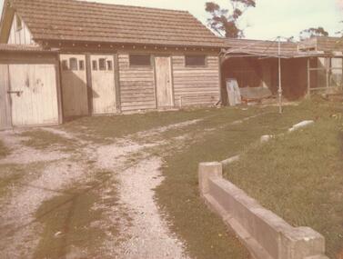 Ringwood and District Historical Society
Photograph, Sheds - Wilsmore's property 90 Maroondah Hwy Ringwood. 1967. (4 photos)
Set of 4 photos taken in relation to the Interim Development Order, May 1963 - EastlandWritten on back of photograph, "9 May 1967. 90 Maroondah Highway. Photograph taken at 11 a.m. by M. Kirkwood in the presence of D.G. Potts". Handwritten on envelope: "Sheds-Wilsmore's Property 90 Maroondah Hway", and on label "Area covered by the Interim Development Order, May 1963 - Eastland." -
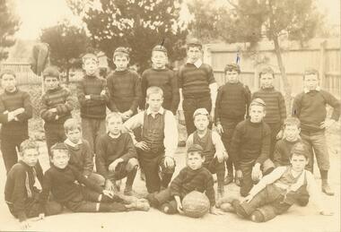 Ringwood and District Historical Society
Photograph, Ringwood State School - Football Team, 1898
Black and white photograph - Football Team, 1898. In original Database entry: Ringwood State School Football Club, c1900. Back row - 1. Geraghty, 2. Hedley Chenhall, 3. Neil O'Meara, 4. --, 5. Bert Hocking, 6. Stan French, 7. Leo Hunt, 8. --, 9 Bert Hardridge. Middle row - 1. Mike Blook, 2. Stan Blood, 3. Harry Mackinley, 4. Alf Hocking, 5. W. Grant, 6. --. Front row - 1. --, 2. --, 3. Eddie Wookey, 4. Cecil Chenhall.Typed below photograph, "The Maroondah Highway Ringwood State School Football team, c1900" and written on backing paper, "Back row - 1. Geraghty, 2. Hedley Chen Hall, 3. Neil O'Meara, 4. Stan French, 5. Bert Hocking". The second copy is dated 1898. -
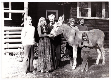 Marysville & District Historical Society
Photograph (Item) - Black and white photograph, Unknown
A black and white photograph of the Lingard Family of Marysville's "Crossways" restaurant. The Crossways was built in the early 1920s and is the oldest building in Marysville. The Crossways historic inn survived the 2009 Black Saturday bushfires thanks to the efforts of its co-owner Greg Cherry and, in the days after the fires, provided a much-needed refuge to the Marysville community and firefighters.A black and white photograph of the Lingard Family of Marysville's "Crossways" restaurant.Part 2 of/ Series Photographer: Colleen Myer/ 185 Maroondah Highway/ Healesville. MINE HOSTS The Lingard Family/ of Marysville's "Crossways"/ restaurant From left: Colin Lawrey (Chef, partner/ and "one of the family", Elizabeth, James/ Jean and David Lingard - with/ "Casey" the donkey, and the Lingards'/ niece Kathy.marysville, victoria, australia, the crossways cabaret, the crossways, crossways, crossways country inn, crossways historic inn, 2009 black saturday bushfires, accommodation, photograph, lingard family, colin lawrey -
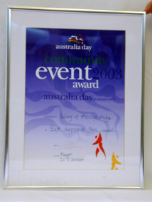 Orbost & District Historical Society
framed certificate, January 2003
This certificate was presented at the East Gippsland Shire Council Australia Day celebrations on 26.1.2003. The veiling of McKillops bridge was a 'Year of the Outback' event. The event was organised by Orbost resident, Sr Helen Barnes RSJ. to show solidarity with rural people. The local community transformed the bridge into "a symbol of communal love and hope", when its sides were draped with hundreds of personal messages. McKillop's Bridge, located high in the Snowy Mountains, is named after George McKillop, a pioneering explorer of the area. The bridge is a vital link for isolated farming communities living beyond the Bonang highway. The Veiling of McKillops Bridge was a significant community event.A large framed certificate. An Australia Day Community Event certificate for January 2003. The frame is silver The certificate has white, green and blue print on a blue background.presented to "Veiling of McKillops Bridge on frame corner AMS by East Gippsland Shie Council signed by Cr P. Bommer (mayor)mckillops-bridge-veiling east-gippsland-shire-council-australia-day -
 City of Moorabbin Historical Society (Operating the Box Cottage Museum)
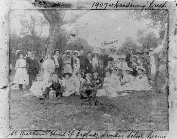
Photograph - St Matthew's Church of England Sunday School Picnic 1907, 1907
The Anglican Cheltenham parish was created in 1865 by excising a portion of the parish of St Andrews Brighton. A small brick church was completed in 1867 to serve a rural community stretching from Brighton South (Moorabbin) to Mordialloc. 1867 St Matthew's Church of England was erected in Cheltenham beside the Nepean Highway near Charman Road. The early settlers established a tennis club, cricket team and social groups. A typical social event was the annual Sunday School Picnic held in 1907 at Dandenong Creek.Young members are mentioned Curly Owen,C,Burnett,A Manett St Matthew's Church of England Cheltenham was erected in 1867 and was integral to the spiritual well being and social life of the early settlers.Black & White photograph of the St Matthew's Church of England Sunday School Picnic 1907Handwritten Curly Owen, C, Burnett, A Manett st. matthew's church of england cheltenham, sunday school picnics, anglican church, st andrew's church brighton, owen curly, burnett c . manett a, horse drawn carts, toll gates brighton, motor cars 1900, steam engines, early settlers, bentleigh, parish of moorabbin, city of moorabbin, county of bourke, moorabbin roads board, shire of moorabbin, henry dendy's special survey 1841, were j.b., bent thomas, o'shannassy john, king richard, charman stephen, highett william, ormond francis, maynard dennis, market gardeners, vineyards, orchards -
 Mt Dandenong & District Historical Society Inc.
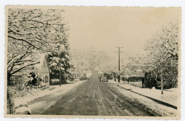
Photograph, Main Street Sassafras in Snow, c1952
The Main Street of Sassafras c1952 showing Mechanics Institute at left under snow. Note the hedge around the area that is now the Village Green. At the time of the photo the land belonged to Eva Shugg where she ran holiday flats called St Annes. Eva Shugg sold her house to Max Dower to extend his nursery in the 1970s and built a new home around the corner on Mountain Highway. At this time she donated part of her remaining land to form a Village Green. Eva Shugg lived to the age of 106 and died in 2007.Black and white photograph with serrated edge showing the Main Street of Sassafras under snow c1952. Mechanics' Institute is on LHS with cars parked outside the site of Sassafras House.On reverse written in pencil 'Main Street, Sassafras"sassafras, snow, mechanics' institute, mechanics' hall, village green, eva shugg, max dower -
 City of Greater Bendigo - Civic Collection
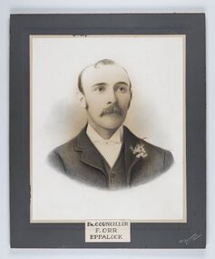
Photograph - Portrait of Councillor Orr, The Yeoman Studios, Ex. Councillor / F. Orr / Eppalock
The district of Strathfieldsaye was proclaimed in 1861 and named a Shire on the 17th September in 1866. It remained a shire until amalgamation in 1994 when it became part of the City of Greater Bendigo. The shire was located 8 km to the south- east of Bendigo and covered an area of 601 square kilometres and extended from the Calder Highway to the Coliban and Campaspe Rivers. The shire's administration centre was in Strathfieldsaye until 1972 when new offices were opened in Kennington. Eppalock Ward is one of three wards in the Greater Bendigo municipality which includes the former Strathfieldsaye Shire. Framed black and white head and shoulder portrait with hand coloured detail. Man with profile slightly to right, walrus moustache, image encircled. Photograph is attached to mount card. Hand written title lower centre.Ex. Councillor / F. Orr / Eppalock / The / Yeoman / Studiosshire of strathfieldsaye, councillor orr -
 Melton City Libraries
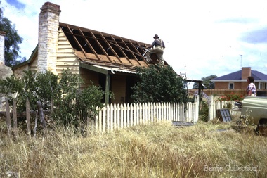
Photograph, Ned Toohey's house, McKenzie Street, 1970
Cottage of Edward Toohey (died 1898) a Shire contractor and road maker. Ned, his son worked with Frederick Myers building many of the bluestone roads in the Shire of Melton. In the background is the brick house built for Martha Myers in 1967. Martha and husband Frederick (born 1877 in Melton) resided in the Myers (Miers) house on Western Highway beside the gully near Reserve road. Frederick lived there for 86 years. The house was built in 1867 by Henri and Ann nee Dowling Myers. Demolished 1968. Martha Myers house was demolished in 2011 to become a car park. Mary and Jack Tolhurst removing roof of Ned Tooheys house (site of Senior Citizens ).local identities, misc. -
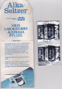 Warrnambool and District Historical Society Inc.
Mixed media - Travellers Aid Bag, Travellers Aid bag & Contents, C 1980
These items were given to clients of the Mid City Motel (probably the one in Ballarat ). The Mid City Motel company was formed in 1963 by a syndicate with the motel in Raglan Parade, Warrnambool. It was later sold with the company liquidated in 1982. The expansion from Warrnambool to Ballarat occurred in 1970 with a building in Doveton Street North, Ballarat. Items such as the sewing kit and shower cap are still given out as promotional material in many motels today. These items are of little importance but are examples of the promotional activities of the motel/tourism scene 30 or so years ago. They may be useful for display.This is a small plastic bag containing a paper sewing kit and a paper folder containing two Alka-Seltser tablets. The sewing kit is red and white and the Alka Seltzer packet is mostly blue. The three items come from the Mid-City Motel and are intended to be kept in a car. Plastic Bag: Mid City Motels, Princes Highway, Warrnambool, 055 62 8026, Doveton Street, Ballarat, 053 31 1222, Travellers Aid Bag for your car with Sewing Kit, Alka Seltzer, Shoe Shine, Shower Cap, Have a Nice Day, Ballarat City Map.warrnambool, mid city motel, tourism -
 Ringwood and District Historical Society
Painting, Winifred Miles, "First Post Office 1883" (Ringwood) - Water colour on paper by Winifred Miles (1884-1944), Undated, later than 1910
"Alexander Colquhoun [Herald art critic 1914-1922 and feature writer for the Age 1926-1941] ... took private students in the first decade of the century, and one of these was Winifred Miles, who after her marriage in 1910 lived the remainder of her life in Ringwood. ... (She) began by doing charcoal studies of animals when she was in Balranald, but in later years moved to oils and then watercolours, travelling around Ringwood to find places to paint by means of a pony-driven governess-cart. She won prizes for paintings in the Royal Melbourne Shows." - Hugh Anderson - Ringwood, Place of Many Eagles [p.217].Painting with cardboard border in glass-fronted frame. Painted from an original black & white photograph, Catalogue Reg No. 1347 recorded as "Ringwood's first Post Office showing first Postmistress, Miss M. Thompson and her mother. 1890". (South side of Main Street (Maroondah Highway), approximately 300 meters west of Ringwood Railway Station). Writing on back of original photograph reads, "Grandma and Auntie Martha Thomson 1890". (Difference in painting date and photograph date indicates years as shown are approximate only). Sticker on back of frame - "Ringwood Framing Gallery, 233 Whitehorse Road Ringwood, Phone 8704930" -
 Bendigo Historical Society Inc.
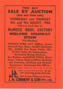
Document - IAN DYETT COLLECTION: AUCTION CATALOGUE - MCNIECE BROS FACTORY - EPSOM
Three orange covered auction catalogues with black printing for a sale on the 8th and 9th August, 1984 at McNiece Bros. Factory Midland Highway, Epsom, Via Bendigo. For sale were Fork Lifts, Guillotine, Pan Break Folder, Air Compressors, Horizontal Boring Machine, Arc Welders, Machine Tools, Stores Assort. Valves, Modern Office Machines and Furniture, Drafting and General Equipment and Aluminium Site Office. Some lots in the catalogue are underlined. J. H. Curnow & Son Pty. Ltd. Were the auctioneers.business, auctioneers, j h curnow & son pty ltd, ian dyett collection - auction catalogue - mcniece bros factory - epsom, j h curnow & son pty ltd, mr bill doxford, f c dyett, i m dyett, n f dyett, bolton bros pty ltd print -
 Whitehorse Historical Society Inc.
Article, Rezoning plan riles retailers, 1992
Despite widespread disapproval by traders and residents, Nunawading Council still plans put its draft structure plan for Vermont South Activity Centre on public display.Despite widespread disapproval by traders and residents, Nunawading Council still plans put its draft structure plan for Vermont South Activity Centre on public display. Council owned land on Burwood Highway is earmarked for rezoning to restricted business zone. The draft has designated the area for a mix of office and retail development. it is not intended to duplicate retail services which already exist. Manager of Vermont South Shopping Centre Patricia Wilson says the traders object to any amount of extra retail development.Despite widespread disapproval by traders and residents, Nunawading Council still plans put its draft structure plan for Vermont South Activity Centre on public display.shops, city of nunawading, wilson, patricia, vermont south shopping centre, burwood highway, vermont south, nos 473-493 -
City of Kingston
Photograph - Colour, c. 1993
Patterson Lakes is a suburb in the City of Kingston that is built one kilometre upstream of the mouth of the Patterson River. The area is bordered by the Patterson River and Eel Race Drain which enters the Kananook Creek. The suburb consists predominantly of newer housing developments and the tidal canal system of the development joins Port Phillip Bay.Patterson Lakes and the Kananook Creek were previously part of the extensive Carrum Carrum Swamp. The area was once a source of fish and eels for the Mayone-Bulluk clan of the Bunurong people. Over time the area was drained and in 1973 investigations commenced into the development of a unique residential area that would be built adjacent to canals and waterways. It was originally proposed to be known as "Gladesville". The development would give the suburb's homeowners access to Port Phillip Bay "from their back door". Circa 1974, the area was rezoned from rural to residential and named Patterson Lakes. Development has been continuous since the 1970s with construction of residential housing, schools, shopping centres, marinas, a hotel and library.Laminated colour aerial photograph of the Carrum and Patterson Lakes region within City of Kingston. This 1993 image includes Patterson River Secondary College, Roy Dore Reserve, Kananook Creek and Nepean Highway. The railway line can be seen as it veers inland from Eel Race Road, Seaford. The section of Palm Beach Drive, Curlew Point Drive, Snapper Point Drive, Clipper Island and Myola Street in Patterson Lakes appears to be a recent development with many spare blocks and new houses under construction.patterson lakes, seaford, kananook creek, carrum carrum swamp, canals and waterways -
 Ringwood and District Historical Society
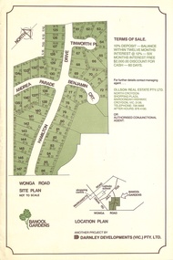
Flyer, Land Sale Advertisement - Banool Gardens Subdivision, Ringwood, Vic. c.1985
Double-sided advertisement for Banool Gardens subdivision with site plan, location plan, terms of sale, and summary of homesite features and local services & facilities. Subdivision includes Wonga Road, Hamilton Drive, Tinworth Place, Andrea Parade and Benjamin Court, Ringwood North. Managing agent - Ollson Real Estate Pty. Ltd., North Croydon Shopping Plaza, Maroondah Highway. Croydon, Vic. 3136. Telephone 726 9988 After Hours 876 4190. Project by Darnley Developments (Vic.) Pty. Ltd. Accompanying handwritten notation by Richard Carter R.E.S.I. - "Part of original Banool property (Mahon, sold to Stallman, sold to McMahon, sold to Len Macley etc etc). Hamilton Drive named after Lynn Hamilton McMahon, Tinworth Place after his son-in-law, David Tinworth". -
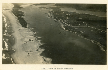 Lakes Entrance Historical Society
Photograph - Lakes Entrance, 1923c
Two copies 16.5 x 25.5 very darkBlack and white photograph showing early aerial view of township of Lakes Entrance, photo shows highway going along Myer Street and along Roadknight Street, no shops in Myer Street appears to be no foot bridge, therefore taken prior to 1937, sparce vegetation on foreground dunes, four barriers built on dunes to stop erosion through sand, two masted sailing boat in lake. Bullock Island in distance appears very small, Snake Island of Rigby Island in centre distance. Lakes Entrance VictoriaAerial View of Lakes Entrancewaterways, coast, aerial photograph, islands, township -
 Melbourne Tram Museum
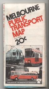
Map, Ministry of Transport, "Melbourne Public Transport Map", c1977
Fold out map (27 sections 9 across x 3 deep), coloured of Melbourne's Tram and Bus routes, route numbers, rail lines, detailed for the central part of Melbourne and insert section for Frankston. On rear description of routes, private bus routes and map of Melbourne metro lines. Has contact details for bookings and lost property etc. Priced 20c Dated 1977, says No. 6 on bottom of rear cover. Note shows route 59 being cut back to the highway.trams, tramways, melbourne, map, tram & bus services, railways, mmtb, minister for transport -
 Melbourne Tram Museum
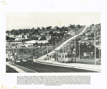
Photograph - Illustration/s, c1979
Illustration - black and white - possibly cut from a calendar sheet - of Burwood Highway, looking east just west of the Elgar Road intersection. Shows the relatively new track and Z25 inbound to Spencer St. Has a golden fleece service station on the left hand side. Shows the road arrangements at the time. Caption to illustration notes first new extension since 1956, opening date, reserved track and that Z class trams are used on it. One of the 1969 Metropolitan Transport Committee recommendations. Two copies held.trams, tramways, burwood highway, burwood, track construction, mmtb, z class, tram 25 -
 Ringwood and District Historical Society
Photograph, Kenneth Marshall, Ringwood Lake around 1960, path on west side, circa 1960
Framed silver gelatin printNotation on back - "Ken Marshall, Jeweller, Maroondah Highway Ringwood took this photo. It was displayed in his shop window when I bought it. The shop was next door to Pratt, the butcher, and Ron Dickson, fruiterer, just prior to the Eastland development - [from] Gloria Welch, 23 Campbell St. Ringwood East."