Showing 11608 items matching "surveyor-general"
-
 Bendigo Historical Society Inc.
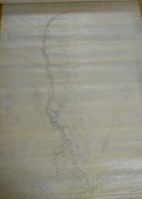
Map - WESTON, 21/10/1876
Map: Re-Survey of part of the parish of Weston, County of Rodney. Parish plan (number 309 in map cupboard 1)Murray and Hargreave, Authorised surveyorsmap, rodney, parish plan, parish of weston, murray and hargreave -
 Bendigo Historical Society Inc.
Map - PLAN OF BENDIGO CREEK, 12th March 1873
Map: Hand drafted plan of the Bendigo Creek, covering from Scott St. White Hills to Alder St. Kangaroo Flat. Scale 2 chains to 1 inchGeorge R------- ? City Surveyormap, bendigo, bendigo creek -
 Warrnambool and District Historical Society Inc.
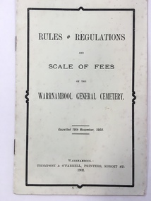
Booklet, Thompson & O'Farrell, Rules & Regulations scale of fees Cemetary, 1902 (original edition)
This booklet gives the Rules and Regulations and the Scale of Fees for the Warrnambool General Cemetery as from 1902. The booklet rescinded the Rules and Regulations of 1855 and amongst the 1902 Rules it is noted that no catacombs or wooden structures were allowed by the Trustees. It was also noted that no child under ten was permitted into the cemetery grounds unless under adult supervision. The charge for an adult burial was £1 and ten shillings for a child under ten. The Warrnambool Cemetery is in Otway Road, Warrnambool and was first gazetted in 1853 with Mr Whittet as the first Sexton. This booklet is of considerable interest because it gives the Rules and Regulations and the Scale of Charges of the Warrnambool General Cemetery as laid down in 1902. The Trustees at the time were William Ardlie, a prominent Warrnambool lawyer, Samuel Nettleton, a well-known Warrnambool shopkeeper and J.H.Allan, a member of a pioneering family in the Warrnambool district. This is a small booklet containing the Rules and Regulations of the Warrnambool General Cemetery. It contains four double-sided pages with printed material on all of the pages. The cover is pale yellow and the printing on the front cover has a black edging. There is some silverfish damage on the page edges. The pages were stapled together but the staples have been removed (the use of staples suggests that this booklet is perhaps a reprint at a later date)Front Cover: ‘Rules and Regulations and Scale of Fees of the Warrnambool General Cemetery, Gazetted 19th November 1902, Warrnambool, Thompson and O’Farrell, Printers, Koroit St. 1902’.warrnambool general cemetery -
 Warrnambool and District Historical Society Inc.
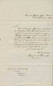
000851.1; Letter 000851.2:Copy of Baptismal entry, Augustus Bostock birth details, 000851.1. 1884. 000851.2 late 20th century
Augustus Bostock was the 9th child of Robert & Rachael Bostock of Vaucluse Epping Forest, Van Diemen’s Land. He was only 4 years old when his mother died. He was inspired by his father to seek his fortune in the Western District of Victoria. He arrived around 1850. He married Margaret Aitkin in July 1865. Augustus owned several properties in the district and leased others. He sat on the court of Warrnambool, Mortlake or Hexham as required. He resided at Marramook in Hawkesdale and later moved to Vaucluse in Hopetoun Road Warrnambool, where he died in 1920 at the age of 87. He was involved in many aspects of life in the Western District, racing, cricket, and social activities to name a few. These two documents relate to the registration of Augustus Bostock’s birth 14/01/1833. This is one of a number of documents which relate to the Bostock family who were one of the most important pioneering families of the Western District. They owned and leased various properties around Warrnambool and were involved in many aspects of social and business life. This is a personal document which confirms details of the birth of Augustus Bostock.000851.1. Handwritten letter from General Register Office Hobart. Foolscap sized lined white paper with writing in black ink. 000851.2 Copy of baptisms in the parish of Campbelltown 1835. Handwritten entries in chart form with handwritten entries. 000851.1 General Register Office Hobart. 000851.2 Parish of Campbelltown in the county of Cornwall 1835. warrnambool, augustus bostock, robert and rachael bostock, campbelltown, hobart 1835. -
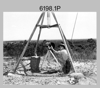
 Bendigo Military Museum
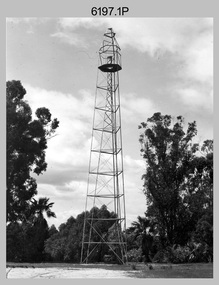
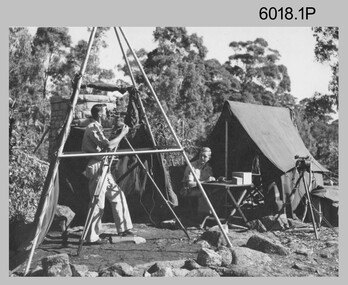
Photograph - Royal Australian Survey Corps Survey Observation Towers, c1950s
This is a set of seven photographs of Royal Australian Survey Corps surveyors setting up observation towers in the field and undertaking survey observations during mapping and geodetic control operations. c1950s. Survey observation towers were used mainly to take angular measurements in flat or heavily forested terrain, where height was necessary to achieve observer’s line-of-sight between field survey station. The Bilby Tower seen in photo .5P was erected to a height of 75 feet (23m) above ground level. The use of the Bilby Tower in Topographic Squadron’s field survey operations from 1955 to 1966 is described in page 54 of Valerie Lovejoy’s book 'Mapmakers of Fortuna – A history of the Army Survey Regiment’ ISBN: 0-646-42120-4. CAPT George Ricketts’ period of service was from 1942 to 1976 reaching the rank of LTCOL. It is noted in page 35 of Valerie Lovejoy’s book that then SGT Ricketts hand lettering skills came to the fore from his contribution to the draughting of one of the Japan’s Instruments of Surrender in 1945.This is a set of seven photographs of Royal Australian Survey Corps surveyors setting up observation towers in the field and undertaking survey observations during mapping and geodetic control operations. c1950s. The photographs were printed on photographic paper and are part of the Army Survey Regiment’s Collection. The photographs were scanned at 300 dpi. .1) - Photo, black & white, c1950s, ‘Bilby’ survey observation tower. .2) - Photo, black & white, c1950s, CAPT George Ricketts climbing ‘Bilby’ survey observation tower. .3) - Photo, black & white, c1950s, geodetic survey equipment on ‘Bilby’ survey observation tower. .4) - Photo, black & white, c1950s, two unidentified field surveyors on ‘Bilby’ survey observation tower. .5) - Photo, black & white, c1950s, two unidentified field surveyors, with CAPT Ricketts climbing ‘Bilby’ survey observation tower. .6) - Photo, black & white, c1950s, two unidentified field surveyors undertaking observations on survey observation tower. .7) - Photo, black & white, c1950, two unidentified field surveyors erecting or dismantling a survey observation tower..1P with paper tag annotated ‘Bilby Tower’ .4P on back – ‘Bilby Tower’. .5P on back – ‘Survey Observing Tower. Observing tower used for angular measurement in flat country. 75’ high – CAPT Ricketts climbing. .6P, .7P on back. ‘1960s?’royal australian survey corps, rasvy, army survey regiment, army svy regt, fortuna, asr, surveying -
 Ringwood RSL Sub-Branch
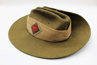
Headgear Slouch Hat, Unknown
Hat from 2/2nd Aust General Hospital WW2puggaree with colour patch 2/2nd AGH ww2 2/2nd australian general hospital ww2, -
 Bendigo Military Museum
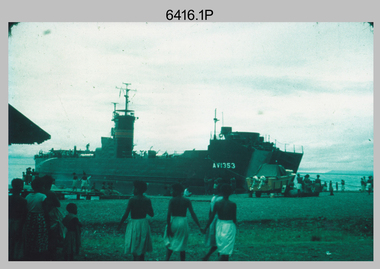
Photograph - Royal Australian Survey Corps Surveyors in the Field – PNG, 1962
This is a set of four photographs of surveyors and support staff in the field undertaking duties in Dogera, Milne Bay Province and Kerema, Gulf Province of PNG in 1962. The surveyors were employed in the establishment of mapping and geodetic control. In this era surveyors used theodolites to observe horizontal and vertical angles and tellurometers to measure base line distances between survey stations. From 1957 helicopter transport of survey parties revolutionised transport in remote areas.This is a set of four photographs of surveyors and support staff in the field undertaking duties in PNG in 1962. The photographs were printed on photographic paper and are part of the Army Survey Regiment’s Collection. The photographs were scanned at 300 dpi. .1) - Photo, colour, 1962. Unloading survey operation stores from a Landing Ship Medium (LSM) at Dogera, Milne Bay Province, PNG. .2) & .3) - Photo, colour, 1962. Hired civilian helicopter Bell 47G-2 helicopters operating at at Dogera, Milne Bay Province, PNG. .4) - Photo, colour, 1962. Survey party at survey station located near Kerema, Gulf Province southern PNG. L to R: Dave Owens, Keith Broadbent, with local villagers in background..1P to .4P annotated on back – personnel names, the year and the location. royal australian survey corps, rasvy, army survey regiment, asr, army svy regt, fortuna, surveying -
 City of Moorabbin Historical Society (Operating the Box Cottage Museum)
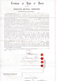
Certificate - Document, Certificate of Burial 1890, c1880
James Jones was the son of Philip Jones, a Chairmaker, and Ann Jones who settled in East Brighton after the sale of land c1852 in the area of the Henry Dendy Special Survey of 1841. Mary Ann Moore was the daughter of Thomas Moore, a Gardener, and Sarah Harris who also settled in Brighton c1852. James and Mary Ann Jones settled and raised their family in East Brighton now Bentleigh. Mr John Herron resided at 4 Vickery St Bentleigh until 1989. Sadly Martha Jones born 1888 died in 1890 and James Jones had to purchase this plot at Brighton General Cemetery for her burial. A further 2 children were interred in 1893 and 1900 then Mary Ann in 1903 and James in 1940 James Jones and Mary Ann Moore were born in Brighton c1857 and c 1859 into pioneer market gardener families in the area of the Dendy Special Survey of 1841. They married in 1883 and raised their family in East Brighton, now Bentleigh. Sadly infectious diseases took the lives of many infants throughout the Colony of Victoria due to the poor state of water supply and sewerage disposal and locally the swamps of the Elster Creek were a constant breeding ground.An original paper Certificate of Right of Burial in The Brighton General Cemetery signed and dated by the Trustees of the Cemetery upon the application of James Jones of East Brighton, Victoria, 22nd April 1890. A plot , Register No. 2844, of 4 feet in width and 8 feet in depth in the Wesleyan Section, No. 199, compartment G in the Brighton General Cemetery. would be supplied upon payment of Two Pounds two shillings and receipt of same is acknowledged. Certificate of Right of Burial / IN THE / BRIGHTON GENERAL CEMETERY. Application of Mr James Jones of East Brighton for a plot to be supplied upon payment of Two Pounds and 2 Shillings and receipt of same acknowledged. Signed by the Trustees of the Cemetery, (4 signatures) in presence of S. Simmonds, dated twenty- second April 1890 Reverse side Dated 22nd April 1890 / Certificate of Right of Burial / IN THE / BRIGHTON GENERAL CEMETERY/ Mr James Jones ( hand written) / DENOMINATION Wesleyan / Compartment G / No. 199 Hand written on right side 3454 (signed) S Simmonds / 4797 (signed) S Simmonds / 36897 20/ 11 / 40 melbourne, brighton, moorabbin, water supply, pioneers, bentleigh, dendy henry, market gardeners, early settlers, jones mary ann, wesleyan church, jones james, vaccination, typhoid, dendys special survey 1841, infectious diseases, elster creek, jones martha, brighton general cemetery -
Clunes Museum
Map - SURVEYERS MAP OF CLUNES, J. FINNIE, 1883
A SURVEYORS MAP OF CLUNES. GEOLOGICALLY AND TOPOGRAPHICALLY SURVEYED BY R.A.F. MURRAY.LITHOGRAPHED BY R. SHEPHERD AND PRINTED BY J. FINNIE MINING DEPARTMENT, MELBOURNE,1883document, surveyers map of clunes, map of clunes -
 Whitehorse Historical Society Inc.
Photograph - Photograph Album, Tanglewood
The album was given to the owner who was selling the property by the Estate Agent.Photo album with photos of the property for sale..Doolan and Goodchild Surveyorstanglewood, property for sale, blackburn, the avenue -
 Uniting Church Archives - Synod of Victoria
Work on paper - Methodist Order of Knights, Page's Degree symbol
The number seven enclosed in an equilateral triangle was the General Mark of the Order. The number seven is the perfect number used in scripture. The Methodist Order of Knights was the official youth organisation of the Methodist Church of Australasia. It originated in Hurstville, NSW, on the 4th October 1914 by the then Mr and later Rev Alex Bray. Alex Bray was a Sunday School teacher and spoke to his class of the Knights of the Round Table. In 1917 the Order of Knights was officially recognised by the Sunday School Dept of the NSW Methodist Conference. Courts spread thoroughout Australia. In 1927 the High Court of NSW called for designs for a badge and in 1929 the General Conference of the Methodist Church of Australasia recognised the Order as an approved Organisation. In 1938 the Senior Section was organised into Degrees of Sincerity, Service and Sacrifice; the Junior Section into Pages' Degree with advancement to Esquire. In 1954 the Junior Section was reorganised into two groups: Pages 8 to 11 years and Esquires 12 to 15 years. The Knight's Motto: "Live Pure, Speak True, Right Wrong, Follow Christ the King, else wherefore born?" Courts of the Order: General Conference Department of the Christian Education - General Court - Provincial High Court - District Court - Local Court - Senior Court - Intermediate Court - Junior Court . Regalia: All members of the Intermediate and Senior Courts wore regalia consisting of a cloth shield superimposed by a cross of light and dark blue ribbons, and supported by a cloth collar. Esquire and Degree of Sincerity regalia: White collar and white shield. Degree of Service regalia: Green collar and shield. Degree of Sacrifice: Scarlet collar and shield. District Court regalia: Blue collar and gold shield. High Court regalia: Gold collar and purple sheild. General Court regalia: Purple collar and shield. Officers of the local courts wore their symbols as part of their regalia. Square cardboard and black ink general mark of the order symbols.On the back of MOK214.2: Sticker with the words "FRAMED BY BALLARAT GLASS COY. Glass and Glazing, etc. 54 HUMFFRAY ST. NTH. BALLARAT"methodist order of knights -
 Stawell Historical Society Inc
Photograph, Stawell Geodetic Survey at work. c1940's
Taken while surveying western half of Victoria to South Australian Border.Theodolite in foreground. Behind Surveyor in hat, shirt, long pants. Directly behind is Survey technician in hat, Tee shirt and shorts. Surveyor unknown. Assistant Alan Edward Tangey of Stawell. Reverse 4 2 2 6 -
 Bacchus Marsh & District Historical Society
Map, Allotments in the Village of Rowsley, Parish of Gorrocburkghap, County of Grant c.1856
Rowsley is a locality 11 kilometers south-west of Bacchus Marsh. The date of this map is uncertain. A very similar map held by the State Library of Victoria (SLV) contains slightly more information than this copy and is dated as an 1856 map. SLV reference: 'Allotments in the Village of Rowsley, Parish of Gorrocburkghap, County of Grant', by T. Nixon, Assistant Surveyor, May 1856 ; Surveyor General’s Office, July 18 1856 (lithographed by R. Meikle). (1856). Melbourne: Surveyor General’s Office. MAPS 820 BJE 1837- ROWSLEY 1856. A single page paper map. A cadastral map of the Village of Rowsley in Victoria, showing numbered land allotments. 57 allotments are shown on the map and some areas set aside as reserves. Allotments 8, and 10-16 are outlined in red ink and allotment 9 has a cross in red ink on it. The map is pasted into a bound volume containing 76 maps or plans in total. High resolution digital image stored on BMDHS computer network. rowsley victoria history, rowsley victoria maps -
 Bendigo Historical Society Inc.
Photograph - HARGREAVES STREET BENDIGO
Copy of black and white photograph. Image taken from Hargreaves Street, looking towards the Jewish Synagogue. Warren's Timber yard in foreground. Copy of research on site of synagogue, two letters written in 1855, to the Surveyor General Melbourne and one to G. Stanker (?) (name indecipherable)bendigo, streetscape, hargreaves street, jewish, synagogue, warren's timber yard -
 Dandenong/Cranbourne RSL Sub Branch
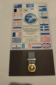
Work on paper - Korean War Medal, Circa 1950
Korean Veterans Association of Australia Inc. Donated to Dandenong RSL by Major General J C Hughes AO DSO MC.Korean Veterans Association Patron: Major General J C Hughes AO, DSO, MC. The Korean War 1950 - 1953. Bordered by the Flags of 21 Nations. -
Hume City Civic Collection
Map, Sunbury Township 1857
This is a reprint of a 1857 map of the township of Sunbury in the County of Bourke produced by the Public Records Office by courtesy of the Surveyor General in 1978.This is a reprint of a 1857 map of the township of Sunbury.sunbury, shire of bulla, sunbury township, 1850s -
 8th/13th Victorian Mounted Rifles Regimental Collection
Photograph - GG McKell in Albury
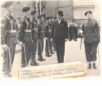
Black and white photograph of the Governor General Sir William McKell inspecting an honour guard drawn from 8/13 Victorian Mounted Rifles at Albury c. 1950Albury / Governor General Sir William McKell / Lt I McKay, Sgt R Braddy, L/Cpl M Youngguard, vmr, mckell, govornor general, albury, military -
 Bendigo Military Museum
Photograph - Royal Australian Survey Corps Electronic Distance Measuring Equipment Demonstration, c1960s
This is a set of five photographs of CAPT James ‘Jim’ Leslie Stedman in the field demonstrating the setup of prisms used as electric distance measurement (EDM) receiver reflectors for tellurometer equipment and the sighting of a large surveyor’s light. This equipment was deployed in establishing mapping and geodetic control operations. The photos were most likely taken in the late 1950s or early 1960s. The tellurometers of this era were man-portable systems that improved geodetic survey efficiencies for rapid network extension and densification replacing triangulation with EDM and theodolite traverse sometimes using Bilby Towers to extend line lengths. Jim Stedman later reached the rank of Colonel, was Director of Military Survey from 1975 to 1978 and was appointed as Colonel Commandant (honorary appointment, Retd) of the Royal Australian Survey Corps from 1978 to 1983. Jim Stedman is demonstrating EDM equipment. See item 6180.16P, photos .14) to .16) for more information and photos of Jim Stedman’s EDM demonstration. This is a set of five photographs of a surveyor in the field demonstrating electric distance measurement (EDM) equipment. c1950s – 1960s. The photographs were printed on photographic paper and are part of the Army Survey Regiment’s Collection. The photographs were scanned at 300 dpi. .1) to .2) - Photo, black & white, c1960s, CAPT Jim Stedman demonstrating the sighting of a large surveyor’s light. .3) to .5) – Photo, black & white, c1960s, CAPT Jim Stedman demonstrating EDM prism equipment. .1P to .5P on back – CAPT Stedman EDM Eqpt.royal australian survey corps, rasvy, army survey regiment, army svy regt, fortuna, asr, surveying -
 Melbourne Legacy
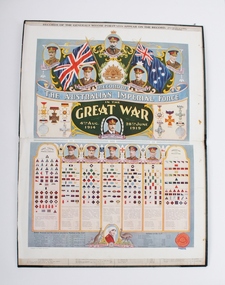
Book, AUSTRALIA'S RECORD, c.1920
Pictorial and written record of Australian generals in World War 1. From Trove it is 'Record of the Australian Imperial Force in the Great War 4th August 1914 - 28th June 1919' by J.W. Sanders. Published in approximate 1920. More details to be added. TBA and check locationShows British and Foreign honours bestowed on generals, and commands held in the Australian Army during World War 1.A bound green ledger of Australia's generals in the first world war.Title printed in capital letters and underlined with an arc, gold lettering. Badge of the Rising Sun and inscription underneath badge (AUSTRALIAN COMMONWEALTH MILITARY FORCES) printed in gold lettering.world war one, australian imperial force, history -
Whitehorse Historical Society Inc.
Mixed media - Audio Cassette, Lighthouses - Doug Watkins, 1/06/2001
Tape of talk by Doug Watkins to Nunawading Historical Society on Lighthouses at General Meeting on 2 June 2001.Tape of talk by Doug Watkins to Nunawading Historical Society on Lighthouses at General Meeting on 2 June 2001.watkins, doug, lighthouses -
Eltham District Historical Society Inc
Folder, R. Brazill, 1860s
Folder of information on R Brazill, mining surveyor, Caledonia Diggings, 1860sr brazill -
 Bendigo Historical Society Inc.
Book - REPORT OF THE MINING SURVEYORS AND REGISTRARS, 31ST. DECEMBER 1881, 1881
REPORT OF THE MINING SURVEYORS AND REGISTRARS, 31st. December 1881. 44 pagesVic. Govt.gold mining, miners' safety cage, mining surveyors and registrars rep, gold mining, bendigo, goldfields, mining surveyor, mining registrar's reports -
 Bendigo Historical Society Inc.
Book - REPORT OF THE MINING SURVEYORS AND REGISTRARS, 30TH. JUNE 1881, 1881
REPORT OF THE MINING SURVEYORS AND REGISTRARS, 30TH. JUNE 1881. 40 pagesVic. Govt.gold mining, miners' safety cage, mining surveyors and registrars rep, bendigo, gold mining, goldfields, registrars, mining surveyors report -
 Bendigo Historical Society Inc.
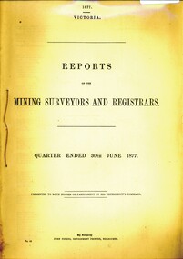
Book - REPORT OF THE MINING SURVEYORS AND REGISTRARS 30TH. JUNE 1877, 1877
Report of the mining surveyors and registrars, quarter ended 30th June 1877.gold mining, miners' safety cage, registrars and surveyors report, gold, gold mining, registrars, surveyors -
 Bendigo Historical Society Inc.
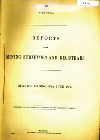
Book - REPORTS OF THE MINING SURVEYORS AND REGISTRARS, 1872
REPORTS OF THE MINING SURVEYORS AND REGISTRARS. Quarter ending 30th June 1872.gold mining, miners' safety cage, registrars report, gold, gold mining, surveyors, registrars report. -
 Halls Gap & Grampians Historical Society
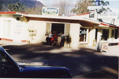
Photograph - Coloured, C 1960
This is a photo of Thomson's General Store; a second general store built in Halls Gap by Jack and Clarrie Thomson . They incorporated a cafe with their business.Photo shows five children are standing in front of the window of a general store. There is a dark coloured "E" series Holden car parked in the left front foreground.buildings, shops -
 Chelsea & District Historical Society Inc
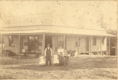
Photograph - Carrum General Store, Ramsays, 1900
Sepia photo of Carrum General Stores, with wares on display on the verandah. The shopkeeper, his wife and three young girls are standing in front of the store. The store was situated opposite the Carrum Station.CARRUM GENERAL STORE W. RAMSAY DRAPER&GROCER ETC COOL SUMMER DRINKS HOT - WATER SUPPLIED IRON BOOTSgeneral store, carrum general store, carrum, shop -
 Bendigo Military Museum
Photograph - Royal Australian Survey Corps Surveyors in the Field, Army Survey Regiment, 1950s to 1970s
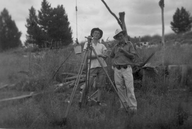
These three photographs were most likely taken from the 1950s to the 1970s. The RASvy surveyor in each photograph was taking angular measurements with the observer recording their readings on a booking form. They were probably employed in establishing mapping and geodetic control operations or the surveyors may have been in training. Photo .1P was possibly taken at Mount Alexander in Central Victoria, a location close to Bendigo, as the stone cairn in the background of the photo appears to be identical to the cairn presently located on top of the mountain. Personnel and location have been confirmed on another photo in the collection with annotation. These three photographs are of surveyors in the field undertaking observations using theodolites. The photographs were printed on photographic paper and are part of the Army Survey Regiment’s Collection. The photographs were scanned at 300 dpi. .1) - Photo, black & white, c1950s. Unidentified personnel undertaking observations with a Tavistock geodetic theodolite. .2) – Photo, colour, mounted on card, c1960s. Unidentified personnel undertaking observations with a Kern DKM2 theodolite. .3) - Photo, colour, c1970s. Unidentified personnel undertaking observations with a theodolite..1 – not annotated .2 –annotated on front “Kern DKM2, TOPO 10” royal australian survey corps, rasvy, army survey regiment, army svy regt, fortuna, asr, surveying -
 Diamond Valley Vietnam Veterans Sub-Branch
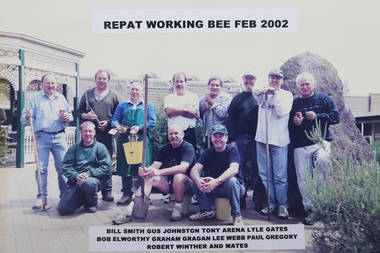
Photograph - Repat Hospital, c2002
DViet Working Party at Repatriation and General Hospital - evidence of the close ties between the two parties.Photo confirms that the Diamond Valey Sub Branch and the Repatriation and General Hospital have worked cooperatively for many years.Rectangular coloured photograph showing sub branch members and friends working bee, Repatriation and General Hospital, 2002.A Listing of participants at the working bee.vietnam, vietnam war, diamond valley vietnam veterans sub branch, repatriation hospital -
 Federation University Historical Collection
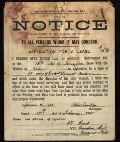
Document, Notice, 18/02/1908
Form of Notice regarding an application for a lease to be posted on the land by the surveyor. The land in question is 30 acres at Ballarat North and the applicant was William Arnell of 108 Brougham Street, Ballarat North, and the surveyor was Robert Davidson.land lease, robert davidson, william arnell, ballarat north