Showing 4563 items matching "the avenue"
-
 Friends of Ballarat Botanical Gardens History Group
Work on paper - Lucas Booklet, 1921. Souvenir, Ballarat Arch of Victory and Avenue of Honour, 7/2009
Details are given of the establishment of the Avenue of Honour and the Arch of Victory, the opening of these by H.R.H. Prince of Wales 2/6/1920 and the making of a pair of yellow silk pyjamas, by the Lucas girls for the Prince, latterly, Duke of Windsor. The Arch of Victory and Avenue of Honour are important landmarks in Ballarat of which citizens of Ballarat are justly proud.2 pages of typed notes. p.1, quotations from 2 references are cited at the bottom of p.1 and on p.2, there is a poem entitled "The Royal Pyjamas."None.john garner, doctor john garner, lucas girls, arch of victory, avenue of honour, h.r.h. prince of wales, duke of windsor., r.selkirk, john garner collection, gardens, ballarat -
 Bendigo Historical Society Inc.
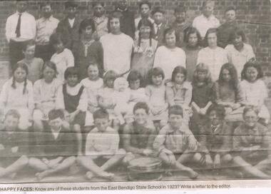
Newspaper - JENNY FOLEY COLLECTION: HAPPY FACES
East Bendigo State School, no.3893, operated in Strickland Road 1916-1998. In 1920 an Avenue of Honour was planted by the students, on the approach to the school. Although the trees are no longer there, the name plates are preserved at the Bendigo RSL.Bendigo Advertiser ''The way we were'' from 2003. Happy faces: know any of these students from the East Bendigo Sate School in 1923? The clip is in a folder.newspaper, bendigo advertiser, the way we were -
 Kew Historical Society Inc
Plan - Subdivision Plan, Myrtle Park Estate, City of Camberwell, 1916
The Kew Historical Society collection includes almost 100 subdivision plans pertaining to suburbs of the City of Melbourne. Most of these are of Kew, Kew East or Studley Park, although a smaller number are plans of Camberwell, Deepdene, Balwyn and Hawthorn. It is believed that the majority of the plans were gifted to the Society by persons connected with the real estate firm - J. R. Mathers and McMillan, 136 Cotham Road, Kew. The Plans in the collection are rarely in pristine form, being working plans on which the agent would write notes and record lots sold and the prices of these. The subdivision plans are historically significant examples of the growth of urban Melbourne from the beginning of the 20th Century up until the 1980s. A number of the plans are double-sided and often include a photograph on the reverse. A number of the latter are by noted photographers such as J.E. Barnes.The ‘Myrtle Park Estate’ was a subdivision bounded by Victoria Road (now Lansdowne Street), Buchanan Avenue and Dight Avenue. Other streets that were created by the subdivision included Eurolie Street, Boorahman Street and Moody Street (now Sylvan Street). The Estate took its name from Myrtle Park (later changed to Macleay Park), which had been created in 1923 by Camberwell Council. The Park adjoined the southeast corner of the new subdivision. The Estate included 74 regular allotments characterised by narrow frontages and long blocks. Confusion may have greeted prospective purchasers as the Estate was advertised in the daily newspapers as being in East Kew, rather than in Camberwell, where it was at that stage located.subdivision plans - balwyn, myrtle park estate - camberwell [surrey hills] -
 Southern Sherbrooke Historical Society Inc.
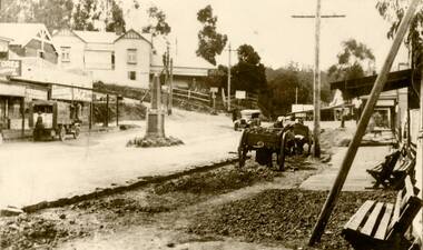
Photograph, Main Road, Belgrave
Early photo of the Main St, Belgrave. Coffee Palace is left of centre on side of Terrys Avenue. Cenotaph is in centre of road in front of shops, where Morson Court now stands. Men with horse and carts appear to be working on the road or footpath. Site of U. S. Motors visible on right hand side. -
 Kew Historical Society Inc
Photograph - Yarra Valley Floods: Kew East, 1916
Flooding of the Yarra Valley, including that section of the Yarra bordering Kew and Kew East in the north and west of the municipality, was a regular occurrence. Extreme flood events of the Yarra River are recorded to have occurred in 1891, 1901, 1916, 1923 and 1934. The Municipality of Kew's response to these floods was to enact planning decisions restricting residential development in flood prone areas following the floods of 1916, 1921 and 1934. While floods continued after the development of the Upper Yarra Reservoir (construction 1948-57), the regularity and extent of these inundations diminished. During the nineteenth century, the land abutting the south side of the Yarra in Kew was devoted to dairy farming. In the twentieth century, before and after the construction of the Eastern Freeway, much of this low-lying area was used as golf courses and public parks.One of a collection of photographs of flooding in the Kew section of the Yarra Valley which are in important research resource for the location and extent of flooding in the first half of the twentieth century. Flooding of the Yarra Valley at East Kew in 1916. The view is taken from a street (maybe Birdwood Avenue) intersecting with Kilby Road looking northeast across the flood waters to Ivanhoe and Heidelberg. The extensive flooded area shown in the photograph would have included remnant dairy farms and the Kew Golf Club. Verso: "Floods / Yarra River / East Kew / Kilby Road / 1917? / 87"yarra river, yarra valley, floods -- kew, kilby road -- kew (vic.), kew golf club -
Glen Eira Historical Society
Document - O’Neill College, Nagle Avenue, 2, Elsternwick
Photocopy of the Caulfield conservation of 1A Nagle Avenue, Elsternwick, formerly O’Neill College, now Leibler Yavneh College; by Andrew Ward; March 1995. Provides a brief description, history and statement of architectural significance of the buildings.o’ neill college, ward andrew, secondary schools, primary schools, independent schools, star of the sea, presentation sisters, liebler yavneh college, schreiber r. a., teachers, nagle avenue, catholic schools, nagle avenue, elsternwick, colleges, architectural features, architectural styles, religions structures and establishments, chapels, synagogues, jewish religion, caulfield, elizabethan revival style, brick, towers, chimneys, verandahs, tiles, architects, o'neill college, o'neill sarah -
Glen Eira Historical Society
Document - Maysbury, Maysbury Avenue, 1, Elsterwick
A Caulfield Conservation study report by Andrew Ward dated August 1994 on 1 Maysbury Avenue, Elsternwick including a description, history and statement of the building’s significance. Includes references and a black and white photocopy of a photograph of the exteriorward andrew, maysbury avenue, maysbury, maysbury flats, elsternwick, caulfield conservation study, architectural features, italianate style, mansions, verandahs, morris john, sandham street, orrong road, glenhuntly road, watson alexander, victorian style, bedwell e.p -
 Greensborough Historical Society
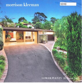
Advertising Leaflet, 26 Byron Avenue Lower Plenty, 27/06/2018
26 Byron Avenue Lower Plenty. 4 bedroom house. Sold 27/06/2018 for $1,290,000. Previous sales: June 2006 for $336,000, February 1994 for $145,000 and January 1989 for $160,000. Built 1969.Real Estate advertising leaflet,1 sheet folded into 4 pages, printed in colour both sides. 2 copies.byron avenue lower plenty -
Glen Eira Historical Society
Article - Beauville Avenue, 33, Murrumbeena
This file contains 1 item: 1/Real estate ad for 33 Beauville Avenue, Murrumbeena, with 1 exterior photograph and 2 internal photographs. Published in the Melbourne Weekly Bayside Paper on 06/10/2010.beauville avenue, murrumbeena, beauville estate, residential development, real estate agents, koornang road, carnegie, 59 koornang road carnegie -
 Whitehorse Historical Society Inc.
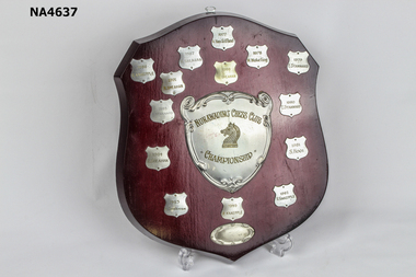
Award - Board - Honour, 1977
Mitcham Chess Club was established in 1970 and disbanded December 1976. Nunawading Chess Club reformed from Mitcham club January 1977 and disbanded permanently 1998. It operated from The Avenue Neighbourhood House Blackburn.Wooden Shield with central metal shield. 'Nunawading Chess Club' 'Championship' with etched Knight piece in centre surrounded by 14 small shields with winner from 1977 to 1991.|Names on shield A Van Silfliout - 1977, M. Walkling - 1978, E. Stannard - 1979, 1980, and 1985, S. Hooi 1981, R. Knaepple - 1982, 1986, 1989, R. Sheahan - 1983, 1984, 1987, 1988 and 1991.|Small oval unmarked shield on bottom.as abovetrophies & awards, sports -
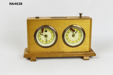 Whitehorse Historical Society Inc.
Leisure object - Chess Clock Timer
The Mitcham Chess Club was established in 1970 and disbanded Dec-1976. The Nunawading Chess Club reformed from Mitcham Club Jan-1977 and disbanded permanently in 1998. It operated from The Avenue Neighbourhood House, Blackburn.Wooden rectangular box sitting on rectangular base. The box contains two timing windup clocks used to time chess games. Two starter knobs on top. Metal label on top marked 'Olympia'. Metal clock faces with yellow background with brass coloured numbers and hands. Each clock has a red arrow on top. Back has brass circles with wind up mechanism; left hand side has knob to adjust time but not right clock.'Olympia' and repaired 8/83 Mitcham Chess Clubhorology, clocks, toys, games -
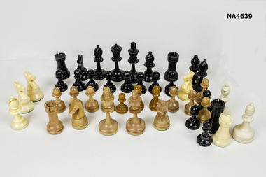 Whitehorse Historical Society Inc.
Leisure object - Chess pieces - 44
Mitcham Chess Club was established in 1970 and disbanded Dec 1976. Nunawading Chess Club reformed from Mitcham Club Jan 1977 and disbanded permanently 1998. It operated from The Avenue Neighbourhood House, Mitcham.Assorted chess pieces. Black pieces: 21, 7 ivory colour. Brown pieces: 3 brown wooden colour, 13 light brown colour.toys, games -
 Eltham District Historical Society Inc
Photograph, R.J. Manuell, Briar Hill, c.1964
View of Squires land which was subdivided for housing - two parts Woodland Crest higher part off Woodland Grove and Calrossi Avenue, Briar Hill showing new roads with curb and channelling and footpaths. No date.Black and white photograph printed with white bordersVerso: COO2briar hill, real estate, woodland grove, squires, roads -
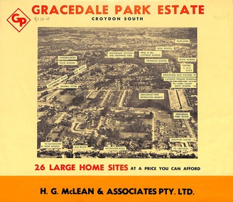 Ringwood and District Historical Society
Flyer, Land Sale Brochure, Gracedale Park Estate, Croydon South, Vic. circa 1968
Although the brochure advertises Gracedale Park Estate as Croydon South, the home sites and streets are in the 3135 postcode area, i.e. Ringwood East/Heathmont.Bi-folded orange coloured sheet with black print advertising sale of residential allotments, including subdivision features and local facilities.Sudivision includes Ringwood East streets - Gracedale Avenue and Raymond Court. Agent - H.G. McLean & Associates Pty. Ltd., 166 Canterbury Road, Heathmont. Telephone 870 3422, A/Hours 870 5879, 729 2809. -
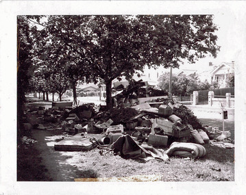 Kew Historical Society Inc
Photograph - Hard rubbish in the City of Kew
One of eight photographs donated by the City Engineer of the former City of Kew, mostly of hard rubbish clearance during the period 1969-1985.One of a dated series of photographs of core local government services as practised by the City of Kew in the period 1969-1985. Original black and white photographic positive of unburnable hard waste awaiting collection in Parkhill Road in the City of Kew.Reverse: "17th Nov 1969 8.45am. / Parkhill Road West of Adeney Avenue" In envelope marked: "Kew City Council / 12 photos / 1969 1979 18980 1985 / Unburnable rubbish units 18/1/80"garbage, hard rubbish, garbage removal, city of kew, local government -- city of kew, household waste, hard waste -
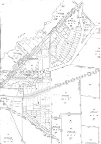 Ringwood and District Historical Society
Map - Survey Plans, Township of East Ringwood, Victoria - circa 1870s - 1950s
Photocopies of two 1878 Land Survey maps with names of early selectors and names and dates detailing subsequent land purchases to circa 1950s. Third map (digitised copy only) "The East Estate by 1927" (from A South Australian Colonist of 1836 and His Descendants by Sir Ronald East - page 147). Includes Bedford Road and Illoura Avenue, Ringwood East. -
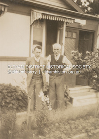 Eltham District Historical Society Inc
Photograph, Kenneth Douglas Ingram with his father, John at Anglesea, c.1949
John Ingram, baker of Research and his wife Ada (nee Key) owned a holiday house at 9 Minifie Avenue, Anglesea. At some time between 1943 and 1949 they relocated permanently to Anglesea. The house is named 'Glenair'.On reverse "Pop and son Ken"9 minifie avenue, anglesea, house, john ingram, kenneth douglas ingram, ada ingram (nee key), glenair, pam thoonen (nee ingram) collection -
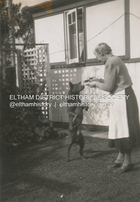
 Eltham District Historical Society Inc
Photograph, Ada Ingram (nee Key) at 9 Minifie Avenue, Anglesea, c.1949
John Ingram, baker of Research and his wife Ada (nee Key) owned a holiday house at 9 Minifie Avenue, Anglesea. At some time between 1943 and 1949 they relocated permanently to Anglesea. The house is named 'Glenair'.Inscribed on back "Ada Ingram"9 minifie avenue, anglesea, house, ada ingram (nee key), glenair, pam thoonen (nee ingram) collection -
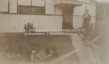
 Eltham District Historical Society Inc
Photograph, Ada Ingram (nee Key) at 9 Minifie Avenue, Anglesea, c.1949
John Ingram, baker of Research and his wife Ada (nee Key) owned a holiday house at 9 Minifie Avenue, Anglesea. At some time between 1943 and 1949 they relocated permanently to Anglesea. The house is named 'Glenair'.9 minifie avenue, anglesea, house, ada ingram (nee key), glenair, pam thoonen (nee ingram) collection, dog -
 Friends of Ballarat Botanical Gardens History Group
Slide - Colour transparency, Eastman Kodak, c. 1940
On March 2, 1940, Sir Winston Dugan, Governor of Victoria unveiled the busts of the six first prime ministers of Australia at a ceremony on the long avenue of Horse Chestnuts. The donor, Richard Armstrong Couch, was born in Ballarat in 1868.The Prime Ministers Avenue is a feature of national significance, set in the magnificent Horse Chestnut Avenue of the Gardens. The 28 Prime Ministers of Australia are displayed as bronze portraits mounted on polished granite pedestals. The collection includes a portrait of one of the founding fathers of Federation, Alfred Deakin, who was the first Federal Member for Ballarat and the second Prime Minister.Kodachrome slide depicting the gardens during the installation of the pedestals and busts of the first six prime ministers.Kodachromeballarat botanical gardens, trees, lawns, pathways, sculptures, busts, governors, prime ministers avenue, richard armstrong couch, federation, 1940, chestnut trees, horse chestnuts, bronze, granite, pedestals, alfred deakin, sir winston dugan, wallace anderson -
 Friends of Ballarat Botanical Gardens History Group
Slide - Colour transparency, Eastman Kodak, c. 1940
On March 2, 1940, Sir Winston Dugan, Governor of Victoria unveiled the busts of the six first prime ministers of Australia at a ceremony on the long avenue of Horse Chestnuts. The donor, Richard Armstrong Couch, was born in Ballarat in 1868.The Prime Ministers Avenue is a feature of national significance, set in the magnificent Horse Chestnut Avenue of the Gardens. The 28 Prime Ministers of Australia are displayed as bronze portraits mounted on polished granite pedestals. The collection includes a portrait of one of the founding fathers of Federation, Alfred Deakin, who was the first Federal Member for Ballarat and the second Prime Minister.Kodachrome slide depicting a pathway and lawns where pedestals and busts of the first six prime ministers are lying on the ground to be installed. A man with hat, long winter coat is standing on the pathway.Kodachromeballarat botanical gardens, trees, men, pathways, lawns, sculptures, busts, prime ministers avenue, chestnut trees, granite, alfred deakin, federation, horse chestnuts, richard armstrong crouch, pedestals, governor, sir winston dugan, wallace anderson -
 Kiewa Valley Historical Society
Photos - Mt Beauty Buildings in 1973. Set of 8, 1973
The shopping centre in Mt Beauty, both buildings and streetscape, have undergone significant changes since 1973. The kindergarten has undergone extensive remodelling, The Chalet has been replaced by Svarmisk Resort and Accommodation Spa. Tawonga hospital has undergone extensive renovation and is now Mt Beauty Hospital AND Kiewa Valley House. The Workman’s Club changed name to the Country Club and has since closed down. Hospital and Kiewa Valley House now occupy what is shown as a vacant lot opposite the motel which is now called Mt Beauty Motor Inn.The houses in Mt Beauty were brought in by the State Electricity Commission of Victoria when they constructed Mt Beauty Town for their workers building the Kiewa Hydro Electric Scheme. Mt Beauty is unique began as a construction town in the late 1940's.Colour photographs of various buildings in Mt Beauty taken in 1973 1. Workman’s Club 2. View over the pondage 3. Tawonga Hospital (Mt Beauty) 4. Mt Beauty Chalet 5. Mt Beauty Kindergarten 6. The Merjei Motel 7. 8 Valley Avenue 8. Shopping Centre Handwritten in ink on the back of photos 1. Workman’s Club 1973 (after the brick makeover) From the sports oval – the high school is to the right 2. A view over the pond 1973 3. Tawonga Hospital 1973 (Mt Beauty) 4. Mount Beauty Chalet 1973 5. Kindergarten 1973 6. The Merjei Motel 1973 7. Our house at 8 Valley Ave 1973, Owner after us erected the car port, let the front hedge run amok and vanquished the vegetable garden and citrus trees Dad created. 8. Shopping Centre 1973. At the end of the street is the hospital (believe it is now Mt Beauty Bush Nursing Hotel) mt beauty, workman's club, chalet, tawonga hospital -
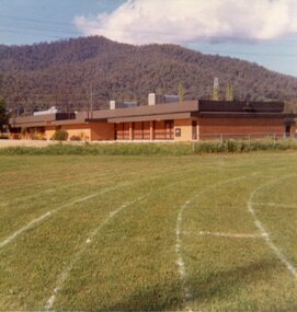
 Friends of Ballarat Botanical Gardens History Group
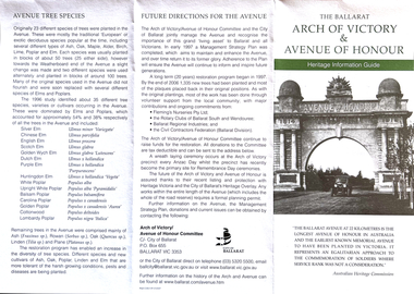
Work on paper - Heritage Information Guide, The Ballarat Arch of Victory and Avenue of Honour, 7/2007
This pamphlet provides comprehensive information on Memorials around Ballarat dating from May, 1917.Avenues of Honour are unique to Australia and found particularly Victoria. The Ballarat Avenue of Honour is of national importance as the longest and earliest known memorial tree planting of its type.This is an information pamphlet printed on both sides and folded into 3 sections. The headings are written in green and there is a black and white photograph of the Arch of Victory and the Avenue of Honour on the first fold. Over the page, there is a large diagram down the middle of the page, 2 black and white pictures of the righthand side and 2 sketches on the lefthand side of the page.None.john garner, doctor john garner, arch of victory, avenue of honour, heritage information guide, matilda l. thompson, tilly thompson, e.lucas &co pty.ltd, memorial wall project, memorial rotunda and roll of honour, memorial cairn and cross of remembrance, avenue trees and memorial plaques, ballarat city council., john garner collection, gardens, ballarat -
 Melbourne Tram Museum
Drawing, Melbourne & Metropolitan Tramways Board (MMTB), Aerial photographs Bundoora Tram Extensions, Plenty Road – MMTB Drawings – 12/1979, Bundoora Extension – Metropolitan Transit Authority – 2/1983, John-Connell – Mott Hay and Anderson – Preliminary drawings for the Latrobe Modal Interchange – August 1984, 1979 to 1984
Set of drawings for the MMTB Plenty Road extension in 1979, MTA extension to Bundoora in 1983 and the Latrobe Uni Modal Interchange - 1984. Large print – Aerial photographs Bundoora Tram Extensions Stage 2 – Albert St to Kingsbury Drive Stage 3 – Kingsbury Drive to Settlement Road Has been rolled, left hand edge damaged, right hand edge torn Compiled by the ROW Division – 2/1981. Has written on rear at right hand end “Bundoora Tram Extension – Official MMTB Plans” 760H x 1190W Plenty Road – MMTB Drawings – 12/1979 P15123 Tyler St to Walsal Avenue P15124 Walsal Ave t McColl St P15125 McColl St to Dorrington Avenue Bundoora Extension – Metropolitan Transit Authority – 2/1983 P15400 Dorrington Avenue to Barwon Avenue P15401 Barwon Avenue to Nicholson Ave P15402 Nicholson St to Barling Park P15403 Barling Park to Darebin Creek P15404 Darebin Creek to Scott Grove P15405 Scott Grove to Clunes Street P15406 Clunes St to Cash St P15408 Cash St to Bundoora Park P15409 Bundoora Park to Larundel Hospital P15410 At Larundel Hospital P15411 Larundel Hospital to Marne Court P15412 Marne Court to Cherrywood Court P15413 Cherrywood Court to Morwell Ave P15414 Morwell Ave to Grimshaw St P15415 Grimshaw St to Nickson Street P15416 Nickson St to McLeans Road John-Connell – Mott Hay and Anderson – Preliminary drawings for the Latrobe Modal Interchange – August 1984. 8094-A-20 Set Out Plan and Paving Details 8094-A-21 Elevations 8094-A-22 Sections 8094-A-23 Roof Plan and Stormwater Layout 8094-A-24 Canopy Details 8094-A-25 Toilet Block and Waiting Room 8094-A-28 Miscellaneous DetailsOn rear of aerial photograph sheet - at right hand end “Bundoora Tram Extension – Official MMTB Plans” in felt pen.trams, tramways, plenty rd, bundoora, latrobe university, mmtb, construction, mta -
 Surrey Hills Historical Society Collection
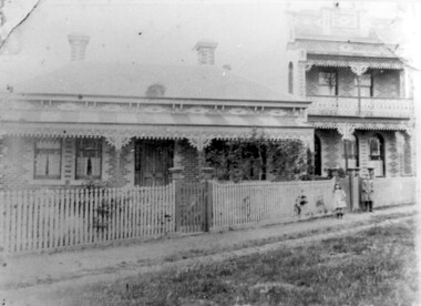
Photograph, 'Maitland', 1 Bedford Avenue, Surrey Hills, c 1900, 1900
Maitland' was built in 1889 for Thomas Zeplin, who was a Professor of Music. He owned all the land bound by Union Road, Wilson and Montrose Streets and the railway line. 1 Bedford Avenue stayed in family ownership until purchased by Camberwell Council in 1986, initially for a car park. However it was renovated to become part of Surrey Hills Neighbourhood Centre. It was opened on 23 November 1990. No 3 Bedford Avenue was built for Thomas Zeplin's daughter and named 'Mervyl' or 'Merryl'. Mrs Brodecky (donor) was the great-granddaughter of Thomas Zeplin. The 2 girls are granddaughters of Thomas Zeplin. Electoral roll information: 1972 & 1977: Albert Vojteck Brodecky, manager, 1 Bedford Avenue. 1977: Ray Nanette Brodecky. There are 2 copies. Thomas had this built for his son and family. The house was occupied by his family, though sometimes rented out. His great-grand-daughter Mrs. A. Brodecky sold to the Camberwell Council in 1986. This was the only surviving photo in the family after the fire. Courtesy: Mrs. A. BrodeckyBlack and white photo of 2 houses taken from the street front. On the LHS is a Victorian double-fronted single-storey villa of Hawthorn brick construction, with wrought iron lacework to the veranda, slate roof and picket fence, with an established garden. Next door at No 3 is a double-storey Victorian terrace with a similar fence and building materials. There are 2 young girls standing in front between the properties.maitland, bedford avenue, 1900, surrey hills neighbourhood centre, victorian style, mervyl, merryl, mr thomas zeplin, mrs nanette brodecky, mr albert vojteck brodecky -
 Ringwood and District Historical Society
Pamphlet, Land Sale Brochure Titled Eureka Plan Book - Seven Delightful & Valuable Ringwood Estates - circa 1925
Twenty page land sale brochure including photographs, subdivision features and local facilities. Additional flyer with conditions of sale and prices for estate blocks.Seven delightful and valuable Ringwood Estates called Bestpart, Paradise, Hill Top, Greenwood, Creek, Station, and School Estates. These nestle amidst the hills and valleys of beautiful Ringwood district. Also Goodluck Estate at Clarinda. Pamphlet marked as being From Mr. Farmer, No. 5 Flinders Court, Melbourne. Phone 988, 989 Central, or 55 Ringwood after 7 p.m. Plan of Ringwood School Estate includes William Street (later Kendall Street), Greenwood Avenue, Alton Street and Locke Street. Plan of Bestpart Estate, Ringwood, includes Bedford Road, Wilana Street, Greenwood Avenue, Caroline Street, Henry Street and Haig Street. Plan of Ringwood Station Estate includes Pitt Street, Bedford Road, Greenwood Avenue, Station Street, William Street (later Kendall Street, James Street, Wantirna Road, Caroline Street, Henry Street, Ellison Street and Haig Street. Plan of Geenwood Estate, Ringwood, includes Prussian Road (later Geenwood Avenue). Plan of Paradise Estate, Ringwood, includes Canterbury Road, Dandenong Road (Wantirna Road), Luck Street and Paradise Road. Plan of Creek Estate, Ringwood, includes Dandenong Creek, Wantirna Road and Gordon Crescent. Plan of Hill Top Estate, Ringwood (later Heathmont area), includes Heathmont Railway Station, Heathmont Road, Balfour Avenue, Lilian Street, Edith Street, Edna Street and Great Ryrie Street. Plan of Goodluck Estate, Clarinda, includes Talbot Avenue, Good Street, Luck Street, and Centre Road in locality plan between Oakleigh and Clayton Railway Stations. -
Glen Eira Historical Society
Document - Vadlure Avenue, 2, St. Kilda East
Printed and handwritten research from Brighton Historical Society giving brief details on 2 Vadlure Avenue, regarding subdivision of land formerly grounds of Kilwinning and residents of property from 1931 to 1974. Dated 19/01/1988.vadlure avenue, st. kilda east, service james, land subdivisions, 'kilwinning', denman street, kosky samuel, mcardle daniel j., elisha e., elisha d., bullock h., landells rosalind -
 Phillip Island and District Historical Society Inc.
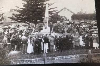
Photograph, 25/4/1920
One of a collection of photographs purchased from Photo First, Thompson Avenue, Cowes, when it closed in June, 2014. The opening of the War Memorial on the Cowes foreshore near the Jetty was unveiled by Mr Henry Brand, Anzac Day 1920. Large Black & White photograph of a crowd at the opening of the Cowes War Memorial, near the Jetty and opposite the Isle of wight Hotel. Very wet day as people with umbrellas to keep the rain off.cowes war memorial, mr henry brand, anzac day, photo first phillip island -
 Greensborough Historical Society
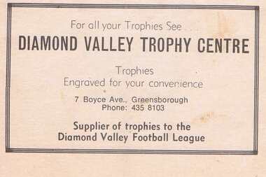
Advertisement - Digital Image, Diamond Valley Trophy Centre 1983, 03/09/1983
Advertisement for Diamond Valley Trophy Centre of Boyce Avenue Greensborough. Copied from a Diamond Valley Football League football record from 1977. In 2020, Diamond Valley Trophy Centre operates from Beewar Street Greensborough.Digital copy of advertisement from booklet.diamond valley football league, diamond valley trophy centre, boyce avenue briar hill, beewar street greensborough