Showing 3905 items matching " bricks"
-
 Eltham District Historical Society Inc
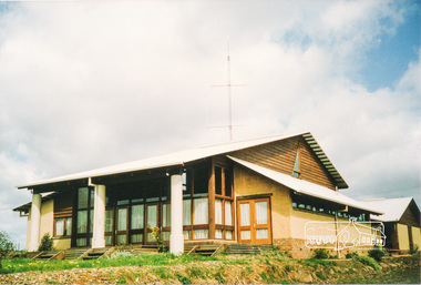
Photograph, Emergency Operations Centre, S.E.S., Kangaroo Ground
In 2017 known as the Kangaroo Ground Operations Centre a facility for hire managed by the Shire of Nillumbik. On 7 February 2009 (Black Saturday) the CFA Incident Control Centre (ICC) was located here. Described in "Worst of Days: Inside the black Saturday firestorm" by Karen Kissane (access via Google books): "..the ICC is part of a mud brick complex built in the 1980s as an emergency operations centre for several agencies, including the State Emergency Service. It is also home to the headquarters of the CFA's Lower Yarra Group. A small office with a whiteboard would be the incident controller's office throughout the office, but a larger central room, with data projectors, "smart boards" and maps would house the rest of the team.."Statement of Significance From the Victorian Heritage Database (2010) What is significant? The 1988 emergency operations centre and the surrounding site to the title boundaries. How is it significant? The emergency operations centre is architecturally, aesthetically, socially and historically significant to the Shire of Nillumbik. Why is it significant? The emergency operations centre is architecturally and historically significant as a good and rare example of a large public building constructed in a 1980s version of the 'Eltham style', and as a rare attempt to adapt the 'Eltham-style' aesthetic to meet the changing demands of the Shire in the 1980s (Criteria B, D & E). The emergency operations centre is architecturally and aesthetically significant because it is constructed of mud brick and features: a central entry with a tile mural (Criterion E). The emergency operations centre is socially significant because it is a focal point for the community and has played an important role in protecting the community since 1988 (Criterion G).Two colour photographs of mud brick Emergency Operations Centre building, Kangaroo Groundbuildings, mud brick, emergency centre, kangaroo ground -
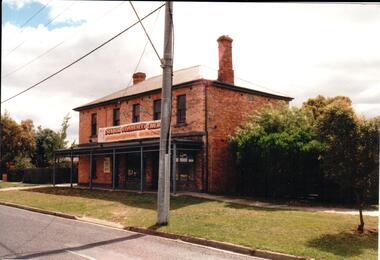
 Sunbury Family History and Heritage Society Inc.
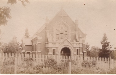
Photograph, St. Andrew's Presbyterian Church
The Government first granted land for the building of a Presbyterian Church in Sunbury in Stawell Street and Barkly Street, in 1864 and a smaller building was later erected on the site. In 1904 Rev Goyen pressed for a brick church rep[lace the smaller weather board building and the foundation stone was laid for the new church was laid by Mrs. John Duncan on 17th August 1904 and the new church opened by Lady Clarke on 13th November 1904.The Presbyterian Church was one of the earliest churches to be established in Sunbury along with a school.A non-digital sepia photograph in post card format of the front view of a brick church with a light picket fence across the front. -
 Ringwood and District Historical Society
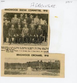
Document, Packet: Agriculture (Ringwood): Cuttings, Handwritten ""Sowing Wheat" Notes (Greg Dawson), 1909-1986
Agriculture; Poultry; Wheats; Dams; Mud Bricks; Ringwood Show Committee 1910 +Additional Keywords: Dawson, GregPacket includes: . Newspaper cutting showing Ringwood Show Committee, 1910, and Ringwood Orchard, 1910. . Letter from the Ringwood Fruit Association Limited dated 3 September, 1921 re supply of bluestone. . Hand written note on report of Ringwood Show 1909. . Extract from "The Victorian Poultry Journal" 1931 about the formation of a branch at Ringwood. . Extract from notes written by Mr. Greg Dawson of Merrigum aged 94, 1967, re sowing wheat, dams, mud bricks, and school. -
 Flagstaff Hill Maritime Museum and Village
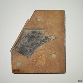
Equipment - Pattern, Briggs Brass Foundry, Early 20th century
The wooden pattern was possibly made for casting a part for Craftman Marine, makers of engines for boats and other machines. It is part of a set that is stored in a strong wooden crate. It was used at Briggs’ Brass Foundry for making sand casts. The traditional craft of sand casting is over 2000 years old. The handcrafted process produces brass and copper alloy goods that are well suited to marine use; bells, boat hooks, cowls, propellers, handles, lids, rowlocks, hooks, letters, bolts, rail holders, brackets, deck plates, flanges, rudder guides, portholes and covers. Briggs’ Bronze mixture is a copper-based alloy made from local ingots of copper, tin, zinc and lead in carefully measured quantities. The finished product is non-ferrous and can last indefinitely. The crate of patterns was donated by the Briggs family in the early years of Flagstaff Hill, along with other related items such as brassware, tools and machinery. The donated items were displayed in a simulated Brass Foundry in the Village along with other working crafts, trades and services found in a Maritime town. The items were on show from the completion of the building in 1986 until 1994 when the building was repurposed. The patterns represent the trades of foundering and metalwork, both supporting maritime industries such as shipwrights and boatbuilders. Farmers, manufacturers and other local industries also needed the castings made by foundries. The Brass Foundry included a historic Cornish chimney set up as a working model, to tell the story of smelted metal heated in furnaces then be poured into the sand moulds. This chimney was made from specially curved bricks and is now about two-thirds of its full height when originally located at the Grassmere Cheese factory. The craft of sand-casting from carved wooden patterns to create metal is an example of skills from the past that are still used today. The foundry pattern set is significant for its association with brass foundries locally and generally in coastal areas of Victoria. Marine industries such as ship and boat building rely on good quality castings for their machinery, equipment and fittings. Briggs Brass was especially formulated using non-ferrous metals to ensure their longevity. The patterns are associated with the long-running firm Briggs Brass Foundry that specialised in cast goods for the marine industry, ready to supply the needs for once-off or mass-produced items. Their products would have been fitted to sail and steam vessels along coastal Victoria including Warrnambool. Briggs Marine was also a bell-founder specialist and is also associated with the Schomberg Bell at Flagstaff Hill, having restored it to is former state as a fine example of the bell from a luxury migrant vessel from the mid-19th century. Pattern; rectangular wooden block with a corner cut diagonally. A five-sided shape has been carved into the centre, with one side curved inwards and slightly shallower than the other sides. The cut-out area is painted black. Three holes are drilled in the cut-out side to align the pattern with another piece of work. A wooden slat is fixed across the diagonal side. The back of the pattern has a handwritten inscription, possibly by two writers. The pattern is part of a set of foundry patterns from Briggs Brass Foundry and is connected to Craftman Marine.In black handwriting: "1 # H AL" Handwritten in a different hand: "CRAFTMAN MARINE" Written the the first hand: BRIGGS" (or "BRICK")flagstaff hill, flagstaff hill maritime museum and village, warrnambool, maritime museum, maritime village, great ocean road, shipwreck coast, briggs' bronze, traditional method, trade, sand cast, cast, brass alloy, copper alloy, pattern, mould, foundry, brass foundry, metal foundry, casting, sand mould, sand casting, marine equipment, marine tools, marine fittings, copper tin zinc lead, non-ferrous, non-corrosive, brassware, metalware, foundering, metalwork, maritime, bell founders, ship chandlers, marine products, biggs, briggs family, herbert harrison briggs, h h briggs, george edward briggs, cyril falkiner mckinnon briggs, cyril briggs, briggs & son brass foundry, h h briggs & sons foundry, briggs marine, alliance casting & engineering solutions, grassmere cheese factory, cornish chimney, curved bricks, collingwood, moorabbin, collingwood foundry, moorabbin foundry, 1912, craftman marine, craftsman marine -
 Stawell Historical Society Inc
Photograph, 39 Main Street
39 Main Street: Mr Tom Healy did boot & shoe repairs from shop at front of house.Colour Photgraph. Brick home with brick fence. Small brick building opening onto footpathOn reverse: Shop where Tom Healy worked in Lower Main Streetbusiness, tom healy -
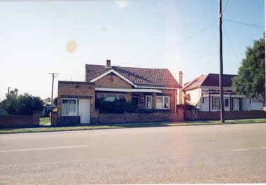
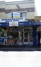 Glen Eira Historical Society
Photograph, Murrumbeena Road, 229, Murrumbeena, 2001
Originally labelled "Beauville Estate, Established 1936, Still Thriving 65 years on, 10th March 2001", the Beauville Estate Album contains colour photographs of houses in the Estate. They were taken around the time of the Beauville Estate’s 65th Heritage Celebration held on 10/03/2001 and donated to the Caulfield Historical Society shortly afterwards. Photographer unknown. From Glen Eira’s Heritage Management Plan by Andrew Ward (1996) Vol 2 p78: In Murrumbeena Road, the shops which form part of the estate are a simple cream brick row relieved by manganese bricks in bands across the upper storeys. City of Glen Eira’s Heritage Management Plan Vol 2 p79 (this is p84 of the pdf version) – HO12 Beauville Estate and environs, Murrumbeena: The Beauville Historic Area is important at the State level as the first large housing estate undertaken by the AV Jennings Construction Co, later Jennings Group Limited, Victoria’s largest home builder. It is important also as a very early estate development incorporating a range of features other than houses and including made roads, shops and recreation facilities. In this respect it was the forerunner of the comprehensively planned housing estate of the post war era. The estate is distinguished by its aesthetic values, as is the earlier and comparable Hillcrest Estate, which are formed by a combination of restrained diversity in house styles, with the exception of no. 30 in the emerging International style, and by a landscaped garden environment. Colour photograph of a section of a double storey, unpainted brick, commercial property containing shops at ground level all with awnings over the footpath. This specific property is a milk bar on street level with plate glass windows and door, colourful advertising and "229' in the top right section of the window. Shop signage says "MURREMBEENA MILK BAR". The upper storey brick residence features a large window, a flat roof and decorative two tone banded brickwork. MURREMBEENA (sic) MILK BAR / PK's / SANDWICH / BAR / MILK BAR & Sandwich Bar / 229 / SUB NEWSmurrumbeena, architectural styles, 1930's, inter war style, a.v. jennings, av jennings, jennings, beauville estate, murrumbeena road, milk bars, commercial establishments, flats, sir albert victor jennings, a v jennings construction co, beauville estate heritage area, glen eira city council, architectural features, jennings group limited, land subdivision, beauville historic area, shops, brick features, window displays, advertising signs, murrembeena (sic) milk bar -
 Lakes Entrance Historical Society
Photograph - Historic House, Davies, Judy, 2000
House provided by the community for Miss Hammarstrom and family after Mr Hammerstrom, a fisherman, was lost at sea in 1926. The Age newspaper collected 400 pounds in an appeal to support the family. House was originally timber clad. Also one other colour photograph similar, side of building, fibro cladding and two brick chimneys.Colour photograph of a small fibro cement cottage. Corrugated iron gable roof, two substantial brick chimneys, at 43 Roadknight Street, Lakes Entrance Victoria houses, accommodation, heritage study -
 Sunbury Family History and Heritage Society Inc.
Photograph, Royal Hotel
The two storey building in the photograph is the Royal Hotel. The original single storey hotel was damaged by fire in the 1930s so the double storey red brick building replaced it on the same site, which is at the intersection of Evans and Brook Streets. For many years the MIllett family owned and ran the hotelThe Royal Hotel is one of four hotels that operated in Evans Street between Station and Brook Streets. Only two of those hotels are operating on their original sites. The other two have been demolished and replaced with retail businesses.An enlarged black and white non-digital photograph with a narrow cream border of a streetscape of an intersection with a two storey brick building on one corner and cars park by the kerb outside the building.royal hotel, millett family, evans street, brook street, hotels -
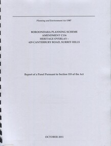 Surrey Hills Historical Society Collection
Book, Boroondara Planning Scheme Amendment C116 Heritage Overlay - 629 Canterbury Road, Surrey Hills, Oct-11
Report of a panel pursuant to Section 153 of the Planning and Environment Act regarding the property at 629 Canterbury Road, Surrey Hills - an Edwardian two story red-brick butchers' shop built in 1897 for the Tacey family.Report of a panel pursuant to Section 153 of the Planning and Environment Act regarding the property at 629 Canterbury Road, Surrey Hills - an Edwardian two story red-brick butchers' shop built in 1897 for the Tacey family.abermore pty ltd, heritage studies, tacey family butchers, surrey hills, canterbury road, (ms) natica schmeder, sherry james, jo james, (mr) mark marsden, (mr) bryce raworth, 2011, 1897 -
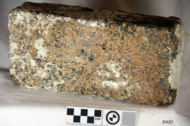 Flagstaff Hill Maritime Museum and Village
Brick
According to Lloyds Shipping Register 1837-1839, the CHILDREN was built in 1825 at Liverpool and operated by owners Gordon & Co, of London. London registered number 123/1837. James Henty then bought her in 1837 as a three-masted barque of 254 tons, with a hull of “part pitch pine, felt sheathed” and “coppered 1837”. Launceston registered number 6/1837. In 1838 the CHILDREN, under her master Captain H. Browne, completed a successful round trip from Launceston to London (carrying wool and whale oil loaded in Portland), returning in late November of that year (carrying a general cargo including the house bricks). On the 11th January 1839, the CHILDREN sailed from Launceston for Adelaide, with 24 passengers, 14 crew, and an awkward mixed cargo, including 1500 sheep, 8 bullocks, 7 horses, and farming implements, and six whaleboats with associated whaling gear. One account states that when the CHILDREN “put out from port she was light and badly ballasted”. The vessel immediately encountered four days of hurricane force storms, eventually clearing on the early morning of the 14th to “west force 10”, but too late to take accurate measurements of the sun or stars to establish their position relative to the coast. The CHILDREN collided with a limestone stack at the entrance of Childers Cove, and the seas smashed her into pieces within half an hour. All the cargo and 16 lives were lost (including 8 children). The Hentys contributed £150 towards a fund for the 22 survivors at a memorial service held in Launceston later that year. It was a major financial setback for the Henty’s, but one from which they recovered. In a submission to the Governor of New South Wales dated 24 March 1840, the Henty’s summarised their work over the previous six years of settlement: “Six stations have been occupied, one at Portland Bay…three at the open country about 60 miles inland called ‘Merino Downs’…They have erected two houses at Portland Bay and two others at Merino Downs”. The shipwreck of the CHILDREN is of State significance ― Victorian Heritage Register S116Fired brick from the wreck of the Children, flagstaff hill, warrnambool, shipwrecked-coast, flagstaff-hill, flagstaff-hill-maritime-museum, maritime-museum, shipwreck-coast, flagstaff-hill-maritime-village, children -
 Hume City Civic Collection
Photograph, Early 1990's
The series of five photographs feature various stages of the demolition of a double fronted brick Victorian cottage which was on the east side of Evans Street opposite the railway line and local football ground. A KFC complex now occupies the site.A coloured photograph in landscape format showing a double fronted Victorian brick cottage undergoing demolition. The slates on the roof have been removed. The front and side walls are intact. Some rubble is on the ground in front of the verandah.victorian cottages, house demolitions, evans street, george evans collection -
 Kew Historical Society Inc
Photograph - Former Congregational Church, Walpole Street, Stewart West, 1977
The site of the former Kew Congregational Church was the earliest 'built' place of religion in Kew. An earlier building by Charles Vickers was replaced by a new brick church designed by Albert Purchas. Following the creation of the Uniting Church, the church at 30 Walpole Street was declared redundant and demolished to make way for the Bodalla Nursing Home (itself later demolished).Colour print positive of the former Congregational Church in Walpole Street, Kew. A side on view of the red brick and concrete renders building showing the small steeple and the front entrance."Oldest church in Kew. Taken Oct 1977. Formerly Congregational church"churches -- kew (vic), congregational churches, walpole street -- kew (vic), albert purchas -
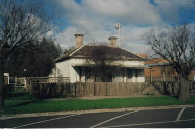
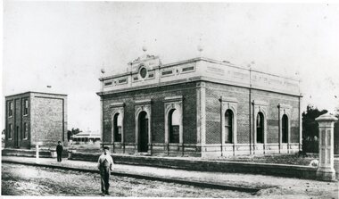 Stawell Historical Society Inc
Photograph, Stawell Shire Hall 1866
This photograph is a copy obtained from State Library of Victoria. The photograph is of Stawell Shire Hall. Two persons can be seen in the foreground. The two story brick building beside the Stawell Shire Hall was once the Literary Institute. The Stawell Shire Hall building has been added to over the years. Ronald Campbell, the Shires second president laid the foundation stone on 28th April. 1866. The contractors were Hutchings and Delbridge. The photograph shows the first hall and office. The building contained simple 18 feet square rooms, with an entrance hall separating them, the facade was almost as it is now. The initial cost of the Shire Hall was $502.Black and white photograph of Stawell Shire Hall as one single storey brick building with parapet on top. Beside the Shire Hall is a two storey brick building. Also, a dwelling between the two building in the background in Cooper St. Two persons in the foreground, one on the road the other on the pathway. stawell -
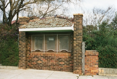 Stawell Historical Society Inc
Photograph, Brick Ticket Box at Central Park c 1937 -- Coloured
Brick Ticket Box built around c 1937. This photo of the Ticket Box is located in Lower Main St, and on the right side of main gates to Central Park.Colour photo of Brick Ticket Box, Lower Main St, at Central Park located right side of main gates. Photo taken in 1999. Photo shows the tile roof with moss growing all over the tiles. The three windows are covered with a white security mesh.stawell central park -
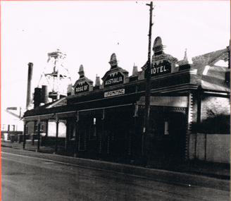 Bendigo Historical Society Inc.
Photograph - LONG GULLY HISTORY GROUP COLLECTION; ROSE OF AUSTRALIA HOTEL
Earliest newspaper record show that the Rose of Australia Hotel was operating by October 1855. The fire that burnt the wooden hotel down occurred 29th November 1907. It was then rebuilt in brick.Black and white photo of the Rose of Australia Hotel. It has the name painted across three decorative pediments at roof level. The licensee's name, H. Paynting, is painted beneath the centre pediment. The building is brick with white bricks at the corners and around the windows and doors. It has a bull-nosed veranda with iron lace and decorated veranda posts. The photo is quite dark beneath the veranda. There is a house next door and behind that is a poppet legs, a tall chimney, what looks like two smaller chimneys and a mine building. It is situated on Eaglehawk Road. The photo is mounted on an orange card which is mounted on a tan card and laminated.bendigo, history, long gully history group, the long gully history group - rose of australia hotel, h paynting -
 Stawell Historical Society Inc
Photograph, Hobbs Family House at 10 Seaby Street Stawell 1997
Private Home - 10 Seaby Street (Hobbs) 1997. Built by Mary Ellen Hobbs widow of William Hobbs Paid for by proceeds of Mine Investments Later purchased by Frank & Lorraine Stokes.Brick House with brick front fence in Seaby Street Stawell.stawell -
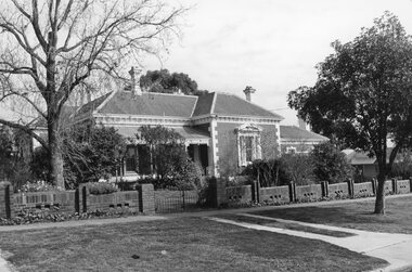
 Kew Historical Society Inc
Photograph - Victorian Double-fronted Brock Villa, Cotham Road, c. 1919
The Kew Historical Society's map collection includes a substantial number of real estate subdivision plans, mainly of Kew but also of surrounding suburbs in Melbourne. Most of the subdivision plans date from the 1920s and 1930s when the districts old homes and local farmland were being split up to accommodate residential growth in the postwar period. These early plans were assembled by a local firm, Jas R Mather & McMillan, which had an office in Cotham Road. Many of the plans, and sometimes photos, were annotated by the agents.Subdivision plans are historically important documents used as evidence for the growth of suburbs in Australia. They frequently provide information about when the land was sold as well as evidence relating to surveyors and real estate and financial agents. The numerous subdivision plans in the Kew Historical Society's collection represent working documents, ranging from the initial sketches made in planning a subdivision to printed plans on which auctioneers or agents listed the prices for which individual lots were sold. In a number of cases, the reverse of a subdivision plan in the collection includes a photograph of a house that was also for sale by the agent. These photographs provide significant heritage information relating house design and decoration, fencing and household gardens.The photograph may also be aesthetically significant depending o the importance of the photographic atelier.Real estate photographs of a classic double-fronted late Victorian brick villa. It central location in Cotham Road, Kew enabled the selling agent to note its proximity to the tram. With seven rooms, all ‘modern conveniences’, and land of 66×167, the house was to be sold for £1100. The villa has a number of interesting features including a pattern within the slate roof as well as the use of polychrome brickwork under the eaves and on the façade. The intricacy of the cast iron lace is emphasised by the line of projecting wooden blocks above it. The picket gate is painted a different colour to the pickets of the fence. The house has a name (illegible) that is attached to the inset cast iron lace of the central projecting gable in the veranda. Stamped on mount: "Kew. Central. Close tram. / Comfortable Brick Villa. / Containing 7 rooms / Modern conveniences: / Land 66 x 167. Sold 1100 pounds:"houses - kew, victorian villas, real estate photographs, cotham road - kew -
 Hume City Civic Collection
Photograph
Since it was built in the 1860s the two storey brick building has had a number of commercial uses including butter and ice making, a general store, an equestrian store, an art gallery, a community Christian centre and a health studio. It has apparently been built in two stages because one section of the brickwork has a smoother finish.A coloured photograph of a two storey brick building with a slate roof. There is a shop front on the ground floor and 5 windows are on the 2nd storey. A verandah extends across the front of the lower storey to the edge of the footpath.butter and ice making, johnston, george, james, william, george evans collection -
 Buninyong & District Historical Society
Photograph - Colour Photograph, Home of the Coxall family, "Webville", c 1990
The Coxall family were early settlers of the Buninyong district.Relic of an early Buninyong home.Bluestone building with red brick gable and brick circular window frame."Webville" Coxall family home, c 1990coxall family, house, buninyong -
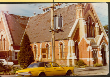
 Surrey Hills Historical Society Collection
Photograph, Surrey Hills Methodist Church in 1918, 1918
The original Methodist (Wesleyan) Church was built on the corner of Alexandra Crescent and Windsor Lane in 1888. It was enlarged in 1892. In 1908 this building was removed to Valonia Avenue by horse-drawn dray. The brick church was built in 1915 after which the earlier building became the Sunday School. In 1977 the Methodist Church joined with others to become the Uniting Church. In more recent times, the brick church has been painted but architectural details visible in this photo can still be discerned.Black and white photo of a brick and rendered building taken from diagonally opposite across Canterbury Road looking to the north-west. The church sits behind a woven-wire fence with an opening at the front and at the side to a portico off Valonia Street. On the RHS is the church hall and on the LHS a small part of the adjacent house can be seen.surrey hills methodist (wesleyan) church, surrey hills uniting church -
 Stawell Historical Society Inc
Photograph, Salvation Army Citadel Opening 1934
Photograph on mounted card taken at the official opening of Citadel Main Street Stawell. In the background a private dwelling with corrugated iron roof and weatherboard walls. At right brick building. Bands people and civilians standing around a flagpole. To the right of the flagpole. Mrs. Maxwell (standing on the brickwork), Mr. W. Freeland (Major). Commissioner Maxwell. Mr. W. Sharpley (Town Clerk) Major Wilkinson.Black & white photo on a mounted card with a boarder. The photo is of a group of people some with musical instruments beside a flagpole. In the background is a weather board house with a corrugated iron roof. To the right a brick building. W. J. Chapman Photo Artist Stawell. Reeve (in pencil).stawell religion -
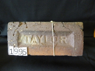 Stawell Historical Society Inc
Memorabilia - Realia
Taylor - Brickstawell -
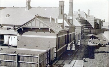 Sunbury Family History and Heritage Society Inc.
Photograph, Sunbury Asylum, c1920s
The brick buildings in the photograph are of the former Sunbury Asylum and F3 Ward is in the foreground. Initially the site on Jackson Hill also known as She0ak Hill opened as an Industrial School for orphaned or neglected children and in 1879 it became an asylum where it continued to function as an asylum until the Victorian Government closed it on 20th November 1992.The Sunbury Asylum played an important part in Sunbury and wider community's development over 150 years. throughout its existence there was much interaction between the residents, staff and local community, many of whom were employed at 'The Hill' as it was known locally. A sepia non-digital photograph of a large brick hospital building with three nurses standing outside it on a narrow pathway edging a garden bed. A picket fence is at the rear of the building enclosing a small yard where washing is drying on the line.sunbury asylum, jackson hill, caloola, sheoak hill, ward f3 -
 Glen Eira Historical Society
Album - Album page, Glen Huntly Road, Circa 1972
This photograph is part of the Caulfield Historical Album 1972. This album was created in approximately 1972 as part of a project by the Caulfield Historical Society to assist in identifying buildings worthy of preservation. The album is related to a Survey the Caulfield Historical Society developed in collaboration with the National Trust of Australia (Victoria) and Caulfield City Council to identify historic buildings within the City of Caulfield that warranted the protection of a National Trust Classification. Principal photographer thought to be Trevor Hart, member of Caulfield Historical Society. Most photographs were taken between 1966-1972 with a small number of photographs being older and from unknown sources. All photographs are black and white except where stated, with 386 photographs over 198 pages. From: Glen Eira Heritage Management Plan (1996) by Andrew Ward and Associates This Area is marked by the imposing brick and freestone gothic Revival church of the Holy Cross, built in 1937 to the design of O.H. Jorgensen. Church of the Holy Cross and Presbytery are contributory buildings to HO66.Page 65 of Photograph Album with one exterior photograph (landscape) of a brick church with a three storey tower.Hand written: Glenhuntly Rd [top left] / HOLY CROSS RC CHURCH / Dec 1972 [written underneath the photo] / 65 [bottom left] trevor hart, 1930's, gothic revival, brick, bell tower, spire, facade, catholic church, o h jorgensen, holy cross catholic church, caulfield, glenhuntly road, caulfield south, presbytery -
 Sunbury Family History and Heritage Society Inc.
Photograph, Rosa McCall, Former Sunbury State School, 15th October 2000
The photograph was included in an exhibition organised by the former Sunbury & District Heritage Association in March 2001. The red-brick Federation building for Sunbury State School No. 1002 in Macedon Street opened on 2nd May 1912. It replaced an earlier building that was on the same site. It originally had two classrooms and an office but as Sunbury's population began to grow another room was added. The school continued to function in Macedon Street until 1999 when it took occupancy of refurbished rooms at the former Industrial School in the Asylum Grounds at Jascksons Hill. The building in Macedon Street has been incorporated into the Sunbury and Cobar Community Health Centre. The red-brick Federation Style Sunbury building has served the educational needs of the Sunbury Community for 112 years as it is now an Educational facility for people with disabilities.A non-digital coloured photograph go a red-brick federation school building with cream trims around the windows and doors.Two trees are growing in the foreground.sunbury state school no. 1002, macedon street, education, schools -
 Sunbury Family History and Heritage Society Inc.
Photograph, 13 Evans Street, Sunbury
The cottage in the photograph was situated at 13 Evans Street in Sunbury and was one of the last houses to be demolished along the business of Evans Street between Brook and Macedon Streets. The cream brick building on the RHS of the house is a Telstra complex. The cottage was demolished in the early 2000s and a fast-food outlet now occupies the site. The cottage was one of a group of small attractive buildings erected along the northern end of Evans Street in the second half of the nineteenth century.A non-digital coloured photograph of a small double fronted Victorian cottage with a slate roof and a verandah across the front of the house. A cream brick structure with a signal tower is on the RHS of the photograph and a large bare elm tree is growing on the nature-strip. 13 evans street, victorian cottages, evans street, telstra -
 Kew Historical Society Inc
Photograph - Entrance to Boroondara General Cemetery
Boroondara Cemetery, established in 1858, is within an unusual triangular reserve bounded by High Street, Park Hill Road and Victoria Park, Kew. The caretaker's lodge and administrative office (1860 designed by Charles Vickers, additions, 1866-1899 by Albert Purchas) form a picturesque two-storey brick structure with a slate roof and clock tower. A rotunda or shelter (1890, Albert Purchas) is located in the centre of the cemetery: this has an octagonal hipped roof with fish scale slates and a decorative brick base with a tessellated floor and timber seating. The cemetery is surrounded by a 2.7 metre high ornamental red brick wall (1895-96, Albert Purchas) with some sections of vertical iron palisades between brick pillars. Albert Purchas was a prominent Melbourne architect who was the Secretary of the Melbourne General Cemetery from 1852 to 1907 and Chairman of the Boroondara Cemetery Board of Trustees from 1867 to 1909. He made a significant contribution to the design of the Boroondara Cemetery. (Source: Heritage Victoria)This photograph is one of the earliest known photographs of the cemetery, showing the early plantings and fences.Later print copy of an undated original photographic positive of the entrance to the Boroondara General (Kew) Cemetery. The Cemetery had been opened in 1855. This view is from Bulleen Road (now High Street) showing a group of 12 or 13 men standing in a line outside the entrance. At this time, the clocktower and high brick fence had not been constructed, but the trees have reached a substantial heightPencil inscription on reverse - "Boroondara Cemetery Entrance 1862"boroondara general (kew) cemetery, cemeteries -- melbourne (vic.) -
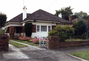 Glen Eira Historical Society
Photograph, Beauville Avenue, 37, Murrumbeena, 2001
Originally labelled "Beauville Estate, Established 1936, Still Thriving 65 years on, 10th March 2001", the Beauville Estate Album contains colour photographs of houses in the Estate. They were taken around the time of the Beauville Estate’s 65th Heritage Celebration held on 10/03/2001 and donated to the Caulfield Historical Society shortly afterwards. Photographer unknown.City of Glen Eira’s Heritage Management Plan Vol 2 p79 (this is p84 of the pdf version) – HO12 Beauville Estate and environs, Murrumbeena: The Beauville Historic Area is important at the State level as the first large housing estate undertaken by the AV Jennings Construction Co, later Jennings Group Limited, Victoria’s largest home builder. It is important also as a very early estate development incorporating a range of features other than houses and including made roads, shops and recreation facilities. In this respect it was the forerunner of the comprehensively planned housing estate of the post war era. The estate is distinguished by its aesthetic values, as is the earlier and comparable Hillcrest Estate, which are formed by a combination of restrained diversity in house styles, with the exception of no. 30 in the emerging International style, and by a landscaped garden environment. See Significance Statement in Glen Eira’s Heritage Management Plan by Andrew Ward (1996) Vol 2 p.79. Available from https://www.gleneira.vic.gov.au/media/4779/heritage_management_plan_volume_2.pdf (Note see p.84 of pdf)Colour photograph of white rendered house with unpainted variegated brown brick features including a wide brick band around the house. Other features include an open porch with brick pillar, striped awning on side windows, tiled roof, chimneys with identical brick features and low unpainted matching brick fence in the foreground with "37" on the brick pillar and white cast iron gate beside the driveway.murrumbeena, houses, beauville avenue, architectural styles, 1930's, inter war style, a.v. jennings, av jennings, jennings, brick houses, beauville estate, porches, sir albert victor jennings, a v jennings construction co, beauville estate heritage area, glen eira city council, architectural features, jennings group limited, land subdivision, gardens, beauville historic area, rendered houses, brick features, striped awnings, chimneys, brick fences, cast iron gates -
 Glen Eira Historical Society
Photograph, Gloucester Court, 3, Murrumbeena, 2001
Originally labelled "Beauville Estate, Established 1936, Still Thriving 65 years on, 10th March 2001", the Beauville Estate Album contains colour photographs of houses in the Estate. They were taken around the time of the Beauville Estate’s 65th Heritage Celebration held on 10/03/2001 and donated to the Caulfield Historical Society shortly afterwards. Photographer unknown. City of Glen Eira’s Heritage Management Plan Vol 2 p79 (this is p84 of the pdf version) – HO12 Beauville Estate and environs, Murrumbeena: The Beauville Historic Area is important at the State level as the first large housing estate undertaken by the AV Jennings Construction Co, later Jennings Group Limited, Victoria’s largest home builder. It is important also as a very early estate development incorporating a range of features other than houses and including made roads, shops and recreation facilities. In this respect it was the forerunner of the comprehensively planned housing estate of the post war era. The estate is distinguished by its aesthetic values, as is the earlier and comparable Hillcrest Estate, which are formed by a combination of restrained diversity in house styles, with the exception of no. 30 in the emerging International style, and by a landscaped garden environment. Colour photograph of a double storey, white rendered brick house with unpainted variegated brown brick features. Other features include a dormer window, tiled roof, porch with arched entrances, brick paving and an unfinished brick wall beside the drive. No.3murrumbeena, houses, architectural styles, 1930's, inter war style, a.v. jennings, av jennings, jennings, brick houses, beauville estate, gloucester court, sir albert victor jennings, a v jennings construction co, beauville estate heritage area, glen eira city council, architectural features, jennings group limited, land subdivision, gardens, beauville historic area, rendered houses, brick features, dormer windows, arches, brick fences -
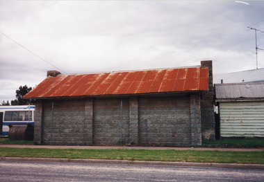 Lakes Entrance Historical Society
Photograph - Cricket, 1999
Concrete bricks formed pattern mould, made in shed at Kimmell's farm by Clyde Worseldine, WW2 returned service man, in employ of Tambo Shire.Colour photograph of a concrete brick afternoon-tea pavilion built 1946c for Lakes Entrance Cricket Club. Building has a chimney at each end and corrugated iron roof, sited flush of south fence of Recreation Reserve. Also in image small wooden shed which was moved from Post Office residence 1960c when Post Office was extended. Lakes Entrance Victoriasports, cricket, buildings