Showing 518 items
matching burke road
-
 Kew Historical Society Inc
Plan, Melbourne & Metropolitan Board of Works : Borough of Kew : Detail Plan No.1561, 1905
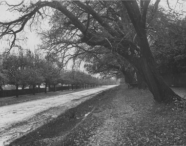
... bordered by Burke Road, Loxton Street, Mount Street and Barkers... residences in the area bordered by Burke Road, Loxton Street, Mount ...The Melbourne and Metropolitan Board of Works (MMBW) plans were produced from the 1890s to the 1950s. They were crucial to the design and development of Melbourne's sewerage and drainage system. The plans, at a scale of 40 feet to 1 inch (1:480), provide a detailed historical record of Melbourne streetscapes and environmental features. Each plan covers one or two street blocks (roughly six streets), showing details of buildings, including garden layouts and ownership boundaries, and features such as laneways, drains, bridges, parks, municipal boundaries and other prominent landmarks as they existed at the time each plan was produced. (Source: State Library of Victoria). This plan forms part of a large group of MMBW plans and maps that was donated to the Society by Mr Poulter, City Engineer of the City of Kew in 1989. Within this collection, thirty-five hand-coloured plans, backed with linen, are of statewide significance as they include annotations that provide details of construction materials used in buildings in the first decade of the 20th century as well as additional information about land ownership and usage. The copies in the Public Record Office Victoria and the State Library of Victoria are monochrome versions which do not denote building materials so that the maps in this collection are invaluable and unique tools for researchers and heritage consultants. A number of the plans are not held in the collection of the State Library of Victoria so they have the additional attribute of rarity.Original survey plan, issued by the MMBW to a contractor with responsibility for constructing sewers in the area identified on the plan within the Borough of Kew. The plan was at some stage hand-coloured, possibly by the contractor, but more likely by officers working in the Engineering Department of the Borough and later Town, then City of Kew. The hand-coloured sections of buildings on the plan were used to denote masonry or brick constructions (pink), weatherboard constructions (yellow), and public buildings (grey). MMBW Detail Plan 1561 outlines those residences in the area bordered by Burke Road, Loxton Street, Mount Street and Barkers Road that had been constructed by 1905 when the land was surveyed. At this time, the area nearest Burke Road had been subdivided and developed whereas the lands to the west were as yet undeveloped. The houses represented are not named on the Plan.melbourne and metropolitan board of works, detail plans, mmbw 1561, cartography -
 Kew Historical Society Inc
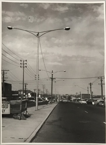
Photograph, Stuart Tompkins Studio, Electricity Supply Poles, Warrigal Road, Holmesglen, 1965
... , into alternatives for median strip street lighting to be used in Burke Road..., into alternatives for median strip street lighting to be used in Burke Road ...Research provided by Stuart Tompkins Studio, Box Hill, into alternatives for median strip street lighting to be used in Burke Road, Kew. The photographers identified variants in different suburbs appropriate to Kew's needs. The series from which the photograph is drawn provides a snapshot by a commercial photographic studio of each named vicinity in 1965 as well as providing examples of public works infrastructure being commissioned by local government in the 1960s. The photos originally formed part of the Engineering Department's files in the City of Kew before being donated to the kew Historical Society.Electricity Supply Poles, Warrigal Road, Holmesglen, 1965. Stuart Tompkins Studio provided this photograph for the Kew City Council. The photograph of Warrigal Road, north of Holmesglen looking north depicts wooden poles with bracket light fittings. These were the same as those proposed for Kew, except the lights and fittings were not to be 350 watt. Mercury lamps were preferred. [There are three copies of this photograph in the Collection.] Typed inscription on reverse: "Electricity Supply Poles. Photographed for Kew City Council 8/2/65. No.3 Warrigal Road - North of Holmesglen looking north. Wooden poles with bracket fittings same as those proposed for Kew except lights and fittings are not for 250 watt c. c. mercury lamps proposed. Wooden pole 3' up 11 3/4" dia." Studio stamp: "Stuart Tompkins Studio. 547 Station Street, Box Hill. WX1439."stuart tompkins studio, warrigal road (holmesglen) 1965, street lighting -
 Kew Historical Society Inc
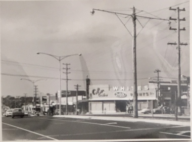
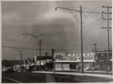
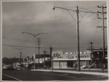
Photograph, Stuart Tompkins Studio, Electricity Supply Poles, South Road, Moorabbin, 1965
... , into alternatives for median strip street lighting to be used in Burke Road..., into alternatives for median strip street lighting to be used in Burke Road ...Research provided by Stuart Tompkins Studio, Box Hill, into alternatives for median strip street lighting to be used in Burke Road, Kew. The photographers identified variants in different suburbs appropriate to Kew's needs.The series from which the photograph is drawn provides a snapshot by a commercial photographic studio of each named vicinity in 1965 as well as providing examples of public works infrastructure being commissioned by local government in the 1960s. The photos originally formed part of the Engineering Department's files in the City of Kew before being donated to the kew Historical Society.Electricity Supply Poles, South Road, Moorabbin, 1965. Stuart Tompkins Studio provided this photograph for the Kew City Council. The photograph of South Road, Moorabbin, west of Jasper Road, looking east depicts steel poles with two lamps in a median strip and supply wires from pole to pole. The poles were described as 100′ apart. The notation on the rear of the photograph was that there were lamps along the median strip except at intersections. A wooden pole is recognised as supporting heavy supply lines across the road. The steel poles in the photograph were said to be between 3′ to 3.5′ whereas the wooden poles were three to 12.25″ in diameter. [There are three copies of this photograph in the Collection.] Typed inscription on reverse: "Electricity Supply Poles. Photographed for Kew City Council 8/2/65. No.2 South Road - Moorabbin, west of Jasper Road, looking east. Steel poles with two lamps in median strip and supply wires from pole to pole along median strip (poles only 100' apart). Lamps along median only except at intersections. Wooden pole supports heavy supply lines across the road. Wooden poles 3' up and 8 1/2" dia. Wooden poles 3' up and 12 1/2 dia." Studio stamp: "Stuart Tompkins Studio. 547 Station Street, Box Hill. WX1439."public infrastructure -- kew (vic.), city of kew - engineers department -
 Kew Historical Society Inc
Photograph, Stuart Tompkins Studio, Electricity Supply Poles, South Road, Moorabbin, 1965
... , into alternatives for median strip street lighting to be used in Burke Road..., into alternatives for median strip street lighting to be used in Burke Road ...Research provided by Stuart Tompkins Studio, Box Hill, into alternatives for median strip street lighting to be used in Burke Road, Kew. The photographers identified variants in different suburbs appropriate to Kew's needs.The series from which the photograph is drawn provides a snapshot by a commercial photographic studio of each named vicinity in 1965 as well as providing examples of public works infrastructure being commissioned by local government in the 1960s. The photos originally formed part of the Engineering Department's files in the City of Kew before being donated to the kew Historical Society.Electricity Supply Poles, South Road, Moorabbin, 1965. Stuart Tompkins Studio provided this photograph for the Kew City Council. The photograph of South Road, Moorabbin, west of Jasper Road, looking east depicts steel poles with two lamps in a median strip and supply wires from pole to pole. The poles were described as 100′ apart. The notation on the rear of the photograph was that there were lamps along the median strip except at intersections. A wooden pole is recognised as supporting heavy supply lines across the road. The steel poles in the photograph were said to be between 3′ to 3.5′ whereas the wooden poles were three to 12.25″ in diameter. [There are three copies of this photograph in the Collection.] Typed inscription on reverse: "Electricity Supply Poles. Photographed for Kew City Council 8/2/65. No.2 South Road - Moorabbin, west of Jasper Road, looking east. Steel poles with two lamps in median strip and supply wires from pole to pole along median strip (poles only 100' apart). Lamps along median only except at intersections. Wooden pole supports heavy supply lines across the road. Wooden poles 3' up and 8 1/2" dia. Wooden poles 3' up and 12 1/2 dia." Studio stamp: "Stuart Tompkins Studio. 547 Station Street, Box Hill. WX1439."city of kew -- engineers department, public infrastructure -- kew (vic.) -
 Kew Historical Society Inc
Photograph, Stuart Tompkins Studio, Electricity Supply Poles, South Road, Moorabbin, 1965
... , into alternatives for median strip street lighting to be used in Burke Road..., into alternatives for median strip street lighting to be used in Burke Road ...Research provided by Stuart Tompkins Studio, Box Hill, into alternatives for median strip street lighting to be used in Burke Road, Kew. The photographers identified variants in different suburbs appropriate to Kew's needs.The series from which the photograph is drawn provides a snapshot by a commercial photographic studio of each named vicinity in 1965 as well as providing examples of public works infrastructure being commissioned by local government in the 1960s. The photos originally formed part of the Engineering Department's files in the City of Kew before being donated to the kew Historical Society.Electricity Supply Poles, South Road, Moorabbin, 1965. Stuart Tompkins Studio provided this photograph for the Kew City Council. The photograph of South Road, Moorabbin, west of Jasper Road, looking east depicts steel poles with two lamps in a median strip and supply wires from pole to pole. The poles were described as 100′ apart. The notation on the rear of the photograph was that there were lamps along the median strip except at intersections. A wooden pole is recognised as supporting heavy supply lines across the road. The steel poles in the photograph were said to be between 3′ to 3.5′ whereas the wooden poles were three to 12.25″ in diameter. [There are three copies of this photograph in the Collection.] Typed inscription on reverse: "Electricity Supply Poles. Photographed for Kew City Council 8/2/65. No.2 South Road - Moorabbin, west of Jasper Road, looking east. Steel poles with two lamps in median strip and supply wires from pole to pole along median strip (poles only 100' apart). Lamps along median only except at intersections. Wooden pole supports heavy supply lines across the road. Wooden poles 3' up and 8 1/2" dia. Wooden poles 3' up and 12 1/2 dia." Studio stamp: "Stuart Tompkins Studio. 547 Station Street, Box Hill. WX1439."stuart tompkins studio, street lighting, south road (moorabin) 1965, public infrastructure -- city of kew, city of kew -- engineer's department -
 Kew Historical Society Inc
Photograph, Stuart Tompkins Studio, Electricity Supply Poles, Warrigal Road, Ashwood, 1965
... , into alternatives for median strip street lighting to be used in Burke Road..., into alternatives for median strip street lighting to be used in Burke Road ...Research provided by Stuart Tompkins Studio, Box Hill, into alternatives for median strip street lighting to be used in Burke Road, Kew. The photographers identified variants in different suburbs appropriate to Kew's needs.The series from which the photograph is drawn provides a snapshot by a commercial photographic studio of each named vicinity in 1965 as well as providing examples of public works infrastructure being commissioned by local government in the 1960s. The photos originally formed part of the Engineering Department's files in the City of Kew before being donated to the kew Historical Society.Electricity Supply Poles, Warrigal Road, Ashwood, 1965. Stuart Tompkins Studio provided this photograph for the Kew City Council. The photograph, taken at the intersection of Warrigal Road and High Street South, Ashwood looks north along High Street Road. The intent of the photograph was to provide the Council with models of electricity supply poles. In the photo, wooden and steel poles can be seen in the median strip. The photograph also includes the shops bordering High Street Road during this period. [There are three copies of this photograph in the Collection.]. Typed inscription on reverse: "Electricity Supply Poles. Photographed for Kew City Council 8/2/65. No.4 Warrigal Road - Ashwood. South of High Street Road looking north. Wooden and steel poles with different brackets in median strip." Studio stamp: "Stuart Tompkins Studio. 547 Station Street, Box Hill. WX1439."electric light poles, public works -- 1960s, civic infrastructure -- 1960s -
 Kew Historical Society Inc
Photograph, Stuart Tompkins Studio, Electricity Supply Poles, Warrigal Road, Ashwood, 1965
... , into alternatives for median strip street lighting to be used in Burke Road..., into alternatives for median strip street lighting to be used in Burke Road ...Research provided by Stuart Tompkins Studio, Box Hill, into alternatives for median strip street lighting to be used in Burke Road, Kew. The photographers identified variants in different suburbs appropriate to Kew's needs.The series from which the photograph is drawn provides a snapshot by a commercial photographic studio of each named vicinity in 1965 as well as providing examples of public works infrastructure being commissioned by local government in the 1960s. The photos originally formed part of the Engineering Department's files in the City of Kew before being donated to the kew Historical Society.Electricity Supply Poles, Warrigal Road, Ashwood, 1965. Stuart Tompkins Studio provided this photograph for the Kew City Council. The photograph, taken at the intersection of Warrigal Road and High Street South, Ashwood looks north along High Street Road. The intent of the photograph was to provide the Council with models of electricity supply poles. In the photo, wooden and steel poles can be seen in the median strip. The photograph also includes the shops bordering High Street Road during this period. [There are three copies of this photograph in the Collection.]. Typed inscription on reverse: "Electricity Supply Poles. Photographed for Kew City Council 8/2/65. No.4 Warrigal Road - Ashwood. South of High Street Road looking north. Wooden and steel poles with different brackets in median strip." Studio stamp: "Stuart Tompkins Studio. 547 Station Street, Box Hill. WX1439."electric light poles, civic infrastructure - 1960s, public works -- 1960s -
 Kew Historical Society Inc
Photograph, Stuart Tompkins Studio, Electricity Supply Poles, Warrigal Road, Ashwood, 1965
... , into alternatives for median strip street lighting to be used in Burke Road..., into alternatives for median strip street lighting to be used in Burke Road ...Research provided by Stuart Tompkins Studio, Box Hill, into alternatives for median strip street lighting to be used in Burke Road, Kew. The photographers identified variants in different suburbs appropriate to Kew's needs.The series from which the photograph is drawn provides a snapshot by a commercial photographic studio of each named vicinity in 1965 as well as providing examples of public works infrastructure being commissioned by local government in the 1960s. The photos originally formed part of the Engineering Department's files in the City of Kew before being donated to the kew Historical Society.Electricity Supply Poles, Warrigal Road, Ashwood, 1965. Stuart Tompkins Studio provided this photograph for the Kew City Council. The photograph, taken at the intersection of Warrigal Road and High Street South, Ashwood looks north along High Street Road. The intent of the photograph was to provide the Council with models of electricity supply poles. In the photo, wooden and steel poles can be seen in the median strip. The photograph also includes the shops bordering High Street Road during this period. [There are three copies of this photograph in the Collection.]. Typed inscription on reverse: "Electricity Supply Poles. Photographed for Kew City Council 8/2/65. No.4 Warrigal Road - Ashwood. South of High Street Road looking north. Wooden and steel poles with different brackets in median strip." Studio stamp: "Stuart Tompkins Studio. 547 Station Street, Box Hill. WX1439."electric light poles, public infrastructure -- 1960s, civic works -- 1960s -
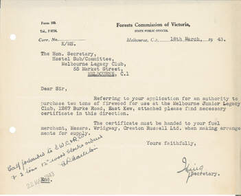 Melbourne Legacy
Letter - Document, letter, 18/03/1943
... to purchase two tons of firewood for use at Holmbush at 1267 Burke... to purchase two tons of firewood for use at Holmbush at 1267 Burke ...Approval received from the Forests Commission of Victoria to purchase two tons of firewood for use at Holmbush at 1267 Burke Road. It shows that wood was a rationed resource during the war and approval was required from the Forest Commission before acquisition. A record that purchase of firewood required approval in 1943.Letter on Forest Commission Victoria letterhead about acquiring firewood, white paper with black type, two hole punched.Signed illegible for Secretary of Forests Commission of Victoriaholmbush administration, holmbush -
 Camberwell Girls Grammar School
Biographical, Sir [Henry] Cecil Colville
... "Arden" at 1045 Burke Road East Hawthorn [on the corner... in 1925. The family home "Arden" at 1045 Burke Road East Hawthorn ...Sir Cecil Colville was awarded a knighthood in 1962. He was previously known as Dr H.C. Colville and was a member of the School Council from approximately 1924-1938. His daughters Peg [Elaine Margaret] Colville and Anne Colville attended CGGS while the school was located at St Mark's Church and at the current day location of Torrington Street, Canterbury from 1928. Peg Colville enrolled in 1922 and her sister Anne enrolled in 1925. The family home "Arden" at 1045 Burke Road East Hawthorn [on the corner of Rathmines Road and Burke Road] was demolished in 2016 which included a garden designed by Edna Walling in 1928. -
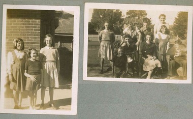 Melbourne Legacy
Photograph, Holmbush residents, 194X
... . Holmbush at 1267 Burke road, was one of the properties that Legacy... at 1267 Burke road, was one of the properties that Legacy used ...Photo of some of the children that lived at Holmbush. The names are not known. Some are seen in other photos in the album. Holmbush at 1267 Burke road, was one of the properties that Legacy used for Junior Legatees. It was purchased 1942. In 1957 Holmbush was renamed Blamey House until it was sold in 1977.A compilation of photos of some junior legatees in the Legacy residences.Black and white photo x 2 of children posing at Holmbush pasted to the pages of an album.residences, holmbush, junior legatees -
 Melbourne Legacy
Photograph, Holmbush residents, 194X
... . Holmbush at 1267 Burke road, was one of the properties that Legacy... at 1267 Burke road, was one of the properties that Legacy used ...Photo of one of the children that lived at Holmbush. The name is not known. She is seen in other photos in the album. Holmbush at 1267 Burke road, was one of the properties that Legacy used for Junior Legatees. It was purchased 1942. In 1957 Holmbush was renamed Blamey House until it was sold in 1977.A compilation of photos of some junior legatees in the Legacy residences.Black and white photo a girl posing at Holmbush pasted to the pages of an album.residences, holmbush, junior legatees -
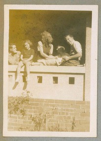 Melbourne Legacy
Photograph, Holmbush residents, 194X
... . Holmbush at 1267 Burke road, was one of the properties that Legacy... at 1267 Burke road, was one of the properties that Legacy used ...Photo of five people that lived at Holmbush. The other names are not known. Some are seen in other photos in the album. Holmbush at 1267 Burke road, was one of the properties that Legacy used for Junior Legatees. It was purchased 1942. In 1957 Holmbush was renamed Blamey House until it was sold in 1977.A compilation of photos of some junior legatees in the Legacy residences.Black and white photo of 5 residents posing on the balcony at Holmbush pasted to the pages of an album.residences, holmbush, junior legatees -
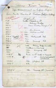 Melbourne Tram Museum
Document - Research Notes, Mr. Mainwaring, PMTT surface slopes, 1910
... tree Road to Burke Road. Prepared by Mr Mainwaring in black... tree Road to Burke Road. Prepared by Mr Mainwaring in black ...Three ruled foolscap sheets, tied in the top left hand corner with string, headed Prahran Malvern Tramways - tape measurement of surface slopes from High Street, Glenferrie Road Wattle tree Road to Burke Road. Prepared by Mr Mainwaring in black and red ink. Dated 30.6.1910. Items 2041 to 2052 within box 72.3 in a brown folder marked "PMTT" in red pencil.trams, tramways, pmtt, malvern, surveys, high st, wattle tree rd, burke rd -
 Melbourne Tram Museum
Slide, Keith Caldwell, March 1968?
... Burke Road, during the construction phase of diverting... Burke Road, during the construction phase of diverting ...Agfa colour blue white plastic mount, photo by Keith Caldwell of W2 455 outbound in Dandenong Road, route 5, Malvern Burke Road, during the construction phase of diverting Wellington St Prahran into Queensway. Slide not dated. Work to divert Dandenong Road completed Jan. 1968 (Timeline book). Photo possibly March 1968, which would match with the information on Reg Item 4313.trams, tramways, dandenong rd, route 5, malvern burke rd, w2 class, tram 455 -
 Melbourne Tram Museum
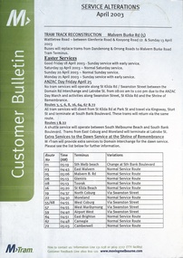
Poster, M>Tram, "Service Alterations", April 2003
... in Malvern Burke Road, Easter, and Anzac Day services. Details... in Malvern Burke Road, Easter, and Anzac Day services. Details ...Poster titled "Service Alterations", produced by M>Tram, for April 2003, detailing the changes for tram track reconstruction in Malvern Burke Road, Easter, and Anzac Day services. Details the extra services for the Dawn service and route changes. Has the M>Tram logos, with contact details.Demonstrates a M>Tram Customer Bulletin.Poster printed on off white heavy A3 size paper. trams, tramways, m>tram, timetables, melbourne, information, service changes -
 Kew Historical Society Inc
Plan - Subdivision Plan, Oswinia Estate, East Kew, c.1925
... , Burke Road and the Government Boulevard (later Kilby Road..., Burke Road and the Government Boulevard (later Kilby Road ...Prue Sanderson, in her groundbreaking ‘City of Kew Urban Conservation Study : Volume 2 - Development History’ (1988), summarised the periods of urban development and subdivisions of land in Kew. The periods that she identified included 1845-1880, 1880-1893, 1893-1921, 1921-1933, 1933-1943, and Post-War Development. These periods were selected as they represented periods of rapid growth or decline in urban development. An obvious starting point for Sanderson’s groupings involved population growth and the associated economic cycles. These cycles also highlighted urban expansion onto land that was predominantly rural, although in other cases it represented the decline and breakup of large estates. A number of the plans in the Kew Historical Society’s collection can also be found in other collections, such as those of the State Library of Victoria and the Boroondara Library Service. A number are however unique to the collection.Subdivision plans are historically important documents used as evidence of the growth of suburbs in Australia. They frequently provide information about when the land was sold on which a built structure was subsequently constructed as well as evidence relating to surveyors and real estate and financial agents. The numerous subdivision plans in the Kew Historical Society's collection represent working documents, ranging from the initial sketches made in planning a subdivision to printed plans on which auctioneers or agents listed the prices for which individual lots were sold. In a number of cases, the reverse of a subdivision plan in the collection includes a photograph of a house that was also for sale by the agent. These photographs provide significant heritage information relating house design and decoration, fencing and household gardens.The ‘Oswinia Estate’ subdivision in East Kew was planned and auctioned in the first half of the 1920s. 169 allotments were created in the triangular section of land bordered by High Street, Burke Road and the Government Boulevard (later Kilby Road). The only piece of land excluded was that where the previous Kew Pound had been located at the east tip of the triangle. Allotments were created fronting Glass, High, Namur, Oswin Streets, Irymple Avenue, and the Government Boulevard. The name for the Estate was derived from Oswin’s farm, which had been one of the largest landholdings in East Kew. The selling agents annotated the plan in our collection with crosses indicating those lots that had been sold. The inset locality plan is particularly interesting as it shows the route and stations of the Outer Circle Railway. When the subdivision plan was created, it included the proposed bridge over the Yarra at Burke Road. The bridge was to be officially opened in 1926.subdivision plans - east kew, oswinia estate, high street, glass street, namur street, government boulevard - kilby road, irymple street, oswin street -
 Melbourne Legacy
Photograph, Holmbush residents, 194X
... are not known. Holmbush at 1267 Burke road, was one of the properties.... Holmbush at 1267 Burke road, was one of the properties that Legacy ...Photo of a girl who lived at Holmbush - she is also in 02341. The other photo shows three children. The names are not known. Holmbush at 1267 Burke road, was one of the properties that Legacy used for Junior Legatees. It was purchased 1942. In 1957 Holmbush was renamed Blamey House until it was sold in 1977.A compilation of photos of some junior legatees in the Legacy residences.Black and white photo x 2 of children posing at Holmbush pasted to the pages of an album.residences, holmbush, junior legatees -
 Ballarat Tramway Museum
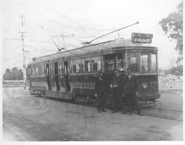
Photograph - Digital image, late 1910's
... Traction tramcar No. 35 at Burke Road, late 1910's. Tram later... at Burke Road, late 1910's. Tram later became Ballarat No. 40. Tram ...Yields information about a PMTT tramcar that was sold to Ballarat and an operating member of the BTM fleet. Yields information about uniforms.Digital Image of Prahran and Malvern Tramway Trust, Maximum Traction tramcar No. 35 at Burke Road, late 1910's. Tram later became Ballarat No. 40. Tram has the destination of St Kilda, and has three crew members in uniform standing in front of the tram. Driver on the left hold handles, Conductor in the middle - with a conductors jacket lapel badges and the man on the right, with a cash bag, but not in full uniform - a trainee?trams, tramways, pmtt, st kilda, maximum traction, tram 35, tram 40 -
 Kew Historical Society Inc
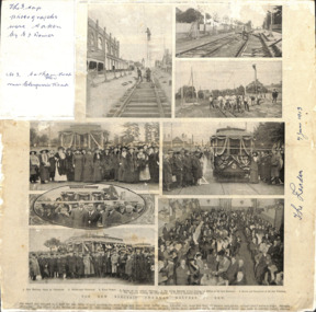
Article, The New Electric Tramway, Malvern to Kew
... photos are: 1. Kew Railway Gates at Glenferrie. 2. Burke Road... photographs were taken by E J Dower. No.3 Cotham Road Kew near ...One of a group of photographs, including three within a published photo collage , taken by Edgar James Dower in the second decade of the twentieth century. Born and raised in Olinda, Dower later moved to Surrey Hills. He worked as an adult as a clerk in the city office of the Metropolitan Gas Company, and in his role as a 'collector', he was able to photograph scenes including the construction of tramlines, railways and associated buildings in Kew, Hawthorn, Camberwell and Surrey Hills. Later he established a real estate agency with his brother - the E.J. Dower Real Estate Agency, Mount Dandenong Office.The photo collage is an historically significant record of the development of transport infrastructure which was used to connect Victorians in the first two decades of the twentieth century. This development resulted from increases in population and the consequent extension of Melbourne's suburbs. The photographs, both individually and collectively, richly detail the labour of workers and the tools and machinery used to create and extend Melbourne's public transport network in the years preceding and during World War 1.Photo collage, published in The Leader newspaper in 1913, to commemorate the opening of the Malvern to Kew Tramway. The numbered photos are: 1. Kew Railway Gates at Glenferrie. 2. Burke Road Terminus. 3. Final Stages. 4. Ladies at the Official Opening. 5. The Acting Mayoress of Kew Cutting the Ribbon at the Kew Boundary. 6. Mayor and Councillors at the Kew Terminus. 7. The Cutting the First Ribbon. 8. Guests at the Hawthorn Town Hall.Inscribed in ink by Edgar J Dower top left: "The 3 top photographs were taken by E J Dower. No.3 Cotham Road Kew near Glenferrie Road"theme -- connecting victorians by transport and communications, theme -- travelling by tram -
 Melbourne Legacy
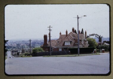
Slide, Harelands, 1950s
... day from across Burke Road. Harelands was at 5 Willesmere Road... from across Burke Road. Harelands was at 5 Willesmere Road ...Slide photograph of the exterior of Harelands on a cloudy day from across Burke Road. Harelands was at 5 Willesmere Road on the corner with Burke Road. Harelands was a residence run by Melbourne Legacy to take care of children whose fathers were deceased servicemen, and who may have been left orphans, or whose mother may have been unable to care for them herself, or they needed to stay in Melbourne for education. Harelands generally looked after children up to the age of 14. Boys then moved to Blamey House and girls went to Stanhope. Harelands was built in the Queen Anne style and is now heritage listed. The slides have been photographed to make digital images and moved to archive quality sleeves. In many cases the original images were not well focussed and the digital image is the best available.A record of the outside of Harelands.Colour slide of the exterior of Harelands, in a brown cardboard mount.Handwritten on front 'Harelands' in blue pen.residences, harelands -
 Melbourne Legacy
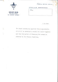
Document - Memorandum, Establishing hostels for Junior Legatees, 01/10/1942
... , Stanhope (1245 Burke Road). Residents of Holmbush and other Legacy..., Stanhope (1245 Burke Road). Residents of Holmbush and other Legacy ...An inter-club memorandum advising of the Board's approval to establish a hostel for Junior Legatees, later to be known as Holmbush, and ultimately as Blamey House. Holmbush was the first residential accommodation operated by Melbourne Legacy, and was established in 1942. It accommodated boys aged between 9 and 19, usually attending secondary school. In 1956, Holmbush became known as Blamey House. It was located not far from another Legacy home, Stanhope (1245 Burke Road). Residents of Holmbush and other Legacy homes were the children of deceased ex-servicemen. Sometimes residents at Legacy homes were both children of ex-servicemen and wards of state. In 1956, Blamey House, another Legacy children's home formerly in Beaumaris moved into the Holmbush property in Kew, and it was renamed Blamey House. Location 1942 - 1956? Address - Holmbush was located at 1267 Burke Road, Kew. Location: Kew Early record of the establishment of one of Melbourne Legacy's residences.Typed memo, black on white with blue letterhead outlining the agreement of the JLC board to proceed with the hostel for boys.residences, holmbush initial negotiations -
 Melbourne Tram Museum
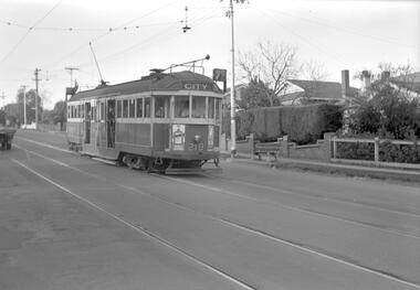
Negative, Travis Jeffrey, c1963
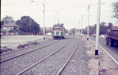
... that indicated the type of stops at night. Possibly in Burke Road.... Possibly in Burke Road, between Leura Grove and Toorak Road ...Negative of tram 219 at a tram stop. Tram has destination City and Route No 7. Photo looks staged as a school child in uniform leaning at door, driver and passenger in front window are all staring at the photographer. Note the tram has a trolley wheel fitted, the stop is a compulsory stop and that there is a light fitting above the tram with a tinted glass shield that indicated the type of stops at night. Possibly in Burke Road, between Leura Grove and Toorak Road.Paper folder that contained the negative had "NR99A" in red ink, "M5" in pencil, 58A in green ink, date stamp "1 Jan 1963" on front, and date stamp on rear "26 Sep 1962".trams, tramways, w2 class, route 7, tram stops, burke rd, tram 219 -
 The Beechworth Burke Museum
Photograph
... and civic pride. beechworth acacia avenue gaol sydney road burke ...This photograph was taken of an avenuw of acacias on Sydney Rd, Beechworth. Picture on the left hand-side is a row of Liquidamber trees also known as American storax, hazel pine, bilsted, redgum, satin-walnut, star-leaved gum, alligatorwood, or simply sweetgum. On the right is a row of English Oak trees commonly known as common oak, pedunculate oak, or European oak. Behind the English oaks is Old Beechworth Goal. Many of the trees in the Beechworth township were planted in the 1860's and today have exceptional historical, botanical or cultural value. Their place within the built environment reflects the importance in the Victorian era of town planning for a community, wealthy in gold and civic pride.Black and white rectangular photograph. The image is printed on gloss photographic paper and mounted on cardboard. Obverse: NO INSCRIPTION Reverse: 7760 The old Acacia Avenue alongside the jail. Sydney Road Beechworth Gardens & Parks beechworth, acacia avenue, gaol, sydney road, burke museum, photograph, post card, english oak, liquidambar -
 Melbourne Legacy
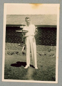
Article, Bulletin VALE Robert Wight - Supervisor Blamey House, 1977
... in Blamey House at 1267 Burke Road from June 1964. The article... in Blamey House at 1267 Burke Road from June 1964. The article ...A Vale article that was published in the Bulletin in 1977 on the death of Mr Robert Alfred (Bob) Wight who had been the supervisor of Blamey House for 13 years. Bob Wight with his wife Jane Wight as Assistant Superintendent, looked after the boys in Blamey House at 1267 Burke Road from June 1964. The article includes some details of their lives. A record of the life of a long term staff member.White A4 paper photocopy from the Bulletin of an article on the death of Supervisor Bob Wight.vale, bob wight, jane wight, blamey house -
 Melbourne Legacy
Photograph, Holmbush residents, 194X
... . Holmbush at 1267 Burke road, was one of the properties that Legacy.... Holmbush at 1267 Burke road, was one of the properties that Legacy ...Photo of a young man that lived at Holmbush, he appears to be holding two trophies and may be wearing white cricket uniform. The name is not known. He is seen in other photos in the album. Holmbush at 1267 Burke road, was one of the properties that Legacy used for Junior Legatees. It was purchased 1942. In 1957 Holmbush was renamed Blamey House until it was sold in 1977.A compilation of photos of some junior legatees in the Legacy residences.Black and white photo of a young man posing with his trophies at Holmbush pasted to the pages of an album.residences, holmbush, junior legatees -
 Kew Historical Society Inc
Plan - Subdivision Plan, Shop Sites, East Kew, c.1927
... and Lambert’s Store. The High Street Tram was to reach Burke Road... and Lambert’s Store. The High Street Tram was to reach Burke Road ...Subdivision plans are historically important documents used as evidence of the growth of suburbs in Australia. They frequently provide information about when the land was sold on which a built structure was subsequently constructed as well as evidence relating to surveyors and real estate and financial agents. The numerous subdivision plans in the Kew Historical Society's collection represent working documents, ranging from the initial sketches made in planning a subdivision to printed plans on which auctioneers or agents listed the prices for which individual lots were sold. In a number of cases, the reverse of a subdivision plan in the collection includes a photograph of a house that was also for sale by the agent. These photographs provide significant heritage information relating house design and decoration, fencing and household gardens.This is one of a small number of subdivision plans for commercial property in the collection. The subdivision proposed to create six shop sites in High Street between the Harp of Erin and Station Street. The plan shows this stretch of High Street, East Kew already lined with shops that include the hotel on the corner, the new State Savings Bank, a dentist’s surgery and Lambert’s Store. The High Street Tram was to reach Burke Road in 1925, so the proposed subdivision must postdate that event, and the opening of the Bank in 1926.subdivision plans - east kew, high street - east kew -
 Kew Historical Society Inc
Plan - Subdivision Plan, Mont Victor Hill Estate, 1936
... in Victor Avenue, Heather Grove and Burke Road. Bisecting the Estate... and Burke Road. Bisecting the Estate and clearly marked on the plan ...Pru Sanderson, in her groundbreaking ‘City of Kew Urban Conservation Study : Volume 2 - Development History’ (1988), summarised the periods of urban development and subdivisions of land in Kew. The periods that she identified included 1845-1880, 1880-1893, 1893-1921, 1921-1933, 1933-1943, and Post-War Development. These periods were selected as they represented periods of rapid growth or decline in urban development. An obvious starting point for Sanderson’s groupings involved population growth and the associated economic cycles. These cycles also highlighted urban expansion onto land that was predominantly rural, although in other cases it represented the decline and breakup of large estates. A number of the plans in the Kew Historical Society’s collection can also be found in other collections, such as those of the State Library of Victoria and the Boroondara Library Service. A number are however unique to the collection.Subdivision plans are historically important documents used as evidence of the growth of suburbs in Australia. They frequently provide information about when the land was sold on which a built structure was subsequently constructed as well as evidence relating to surveyors and real estate and financial agents. The numerous subdivision plans in the Kew Historical Society's collection represent working documents, ranging from the initial sketches made in planning a subdivision to printed plans on which auctioneers or agents listed the prices for which individual lots were sold. In a number of cases, the reverse of a subdivision plan in the collection includes a photograph of a house that was also for sale by the agent. These photographs provide significant heritage information relating house design and decoration, fencing and household gardens.A preliminary plan for the Mont Victor Hill subdivision of 1936 which included 23 allotments bordering the Rimington Nursery in Mont Victor Road. The subdivision created allotments in Victor Avenue, Heather Grove and Burke Road. Bisecting the Estate and clearly marked on the plan is the Railway Reserve which at this stage was all that remained of the Outer Circle Railway. The auctioneers note on the plan that the subdivision was made possible by the order of Messrs S. H. Bennet & H. Wright, the executors of the Wills of S. Bennett & E. Foreman.mont victor hill estate, subdivision plans - kew -
 Kew Historical Society Inc
Map, MMBW, MMBW Plan No.66 Kew, 1900-1910
... by Burke Road. The map shows the extent of urban development... Road, and in the east by Burke Road. The map shows the extent ...The Melbourne and Metropolitan Board of Works (MMBW) was established by an act of the Victorian Parliament in 1890 to prepare for and to implement a sewerage and water reticulation system across what was then inner Melbourne, its surrounding and middle distance suburbs, including Kew. The MMBW was disbanded in 1991.The map collection of the Kew Historical Society has at its core the historic maps assembled and originally stored in the City Engineer's Department of the City of Kew. These include maps in a number of scales. The vast majority of maps were produced by the MMBW in the first two decades of the twentieth century, and are solid working maps, backed by linen for durability. These maps are historically significant to Kew, the City of Boroondara and to the history of the development of state utilities in Victoria. A number of the Kew maps have additional details added by former municipal officers, including the levels reached by various floods. As these were working documents, information was added to them long after the period of their initial production and distribution.Early map of part of the Borough of Kew, created in the first decade of the twentieth century, at a scale 160 ft to 1 inch. The map covers what was then the south eastern part of Kew, bordered on its north by Adeney Avenue, in the west by Sackville Street, in the south by Barkers Road, and in the east by Burke Road. The map shows the extent of urban development by that time, prominent institutions and the outlines of built structures in the municipality. Contour lines were added in ink to the map at a later stage.MELBOURNE AND METROPOLITAN BOARD OF WORKS / PLAN NO. 66 / KEW melbourne & metropolitan board of works, mmbw maps, mmbw plans, borough of kew, cartography