Showing 486 items
matching kilometres
-
 Greensborough Historical Society
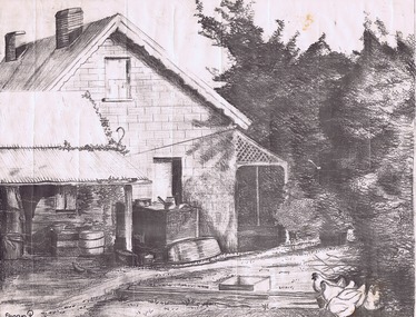
Drawing, Willis Vale by Sharyn Partington, 1983_
Drawn in 1983 by Sharyn Partington (age 15). Sharyn is the daughter of Trevor and granddaughter of Alan and Wyn Partington. The artwork would have been drawn from photos of the Partington home. The derelict Willis Vale house was vandalized in 1964 destroyed when a fire originating from North Plenty Gorge - Kurrak Road - was lit by two teenage boys and made its way several kilometres down to Partington's Flat Greensborough.An original artwork of the Partington home created by a descendant of the occupants.Pencil drawing on cream art paper. Depicts a view of Willis Vale. In black frame under glass.Signed "Sharyn P. 1983"partington, sharyn partington, willis vale, greensborough -
 Warrnambool and District Historical Society Inc.
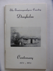
Booklet, The Temiangandeen Country Dergholm, 1973
This booklet gives information on the settlement of Dergholm at the time of the centenary of its founding, 1973. The origin of the name Dergholm is unclear but it may have Irish connections. Europeans came to the area in the 1840s and 50s but it was not until the 1870s that the town was surveyed. Dergholm is in the far west of Victoria 334 kilometres from Melbourne and nearby is Dergholm State Park established in 1982. The booklet was produced for the Centenary Back to Dergholm Committee and the local centenary celebrations. This book is of some interest as it provides information on Dergholm, a settlement in the far west of Western Victoria. This is a soft cover booklet of 52 pages by Alistair Roper. It has a cream-coloured cover with a black and white photograph of early Dergholm on the front cover (Edward Quinn’s house). The booklet has printed material - a President’s Message, an Author’s Note, Acknowledgements, Contents, information on the Dergholm area, including a list of local birds, and References. There are several black and white photographs of the area and its people. The book is stapled. Front Cover: ‘The Temiangandgeen Country, Dergholm Centenary, 1873-1973’dergholm victoria, alistair roper, history of western district of victoria -
 Ballarat Heritage Services
Photograph - Colour, Clare Gervasoni, Fawcett Hall and Public Library, 2015, 11/01//2015
Fawcett Hall is 14 kilometres North West of Alexandra, North East Victoria, in Spring Creek Road and is set amongst a small picturesque rural farming and business community with hills as a backdrop and Stony Creek running alongside the public reserves property boundary. Part of our hall building dates back to its establishment in 1882. Originally the hall served as a Mechanics Institute and Public Library and later as a primary school.Colour photograph of a weatherboard Hall.fawcett hall and public library, fawcett, fawcett mechanics' institute -
 City of Greater Bendigo - Civic Collection
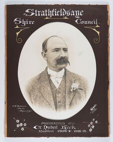
Photograph - Portrait of Councillor Keck, W H Robinson, c 1913
The district of Strathfieldsaye was proclaimed in 1861 and named a Shire on the 17th September in 1866. It remained a shire until amalgamation in 1994 when it became part of the City of Greater Bendigo. The shire was located 8 km to the south- east of Bendigo and covered an area of 601 square kilometres and extended from the Calder Highway to the Coliban and Campaspe Rivers. The shire's administration centre was in Strathfieldsaye until 1972 when new offices were opened in Kennington.Framed black and white head and shoulder portrait of Councillor Keck with hand coloured and drawn detail. Profile slightly to right with walrus moustache. Cut oval brown mount decorated with text and flowers. Hand written title top and lower centre.Strathfieldsaye / Shire Council / W.H. Robinson / Photo / Bendigo / J.H.E Gribbs / Presented by / Cr Herbert Keck / President 1903-4. 1912-13.shire of strathfieldsaye, councillor keck, strathfieldsaye shire council, president of strathfieldsaye shire -
 City of Greater Bendigo - Civic Collection
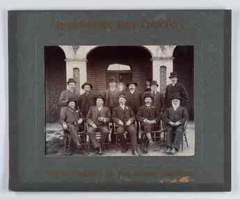
Photograph - Councillor group portrait, W H Robinson, Strathfieldsaye Shire Council, 1909
The district of Strathfieldsaye was proclaimed in 1861 and named a Shire on the 17th September in 1866. It remained a shire until amalgamation in 1994 when it became part of the City of Greater Bendigo. The shire was located 8 km to the south- east of Bendigo and covered an area of 601 square kilometres and extended from the Calder Highway to the Coliban and Campaspe Rivers. The shire's administration centre was in Strathfieldsaye until 1972 when new offices were opened in Kennington.Photographic group portrait of eleven Strathfieldsaye Shire Councillors in front of the Strathfieldsaye Shire Hall. Five men are seated and six standing with one man standing further in back ground on the building's verandah. Photograph is attached directly to green mount card and framed. Gold lettering on mount.Strathfieldsaye Shire Councillors / R. B. Brennan (Sec.) W. J. Lowdes S. Doak M. Burns () N Condon B. Code (Inspector) / WH Robinson Photo Bendigo / T Somerville / W. I. Long / Fred Osborne (President) H Keck / W Dresler / With the President's (Cr. Fred Osborne) Compliments / September 23rd, 1909shire of strathfieldsaye, strathfieldsaye shire council, president of strathfieldsaye shire, strathfieldsaye shire hall -
 City of Greater Bendigo - Civic Collection
Photograph - Councillor group portrait, W H Robinson, Strathfieldsaye Shire Council
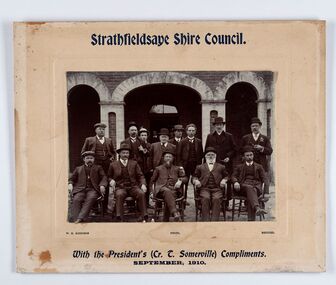
The district of Strathfieldsaye was proclaimed in 1861 and named a Shire on the 17th September in 1866. It remained a shire until amalgamation in 1994 when it became part of the City of Greater Bendigo. The shire was located 8 km to the south- east of Bendigo and covered an area of 601 square kilometres and extended from the Calder Highway to the Coliban and Campaspe Rivers. The shire's administration centre was in Strathfieldsaye until 1972 when new offices were opened in Kennington. Group portrait of 13 men / councilors, 5 seated and 8 standing dressed in suits. There are another 2 men further back in front of the hall doors. Photograph is taken outside the Strathfieldsaye Shire Hall.Srathfieldsaye Shire Council. / With the President's (Cr T. Somerville) Compliments. / September, 1910 / W.H. Robinson Photo. Bendigo Verso; William Drechslershire of strathfieldsaye, president of strathfieldsaye shire, strathfieldsaye shire council -
 City of Greater Bendigo - Civic Collection
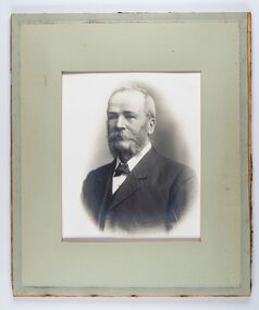
Photograph - Portrait of Councillor Burke
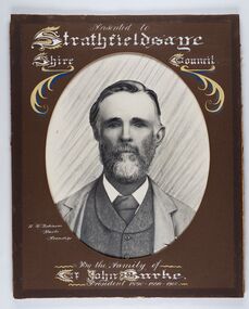
The district of Strathfieldsaye was proclaimed in 1861 and named a Shire on the 17th September in 1866. It remained a shire until amalgamation in 1994 when it became part of the City of Greater Bendigo. The shire was located 8 km to the south- east of Bendigo and covered an area of 601 square kilometres and extended from the Calder Highway to the Coliban and Campaspe Rivers. The shire's administration centre was in Strathfieldsaye until 1972 when new offices were opened in Kennington. Framed black and white head and shoulder portrait of Councillor Burke with hand coloured and drawn detail. Profile centre facing with beard. Cut oval brown mount decorated with text and fscrolls. Hand written title top and lower centre. Wooden frame with detail and gold inner.Presented to Strathfieldsaye / shire Council / w. H. robinson / Photo / Bendigo / By the family of / Cr John Burke / President 1890 - 1899 - 1900strathfieldsaye shire council, councillor burke, president of strathfieldsaye shire -
 City of Greater Bendigo - Civic Collection
Photograph - Portrait of Councillor Thomas Somerville, W H Robinson
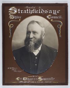
The district of Strathfieldsaye was proclaimed in 1861 and named a Shire on the 17th September in 1866. It remained a shire until amalgamation in 1994 when it became part of the City of Greater Bendigo. The shire was located 8 km to the south- east of Bendigo and covered an area of 601 square kilometres and extended from the Calder Highway to the Coliban and Campaspe Rivers. The shire's administration centre was in Strathfieldsaye until 1972 when new offices were opened in KenningtonFramed black and white head and shoulder portrait of Councillor Somerville with hand drawn detail. Profile slightly to left, face has full beard. Cut oval brown mount decorated with text and scrolls. Hand written title top and lower centre.Presented to / Strathfieldsaye / Shire Council / W. H. Robinson / Photo / Bendigo / by / Cr Thomas Somerville / President 1892 - 3. 1901.2. 1910.11 strathfieldsaye shire council, councillor somerville, president of strathfieldsaye shire -
 City of Greater Bendigo - Civic Collection
Photograph - Portrait of Councillor Michael Condon, W H Robinson
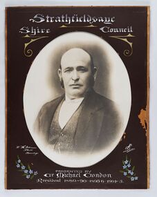
The district of Strathfieldsaye was proclaimed in 1861 and named a Shire on the 17th September in 1866. It remained a shire until amalgamation in 1994 when it became part of the City of Greater Bendigo. The shire was located 8 km to the south- east of Bendigo and covered an area of 601 square kilometres and extended from the Calder Highway to the Coliban and Campaspe Rivers. The shire's administration centre was in Strathfieldsaye until 1972 when new offices were opened in KenningtonFramed black and white head and shoulder portrait of Councillor Condon with hand coloured and drawn detail. Profile slightly to left. No facial hair. Cut oval brown mount decorated with text, scrolls and flowers. Hand written title top and lower centre.Strathfieldsaye / Shire / Council / W. H. Robinson / Photo / Bendigo / JMB Gribble / Presented by / Cr Michael Condon / President 1889 - 90. 1895-6. 1904 - 5strathfieldsaye shire council, president of strathfieldsaye shire, councillor condon -
 City of Greater Bendigo - Civic Collection
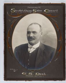
Photograph - Portrait of Councillor Doak, W H Robinson
The district of Strathfieldsaye was proclaimed in 1861 and named a Shire on the 17th September in 1866. It remained a shire until amalgamation in 1994 when it became part of the City of Greater Bendigo. The shire was located 8 km to the south- east of Bendigo and covered an area of 601 square kilometres and extended from the Calder Highway to the Coliban and Campaspe Rivers. The shire's administration centre was in Strathfieldsaye until 1972 when new offices were opened in Kennington.Framed black and white head and shoulder portrait of Councillor Doak with hand coloured and drawn detail. Left facing profile with walrus moustache. Cut oval brown mount decorated with text and scrolls. Hand written title top and lower centre.Presented to / Strathfieldsaye Shire Council / W. H. Robinson / Photo / JMB Gribble / by Cr S. Doak / President 1911 - 1912strathfieldsaye shire council, president of strathfieldsaye shire, councillor doak -
 City of Greater Bendigo - Civic Collection
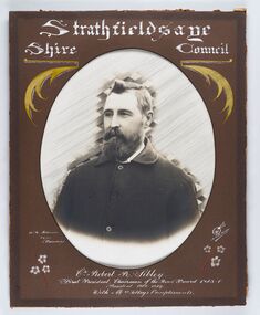
Photograph - Portrait of Councillor Sibley, W H Robinson
The district of Strathfieldsaye was proclaimed in 1861 and named a Shire on the 17th September in 1866. It remained a shire until amalgamation in 1994 when it became part of the City of Greater Bendigo. The shire was located 8 km to the south- east of Bendigo and covered an area of 601 square kilometres and extended from the Calder Highway to the Coliban and Campaspe Rivers. The shire's administration centre was in Strathfieldsaye until 1972 when new offices were opened in KenningtonFramed black and white head and shoulder portrait of Councillor Sibley with hand coloured and drawn detail. Profile slightly to left with walrus moustache and beard. Cut oval brown mount decorated with text, flowers and scrolls. Hand written title top and lower centre.Strathfieldsaye / Shire Council / W m Robinson / Photo / Bendigo / J N B Gribble / Cr Robert R Sibley / First President Chairman of the Road Board 1865 - 5 / President 1866 - 1869 / With Mrs Sibley's Complimentsstrathfieldsaye shire council, councillor sibley, president of strathfieldsaye shire -
 City of Greater Bendigo - Civic Collection
Photograph - Portrait of Councillor Long, Talma & Co
The district of Strathfieldsaye was proclaimed in 1861 and named a Shire on the 17th September in 1866. It remained a shire until amalgamation in 1994 when it became part of the City of Greater Bendigo. The shire was located 8 km to the south- east of Bendigo and covered an area of 601 square kilometres and extended from the Calder Highway to the Coliban and Campaspe Rivers. The shire's administration centre was in Strathfieldsaye until 1972 when new offices were opened in Kennington.Framed black and white head and shoulder portrait of Councillor Long. Profile to left with walrus moustache and mutton chops. Cut olive retangle mount. Verso; Long. On under board which has photograph attached; Talma & Co. / 119 Swanston St., / Melbournestrathfieldsaye shire council, councillor long -
 City of Greater Bendigo - Civic Collection
Photograph - Portrait of Councillor Hargraves, Bartlett Bros
The district of Strathfieldsaye was proclaimed in 1861 and named a Shire on the 17th September in 1866. It remained a shire until amalgamation in 1994 when it became part of the City of Greater Bendigo. The shire was located 8 km to the south- east of Bendigo and covered an area of 601 square kilometres and extended from the Calder Highway to the Coliban and Campaspe Rivers. The shire's administration centre was in Strathfieldsaye until 1972 when new offices were opened in KenningtonFramed black and white head and shoulder portrait of Councillor Hargraves. Profile slightly to right with walrus moustache. Cut rectangle brown mount decorated with coloured text and scrolls. Hand written title top and lower centre.Strathfiledsaye Shire Council / Cr John Hargreaves / President 1919 - 20 1928 - 29 / Presented by his Wife & Familystrathfieldsaye shire council, president of strathfieldsaye shire, councillor hargreaves -
 Melton City Libraries
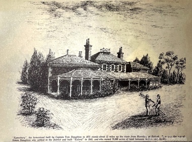
Drawing, Eynesbury, Unknown
"Eynesbury, Eynesbury Road was one of four properties into which Simon Staughton’s Exford station, established in 1841, was subdivided for his sons after his death in 1863. The Eynesbury station of approximately 20,000 acres was inherited by his second son, Samuel Thomas Staughton. Eynesbury remained unsubdivided until redevelopment for residential purposes commenced in the early 2000s, at which time it was the largest pastoral property within 300 kilometres of Melbourne". Detailed sketch of the Eynesbury propertylocal architecture, local identities -
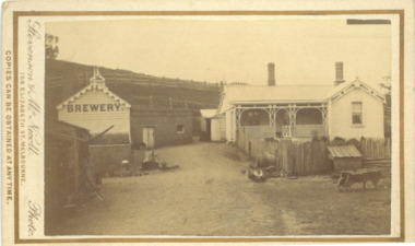 Bacchus Marsh & District Historical Society
Photograph, Symington Brewery, Hopetoun, near Bacchus Marsh 1883
The family of William Symington arrived in Melbourne in 1855. By 1858 they had come to Bacchus Marsh and built a house at Hopetoun a few kilometres east of the town. A brewery next to the house was also built around this time. It was a licensed brewery between 1862 and 1886. The elder William Symington died in March 1867 and the brewery was then operated by his son the younger William Symington for a number of years. It ceased operations sometime before 1900. Small sepia unframed photograph on card with gold border framing photograph. Housed in the album, 'Photographs of Bacchus Marsh and District in 1883 by Stevenson and McNicoll'. The image shows the brewery and house which belonged to the Symington family of Hopetoun, near Bacchus Marsh. The house is a timber structure with two chimneys and a front verandah. The front yard of the house is enclosed by a timber fence. At the front of the fence can be seen a dog kennel. Other tools, such as a wheelbarrow, lie in the yard. The brewery building is of timber and brick. On the hillside behind the buildings are paddocks fenced with post-and -rail fencing.On the front: Stevenson & McNicoll. Photo. 108 Elizabeth St. Melbourne. COPIES CAN BE OBTAINED AT ANY TIME. On the back: LIGHT & TRUTH inscribed on a banner surmounted by a representation of the rising sun. Copies of this Portrait can be had at any time by sending the Name and Post Office Money Order or Stamps for the amount of order to STEVENSON & McNICOLL LATE BENSON & STEVENSON, Photographers. 108 Elizabeth Street, MELBOURNE. stevenson and mcnicoll 1883 photographs of bacchus marsh and district, breweries, symington family bacchus marsh, william symington 1840-1929, william symington 1802-1867 -
 City of Greater Bendigo - Civic Collection
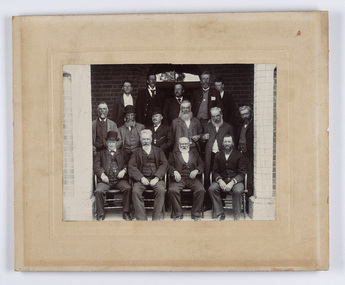
Photograph - Strathfieldsaye Councillor Group Portrait, D.G. Coope & Son - Framers
The district of Strathfieldsaye was proclaimed in 1861 and named a Shire on the 17th September in 1866. It remained a shire until amalgamation in 1994 when it became part of the City of Greater Bendigo. The shire was located 8 km to the south- east of Bendigo and covered an area of 601 square kilometres and extended from the Calder Highway to the Coliban and Campaspe Rivers. The shire's administration centre was in Strathfieldsaye until 1972 when new offices were opened in Kennington.Silver gelatin framed photographic group portrait of fifteen men taken in the alcove of the Strathfieldsaye Shire Hall. Four men are seated and eleven are standing. Photograph is attached directly to cream mount card. Handwritten note with photograph: 1/ John Burke, 2/ (?), 3/ (?), 4/ RHS Abbott, 5/ M Brennan, 6/(?) 7/(?) 1/. M Condon? 2/ (?) 3/ M Burns, 4/(?) Gentlemen at back are probably council staff.shire of strathfieldsaye, strathfieldsaye shire council, president of strathfieldsaye shire, councillor john burke, councillor r.h.s. abbott, councillor brennan, councillor condon, councillor m burns -
 Warrnambool and District Historical Society Inc.
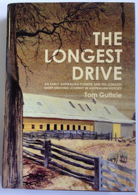
Book, Tom Guthrie, The Longest Drive, 2 McIntyre Street
Biography of Thomas Guthrie (1833-1928)This is a hardcover book of 635 pages. The dust cover is multi-coloured with an image of a painting of the woolshed at Rich Avon on the front. The book has a dark red cover.non-fictionBiography of Thomas Guthrie (1833-1928)western victoria early farming sheep farming and droving guthrie affleck, early farming sheep farming and droving guthrie affleck, droving guthrie affleck, guthrie affleck -
 Warrnambool and District Historical Society Inc.
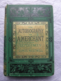
Book, The Autography of a Merchant, late 19th century
This book was given in 1886 as a prize to Annie Egerton from Allansford State School. The prize was for recitation. Allansford State School No. 3 was opened in 1856 as a National School and is still operating. Allansford is about ten kilometres from the Warrnambool city area and most of it today is within the boundaries of the City of Warrnambool. John Jones was the Head Master of the school from 1867 to 1891. No details have been found on Annie Egerton or her family This book is of interest because it concerns 19th century Allansford State School, Head Master John Jones and pupil Annie Egerton. It is also a book of antiquarian interest. This is a hard cover book of 436 pages. It has a green cover with gold and black ornamentation and black and green lettering. The pages are edged with gold colouring. The book has 36 chapters telling the story of the merchant, James Meetwell and some pages at the back giving details of other books available from the publishers, Ward, Lock & Co. The cover is somewhat soiled. There is an inscription inside the front cover with handwriting in black ink and the word ‘Reciting’ written in pencil on the second page. ‘Allansford S. School, 3, Presented to A. Egerton for Reciting, 19-4-86, J.E.Jones, teacher’ ‘Reciting’ annie egerton, allansford primary school, john jones,, allansford state school, history of allansford -
 Ringwood and District Historical Society
Newspaper, Scrapbook Clipping, Library Collection, Ringwood, Victoria
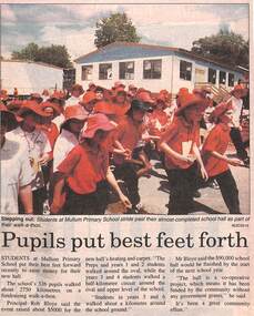
Newspaper Clipping from the ""Mail", 2-12-1997 P16. "Pupils put best feet forth"Pupils at Mullum Primary School took part in a Walkathon to raise money for their new hall. The school's 326 pupils walked about 2750 kilometres on a fund raising walkathon . Principal Rob Bloye said the event raised about $5000 for the new hall's heating and carpet. Mr Bloye said the $90,000 school hall would be finished by the start of the next school year. "The hall is a co-operative project, which means it has been fundfed by the community without any government grants", he said. -
 Orbost & District Historical Society
black and white photograph, 11 February 1971
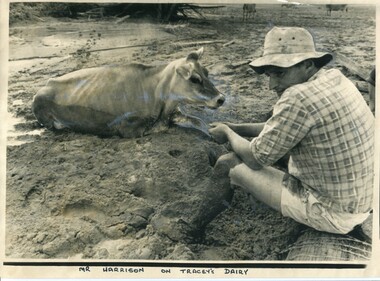
This photograph was taken during the 1971 floods at Orbost. The 1971 flood was the the worst flood on record. At Jarrahmond it was at least 11 metres and up to one and a half kilometres wide on the flats causing enormous damage to the flood plain. Records say that "The brown floodwater stain in Bass Strait could be seen from passing airliners." Considerable damage was done to railway infrastructure, roads and farms. More information from the APRIL, 2008 newsletter by John Phillips. (see orbosthistory.com.au)This is a contemporary pictorial record of a significant local event.A large black / white photograph of a man, dressed in shorts and a checked shirt, sitting on a fence post surrounded by mud. He is holding on to the leg of a cow which is stuck in the mud.on front - "Mr Harrison on Tracey's Dairy" on back - " Herald 11 Feb 1971"floods-orbost-1971 tracey-dairy natural-disaster-flood -
 Warrnambool and District Historical Society Inc.
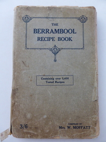
Book, The Berrambool recipe book, 1915
This recipe book has been compiled by Mrs W. Moffatt to raise funds for the Wickliffe Hall Improvement Fund (1915). Wickliffe is a small town in Western Victoria situated on the banks of the Hopkins River on the Glenelg Highway 100 kilometres from Warrnambool. Jessie Moffatt (nee McLellan) married William Moffatt in 1885 and died in 1938. William Moffatt leased the Berrambool Estate near Wickliffe in 1893, bought it in 1903 and the Moffatts lived there until their deaths in the 1930s. This recipe book is of interest because of its social history, telling us what recipes were popular in the early 1900s and the use made of a recipe book to raise funds for local community funds. The book is also of interest because it is an example of the voluntary work done by a woman in the Western District in the early 20th century. The book is also of interest because the names of some of those who contributed the recipes are listed and many of them have local connections. The Warrnambool names listed include Williams and McCormick. This is a soft cover book of 149 pages. The cover is grey with dark blue lettering and some ornamental patterning. The book contains over 1400 recipes and many advertisements for businesses in Victoria at the back and front of the book. There are two loose sheets of paper with recipes. The binding has come apart and has been loosely mended with adhesive tape. The cover and some of the pages are a little tattered. jessie and william moffatt of berrambool, history of warrnambool -
 Warrnambool and District Historical Society Inc.
Notebook, Telephone Code Dialling & Change Book, Mid 20th century
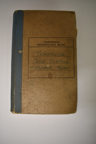
This notebook has been used in the Nullawarre Post Office in the mid 1900s. It lists the telephone exchange codes of places in Victoria and also the code for the telephone charges to those places. Charles and Vida Williams were the Post Master and Post Mistress at Nullawarre Post Office during the mid 20th century years. Nullawarre is a small settlement 25 kilometres south east of Warrnambool and is mainly an agricultural area. European settlement first occurred in the late 1860s. This notebook is of some interest as one used in the day-to-day business of the Nullawarre Post Office in the mid 20th century.This is a notebook which was originally set up as a Postman’s Redirection Book but has been used to list alphabetically telephone exchange areas and their codes. The book has an alphabetical index on the side of the pages and printed black lines and hand-ruled lines on the pages. The cover is light brown with blue binding on the spine and the binding is partly giving way. There is black printing and handwritten writing on the front cover. The material on the pages is handwritten in blue ink and pencil. There is a blue stamp and some pieces of paper pasted into some pages. ‘Postman’s Redirection Book’ ‘Telephone Code Dialling & Charge Book’ ‘Nullawarre’ -
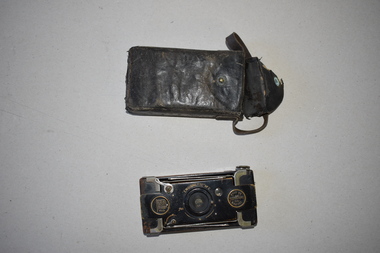 Warrnambool and District Historical Society Inc.
Camera, Eastman Kodak Co, Vest Pocket, 1920s
This camera, made by the American firm of Eastman Kodak, was the best-selling folding camera during the first half of the 20th century. This is the ‘autographic’ model as there is provision at the back of the camera for note-taking. This model was made between 1915 and 1926 and it is called the soldier’s camera because of its compact size. Over 1,000,000 cameras of this type were sold during World War One. This camera belonged to C.C. McNeil of Caramut, a town 55 kilometres north of Warrnambool. This camera is of interest as it belonged to a person from the Warrnambool district and it is a good example of a pocket camera with note-writing facilities. This is a black metal camera in a rectangular shape with rounded edges. It has three glass apertures and a metal winder. It also has an opening shutter at the back of the camera where notes can be written on to the paper backing of the film. The front of the camera opens and a concertina-like metal attachment affixed to the back of the camera can be pulled out to reveal the lens. This is covered in black leather. Printed information etched into the surface can be found in various locations around this camera. Vest Pocket Autographic Kodak U.S. Patents – Mar 4 1902, May 6 1913 Eastman Kodak Co. Rochester N.Y. U.S.A. Celia C. McNeil Caramut 20th century photography, history of warrnambool -
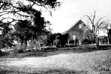
![Photograph - Digital image, Willis Vale [house from distance], 1932c](/media/collectors/4f729f5697f83e03086015b8/items/54fd54082162f10d30c05b8a/item-media/54fd54392162f10d30c05f8f/item-fit-380x285.jpg) Greensborough Historical Society
Greensborough Historical SocietyPhotograph - Digital image, Willis Vale [house from distance], 1932c
Willis Vale: House built by Edward Maygar, Robert Whatmough lived there mid 19th century and later sold to Partington family. It was located on the Plenty River at Partington's Flat Greensborough. Land use included farming and orchards. The derelict Willis Vale house was destroyed in 1964 when a fire originating from North Plenty Gorge - Kurrak Road - was lit by two teenage boys and made its way several kilometres down to Partington's Flat Greensborough.Home of the Partington familyDigital copy of black and white photograph.willis vale, partington family, whatmough, maygar -
 Greensborough Historical Society
Photograph - Digital Image, Willis Vale, 1920c
Willis Vale: House built by Edward Maygar, Robert Whatmough lived there mid 19th century and later sold to Partington family. It was located on the Plenty River at Partington's Flat Greensborough. Land use included farming and orchards. The derelict Willis Vale house was destroyed in 1964 when a fire originating from North Plenty Gorge - Kurrak Road - was lit by two teenage boys and made its way several kilometres down to Partington's Flat Greensborough.Home of the Partington familyDigital copy of black and white photograph.willis vale, partington family, maygar, whatmough -
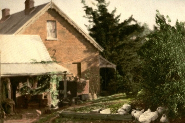 Greensborough Historical Society
Photograph - Digital image, Willis Vale in Colour, 1940c
Willis Vale: House built by Edward Maygar, Robert Whatmough lived there mid 19th century and later sold to Partington family. It was located on the Plenty River at Partington's Flat Greensborough. Land use included farming and orchards. The derelict Willis Vale house was destroyed in 1964 when a fire originating from North Plenty Gorge - Kurrak Road - was lit by two teenage boys and made its way several kilometres down to Partington's Flat Greensborough.Home of the Partington familyDigital copy of colour photograph.willis vale, partington, whatmough, maygar -
![Photograph - Digital image, Willis Vale [front door], 1900c](/media/collectors/4f729f5697f83e03086015b8/items/55029fb42162f11024c2fdd5/item-media/55029fe62162f11024c300cd/item-fit-380x285.jpg) Greensborough Historical Society
Greensborough Historical SocietyPhotograph - Digital image, Willis Vale [front door], 1900c
Willis Vale: House built by Edward Maygar, Robert Whatmough lived there mid 19th century and later sold to Partington family. It was located on the Plenty River at Partington's Flat Greensborough. Land use included farming and orchards. The derelict Willis Vale house was destroyed in 1964 when a fire originating from North Plenty Gorge - Kurrak Road - was lit by two teenage boys and made its way several kilometres down to Partington's Flat Greensborough.Home of the Partington familyDigital copy of black and white photograph.willis vale, partington -
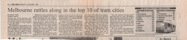 Melbourne Tram Museum
Newspaper, The Age, "Melbourne rattles along in the top 10 of tram cities", 16/1/1995
Newspaper cutting about the position of Melbourne trams in the world in terms of kilometres of track and the number of routes based on Jane's Urban Transport Systems. Has comments from the National Trust, PTUA, and about the tram fleet. Notes the recent growth in the Melbourne system. Item written by Bruce Tobin. How Jane's obtained or intepreted their information is unkinown - a check at the time of cataloguing notes that Prague was 144km and Poznan was about 66km of route - based on their Wikipedia pages. Yields information about Melbourne's position in the world tram list in 1995 - but this is subject to interepretion.Newspaper cutting from The Age 16/1/1995tramways, melbourne, length, routes -
 Warrnambool and District Historical Society Inc.
Book, 055 Telephone Directory 1969, 1969
This telephone directory of 1969 has entries from the Camperdown, Casterton, Colac, Edenhope, Hamilton, Portland and Warrnambool districts. The directory came from the Nullawarre Post Office at the time when Charles Williams was the Post Master (mid 20th century) and delivered two runs of mail a day. His wife, Vida was the Post Mistress. Nullawarre is a small agricultural settlement 25 kilometres south east of Warrnambool and today has a general store, Post Office and school. This telephone directory, which has local provenance (Nullawarre Post Office), will be of great use to researchers as it contains the names and addresses of private individuals and businesses in the Western District of Victoria in 1969. It is also of interest as many of the entries give the names of the country properties at that time and the entries are listed separately under the names of the various towns. This is a soft-cover booklet of 392 pages. The front cover is multi-coloured and has a photograph of a parrot and the back cover has an advertisement in blue and white. There are 200 white pages and 192 pink pages of telephone numbers in Western Victoria in 1969. The printing throughout is black and the pages are very faded. communications, warrnambool, history of warrnambool, 055 telephone directory -
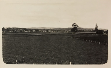 Kew Historical Society Inc
Photograph - Farmland, near Bruthen or Swan Reach, 1926
Henry Beater Christian (1886-1962) , was a descendant of one of the earliest settler families in Kew. Employed at the Kew Asylum as a 'public servant', he was a skilled amateur photographer, photographing numerous scenes in Kew and on his travels around Victoria. The majority of his photographs date from 1916 to 1929. His finest photographs are housed in two photograph albums. Digital copy of a photograph from page 31 of the 47-page photograph album containing 261 gelatinous silver images, loaned by Diane Washfold with permission given to digitise and hold a copy in our collection. John Chapman has written in 'Bushwalking Clubs - A Brief History', about the establishment in Victoria of the first bushwalking club in 1888, and the popularisation of bushwalking during the interwar period. Henry Christian's 'walks' appear to have been undertaken solely or with a companion/s. This black and white photo is part of a group of six photos taken on an 18 kilometre walking trip between Bruthen and Swan Reach in East Gippsland in 1926. The route of the walk followed the Tambo River. The photographer focusses the camera view on the township in the distance with farms in the foreground."BRUTHEN TO SWAN REACH 1926"henry beater christian (1886-1962), landscape photography, christian-washfold collection, photograph albums, bushwalking, bruthen, swan reach, tambo river, east gippsland