Showing 1247 items
matching bay road
-
 Warrnambool and District Historical Society Inc.
Document, Map: Lady Bay 1853, 1853
This is one of the earliest surveys and maps of Warrnambool harbor, Lady Bay. Being done in 1853, it shows the depths of the bay area marked in fathoms, currents and directions and areas of rocks around mouth of the Merri and the Western side of the bay as well as a large sand spit to the middle right of the beach region.. It also marks the large areas of seaweed and fuci in the outer bay area. It has the area of Pertobe Lagoon marked and shows the early tracks to the town. The engraving work was done by Tulloch and Brown, with Tulloch being one of the earliest engravers and lithographers in the state of Victoria. He arrived in Melbourne in 1849 and set up business with James Davie Brown in 1853 with Brown being a map engraver. They were awarded bronze and silver medals for their work at the Victorian Industrial Exhibition. He also worked in the vignettes on the Proeschel Map of Victoria.This map is of high historical and comparitive significance as it shows the Lady Bay area prior to the changes that have occurred in the last 160 years with the building of the breakwater. The issue regarding access to Lady Bay remains a current one. The engraver D Tulloch engraved some of the earliest scenes of the goldfields in Ballarat and as such has left a record of a very early and important era in Australian history. Rectangular cream paper with black text. Map area is outlined by fine black lined border. Key in top right hand corner and scale at bottom middle of map.Map is labelled Town of Warrnambool printed at top of map. Small logo at top right corner which has “Hydrographic Department” in circle around an anchor. Lady Bay Warrnambool Surveyed by John Barrow assistant surveyor Engraved by Tulloch & Brown in bottom right corner. Melbourne engraved by order of the legislative Council of Victoria in middle bottom.map, warrnambool, town of warrnambool map 1853, tulloch & brown map 1853, lady bay warrnambool,, warrnambool harbour, warrnambool breakwater, warrnambool beach -
 Warrnambool and District Historical Society Inc.
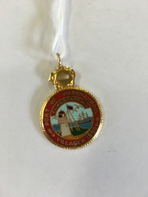
Badge, Port of Warrnambool Flagstaff Hill, Late 20th century
Flagstaff Hill is a maritime museum which draws on the rich maritime history of the region. It is situated overlooking Lady Bay in Warrnambool and is designed to represent the town of Warrnambool in around the 1870-80’s As well as paid staff on site it enjoys a large volunteer group who do various tasks around the village from tours to maintenance and recording of information. This badge recognises the contribution of one such volunteer. An item which recognizes effort in the local community.Round gold edged medal with picture of lighthouse and flagstaff surrounded by red with gold lettering. Number engraved on back.698 engraved on back. Port of Warrnambool Villager 1850. Flagstaff Hillflagstaff hill badge, warrnambool -
 Warrnambool and District Historical Society Inc.
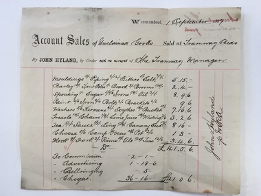
Docket, Hyland/ Tramways Sheds, Circa 1887
In 1858 a tramway was constructed to move goods between Warrnambool township and jetty on Lady Bay. It was established on the south side of Merri St in the approximate site of the present railway station. Large stores were also built near where the present rail lines to hold produce. This docket relates to unclaimed goods and range from tent poles, brooms, sugar scythes, lime juice tea, sauce, camp ovens and ale. John Hyland was the manager who was later mayor of Warrnambool. The Warrnambool tramway was an important part of transportation of goods in the 19th century from the port to the township which was over a mile away. White docket with some text printed in black with other sections handwritten in black pen. Dated September 1887. It shows a list of varied items. Signed John Hyland. “Account sales unclaimed goods by J Hyland Sep 1887” is in red pen on the back. warrnambool, warrnambool tramways, john hyland, unclaimed goods, -
 Warrnambool and District Historical Society Inc.
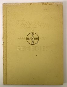
Book, Fifty Years of Remedies Bayer 1888-1938, 1938
Remedies available from Bayer PharmaceuticalsThis is a book of 90 pages, The cover is beige with embossed white and gold printing. The spine is somewhat worn. The pages contain printed text and black and white photographs and illustrationsnon-fictionRemedies available from Bayer Pharmaceuticalsbayer company of germany, pharmaceuticals -
 Warrnambool and District Historical Society Inc.
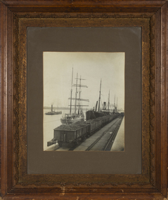
Photograph - Framed photograph of ship 'Speculant', c. 1910
This is a photograph of the ship, 'Speculant' at the Warrnambool Breakwater. There is another ship alongside the 'Speculant' and the dredge, 'Pioneer' is in the background. The 'Speculant' was a three masted barquentine of 412 tons built in Scotland in 1895. It was purchased by P. J. McGennan in 1902 and wrecked at Cape Patton, near Apollo Bay, in 1911. It was one of the few ships to be registered at the Warrnambool port. Peter John McGennan (1844-1920) was a cooper by trade, initially operating a shop in Warrnambool making cheese vats, churns, coolers and tanks. He then opened a factory in South Warrnambool making butter boxes, nails and barbed wire. He owned several ships, using them to import material for his businesses, especially white pine timber from New Zealand, and to export his own products. He was a Warrnambool Councillor from 1885 to 1891.This photograph is of interest as a reminder of the importance in the late 19th century and early 20th century Warrnambool of Peter McGennan and his industries and community work.This is a black and white photograph of three ships. It is enclosed in glass with a varnished wooden frame with an ornate edging. The photograph shows one ship in the background and two at the Warrnambool breakwater with some railway cartage trucks in the foreground.ship 'speculant', dredge 'pioneer', p.j. mcgennan -
 Warrnambool and District Historical Society Inc.
Functional object - Ginger Ale Bottle, John Fletcher. Koroit Street, Warrnambool, c. 1930
This bottle was found in sea water while the donor was snorkelling in Stingray Bay, Warrnambool. It is a marble stopper bottle from the Warrnambool cordial factory of John Fletcher. Th bottle was filled upside down so that as soon as the filling ceased the marble was forced down to seal the bottle against a rubber ring (missing in this bottle). Pressure inside the bottle would keep the marble pressed against the top of the neck. To open the bottle the marble was pressed down so that it fell into the body of the bottle. John Fletcher as a young boy worked at Rowley's Cordial Factory in Banyan Street, Warrnambool. He then worked for John Davis who had established the Union Cordial Factory in Koroit Street in the 1860s. In 1885 John Fletcher bought Davis' business and operated it until 1930. It was then bought by Ralph Reeves. John Fletcher manufactured soda water, lemonade, tonic waters, ginger ale, sarsaparilla, cordials, hop beer and hop bitters.This bottle is of some interest as an example of a marble stopper bottle over 90 years old and as a memento of the Warrnambool soft drinks business of John Fletcher, a prominent businessman in Warrnambool for over 40 years.This is a clear glass bottle with a rounded body, a heavy indentation near the base of the neck and a thick tapering neck with a round opening. The bottle contains a green marble and some marine detritus. The bottle is discoloured with stains and dirt and has lettering etched into the side and base.John Fletcher Ginger Ale Warrnambool This bottle is the property of John Fletcher Warrnambool and cannot be legally used by others Gjohn fletcher warrnambool, cordial manufacturers in warrnambool -
 Warrnambool and District Historical Society Inc.
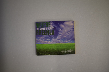
DVD, Where the Grass is Always Greener - Warrnambool, 21st century
This is a promotional DVD issued by the Warrnambool City Council. The emphasis is on the coastal areas around Warrnambool and active recreational pursuits for the visitor – whale watching at Logans Beach, swimming at the Lady Bay beach, cycling on the coastal promenade etc. This is of minor interest as an example of the promotional material issued by the Warrnambool City Council in the second decade of the 21st century..1 A lightweight cardboard older with six sides, one containing a DVD and five containing images of Warrnambool. .2 A DVD with black and white printing on one side. warrnambool city council, tourism in warrnambool, history of warrnambool -
 Warrnambool and District Historical Society Inc.
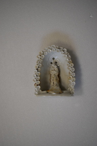
Decorative object - Madonna and Child
This item was found in 2018 washed up on the beach at Lady Bay in Warrnambool. It is a religious object and is similar to ones made and sold to be used in the home on a family altar or as an ornament on a shelf. It may originate from Italy. The display of items such as this would have been common in the early to mid 20th century, particularly in the homes of those belonging to the Catholic religion. The owner of this item is not known but it is retained for display purposes.This is a white china object with a statue of a Madonna and Child recessed into a oval-shaped setting. There are three holes at the top of the statue for attaching the item to a wall or shelf. The edge of the item is decorated with a pattern of white shells. At the foot of the statue is the remnant of a decorative piece broken off. warrnambool, religious ornaments -
 Warrnambool and District Historical Society Inc.
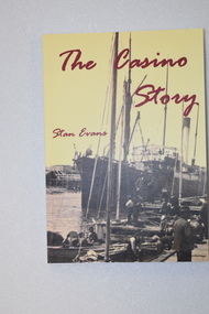
Book - book & bookmark, The Casino Story, 1882
History of the ship, 'Casino'.1 This is a book of 145 pages.The cover has a yellow background with an image of a ship and dark red printing. The back cover and spine have red and black printing. The pages contain black and white photographs and sketches and printed material. .2 This is a bookmark with two colour images and printed material on one side and one image and printed material on the other side.non-fictionHistory of the ship, 'Casino'the ship 'casino', warrnambool shipping history -
 Warrnambool and District Historical Society Inc.
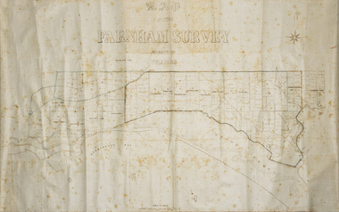
Map - Farnham Survey, 1850s
This is a map of the Farnham Special Survey. In 1843 William Rutledge purchased this Special Survey of 5,120 acres and named it Farnham. This Survey extended from Tower Hill to the Merri River at Dennington. The map appears to date from the 1850s This early map is of considerable significance as it shows details of the Farnham Special Survey. William Rutledge and his survey are important influences in the development of Warrnambool and district with the establishment of settlements at Killarney, Yangery and Tower Hill.A hand drawn map on waxed paper in brown, black and blue ink. It shows Armstrong's Bay, sea, Crown Land , the names of properties and some roads. It includes a compass direction diagram.farnham special survey -
 Eltham District Historical Society Inc
Document - Property Binder, 967 Main Road, Eltham
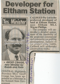
Newspaper article: Developer for Eltham Station, The Advertiser, April 16, 1996 The original Station Master's house situated in present-day bus bay was sold in 1986 for $1 to save it from demolition and was then relocated to 58 Park Road.58 park road, 967 main road, businesses, eltham, eltham railway station, houses, main road, property, station masters house, station master's house eltham -
Glen Eira Historical Society
Article - Rosemont, Kooyong Road, 112A, Caulfield North
Eight items about this property: Handwritten notes from 1870 Caulfield rate book along with list of owners 1870-1890; unsigned and undated. Short history of Rosemont from 1860’s with owners listed up to 1895. Includes description of land and architectural features of house with sketch of pillar. Unsigned and undated with both typed and handwritten information. Unsigned and undated note (original and photocopy) about 112 Kooyong Road and Rosemont’s changing address over time. Photocopy of Andrew Ward’s Heritage Study (two pages) on 112 Kooyong Road (rear) describing significance, history and description of property. Includes photo. Online print without photo of same Heritage Study with handwritten note about brick exterior provided by owner/occupier to compiler Andrew Frederick 2010. Excerpt from Caulfield’s Building Heritage p.47-48 Volume 1 by Dr. Geulah Solomon about Rosemont giving description and history (start of entry on page 46 omitted). Added by Claire Barton date unknown. Notes taken by Andrew Frederick from Caulfield Heritage Vol.1 pages 47-9 re history; and from Sands and McDougall Directories of 1874, 1903, 1911, 1913 and 1923; plus 1913 entry in Vict. P.O Directory. These show house numbers and owners for those periods. Three pages of plans relating to Rosemont covering ground and first floors.rosemont, caulfield north, howitt godfrey dr., kooyong road, blake arthur, grice james, cast iron work, cellars, campbell john a., campbell john archibald, stables, verandahs, king thomas, howitt’s corner, howitt alfred william, farm houses, bakewell john, architectural features, bricks, mcwilliams robert, rosemont estate, mansions, howitt william godfrey dr., arches, balaclava road, coach houses, outbuildings, timber houses, squatters, campbell john, connelly mrs., king florence, slate tiles, ward andrew, chimneys, fireplaces, allen george, warburton james, mirfield professor, hall william sir, hall lady, land subdivision, cellars, embossed leather features, bay windows, house names, victorian style, ceilings, stairs, gardens -
Glen Eira Historical Society
Letter - LePage Family
This file has 7 items. 1.Certified copy dated 28/05/1975 of birth certificate of Phoebe Elizabeth Marsh on 08/05/1869 in Chewton Victoria, and certified copy dated 22/05/1975 of marriage certificate of Ignatius John LePage and Phoebe Marsh on 14/06/1906 in Bendigo. 2.Photocopy of will of Ignatius John LePage dated 07/09/1933 and of inventory and probate application dated 1940. 3.Photocopy of will of Phoebe LePage dated 06/11/1971. 4.Photocopy of praecipe to probate registrar concerning will of Phoebe LePage dated 28/11/1941. 5.Photocopy of inventory of possessions in the estate of Phoebe Marsh dated 17/03/1942. 6.Correspondence dated 30/01/1994 and 10/05/1994 to Felicity Campbell, of Caulfield Historical Society from William Norris concerning his LePage family history notes. 7.Handwritten notes titled ‘The Marsh Bayle LePage Caulfield Connection’ by William Morris dated 10/01/1994 concerning the LePage family history in the Caulfield area.marsh phoebe elizabeth jane, lepage phoebe elizabeth jane, lepage ignatius john, elsternwick, carre street, orrong road, st joseph’s elsternwick, state savings bank elsternwick, norris william, bentleigh, vickery street, caulfield historical society, keating betty, holland grove, north caulfield, ford hazel, campbell felicity, vallati gladys, imperial avenue, hawthorn road, glenhuntly road, alder street, liquor shops, halesowen, grocers, marsh victor james bernard, berklea private hospital, kooyong road, briggs street, marsh alice, newstead street, marsh lucie, marsh charlie e.c., marsh dudley ward, murrumbeena state school, oak street, phoebe theatre, bayly james b., chloris crescent, bambra road, lepage catherine, turnbull charles, murrumbeena road, murrumbeena, dandenong road, renown theatre, quantrelle madge, gunning margaret, grange road, glenhuntly, mcnamara madge, st george road, lepage winnie, marsh edwin charles, lepage ellen, orrong grove, sandham street, st joseph’s convent -
Glen Eira Historical Society
Article - Portavoe, Alma Road, 359, Caulfield North
Photocopied photo of Portavoe and extract from Andrew Ward’s 1994 conservation study of home. Describes architect- vrol features, history and significance of the house. Gives brief history of owner/occupant from 1903 to 1908.alma road, kooyong road, verandahs, chimneys, portavoe, bon accord, stained glass, edgar john m., edwardian style, ward andrew, muntz street, federation style, caulfield north, mansions, slate tiles, balconies, bay windows -
Glen Eira Historical Society
Article - Shoobra Road, 53, Elsternwick, 'Linbrae'
Three articles on 53 Shoobra Road: Melbourne Weekly Bayside magazine auction features dated 06/10/2010 and 20/10/2010 giving brief details of interior features and external extras. Articles include four and seven photographs respectively of house interior and exterior. Handwritten research by Claire Barton taken from Sands and MacDougalls editions 1910, 1913, 1923, 1942, 1948 and 1960 dated 30/09/2011.shoobra road, elsternwick, 'linbrae', biggin scott, williams kharla, stavrakis bill, architectural features, architectural styles, cast iron work, real estate agents, bryant samuel rev., bay windows, hestia, house names, appleton bv miss, victorian style, marble, fireplaces -
Glen Eira Historical Society
Letter - RIDDELL PARADE, 78, ELSTERNWICK
Two items about this property: 1/Contains a report for A J Barley Pty Ltd (Real Estate Agent) by Hilary Bullock and Rosalind Landells of Brighton Historical Society on the property at 78 Riddell Parade Coolara from November 15 1985. Includes a brief history of the area, a list of owners/residents and some information on architectural details of the house. Also contains a letter of apology and explanation dated 30 November 1985 from Mrs Landells over an error of interpretation which led to a mistake in the report. 2/Auction flyer, date unknown (but likely circa November 1985), for Bay View Villa for rela estate agent A J Barley.walker mary, riddell john carre, cavers carre, ross william murray, elsternwick, carnegie, rosstown, railway lines, rosstown junction railway, jefferson m g b, ward cole george, cole george ward, williams fred, hughes horace c, railway crescent, riddell parade, orrong road, cottages, land subdivision, coolarra, bayview villa, bay view villa, plaster moujlds, fireplaces, a. j. barley pty ltd, estate agents, o'brien dorothy, victorian style, 'cavers carre', house names -
Glen Eira Historical Society
Document - Roseneath, Nepean Highway, 31, Elsternwick
A photocopy of a Caulfield Conservation Study conducted in January 1995 by historian Andrew Ward of the house Roseneath named thus by 1904. The document includes a photocopied photograph of the front façade, although the features are unclear. The document, which includes a bibliography, details the history of Roseneath, including owners and occupiers, as well as the architectural features of significance and historical value.ward andrew, millar william, boyle andrew, worthington george, tulloch annie, cross anastasia, meek alex, caulfield, roseneath, elsternwick, nepean highway, mcmillan street, point nepean road, rusden street, cumbernauld, hawthorn road, glenmoore, st. georges road, caulfield south, shire of caulfield, east st. kilda riding, historic buildings register, national trust register, national estate register, italianate style, architectural styles, architectural features, mansions, brick houses, verandahs, cast iron work, bluestone, bay windows, land subdivisions, merchants, judges, leases, councillors -
Glen Eira Historical Society
Document - Shoobra Road, 20, Elsternwick
This file contains three articles about this property: Shoobra Road, 20, Elsternwick. 1/Advertising article from unknown source, dated April 2002, by Buxton. Gives brief interior feature details. Includes 3 coloured photographs. 2/Handwritten research on former occupiers of 20 Shoobra Road, taken from Sands and MacDougalls, by Claire Barton 19/06/2012. 3/Advertising feature article in Domain 11-12/11/2016. Article gives details of home renovations update since being bought in 2002. Article details across 3 columns the community values of Elsternwick area and surrounds, and includes a further three properties in the area, also up for auction. It includes a long column titled 'My Patch' from the current owner Amanda Ruben.elsternwick, stavrakis bill, architectural features, shoobra road, buxton, architectural features, real estate agents, bay windows, phelan john., lead lights, phelan f., glenhuntly road glen eira road, marleston park, ruben amanda, gardy mark, gardy cooper, gardy milla, edwardian style, 'miss ruben', restaurants, ripponlea, st. george's road, bertram street, orrong road -
Glen Eira Historical Society
Article - Shoobra Road, 63, Elsternwick
3 items on 63 Shoobra Road: 1/An advertising article dated 19/03/2004, from Property Review Weekly, giving details of original features and renovations done to 63 Shoobra Road, for forthcoming auction by Gary Peer. 2/Handwritten research by Claire Barton on 63 Shoobra Road giving house name in the 1910 Sands & McDougalls and owner/tenant, dated 30/09/2011. 3/An auction advertisement for 63 Shoobra Road on 06/12/2014 (newspaper add hand-dated as 11/11/2014).shoobra road, real estate agents, house names, elsternwick, wymswold, verandahs, street charles, fireplaces, architectural features, cast iron work, marble, gary peer & associates, stables, bay windows, carports -
Glen Eira Historical Society
Article - Long Street, 7, Elsternwick
... Advertisements Victorian Style Land sales Houses Glenhuntly Road ...A real estate advertisement dated 28/09/2005, source unknown regarding the sale of 7 Long Street, Elsternwick. The advertisement by real estate agent Mark Rogers includes a description of the house and a copy of a colour photograph of the exterior of the house.elsternwick, long street, advertisements, victorian style, land sales, houses, glenhuntly road, colbinabbin, bay windows, rogers mark, real estate agents -
Glen Eira Historical Society
Document - Nettalie
Two photocopies of the October 1994 Caulfield Conservation Study by Andrew Ward of the house at 73 Balaclava Rd Caulfield named Nettalie by 1899. In the documents(s) Ward details the history of ownership and land values the architectural features and historical significance. A bibliography is included as well as a photograph of the front facade of Nettalie which like the study includes two copies but of varying sizes.ward andrew, forsyth william, forsyte william, noall william, grimwade frederick shepherd, desailly alfred, bryant bessie, bryant herbert, ware martha, cameron william, nettalie, balaclava road, orrong road, caulfield north, fosbery ave, netley, harleston, caulfield north, historic building register, national estate register, national trust register, melbourne grammar school, cast iron work, verandahs, victorian style, stained glass, architectural features, architectural styles, brick houses, stables, mansions, pharmacists, lawyers, doctors, flats, schools, bay windows, land values -
Glen Eira Historical Society
Document - Cantala
Various documents and correspondence detailing the history of the house and land on the corner of Dandenong and Waiora Roads, Caulfield, known as Cantala before being demolished and the land subdivided. The first document is a typed 3 page history from Caulfield Historical Society dated 02/1974, describing the owner of the property, Septimus Miller, as well as architectural features of the house Cantala. The second document is one page of typed correspondence from T J Hart to the editor of Southern Cross, dated 01/11/1973, describing the architectural features and history of Cantala. The file also includes a copy of a typed letter from Brighton Historical Society concerning research conducted about Cantala and the subdivision and detailing the owners and occupiers of flats erected where Cantala stood. Accompanying this document is a one page handwritten note providing the same details. Finally, the file includes a one page photocopy, undated, of an entry in Who’s Who in the World of Women of Mrs Septimus Miller (Muriel), the second wife and widow of Septimus Miller.miller septimus, miller henry money, mattinson elizabeth, bell clara johnstone, stewart gwendoline, henderson helen muriel, miller ronald nevil damian, salway william, hart t j, miller helen, pirera m t, fetter a, bullock hilary, landells rosalind, redleap, cantala, caulfield, caulfiled north, dandenong road, wiora, waiora road, alma road, brighton cemetery, caulfield racecourse, findon avenue, cantala avenue, olgita, rivoli, caulfield historical society, victoria racing club, horse racing, italianate style, art deco, architectural styles, architectural features, balconies, towers, stairs, bay windows, mansions, stables, land subdivisions, monuments and memorials, gothic (revival) architecture, drawing rooms, walking trails, parks and reserves, gardens, flats -
 Glen Eira Historical Society
Article - Cantala
Two photocopied articles, including 3 original prints of photographs, all unattributed, about the house and property known as Cantala, owned by Septimus Miller. 1/The first article is from the Australasian newspaper, dated 18/03/1893, including two original prints (from 6 photographs in the article). The article is accompanied by one page of handwritten notes, undated and unattributed, detailing and summarising the Australasian article. 2/The second article (2 copies) is from Punch, dated 29/10/1903 and includes one original print (from 7 photographs in the article).miller septimus, salway mr, miller mrs, lauderdale mr, redleap (horse), echo (sculpture), sleeping ariadne (sculpture), cantala, caulfield, caulfield north, dandenong road, kooyong road, wiora, australasian, punch, victoria racing club, photographs, towers, italianate style, mansions, balconies, stairs, drawing rooms, bay windows, architectural features, architecutral styles, gates, gardens, stables, art, sculpture, statutes, racehorses, horses, horseracing, business people, commerce, miller helen, miller damien, garden parties, social life and customs -
 Eltham District Historical Society Inc
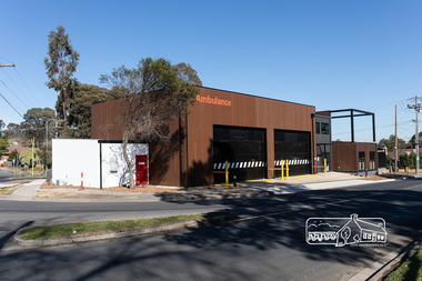
Photograph, Peter Pidgeon, Official opening of the new Eltham Ambulance Branch, Apex Way, Montmorency, 29 August 2018, 29 Aug 2018
Dignitaries included Ambulance Victoria CEO Tony Walker, Vicki Ward MP for Eltham and Jill Hennessey State Ambulance Services Minister The Eltham Apex Club conducted a Community Service Project (1965-1968) to raise funds for a new Ambulance Station to service the community. A site bounded by the intersection of Main Road, Grand Boulevard and Looker Road at Montmorency was purchased in 1969. In 1970, Eltham Shire Council undertook roadworks to construct Apex Way in preparation for the new station as well as duplicate Main Road, Lower Plenty, east of Grand Boulevard including the new Lower Plenty Bridge, which had been opened in November 1966, bordering with the City of Heidelberg. Diamond Valley Leader, September 5, 2018, p4. MONTMORENCY $1.6mil station unveiled A REVAMPED Montmorency ambulance station has been unveiled. State Ambulance Services Minister Jill Hennessy and Eltham State Labor MP Vicki Ward revealed the $1.6 million complex at the corner of Grand Boulevard and Apex Way in Montmorency. It replaces the 50-year-old station and now includes four ambulance bays, four rest and recline rooms, a large training room and offstreet parking for staff. “The community campaigned long and hard for this new ambulance station and I’m delighted to have stood with them all the way,” Ms Ward said. The latest quarterly performance data showed 90.4 per cent of ambulances in Banyule arrived within 15 minutes of Code 1 emergencies — up from 89.2 per cent three months earlier. Ms Hennessy said paramedics had worked in “cramped” facilities. “We’ve fixed that,” she said.55 born digital imagesambulance victoria ceo, apex way, apex-diamond valley ambulance station, eltham ambulance station, eltham apex club, jill hennessey, montmorency, mp for eltham, state ambulance services minister, tony walker, vicki ward -
 Eltham District Historical Society Inc
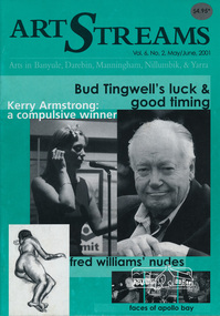
Journal, Peter Doughtery, ArtStreams: Arts in Banyule, Darebin, Manningham, Nillumbik, & Yarra; Vol. 6, No. 2, May-June 2001, 2001
Vol. 6, No. 2, May-Jun 2001 CONTENTS Charles Tingwell A not so little star continues to rise 3 Jon Campbell On the Road to Mid-Career Status 6 Theatre Reviews Peter Dougherty in The Sinbin 9 Cathy Oliver Visits the Mikado 20 Kerry Armstrong "Too Old to Up and Come" 10 Short Story Wheeling Ronnie by R. G. Topham 12 Apollo Bay Great Weather ... Greater Music 14 Fred Williams The Pencil or the Brush 16 Book Reviews Michelle Lonsdale on Paul Kelly 18 Jodie Moran on Wineyards 19 Australian Classical Music Elizabeth Scarlet 21 Anne Delaney on The Lovemakers 22 CD Reviews 24 Artin' About 26 Wining & Dining 30 Artists' Services and Teaching 32 "Peter Dougherty has been involved in the local art scene for many years. As publisher and editor of the arts magazine Artstreams, his comments on the various branches of the arts are widely respected. His "The Arts" column in the Diamond Valley Leader presents a brief summary for a much wider cross section of the local community. Peter also operates his own gallery and the Artstreams Cafe at the St Andrews market. Peter has a wealth of knowledge about present day and historical aspects of local art and artists." - Eltham District Historical Society Newsletter No. 161, March 2005Colour front and back cover with feature articles and literary pieces with photographs and advertisements printed in black and white. 36 pages, 30 cm. Vol. 1, no. 1 (Nov. 1996) - Vol. 10, no. 5 (summer ed. 2005/06) art streams, bridget mcdonnell gallery, bud tingwell, jon campbell, christine croydon, wintyre recital gallery, warrandyte artworks gallery, montsalvat, ray mooney, ray mooney, peter oyston, carlton courthouse theartre, kerry armstrong, r. g. topham, eltham wiregrass gallery, apollo bay music festival, winter in banyule, fred williams, dynamic vegies, bulleen art & garden centre, plenty views golf park, kinglake gallery, nillumbik art award, thompsons pharmacy -
 Eltham District Historical Society Inc
Opening of Meruka Childcare Co-operative, Meruka Park, 5 Meruka Dr, Eltham, April 1994
In 1919 J.B. North, a violinist with the then Melbourne Symphonic Orchestra, and Monsieur Leon Lambert, a French architect, who later designed the Glaciarium Ice Skating Rink, purchased three available farms, Looker's, Wright's and Taylor's, approximately 60 acres, the area running along the creek and being bordered by the present day Ryans Road, Karingal Drive and Sherbourne Road. The farms were used for orchards and market gardens. Leon Lambert designed and built two homes on the farm site, one for the North family, ‘Tralford’, and the other, ‘Glen Ellen’, for himself and his wife. The homes were considered as "brother and sister" and they each included in their design an identical bay window in the main living area. "Glen Ellen" originally comprised kitchen, lounge room, inglenook, dining room, bath room and sleepout. Although the home has been extended over the years, much of the original architecture has been retained including timber panelling and three fireplaces. The land was subdivided in approximately 1966 with "Glen Ellen" retaining approximately one half acre of land fronting Meruka Drive. The property then passed from the Charleston family to Gerald and Margaret Sutton in 1976 and again was sold in 1980 and lastly sold again in 1994. The Norths named their house 'Tralford'. According to Marjorie North, the name Meruka was suggested by Alan Gardner and so was apparently not used by the North family. The name appears to be of Indian origin and its connection with the land is not known. ‘Tralford’ stayed in the North family for many years. Eltham Council acquired the house to create Meruka Park. The house was used for some years by the Council as a community arts facility and as emergency accommodation. It fell into disrepair and was demolished about 1990. The Meruka Child Care Centre has been built on the site and incorporates some of the architectural features of the old house. The Co-op was opened in April 1994. The original drive flanked by large old cypress trees remains. These trees are considered to be of local heritage significance and for this reason Meruka Park is covered by a Heritage Overlay under the Nillumbik Planning Scheme. Part of the park has been preserved as habitat for rare local flora. LL's house, named ‘Glen Ellen’, remains in a well-preserved state and fronts Meruka Drive.cr pam sladden, eltham, meruka child care co-operative, meruka house, meruka park -
 Eltham District Historical Society Inc
Opening of Meruka Childcare Co-operative, Meruka Park, 5 Meruka Dr, Eltham, April 1994
In 1919 J.B. North, a violinist with the then Melbourne Symphonic Orchestra, and Monsieur Leon Lambert, a French architect, who later designed the Glaciarium Ice Skating Rink, purchased three available farms, Looker's, Wright's and Taylor's, approximately 60 acres, the area running along the creek and being bordered by the present day Ryans Road, Karingal Drive and Sherbourne Road. The farms were used for orchards and market gardens. Leon Lambert designed and built two homes on the farm site, one for the North family, ‘Tralford’, and the other, ‘Glen Ellen’, for himself and his wife. The homes were considered as "brother and sister" and they each included in their design an identical bay window in the main living area. "Glen Ellen" originally comprised kitchen, lounge room, inglenook, dining room, bath room and sleepout. Although the home has been extended over the years, much of the original architecture has been retained including timber panelling and three fireplaces. The land was subdivided in approximately 1966 with "Glen Ellen" retaining approximately one half acre of land fronting Meruka Drive. The property then passed from the Charleston family to Gerald and Margaret Sutton in 1976 and again was sold in 1980 and lastly sold again in 1994. The Norths named their house 'Tralford'. According to Marjorie North, the name Meruka was suggested by Alan Gardner and so was apparently not used by the North family. The name appears to be of Indian origin and its connection with the land is not known. ‘Tralford’ stayed in the North family for many years. Eltham Council acquired the house to create Meruka Park. The house was used for some years by the Council as a community arts facility and as emergency accommodation. It fell into disrepair and was demolished about 1990. The Meruka Child Care Centre has been built on the site and incorporates some of the architectural features of the old house. The Co-op was opened in April 1994. The original drive flanked by large old cypress trees remains. These trees are considered to be of local heritage significance and for this reason Meruka Park is covered by a Heritage Overlay under the Nillumbik Planning Scheme. Part of the park has been preserved as habitat for rare local flora. LL's house, named ‘Glen Ellen’, remains in a well-preserved state and fronts Meruka Drive.eltham, meruka child care co-operative, meruka house, meruka park, cr. peter graham, peter staples, richard allen, sheryl garbutt, bill penrose -
 Eltham District Historical Society Inc
Opening of Meruka Childcare Co-operative, Meruka Park, 5 Meruka Dr, Eltham, April 1994
In 1919 J.B. North, a violinist with the then Melbourne Symphonic Orchestra, and Monsieur Leon Lambert, a French architect, who later designed the Glaciarium Ice Skating Rink, purchased three available farms, Looker's, Wright's and Taylor's, approximately 60 acres, the area running along the creek and being bordered by the present day Ryans Road, Karingal Drive and Sherbourne Road. The farms were used for orchards and market gardens. Leon Lambert designed and built two homes on the farm site, one for the North family, ‘Tralford’, and the other, ‘Glen Ellen’, for himself and his wife. The homes were considered as "brother and sister" and they each included in their design an identical bay window in the main living area. "Glen Ellen" originally comprised kitchen, lounge room, inglenook, dining room, bath room and sleepout. Although the home has been extended over the years, much of the original architecture has been retained including timber panelling and three fireplaces. The land was subdivided in approximately 1966 with "Glen Ellen" retaining approximately one half acre of land fronting Meruka Drive. The property then passed from the Charleston family to Gerald and Margaret Sutton in 1976 and again was sold in 1980 and lastly sold again in 1994. The Norths named their house 'Tralford'. According to Marjorie North, the name Meruka was suggested by Alan Gardner and so was apparently not used by the North family. The name appears to be of Indian origin and its connection with the land is not known. ‘Tralford’ stayed in the North family for many years. Eltham Council acquired the house to create Meruka Park. The house was used for some years by the Council as a community arts facility and as emergency accommodation. It fell into disrepair and was demolished about 1990. The Meruka Child Care Centre has been built on the site and incorporates some of the architectural features of the old house. The Co-op was opened in April 1994. The original drive flanked by large old cypress trees remains. These trees are considered to be of local heritage significance and for this reason Meruka Park is covered by a Heritage Overlay under the Nillumbik Planning Scheme. Part of the park has been preserved as habitat for rare local flora. LL's house, named ‘Glen Ellen’, remains in a well-preserved state and fronts Meruka Drive.eltham, meruka child care co-operative, meruka house, meruka park, cr. john cohen -
 Eltham District Historical Society Inc
Opening of Meruka Childcare Co-operative, Meruka Park, 5 Meruka Dr, Eltham, April 1994
In 1919 J.B. North, a violinist with the then Melbourne Symphonic Orchestra, and Monsieur Leon Lambert, a French architect, who later designed the Glaciarium Ice Skating Rink, purchased three available farms, Looker's, Wright's and Taylor's, approximately 60 acres, the area running along the creek and being bordered by the present day Ryans Road, Karingal Drive and Sherbourne Road. The farms were used for orchards and market gardens. Leon Lambert designed and built two homes on the farm site, one for the North family, ‘Tralford’, and the other, ‘Glen Ellen’, for himself and his wife. The homes were considered as "brother and sister" and they each included in their design an identical bay window in the main living area. "Glen Ellen" originally comprised kitchen, lounge room, inglenook, dining room, bath room and sleepout. Although the home has been extended over the years, much of the original architecture has been retained including timber panelling and three fireplaces. The land was subdivided in approximately 1966 with "Glen Ellen" retaining approximately one half acre of land fronting Meruka Drive. The property then passed from the Charleston family to Gerald and Margaret Sutton in 1976 and again was sold in 1980 and lastly sold again in 1994. The Norths named their house 'Tralford'. According to Marjorie North, the name Meruka was suggested by Alan Gardner and so was apparently not used by the North family. The name appears to be of Indian origin and its connection with the land is not known. ‘Tralford’ stayed in the North family for many years. Eltham Council acquired the house to create Meruka Park. The house was used for some years by the Council as a community arts facility and as emergency accommodation. It fell into disrepair and was demolished about 1990. The Meruka Child Care Centre has been built on the site and incorporates some of the architectural features of the old house. The Co-op was opened in April 1994. The original drive flanked by large old cypress trees remains. These trees are considered to be of local heritage significance and for this reason Meruka Park is covered by a Heritage Overlay under the Nillumbik Planning Scheme. Part of the park has been preserved as habitat for rare local flora. LL's house, named ‘Glen Ellen’, remains in a well-preserved state and fronts Meruka Drive.eltham, meruka child care co-operative, meruka house, meruka park, rob hauser -
 Eltham District Historical Society Inc
Opening of Meruka Childcare Co-operative, Meruka Park, 5 Meruka Dr, Eltham, April 1994
In 1919 J.B. North, a violinist with the then Melbourne Symphonic Orchestra, and Monsieur Leon Lambert, a French architect, who later designed the Glaciarium Ice Skating Rink, purchased three available farms, Looker's, Wright's and Taylor's, approximately 60 acres, the area running along the creek and being bordered by the present day Ryans Road, Karingal Drive and Sherbourne Road. The farms were used for orchards and market gardens. Leon Lambert designed and built two homes on the farm site, one for the North family, ‘Tralford’, and the other, ‘Glen Ellen’, for himself and his wife. The homes were considered as "brother and sister" and they each included in their design an identical bay window in the main living area. "Glen Ellen" originally comprised kitchen, lounge room, inglenook, dining room, bath room and sleepout. Although the home has been extended over the years, much of the original architecture has been retained including timber panelling and three fireplaces. The land was subdivided in approximately 1966 with "Glen Ellen" retaining approximately one half acre of land fronting Meruka Drive. The property then passed from the Charleston family to Gerald and Margaret Sutton in 1976 and again was sold in 1980 and lastly sold again in 1994. The Norths named their house 'Tralford'. According to Marjorie North, the name Meruka was suggested by Alan Gardner and so was apparently not used by the North family. The name appears to be of Indian origin and its connection with the land is not known. ‘Tralford’ stayed in the North family for many years. Eltham Council acquired the house to create Meruka Park. The house was used for some years by the Council as a community arts facility and as emergency accommodation. It fell into disrepair and was demolished about 1990. The Meruka Child Care Centre has been built on the site and incorporates some of the architectural features of the old house. The Co-op was opened in April 1994. The original drive flanked by large old cypress trees remains. These trees are considered to be of local heritage significance and for this reason Meruka Park is covered by a Heritage Overlay under the Nillumbik Planning Scheme. Part of the park has been preserved as habitat for rare local flora. LL's house, named ‘Glen Ellen’, remains in a well-preserved state and fronts Meruka Drive.eltham, meruka child care co-operative, meruka house, meruka park, irene bogle