Showing 13916 items
matching bridge-dalgety-snowy-river
-
 Flagstaff Hill Maritime Museum and Village
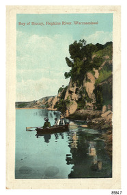
Postcard - Scenic, Warrnambool, Bay of Biscay, Hopkins River, Warrnambool, 1902-1910
The nine postcards in this set were donated together and date to the early 1900s. All but one postcard in this set shows images of Warrnambool, in the Western District of Victoria; the other has a London image. The postcards were all printed in Great Britain according to that country’s postal regulations. The fronts of all cards have titles printed in red. Most of the images on the cards are attributed to photographer Joseph Jordan and belong to the Jordan Series. The back of these cards has an outline for a postage stamp, a vertical dividing line and a heading on each side of the line to separate the Correspondence from the Address. Postcards or ‘correspondence cards’ appeared in Britain in 1894. They were plain cards with a space for the message on one side and an address on the other; regulations didn’t allow anything but the address to be written on the ‘address’ side. In 1902 the British regulations then allowed a picture to be printed on the front and the address on the back, so messages had to be written on the picture side. Soon, the regulations changed and the back was divided for a message and the address. Bay of Biscay, Hopkins River, Warrnambool – This same image was published in Table Talk on January 6th, 1910 and in The Age, on December 18, 1929, referred to a revival of fishing at the Bay of Biscay on the Hopkins River. These and similar articles showcased the Bay of Biscay as a popular boating and fishing location and well worth promoting to places outside of Warrnambool. Joseph Jordan - Joseph Jordan was born in 1841 in Leicester England. When he was 16 he joined the 7th Queen's Own Hussars and was sent to India at the outbreak of the mutiny. He took part in the relief of Lucknow and remained in India for eleven years. It was during this time that he became interested in photography. He was posted to New Zealand and later came to Victoria, becoming a sergeant major of the Mounted Rifles. In the mid-1880s he came to the Western district where he was responsible for establishing units of the Mounted Rifles in various country towns such as Dunkeld, Mortlake, Panmure, Bushfield, Koroit etc. He resigned from the army in 1889 and set up a professional photography studio in Liebig Street, Warrnambool. He became very well known in the Western District for family photographs, official photographs of local councillors and groups as well as views of local scenery. In 1891 he photographed the wrecked barque ‘Fiji’ at ‘Wrecks Beach’ near Princetown. His business was taken over by his son Arthur around 1917. Joseph was a keen rifle shot and in 1924 he donated the "Jordan Shield" as a prize to the Victorian Rifle Association. He was made a "Life Honorary Member" of the Warrnambool Returned Soldiers League and in 1933 he was recognised as being the oldest living soldier in Victoria. Joseph died in 1935 aged 95.The image of the figures in a row boat on the river suggests that the location was a popular place to visit. The choice of subject for this postcard indicates the popularity of Warrnambool's natural environment as a tourist attraction at a time when ships called coastal traders brought passengers and cargo to the Port of Warrnambool from ports along Victoria's southwest coast. Joseph Jordan is a significant figure in Warrnambool history as he helped to establish early units of the Mounted Rifles (G Company) in local towns during the late 1880's and later, photographed local scenes, groups and citizens of early Warrnambool.Postcard, one of nine, portrait orientation, coloured print within a rectangle border with an impressed line around the image and a title in red. The picture shows three figures wearing hats in a rowboat on the bank of a river beside cliffs. There is no correspondence written on the card. The back has inscriptions and outlines for a postage stamp. Jordan Series, printed in Great Britain.Front, in red: “Bay of Biscay, Hopkins River, Warrnambool” Back in green: “Jordan Series” “POST CARD” “PRINTED IN GREAT BRITAIN” “For correspondence” “The Address only to be written here”flagstaff hill maritime museum, flagstaff hill maritime village, flagstaff hill maritime museum and village, maritime museum, warrnambool, great ocean road, warrnambool and district, warrnambool scenes, local scenes, views of warrnambool, joseph jordan, jordan series, jordan photography, postcard, souvenir, correspondence, cameo postcard, bay of biscay, fishing, boating -
 Orbost & District Historical Society
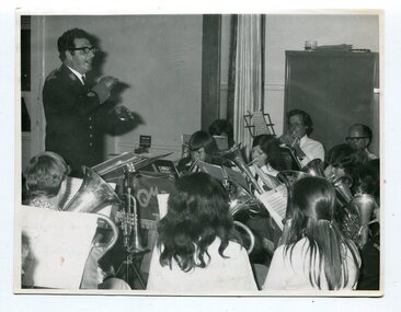
black and white photograph, November 1975
This photograph was taken inside St James Hall, Orbost at the 75th anniversary of the Orbost Municipal Band.on November 8, 1975. It was published in the Snowy River Mail on November 12, 1975 under the heading "ANNIVERSARY FOR BAND". "Some 250 people filled St James Hall on the occasion of the 75th anniversary of the band, The evening began with a buffet dinner followed by a recital by the members of the band, The fitting numbers chosen were favourites throughout the different eras during the band's 75 years. A display of old brass instruments, photographs and a history of the band drew much comment. Bandmaster, Alf Barling, conducted the band during the celebratory recital." The first Orbost Brass Band was formed in 1889. Around 1908 the town band split and the Orbost Workers' Band was formed. Eventually the two bands merged in 1913 to reform as the Orbost Municipal Band under conductorship of Charles Spink. The band continued for many years but was later disbanded and again reformed. This was to happen a number of times, the last time being in 1961 and continuing through to the late 1970's. Further info and Ref: In Times Gone By - Deborah Hall This is a pictorial record of the Orbost Municipal Band. The various Orbost bands over the years played a major role in community activities providing entertainment and musical experiences for the many members.A black / white photograph of a bandmaster in uniform standing, conducting, in front of a group of musicians.sitting down playing their instruments. The photograph has been taken indoors. music-orbost recreation orbost-municipal-band barling-alf entertainment -
 Myrtleford and District Historical Society
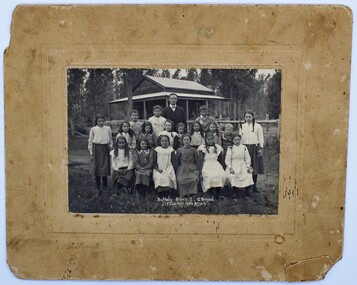
Photo, F.Foxcroft, Buffalo River South State school, 1913
1913 School photo of Buffalo River South State School. The school was 21 Km south of Myrtleford. 1913 Five members of the Fletcher family attended the school : Middle Row: Agnes (far left),Elizabeth(3rd from left ) Bruce (2nd from Right)Jeanette (far right), Front Row: Jean (2nd from left) Head Master: Mr Septimus Elmore Reference from 'Recollections IV ' (The Myrtleford & district Historical Society Inc February 2011) School photo of a remote school which was greatly impacted by fluctuating enrollments ,threatening its ongoing existence. the importance of numbers from single Family. clothes worn at this time Rectangular beige stained cardboard with an inserted emboss border surrounding a Sepia color photo. Buffalo River S.S. School. F.Foxcroft photo Brightmyrtleford,victoria,buffalo river, school, fletcher 1913 -
 National Wool Museum
Book, Dalgety: the romance of a business
"Dalgety: the romance of a business" - Wynford Vaughan-Thomas, 1984. History of the woolbroking and merchant firm of Dalgetys, now Wesfarmers Dalgety Limited.wool brokering wool sales, dalgety and company limited, wool brokering, wool sales -
 Tarnagulla History Archive
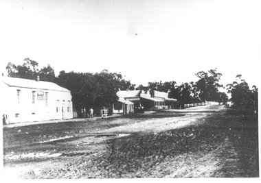
Photographs: Buildings in Newbridge near Loddon River bridge, Buildings in Newbridge near Loddon River bridge, 1908 (original image)
Depicts at left, Petersen's bakery, a store shed, Simpson's storekeepers and Simpson's Hotel. Hollands blacksmith shop & wheelwrights on right opposite bakery. Murray Comrie Collection. Three copies of a monochrome photograph, image depicts buildings in the eastern approach to the Loddon River bridge at Newbridge This is a fairly dark copy of an older original. Copy probably made by Murray Comrie in the 1960s.newbridge, loddon river, bridge, shops, stores, businesses, hotels, simpsons, petersens, bakery -
Stawell Historical Society Inc
Archive - Books & Papers, Ken Hyslop, Campbells Bridge Back to 1991, 1991
Associated with Back to Campbells Bridge and writing of Campbells bridge development and Social History 1861 - 1991. By Ken HyslopRecords relating to Campbells Bridge back to 1991. Plus Back to sign in bookVisitors Booksocial history -
 Kiewa Valley Historical Society
Photo - Tawonga Bridge.( Set of 2 photos)
Photo 1 - Rene Roper (Postmistress) crossing swollen Kiewa River on a milk can flying fox at Tawonga, during high winter waters Photo 2 - First Tawonga bridge was built in 1884- destroyed by floods in 1916. New bridge constructed 1923 and destroyed in 1953. Present concrete bridge constructed in 1986 and named Ryders BridgeBridge construction over Kiewa River at TawongaCopies of two original black and white photos. Photo 1 - Flying fox at site of Tawonga Bridge over the Kiewa River Photo 2 - Timber pile bridge over the Kiewa River at Tawongatawonga bridge, kiewa valley -
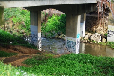 Greensborough Historical Society
Photograph - Digital image, Marilyn Smith, Railway Road Rail Bridge over Plenty River Briar Hill, 17/09/2014
Para Road bridge over Plenty River Greensborough, showing graffiti on bridge supports.Digital copy of colour photographpara road greensborough, plenty river -
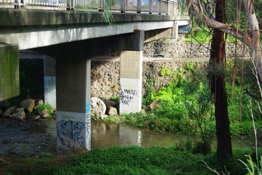 Greensborough Historical Society
Photograph - Digital image, Marilyn Smith, Railway Road Rail Bridge over Plenty River Briar Hill, 17/09/2014
Para Road bridge over Plenty River Greensborough, taken from the banks of the river.Digital copy of colour photographpara road greensborough, plenty river -
 Greensborough Historical Society
Photograph - Digital image, Marilyn Smith, Railway Road Rail Bridge over Plenty River Briar Hill, 17/09/2014
Para Road bridge over Plenty River Greensborough, taken from the banks of the river.Digital copy of colour photographpara road greensborough, plenty river -
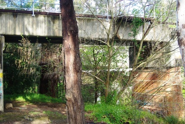
 Eltham District Historical Society Inc
Slide - Photograph, Russell Yeoman, Para Road / Carter Street Bridge over the Plenty River, Briar Hill, c.Jul 1969
Bridge over the Plenty River at Briar Hill before widening and alterations. The Plenty River at Briar Hill represented the boundary between the Shire of Eltham and the Shire of Diamond Valley. The bridge was known as the Carter Street Bridge as prior to 1969 Para Road, Briar Hill became Carter Street, Greensborough across the river. It was at this time that the name Para Road was continued and replaced Carter Street.35mm colour positive transparency blue Agfacolour Service plastic mount1969-07, briar hill, carter street bridge, para road, para road bridge, shire of diamond valley, shire of eltham, bridge, plenty river, shire of eltham pioneers photograph collection -
 Eltham District Historical Society Inc
Negative - Photograph, Russell Yeoman, Para Road / Carter Street Bridge over the Plenty River, Briar Hill, c.Jul. 1969
Bridge over the Plenty River at Briar Hill before widening and alterations. The Plenty River at Briar Hill represented the boundary between the Shire of Eltham and the Shire of Diamond Valley. The bridge was known as the Carter Street Bridge as prior to 1969 Para Road, Briar Hill became Carter Street, Greensborough across the river. It was at this time that the name Para Road was continued and replaced Carter Street.This photo forms part of a collection of photographs gathered by the Shire of Eltham for their centenary project book,"Pioneers and Painters: 100 years of the Shire of Eltham" by Alan Marshall (1971). The collection of over 500 images is held in partnership between Eltham District Historical Society and Yarra Plenty Regional Library (Eltham Library) and is now formally known as the 'The Shire of Eltham Pioneers Photograph Collection.' It is significant in being the first community sourced collection representing the places and people of the Shire's first one hundred years.Digital image 35 mm B&W negativeshire of eltham pioneers photograph collection, briar hill, 1969-07, bridge, carter street bridge, para road, para road bridge, plenty river, shire of diamond valley, shire of eltham -
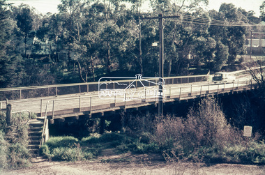
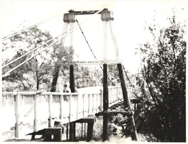 Kew Historical Society Inc
Photograph - Photograph (copy), Kanes Bridge, Studley Park, 195-1955
In 1928 a footbridge was erected to link Kew with the public golf course across the Yarra. The total cost of construction came to 250 pounds and the bridge became known as Kane's Bridge. During the 1934 floods the bridge was washed downstream, and was subsequently rebuilt. The present form of the bridge resembles the earlier bridge which crossed from the Yarra Bend Asylum to Kew, further upstream. (VHD)This work forms part of the collection assembled by the historian Dorothy Rogers, that was donated to the Kew Historical Society by her son John Rogers in 2015. The manuscripts, photographs, maps, and documents were sourced by her from both family and local collections or produced as references for her print publications. Many were directly used by Rogers in writing ‘Lovely Old Homes of Kew’ (1961) and 'A History of Kew' (1973), or the numerous articles on local history that she produced for suburban newspapers. Most of the photographs in the collection include detailed annotations in her hand. The Rogers Collection provides a comprehensive insight into the working habits of a historian in the 1960s and 1970s. Together it forms the largest privately-donated collection within the archives of the Kew Historical Society.A photographic copy of an older photograph of Kanes Bridge."Kanes Bridge"kanes bridge, yarra river, bridges - kew (vic.) -
 Eltham District Historical Society Inc
Photograph, Doug Orford, Completion of bridge works across Yarra River at rear of Eltham Lower Park, July 2004
Bitumen shared pathway under construction at the new Eltham-Templestowe footbridge over the Yarra River off Homestead Road, Eltham which was completed in July 2004. The Yarra River Footbridge was opened in August 2004 and links the Diamond Creek Trail between the Shire of Nillumbik and City of Manningham. It is a shared pathway and also links with the Main Yarra Trail. It affords lovely views over the Yarra River.Three colour photographs showing commencement of construction of Eltham-Templestowe footbridge over Yarra River off Homestead Road, Eltham which was completed July 2004. Third photograph of dedictaion plaque at opening 30 Aug 2004bridges, yarra river, eltham south, eltham lower park, lenister farm, homestead road, asphaldt, bitumen, shared pathway, diamond creek trail -
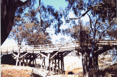 Stawell Historical Society Inc
Photograph, Old Wooden Bridge - over the Wimmera River at Joel Joel -- Coloured
Wooden Bridge - Joel Joel (Wimmera River) stawell shire -
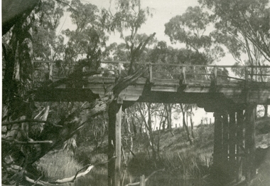 Stawell Historical Society Inc
Photograph, Old Campbells Bridge over Wimmera River
Old Campbells Bridge over Wimmera Riverstawell shire -
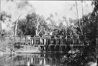 Stawell Historical Society Inc
Photograph, Weir on the Wimmera River between Glenorchy & Campbells Bridge -- Postcard
Weir on Wimmera River between Glenorchy & Campbells Bridgestawell -
 Stawell Historical Society Inc
Photograph, Wooden Wimmera River Bridge at Glenorchy -- 2 Photos
Two photographs of Wooden Wimmera River Bridge at Glenorchystawell -
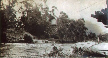
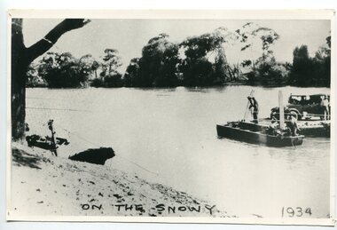 Orbost & District Historical Society
black and white photograph, 1934
This photograph shows vehicles and people being ferried across the Snowy River during the 1934 flood. The Orbost punt was reinstated on a temporary basis following damage to the bridge. Damage estimated at £500,000 was caused by the 1934 floods in the Orbost district. This 1934 flood was devastating, destroying a section of the 1922 Orbost bridge, wrecking fences, bridges and roads, dumping silt and debris on the rich river flats and drowning cattle. The centre span of the Orbost Bridge was washed away.This is a pictorial record of the effects of the 1934 floods in the Orbost district.A large black / white photograph of a punt with a motor vehicle and people making their way across a river.on front - "On the Snowy 1934"snowy-river-orbost flood-1934 river-transport-punt -
 Greensborough Historical Society
Photograph - Digital image, Old Bridge, Plenty River, 1911c
Photograph of old bridge over Plenty River, date unknown.Digital copy of black and white photograph.plenty river -
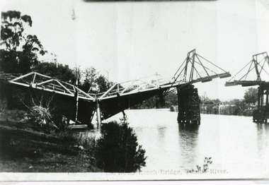 Lakes Entrance Regional Historical Society (operating as Lakes Entrance History Centre & Museum)
Photograph, Bulmer H D, 1925
Swan Reach Bridge collapsed 10.00 am 16 November 1925Black and white photograph showing collapsed bridge over the Tambo River, bridge collapsed at eastern end. Photo looking downstream. Two people on landing on far right bank behind right hand bridge pylon. Thick vegetation on bank. Swan Reach VictoriaSwan Reach Bridge on the Tambo Riverwaterways, boats and boating -
 Greensborough Historical Society
Photograph - Digital image, Frank Solomon, View over Greensborough to Plenty River Drive bridge, 2010c
View over trees to the Greensborough By-pass bridge over Plenty River Drive.Digital copy of colour photographplenty river drive, greensborough bypass -
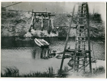 Orbost & District Historical Society
black and white photographs, 1915
This photograph is of the construction of the first road bridge over the Genoa River - 1915. Before today's timber truss and concrete bridge was constructed between 1926-1928 by contractor J.T. Noble Anderson, two earlier bridges crossed the Genoa River at this location. They provided crucial links in the Princes Highway route from Melbourne to Sydney. The letter on the back of the postcard was written by Gordon ? to Alex ? on 2nd October 1917. "this represents the opening of Genoa Bridge. Mrs Alexander cutting the ribbon and Mr Martin holding it at the other side. Did most of the speaking. The gent holding the roll of paper is who came to open the bridge. I can't think of his name. Hubert is standing up at the right / Gordon " This is a pictorial record associated with the history of Genoa in East Gippsland.1100 -A large black / white photograph on a cream coloured buff card. It is of an unfinished bridge with men working there. A small rowboat can be seen on the far side of the river. 1100.1 - A photograph / postcard of the opening of "Genoa Bridge 1917". There is a ribbon stretched across the timber decking road in front of a group of people. 1100.2 - A black / white photograph of a road bridge across a river.on back - "Princes Highway - the 1st bridge over the Genoa River - 1915" on back of 1100.1 is a hand-written letter.genoa-bridge princes-highway-east-gippsland -
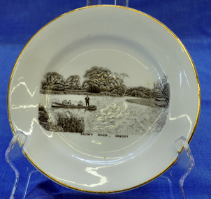 Orbost & District Historical Society
souvenir plate, Between 1925 and 1941
Illustration on plate is a family fishing party aboard the "Ripple" built by George Matthew Winchester. Shows Ethel (mother) with Lindsay Smooker on her knee. Harry, Elsie, Anita and H. Hermann about 1941. The Winchesters lived in Marlo and built boats near the Marlo hotel. The "Ripple" built by George Winchester at the age of 18 years was the first boat built by him. It was built in 1908. It has been noted in a profile of George Winchester done by his Daughter Olive Hunt (née Winchester) that was completed one year before her death in 2002.The Winchester family is a prominent local family.The Winchesters lived in Marlo and built boats near the Marlo hotel. This item is an example of a souvenir item made especially for Orbost.Very small white souvenir plate. Gold-rimmed with black illustration of people in a boat on the Snowy River.Front-Snowy River Orbost Back-Melba Bone China Guaranteed Made in Englandplate souvenir snowy-river orbost melba-china -
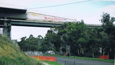
 Greensborough Historical Society
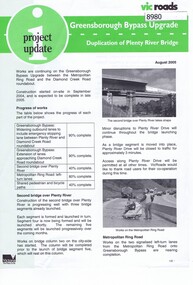
Newsletter, Vic Roads, Vic Roads , Greensborough Bypass Upgrade - Duplication of Plenty River Bridge, August 2005
Vic Roads Newsletter regarding the Greensborough Bypass Upgrade and duplication of the Plenty River Bridge.2 page Newsletter with print and black & white photosgreensborough bypass, vicroads, plenty ri, plenty river bridge -
 Ringwood RSL Sub-Branch
Souvenir Framed item, Piece of bridge from the Burma Railway, C 1987
Wooden frame with text and a piece of teak from the Bridge over the River Kwai.Collected from the bridge on 10th March 1987. -
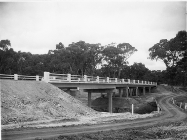
 Greensborough Historical Society
Photograph - Digital image, Frank Solomon, Plenty River Drive Bridge Roadworks 1, 1995c
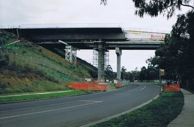
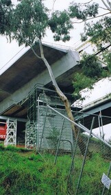
These photos show the duplication of the bridge over Plenty River Drive on the Greensborough Bypass, circa 1995.Digital copy of colour photographplenty river drive, greensborough bypass -
 Greensborough Historical Society
Photograph - Digital image, Frank Solomon, Plenty River Drive Bridge Roadworks 3, 2005c
These photos show the duplication of the bridge over Plenty River Drive on the Greensborough Bypass, circa 2005.Digital copy of colour photographplenty river drive, greensborough bypass -
 Greensborough Historical Society
Photograph - Digital image, Frank Solomon, Plenty River Drive Bridge Roadworks 4, 2005c
These photos show the duplication of the bridge over Plenty River Drive on the Greensborough Bypass, circa 2005.Digital copy of colour photographplenty river drive, greensborough bypass -
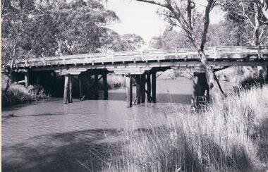
 Stawell Historical Society Inc
Photograph, Campbell’s Bridge over the Wimmera River 1961
Newly built Campbell’s Bridge over the Wimmera River. Built by Redman Bros. Opened in 1961.stawell shire