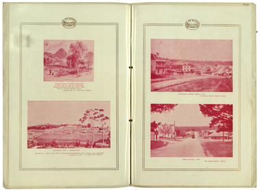
Showing 277 items
matching foundations
-
 Bendigo Historical Society Inc.
Document - VICTORIA HILL - ABRIDGED SIGNS FOR VICTORIA HILL
Handwritten carbon copy of notes with typed copy of same, for signs on Victoria Hill. Signs mentioned are: Ballerstedt's First Open Cut,20 Head Crushing Battery, Victoria Quartz Mine, Victoria Quartz Foundations of Steel Poppet Legs, Coloured rock formations, Primitive tunnels, Adit, Engine Beds Lansell's Big 180 Mine, Anticlinal Arch, Coloured rock formations marking and patterns. Notes prepared by Albert Richardson.document, gold, victoria hill, victoria hill, abridged signs for victoria hill, ballerstedt's first open cut, 20 head crushing battery, victoria quartz mine, victoria quartz foundations of steel poppet legs, coloured rock formations, primitive tunnels, adit, engine beds lansell's big 180 mine, anticlinal arch, coloured rock formations marking and patterns -
 Federation University Historical Collection
Book, William Henderson, If, and What? Lectures on Theism, 1882
Brown hard covered book of 257 pages published in 1882. Includes a line drawing of William Henderson. If. and What? is twelve lectures on the foundations of Christian Theism. The lectures are: 1. God and World - One or Two 2. Possibility of a Scientific Theism 3. Aetiology, or origin of cause 4. Teleology, or Source of Purpose 5. Theology of the conscience, or Fountain of Morality 6. Ontology, or God as Supreme Being 7. origins of Religion 8. Self- Limitation of the Infinite 9. God as father 10. The Divine Infinite and the Divine Love 11. God in Christ 12 Alpha and Omega The last paragraph of the preface states: "If this little book of mine can only show that theology has nothing to fear from all the science that is going, thal all true theologeans are just as eager as their neighbours to learn all that science has to teach them, in assurance that it will only make the foundations of their faith more stable and secure in the end, then it will not have been given to the world in vain. sic prosit." non-fictionreligion, ballarat, rev. henderson, william henderson, theism, aetiology, telelogu, yheology, conscience, ontology, self-limitation, god as father, divine infinite, divine love, alexander kelly -
 Bendigo Historical Society Inc.
Magazine - AILEEN AND JOHN ELLISON COLLECTION: WALKABOUT MAGAZINE 1966
Walkabout magazine special annual issue December 1966. Price 50 cents. On the cover a view of the Olgas and at bottom presenting: "this Australia" big colour section. The magazine has 84 pages. Contents: Mail bag - Publisher's column - 1966 and all that - The small world of Jamesy rice - modern miners dig foundations of new Australia - Christmas Day - This Australia - Holiday, Australian style - Pages turned by children - Charlie delta tango - On the move - book reviews.book, magazine, travel -
 Kiewa Valley Historical Society
Photograph Rocky Valley Dam Excavations, Rocky Valley Dam Wall Excavation, c1947-48
Work commenced at Rocky Valley Dam site in early 1947 and proceeded until May. Resumed work in October after the winter and a camp for the accommodation of workmen was commenced at this time. Work continued in 1948 with the establishment of work facilities, including the erection of two large excavators. At the dam site the river was diverted through a temporary pipeline. Work proceeded in the summer months with the placing of concrete in the foundations and earth and rock fill for the construction of the wall. Rocky Valley and associated spillway and outlet works were completed in March, 1959. A very good representation of the type of machinery available in the 1940's used for excavation of the dam and the construction of the dam wall.Black and white photograph of Rocky Valley Dam wall under construction. There are at least three cranes plus workmen in the photo. This is taken from the Heathey's Spur side of the dam wall looking back toward Sun Valley.Hand written on back of photograph "Rocky Valley Dam Wall Excavation" in blue ink.rocky valley, dam, wall, machinery -
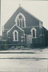 Uniting Church Archives - Synod of Victoria
Photograph, undated
The memorial stone of the UMFC in Church St. Richmond was laid in December 1868. The bluestone church, which seated 308 people, was designed by G.R. Cox and built by John Wright. It was opened in May 1869. By 1890 subsidence in the foundations of the building had caused the bluestone façade to bulge dangerously outwards and a new façade of red and white brick was constructed. The memorial stone of the new façade was laid on 7th June 1890. Before construction of the 1868 church, services were held in a weatherboard building which subsequently served as the Sunday School.B & W photograph of the exterior of the Richmond United Free Methodist Church.united free methodist church, church street richmond, bluestone, g.r. cox, john wright. -
 Bendigo Historical Society Inc.
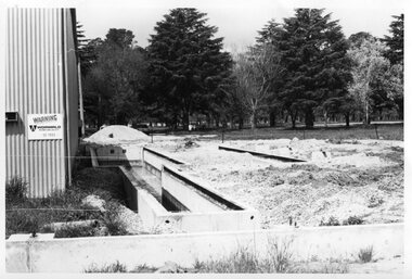
Booklet - Victoria Hill
Victoria Hill, accessed from Marong Road, was one of the richest areas on the Bendigo goldfields and was the beginning of reef mining as opposed to alluvial mining. Between 1853 and 1861 there were 16 claims registered on Victoria Hill. Between 1908 and 1910 it was the site of the world's deepest shaft (1365-1406 meters)Today it provides interpretive walks that include sites such as an open-cut mine (1850's), poppet head, quartz crushing battery (1930's) and the foundations of George Lancell's 180 mine. It is registered as a site of historical significance.Clear plastic cover spiral bound booklet of 25 pages. 'Victoria Hill'. A historical background of Victoria Hill and the surrounding area. A colour photo of a poppet head on front. Original story written by Albert Richardson in 1971. This is a revised edition by Philip Wilkin in 2012. Illustrated with colour and B&W photos. Pages 13 to 25 have been inadvertently inserted upside down. A single page A4 leaflet 'Victoria Hill Self Guided Tour' has been put inside after page 1Handwritten in ink on front page 'Donated to Specimen Cottage'victoria hill, gold mine -
 Surrey Hills Historical Society Collection
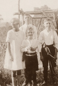
Photograph - Digital photo, 1922-1925
Alan Judge Holt (1912-1993), Frederick Sutton Holt (1914-1992) and Raymond James Holt (1918-2000) were the children of Edmund Holt (1881-1945) and Ruby Ellen Sutton (1889-1961). The family had multiple associations with Surrey Hills, in particular the Surrey Hills Methodist Church. Associated homes were in Beatrice Avenue and Broughton Road. Alan Judge Holt became secretary of the Victorian Lands Department and his meticulous research laid the foundations of the SHNCHC. The relationship of Dot to the family needs clarification. The Holt family held many connections with the local Surrey Hills community with Alan Holt's research a valuable part of the Surrey Hills Heritage Collection.A digital copy of a sepia photo with 4 children in a garden setting - Dot, Alan, Ray and Fred Holtchildren, siblings, family portrait -
 Bendigo Historical Society Inc.
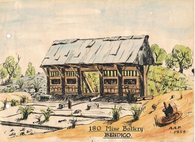
Painting - 180 MINE BATTERY
The remains of the 180 mine battery as painted by Alfred Perry in 1959. This is a watercolour and indian ink sketch on card. Yellow card attached with painting states: ' George Lansell Exhibit No 4. The remains of the 180 mine battery as painted by Alfred Perry in 1959. It was from the 180 that George Lansell laid the foundations of his fortune and indeed the fortunes of the district. With his capital behind the field mining flourished for nearly one hundred years and ensured employment for the many miners in the district.'Alfred Perryartwork, print, mining heritage, alfred perry, mining battery, 180 mine, victoria hill -
 Ballarat Tramway Museum
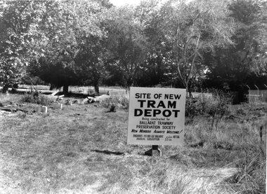
Photograph - Black & White Photograph/s, The Courier Ballarat, 2/4/1972?
Yields information about the commencement of construction of the BTPS depot in the south Gardens reserve and seeking new members.Black and White copy photograph of a newspaper photograph taken by The Courier of The sign marking the site of the BTPS depot, with the first of the foundations installed. Photo taken Saturday 1 or 2/4/1972?, published 3/4/1972. See Reg. Item 2193 for the photo used in the newspaper clipping. Collected by Alan Bradley from the Ballarat Courier early 1980's. See Excel file "Record of Ballarat Courier Photos BTM era" (Archive Documents) for source of details.On rear stamped "Copyright, The Ballarat Courier Proprietary Limited."tramways, trams, btps, depot, gardens, signs -
 Wodonga & District Historical Society Inc
Album - Hume Reservoir Australia Album - Plans and Progress Photos - River Murray Water Scheme, Department of Public Works, N.S.W, 1927
This set of photos is from a leather bound album bearing the inscription "HUME RESERVOIR AUSTRALIA" plus 'The Rt. Hon. L. C. M. S. Amery, P. C., M .P.' all inscribed in gold. It was presented to The Rt. Hon. L. C. M. S. Amery, P. C., M. P, Secretary of State for Dominion Affairs on the occasion of his visit to the Hume Reservoir on 2nd November 1927. This album is of local and national significance as it documents the planning and development of the Hume Reservoir up to 1927. It was the largest water reservoir in the British Empire. The album records the pioneering engineering work that went into its construction.1. Locality Plan and Plan of Dam. The dam is about ten miles by road upstream from Albury and about three-quarters of a mile below the confluence of the Mitta Mitta River and the Murray River. Its main features consist of a concrete portion across the bed of the river with earth embankment at both ends. The foundations throughout are on hard granite, found at an average depth of about 40 feet below the surface, the centre line being located to take advantage of the most favourable rock levels.Heading on page "WORKS UNDER RIVER MURRAY WATERS AGREEMENT/HUME RESERVOIR" Beneath top diagram "FIG. 1. ELEVATION" Beneath second diagram "FIG. 2. PLAN" On map "LOCALITY PLAN"hume reservoir australia, river murray waters scheme, hume weir diagrams, hume weir location -
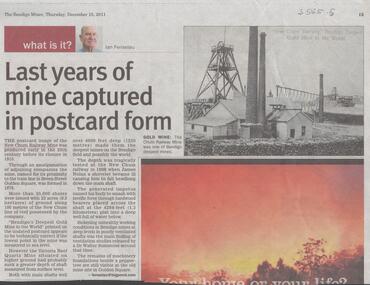 Bendigo Historical Society Inc.
Newspaper - NEW CHUM RAILWAY MINE - LAST YEARS OF MINE CAPTURED IN POSTCARD FORM
Newspaper article titled 'Last Years of Mine captured in Postcard Form' from the Bendigo Miner, Thursday, December 15, 2011 by Ian Fenselau. Article mentions some history of the mine, how it got it's name, depth of the mine and it's comparison with the Victoria Reef Quartz. It also mentions the death of James Nolan when he fell down the shaft and studies of ventilation released by Dr Walter Summons. The machinery foundations are still visible in Golden Square.newspaper, bendigo, the bendigo miner, new chum railway mine, last years of mine captured in postcard form, ian fenselau, victoria reef quartz mine, james nolan, dr walter summons -
 Eltham District Historical Society Inc
Folder, Nillumbik Community Profile, 1998
Based on 1996 Census - Snapshot of the Nillumbik community sourced from "Melbourne in Fact" Department of Infrastructure, 1998. Pages 66-67. File also includes un-connected information including part photocopy of unsourced newspaper article headed: Eltham special: Complete services availalbe in Eltham's modern business centre, Josiah Holloway (laid) the Foundations and copy of old photograph in the collection headed "Main Road, Eltham". News clipping headed "New guide to area history" from Diamond Valley News 5 May 1999.3 photocopied pages. I original news clippingHG Booklet 27chronology, harry gilham collection, shire of nillumbik -
 Stawell Historical Society Inc
Photograph, Extensions to Medical Centre 1985, c 1985
7130: Gunnings house prior to removal fro Constuction of Medical Centre. 7130-1: Old home in Wimmera St Remved for McCrackens used car yard. 7130-2: Dr. Andrew Cunningham looking at the constrution of the extensions to the Stawell Medical Centre. 7130-3: New Enterance to the Stawell Medical Centre. 7130-4: A Veiw of the partially completed extension to the SMC from Across the road. 7130-5: Slab Finished building under construction, town hall in background. 730-6 Brickwork and Timber truss's on new additions. 7130-6: Work Just Beginning. 7130-7- Old entrance to the SMC. 7130-8- the new additions to the SMC. 7130-9: 7130-10 & 11 1987 Extension. 7130 15 & 16 c 1980 Stawell Medical Centre Cnr Wimmera Scallan St. 71340-17: C 1985 Back entrance 7130-19 c1985 After removal of Gunnig house. 7130-20 c1985 Extension under way. 7130-21 Preparation of Foundations 7130-22 Medical Centre Extensions 7130-23 Extensions 7130-24 Foundations being dug 7130-25 Building underway 7130-26 Sue Cunningham and Meg in front of Stawell Medical CentreTwo B/W & 13 Colour Photographs in Plastic Pockets.medical -
 Federation University Historical Collection
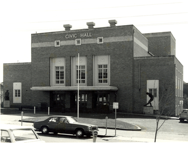
Photograph - Photograph - Black and White, Ballarat Civic Hall, c1965
The City of Ballarat unanimously resolved to erect a Civic Hall in 1951. The architects, Gordon Murphy, of Melbourne, and H.L. and L.J. Colburn, of Ballarat, were commissioned in 1952. The Council constructed the foundations and footings for the building under the supervision of the former City engineer, Mr L.H. Finch, in 1953. These footings are of massed concrete. The design for the building took advantage of the cross fall of the land, providing for the Small Hall to be entered from the Doveton Street frontage through a foyer under the Main Stage, the structure is steel with brick panels, with accommodation for 1,592 persons in the Main Hall and 440 persons in the Lower Hall. Black and white photograph of a brick building known as Ballarat Civic Hall. It is located on the corner of Mair Street and Doveton Street North. The Shakespeare statue out the front of the building was unveiled on 17 November 1960. ballarat civic hall, civic hall, colburn, finch -
 Federation University Historical Collection
Booklet, John Fraser & Son, Shire of Buninyong, 1858-1958, 1958
Booklet of loose pages held together with yellow ribbon. Photographs of Buninyong.non-fictioncentenary, fisken, shire council, district road board, buninyong, 1958, dallas brookes, governor of victoria, archibald fisken -
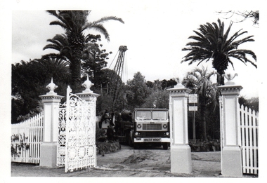 Williamstown Botanic Gardens- Hobsons Bay City Council
Photos - Cannons, 1970
The Armstrong Cannons were originally placed at Fort Gellibrand, located at the southernmost tip of the Williamstown peninsula. The Fort was developed during the 1850s as part of a defensive system for the city and port of Melbourne. The importance of the Fort batteries declined from the 1890s, when they were effectively replaced by new facilities at Queenscliff and Point Nepean, but they were still used for gunnery practice. Local residents, through the Williamstown Town Council, complained to the Acting Minister for Defence that the concussion from the guns damaged windows, walls and foundations of buildings. The Armstrong Cannons were moved from Fort Gellibrand to the Gardens in 1906. A primary source of evidence of the cannons being in the Gardens. The cannons are remembered fondly as play equipment for the local children. Many tales have been told of climbing over them and pretending to be shot out of them A collection of seven black and white photographs documenting the removal of the cannons from the Gardens Photo 1 (a) Black and white landscape image. View is looking through the main gates looking at the front of the truck, which has the name Walter Wright across the front bumper, the crane and canon. The gates and fence are painted a light colour, probably white. Photo 2 (b) Black and white landscape image. Back of loader with cannon on it. Man standing on top of the cannon bending over either tying or untying ropes. Trunk of a palm tree is on the left side of the photo with a top of a palm tree in the background. Photo 3 (c) Black and portrait white image. A cannon being loaded by the crane on to trailer. Palm tree is in the background and fronds from a palm tree can be seen in the right top corner. Photo 4 (d) Black and white landscape image. Side on view of a cannon on the truck parked outside the grounds of the Gardens. The logo of the name of the trucking company is on the door of the truck above the words ‘WALTER H WRIGHT / TRANSPORT PTY LTD / S SCHULZ ST WEST MELB’. A second cannon can be seen in the background. A bus is in the background on the middle right side of the image. Photo 5 (e) Black and white landscape image. Truck with cannon on the back leaving the ground of the Gardens. Tree on the right side of the image and power pole is behind the truck. The logo of the name of the trucking company is on the door of the truck above the words ‘WALTER H WRIGHT / TRANSPORT PTY LTD / S SCHULZ ST WEST MELB’. ‘WALTER WRIGHT’ is on the front bumper Photo 6 (f) Black and white landscape image. Cannon tied down on the back of the truck as it is being driven across the street. Three houses in the background and two cars, one is a Volkswagen Photo 7 (g) Black and white landscape image. Cannon on the back of the truck which is parked over the street from the Gardens. Three houses are in the background. Two trees bare of leaves. The front of a car in in the foreground – it has a sun visor and the steering wheel is a light colour.armstrong cannons, williamstown botanic gardens, hobsons bay city council, 1970, walter h wright / transport pty ltd -
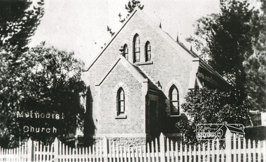 Eltham District Historical Society Inc
Photograph, Tom Prior, Methodist Church, Eltham
Situated at 810 Main Road on the corner of John Street. The Church was surrounded by a picket fence and tall pine trees. The Church was built by George Stebbings in the 1850s and is an example of fine craftmanship. Formerly Wesleyan, Methodist then Uniting church; the foundations of the church building were constructed with stone from the walls of the first Eltham State Primary School (No. 209) building which collapsed in 1874 and were purchased by Robert David Taylor. The Reynolds/Prior Photograph Collection, Presented to the Eltham District Historical Society, 14 June 2006 by Ross McDonald. A second copy was also presented to the Andrew Ross Museum, Kangaroo Ground The Reynolds family were early settlers in Research. Reynolds Road is named after this family. RERVISED STATEMENT OF SIGNIFICANCE, CONTEXT, 2010 What is significant? The 1880 bichromatic brick church and the surrounding site to the title boundaries. The church is architecturally, historically, socially and spiritually significant to the Shire of Nillumbik. Why is it significant? The church is architecturally significant as a finely detailed example of a brick 19th century rural community church, one of only four in the Shire (Criteria E & B). The church is historically significant as an important link with the time when Eltham was a small, insular country settlement. Also for the historical evolution visible in the complex, with the modest 1880s church and larger red brick rear hall from the early 20th century as a reflection of population growth in the area (Criterion A). The church is historically, spiritually and socially significant because it has played, and continues to play, an important part in the spiritual and social life of the community (Criterion G). - Victorian Heritage Database The Reynolds family were early settlers in Research. The Reynolds/ Prior collection of photographs were taken by Tom Prior, the maternal uncle of Ivy Reynolds, around 1900 and the 60 photos in the album give a fine overview of many of the landmarks of Research and Eltham over 100 years ago. lvy lived in the family home for many years at 106 Thompson Cres Research. Ivy's father, Ernst Richard Reynolds and grandfather, Richard Reynolds, lived at the same address. Ivy's father Richard worked for Mr. Trail on his property in Research. Reynolds Road is named after the family. Mr Tom Prior (wife Eva) worked at the Melbourne zoo. He was very innovative and made his own camera, using the black cloth hood to exclude the light. The photographs are a reminder of the rural nature of Research and Eltham and its rich heritage. Black and white photograph mounted in an album, the Reynolds/Prior Photograph Collection, this being one of 53 reproduced black and white images of early Eltham."Methodist Church" reynolds prior collection, eltham, methodist church -
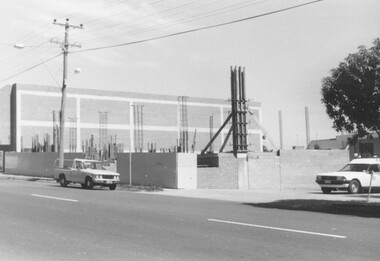 Ringwood and District Historical Society
Photograph, Building Construction: 27-29 Ringwood St, Ringwood. 1982 (2 views)
Written on back of photograph SS0245a: , "Framing the columns under the first floor of 27-29 Ringwood Street. Social Security buildings in background. Shows Waltons 'Blimp' in sky right of power pole. It was tethered over their store on highway. 25/3/82". On back of SS0245b: "Preparing the foundations of 27-29 Ringwood St. 25/3/82" -
 Ballarat Tramway Museum
Photograph - Black & White Photograph/s - set of 2, 1978
Yields information about the construction of the BTPS Depot in the Gardens.Black and white photograph of the two stages of the extension of the BTPS depot in 1978/1979. The first photograph shows the depot pits constructed and the building foundations in position. The second photograph of the first stage of the steel erection. Reference Annual reports - 1977 - 1978 - concrete finished except for backfiring. 1978 - 1979 - steel partially up - Christmas 1978, started November 1978. Photographer of item 2 (and may be other photos ex the album) was Graham Jordan - see history of the object. See BTPS Annual Reports, 1977-78 and 1978 - 1979.tramways, trams, btps, depot extensions, depot -
 Wodonga & District Historical Society Inc
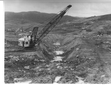
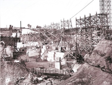
Album - Hume Reservoir Australia Album - Work proceeding inside the coffer dam (2), August 1927
This set of photos is from a leather bound album bearing the inscription "HUME RESERVOIR AUSTRALIA" plus 'The Rt. Hon. L. C. M. S. Amery, P. C., M .P.' all inscribed in gold. It was presented to The Rt. Hon. L. C. M. S. Amery, P. C., M. P, Secretary of State for Dominion Affairs on the occasion of his visit to the Hume Reservoir on 2nd November 1927. This album is of local and national significance as it documents the planning and development of the Hume Reservoir up to 1927. It was the largest water reservoir in the British Empire. The album records the pioneering engineering work that went into its construction.DEPARTMENT OF PUBLIC WORKS, N.S.W. RIVER MURRAY WATERS SCHEME. HUME RESERVOIR. 26. Work proceeding inside the coffer dam. This view was taken from the edge of the cut for the South Wing Wall foundations looking from the opposite direction to that of the preceding photograph, the curving downstream face of the main wall being seen beyond the steam navvy. This view shows the way in which the concrete paddocks are stepped and broken jointed vertically and horizontally. In the distance is the North Wing Wall and Power House stack beyond it. New South Wales, August 1927.hume reservoir australia, river murray waters scheme, hume reservoir construction -
 Bendigo Historical Society Inc.
Document - MARKS COLLECTION: SPECIFICATION AND GENERAL CONDITIONS OF CONTRACT HERCULES AND ENERGETIC MINE, 2nd March, 1870
Handwritten document, outlining 'specifications to bricklayers and stonemasons work required for the erection of Steam Engine, Boiler and Winding Gear for the Hercules and Energetic Goldmining Company, Sandhurst' Sections consist of details for excavation for engine and foundations, masonry, brickwork chimney, excavations for boiler seating, firing floor, firing boiler brickwork engine bed, winding gear, mortar and cement, seating of boiler. Document is dated Mar 12, 1870. Attached to the document is a blue printed 'General Conditions of Contract' document, handwritten on top 'Bricklayers' Drawings by Wm. Middleton, engineer. See 8300.14.Drawings by, Wm Middleton, Engineer Sandhursts.bendigo, buildings, fortuna villa, william middleton, hercules and energetic gold mine -
 The Beechworth Burke Museum
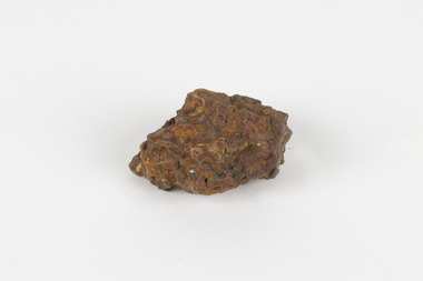
Geological specimen - Laterite
Laterite refers to both a rock and a soil type that is rich in clay, as well as Iron and Aluminium. It is created during a process that is called laterization, where high heat and seasonal heavy rainfall cause there to be wet and dry periods, which over time hardens the soil into rock. Because of this, most laterite is formed between tropics of Cancer and Capricorn. The iron oxide in laterite is what gives it it’s orange-red colouring. The largest religious complex in the world, Angkor Wat in Cambodia, is partially constructed of laterite, particularly its foundations, as laterite is porous and allows rainwater to drain. This specimen of laterite was collected from the Democratic Republic of Congo while it was colonised by Belgium in the 19th century. Laterite forms in many parts of the world, particularly between the tropics. It is used both for ore and as a building material, and comparing specimens from different parts of the world allows us to document the different compositions that this mineral can have when formed at different locations. This specimen is part of a larger collection of geological and mineral specimens collected from around Australia (and some parts of the world) and donated to the Burke Museum between 1868-1880. A large percentage of these specimens were collected in Victoria as part of the Geological Survey of Victoria that begun in 1852 (in response to the Gold Rush) to study and map the geology of Victoria. Collecting geological specimens was an important part of mapping and understanding the scientific makeup of the earth. Many of these specimens were sent to research and collecting organisations across Australia, including the Burke Museum, to educate and encourage further study.a palm-sized solid iron-aluminium oxide mineral specimen in shades of brown, orange and greyburke museum, beechworth, geological, geological specimen, laterite, laterite specimen, geology -
 Wodonga & District Historical Society Inc
Album - Hume Reservoir Australia Album - Work proceeding inside the coffer dam, August 1927
This set of photos is from a leather bound album bearing the inscription "HUME RESERVOIR AUSTRALIA" plus 'The Rt. Hon. L. C. M. S. Amery, P. C., M .P.' all inscribed in gold. It was presented to The Rt. Hon. L. C. M. S. Amery, P. C., M. P, Secretary of State for Dominion Affairs on the occasion of his visit to the Hume Reservoir on 2nd November 1927. This album is of local and national significance as it documents the planning and development of the Hume Reservoir up to 1927. It was the largest water reservoir in the British Empire. The album records the pioneering engineering work that went into its construction.DEPARTMENT OF PUBLIC WORKS, N.S.W. RIVER MURRAY WATERS SCHEME. HUME RESERVOIR. 25. Work proceeding inside the Coffer Dam. This shows the curving downstream face of the Spillway section taking shape, the bottom edge being the line of the contraction joint between the wall and the energy dissipater which has still to be built. Note the steam navvy at the end of the bit of curved work ready to take out the foundations for the energy dissipater. The tall concrete pillar is a portion of the work at the intersection of the main and south wing walls which was built in advance of the rest of the work to accommodate the tail tower of the cableway. The Tail Tower for the first stages of the work stood on the ground. Part of it is seen erected on the pillar while part of it is still in its original position. To command the concreting of the pillar end of the south wing wall a twin hoist tower of steel construction was erected at the end of the belt conveyor. This hoist is 160 feet high. The belt conveyor will at a later stage be raised for the concreting of the upper portion of the dam and the trestles are now being built up for that purpose. A drag line excavator with a 2 cubic yard capacity bucket is at work near the tail tower on the foundations for the south wing wall. New South Wales, August 1927.hume reservoir australia, river murray waters scheme, hume reservoir construction -
Federation University Historical Collection
Book, McGraw-Hill Book Company, Civil Engineering Handbook, 1940
Dark Green book of 877 pages,non-fictionengineering, rex hollioake, surveying, railway, highway, mechanics, hydraulics, framed structures, steel design, concrete, foundations, sewerage, water supply, purification -
 Bendigo Historical Society Inc.
Document - THE BEGINNINGS OF: LOCAL GOVERNMENT IN SANDHURST 1855 TO 1856
''The Beginnings of Local Government in Sandhurst 1855-1856'' (- author Marianne Diedrich). Mention of Angus Mackay, Robert Ross Haverfield, James Forrester Sullivan, Edward Nucella Emmett,George Washington Haycock, H. Neale, D M Donegal, Shadrach Jones, W L Harris ('Yanky Sam'), John Harney, E. Bissell, Alfred England, Mr Hopkins, George Avery Fletcher, Mr Pitman (Solicitor), John Roach, Cr. Haycock, Detail of early function of meetings, rates, public meeting. Author claims the 1856 council to be 'tenacious' and laid foundations for improvements. Includes reference.Marianne Diedrichbendigo, council, city of sandhurst, george avery fletcher, mr pitman, john roach, cr. haycock, mr hopkins, angus mackay, robert ross haverfield, d. bissell, alfred england, shadrack jones, james forrester sullivan, d. m. donegal, w. l. harris, edward emmett. -
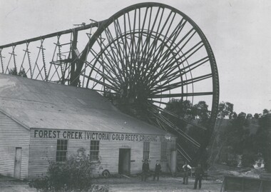 Bendigo Historical Society Inc.
Photograph - FOREST CREEK GOLD MINES CRUSHING BATTERY AT CHEWTON, c.1890
Black and white photograph. Forest Creek (Victoria) gold reefs crushing works. The Garfield overshot waterwheel which drove the battery at Chewton. Inscriptions on back: 'MNG 31''Garfield Mine, Chewton, J Ebbett, Manager' ( in top LHC), 'Royal Historical Society of Victoria, Bendigo Branch' (in circular rubber stamp). History of object: Previous ACC. No. 'MNG 31', Ralph Birrell 5.11.1999 'Garfield Waterwheel and Crushing Mill, Chewton:' Gardield overshot waterwheel which drove the Forest Creek Gold Mines crushing battery at Chewton. The foundations of this wheel can still be seen today.Bendigo Advertiserbuildings, commercial, garfield waterwheel at chewton -
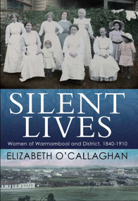 Warrnambool and District Historical Society Inc.
Book, Silent Lives: women of Warrnambool & district 1840-1910, November 2017
Warrnambool has never done justice to the women who shared their menfolk the hardships of the pioneering days. Silent Lives fills a void in the history of Warrnambool and surrounding districts, during the early decades 1840s to 1910, providing a narrative about some of the people, in particular women, missing so far in our documented history. Elizabeth O'Callaghan has meticulously researched the period, drawing on early newspapers, diaries, letters, unpublished family histories, honour board listings as well as public documents such as hotel licensing and teacher records held in the Public Record Office of Victoria and State Library of Victoria. By their unremitting labours and self-sacrifice the pioneering women of Warrnambool and district helped to lay the foundations of our communities today.This publication is of significance as it documents the lives of 19th century women in Warrnambool and district between 1840 and 1910 covering Aboriginal women, schools and teachers, specialist teachers of art, writing and cookery, sporting activities, political and charitable activities, how the law treated women, medical treatment, and the everyday lives of women and their families. It contains images of art produced by some of these women.A4 size book with photograph of 7 women and 3 children in c1890sworking clothing and long white aprons, sitting and standing in front of a hedge with washing draped over the hedge. The two girls on the right are wearing wide-brimmed hats. The title is in white print on a band of dark blue across the middle. The bottom third features an early image of Warrnambool and the author's name in dark blue.Elizabeth O'Callaghan/November 2017warrnambool, history of warrnambool, 19th century women, women pioneers, silent lives, elizabeth o'callaghan, cover design james colquhoun -
 Ballarat Tramway Museum
Photograph - Colour Photograph/s, Carolyn Dean, 29/01/2000 12:00:00 AM
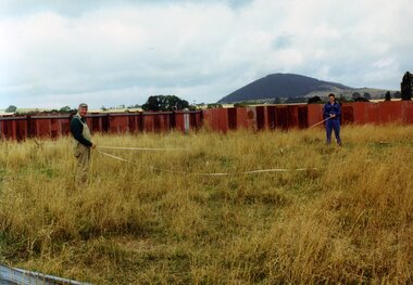
Set of seven colour photographs of initial work in the construction of the off site storage buildings at Bungaree. Taken by Carolyn Dean on 29/1/2000 and 30/1/2000. On Kodak paper. .1 > .3 on 29/1, rest 30/1 1347.1 - John Phillips and Alastair Reither setting out the foundations pegs. .2 - Foundation pegs in. .3 - ditto .4 - Mowing the grass (jungle) - John Phillips and Jim Parker. .5 - the sheep watching the grass go. .6 - the site from the south end. .7 - ditto from the north end.` See Fares Please! March 2000.All have on rear in black ink "29.1.00 or 30.1.00 / Photo by Carolyn Dean"bungaree, storage, btm -
 Ballarat Tramway Museum
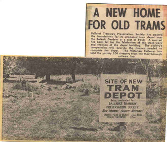
Newspaper, The Courier Ballarat, "A new home for old trams", 3/04/1972 12:00:00 AM
Yields information about the commencement of construction of the BTPS depot in the south Gardens reserve and seeking new members.Newspaper clipping from The Courier, Ballarat, dated Monday 3/4/1972, titled "A new home for old trams". Item reporting the BTPS had poured the foundations for its proposed tram depot near the Botanic Gardens, a contract had been let for the steel fabrication and that 200 sleepers had been obtained from the VR from the Maryborough line. Features a photo of the site with a sign advising the purpose of the works and seeking new members. One of large group of newspaper cuttings from John Bainbridge, 7/4/02. See Reg Item 3817 for a print of the actual photograph.depot, btps, depot construction -
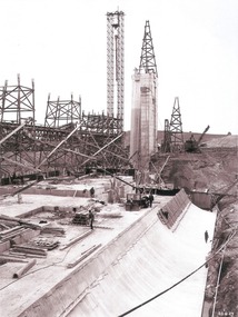
 Wodonga & District Historical Society Inc
Album - Hume Reservoir Australia Album - Excavations for foundations inside coffer dam, January 1927
This set of photos is from a leather bound album bearing the inscription "HUME RESERVOIR AUSTRALIA" plus 'The Rt. Hon. L. C. M. S. Amery, P. C., M .P.' all inscribed in gold. It was presented to The Rt. Hon. L. C. M. S. Amery, P. C., M. P, Secretary of State for Dominion Affairs on the occasion of his visit to the Hume Reservoir on 2nd November 1927. This album is of local and national significance as it documents the planning and development of the Hume Reservoir up to 1927. It was the largest water reservoir in the British Empire. The album records the pioneering engineering work that went into its construction.DEPARTMENT OF PUBLIC WORKS, N.S.W. RIVER MURRAY WATERS SCHEME. HUME RESERVOIR. 21. Excavations for foundations inside coffer dam. New South Wales. January 1927. Cofferdams are temporary structures used where construction is being carried out in areas submerged in water. They are most commonly used to facilitate the construction or repair of dams, piers and bridges. To divert the river, a Coffer Dam was built across the old bed above and below the Dam site and tying into the end of the concrete wall built inside the levee bank. This completely surrounded the remainder of the site of the Dam and south wing wall, including an area of 12½ acres. hume reservoir australia, river murray waters scheme, hume reservoir construction, coffer dam