Showing 182 items matching "historical geography"
-
 Bendigo Historical Society Inc.
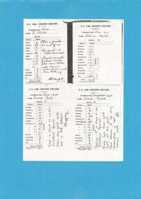
Document - GOLDEN SQUARE LAUREL STREET P.S. COLLECTION: EXAMINATION CARDS
Four white photocopy examination cards laminated upon blue cardboard and printed, SS 1189 , Golden Square, years 1941-42. Each outlines numbered marks out of ten for student named Elaine Rudd for subjects, Reading, Recitation, Spelling, Writing, Composition, English, Arithmetic A-B-C-D, History, Geography, Handwork, Art. B Rutherford and F Baggaley signatures. Written note states, 'Position; 3rd in class of 45. Excellent result. Elaine has done good work all the year. She seems to be very interested in her school work. Initialled FB.bendigo, institutions, golden square primary school -
 Bendigo Historical Society Inc.
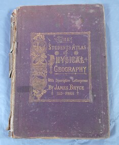
Book - Atlas of Physical Geography
The student's atlas of physical geography consisting of twenty maps, constructed and engraved by Edward Weller F.R.G.S. with descriptive letterpress by James Bryce L.L.D F.R.G.S. Published by William Collins, Sons & Company, London, Glasgow and Edinburgh 1871. Brown cover with the title of the book in gold letters. to the left of the title, also in gold, three circles with different pictures inside. the first of two boats on the sea, a volcanic eruption and a mountain peak.On first page in pencil the name Carrie Van Damme.geography, atlas, 1871 -
 Bendigo Historical Society Inc.
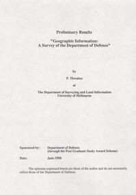
Document - FORTUNA COLLECTION: DOCUMENT
Document - titled : Preliminary Results 'Geographic Information: A Survey of the Department of Defence' Additional written information on title page reads: 'by P. Thwaites at The Deparment of Surveying and Land Information University of Melbourne. Sponsored by: Deparment of Defence (through the Post Graduate Study Award Scheme, Date: June 1988. ' Document is 17 single pages in length including a Contents page. -
 Kew Historical Society Inc
Album, Louisa G Thomas, Victorian Era Sketchbook, 1862
Louisa Thomas married Henry Gipps (1837-91)in 1863. They had six sons and two daughters. While Louisa and Henry Gipps were to die in Sussex, two of their sons, Frederick George De Visme Gipps (1867-1953) and Richard Brook Woodthorpe Gipps (c.1872-1946) migrated to Queensland, possibly bringing with them their mother’s sketchbook.The collection of artworks that are included in the sketchbook are often of outstanding aesthetic and artistic significance. In the variety of subject matter and the geographical places represented, it is historically significant as a document recording the postings of Colonel Henry Gipps, 9th Norfolk Regiment, and his wife Louisa to locations in the Mediterranean and West Asia. The large bound sketchbook has a marbled cover with blue binding. The name Louisa Goulburn Thomas and the date 1862 are faintly inscribed in pencil on the front page. However the book contains pen and ink and pencil drawings, watercolours, and photographs, which both predate and postdate 1862. The approximately 75 works are loose-leafed items and [currently] do not form a chronological, geographical or thematic sequence. Creators identified on some drawings and watercolours include Mary Julia Wilder Thomas, JFV Wright, ELG (Edward Louis de Bondell Gipps?), L Nicholson, Bertha Isadore Thomas, and HG (Henry Gipps?). Many of the works are signed and dated, and include rural landscapes and seascapes, archaeological sites, animal studies, and portraits. While most of the works were created in the British Isles, others are scenes of Venice, the Ionian Islands, Cape Town, Hong Kong and Japan. [A number of the ‘oriental’ paintings on silk were probably purchased from local artists.] The art works in the book are at various stages of completion and represent a diverse range of artistic skills. What may be the earliest work in the sketchbook is a drawing of three uniformed soldiers. An annotation on the reverse records that the drawing is of a Group of Soldiers after [Philipp Jakob] de Southerbourg 1830. The birth of Louisa Thomas' oldest son, William Henry Houston Meyrick Gipps (1864-1903) in Corfu perhaps explains why a number of scenes and items in the album are of the Ionian Islands. Louisa is probably the creator of a number of still life and botanical studies in the album. These range from floral studies to a bird’s nest. The painting of objects was to remain a socially ‘approved’ specialty of amateur and professional women artists into the 20th century. The complete contents of the album will be uploaded to accompany this record. Some items may be published separately on Victorian Collections, but will acknowledge their origins in the sketchbook."Louisa Goulburn Thomas / 1862"victorian sketchbooks, manuscripts - kew historical society, 9th norfolk regiment, rosemary (gipps) vaughan smith, vaughan-smith collection -
 Kew Historical Society Inc
Archive (Series) - Subject File, Kew Historical Society, Histories of Kew, 1958
Various partiesReference, Research, InformationSecondary Values (KHS Imposed Order)Subject file containing short general histories of Kew, or geographic parts thereof, and timelines compiled by various individuals, some of who were members of the Kew Historical Society. Authors of content include Isaac Selby, Dorothy Rogers, Dione McIntyre and Graeme Lindsay. Other authors are not identified. Some of these histories were used on annual bus trips of the suburb during the Kew Festival. Notes on specific aspects of Kew’s history relate to early exploration, settlement in Cotham Road, the influence of the environment, northern and eastern Kew and Studley Park. The majority of these monographs remain unpublished texts. The file also contains summaries and or transcripts of talks given to the Society by Geoff Clarke (1975) and Allan Wakefield about their recollections of Kew’s history.kew (vic) - history, kew - early landowners, kew - environmental history, geoff clarke, allan wakefield, kew historical society - members, kew historical society - researchkew (vic) - history, kew - early landowners, kew - environmental history, geoff clarke, allan wakefield, kew historical society - members, kew historical society - research -
 Kew Historical Society Inc
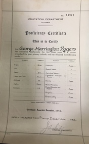
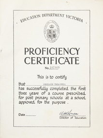
Certificate, Education Department (Victoria), Proficiency Certificate: George Harrington Rogers, 11/12/1942
This document was donated to the Kew Historical Society by John Rogers in 2015. Primary source for understanding the requirements of educational standards in Victoria in the 1940sEducation Department Victoria. Proficiency Certificate No.14942 This is to Certify that George Harrington Rogers has completed satisfactorily the first three years of a course prescribed for post primary school, and had obtained the following results. Pass - English, History and Civics, Algebra, Geography, Drawing, Physical Education and Hygiene, Physics, Chemistry. Certificate awarded 1942. Dated at Melbourne this 11th Day of December 1942. Signed Director of Education.certificates - education department victoria, proficiency certificates, george harrington rogers -
 Stawell Historical Society Inc
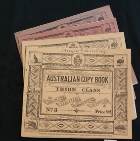
Booklet, Education Department, Australian Copy book
Books used in teaching writing0682-6: Fawn cardboard cover, with complex border artwork. 0682-7: Blue cardboard cover, with complex border artwork. 0682-8: Pink cardboard cover, with complex border artwork. 0682-6: S. Australia. Victoria. N.S. Wales. Queensland. Australian Copy Book Third Class. Medium Hand. Proverbs. Geographical Definitions. Arithmetic. No. 3 Price 2d. W. Australia Tasmania. New Zealand. Melbourne: Published for the Education Department by J. Kemp. Government Printer. 0682-7: Christina (Handwritten) S. Australia. Victoria. N.S. Wales. Queensland. Australian Copy Book Fourth Class. Small Hand. Proverbs. Geography. Commercial Terms. No.4 Price 2d. W. Australia Tasmania. New Zealand. Melbourne: Published for the Education Department by J. Kemp. Government Printer. 0682-8: Angus Cumming (Handwritten) S. Australia. Victoria. N.S. Wales. Queensland. Australian Copy Book Fifth and Sixth Class. Quotations, Poetry & Prose. Commercial. Letters & Forms. No.5 Price 2d. W. Australia Tasmania. New Zealand. Melbourne: Published for the Education Department by J. Kemp. Government Printer.stawell education -
 Stawell Historical Society Inc
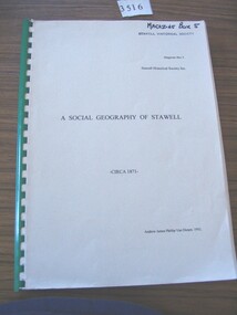
Book, Andrew James Phillip Van Diesen, Social Geography of Stawell Circa 1871, 1992
A Paper for a Graduate Diploma in Regional Studies (History) by Andrew James Phillip Van Diesen.Grey Paper Cover with Green Plastic spine, Black Print for title and AuthorA Social Geography of Stawell. - Circa 1871- Andrew James Phillip Van Diesen. 1992stawell -
 Surrey Hills Historical Society Collection
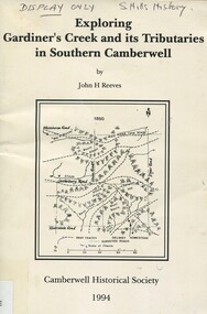
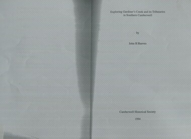
Book, Exploring Gardiner's Creek and its tributaries in southern Camberwell, 1994
This book describes geographical landmarks, in particular the waterways, that make up the City of Camberwell (now City of Boroondara).This book describes geographical landmarks, in particular the waterways, that make up the City of Camberwell (now City of Boroondara).gardiner's creek, (mr) john gardiner, koonung creek, back creek, glass's creek, w creek, west creek, ashburton creek, delaney's creek, walking trails, rivers, creeks, glass creek -
 Surrey Hills Historical Society Collection
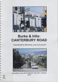
Book, Burke & hills: Canterbury Road, Camberwell to Montrose, past and present, 2014
Co-author Gerry Robinson was a speaker at a Surrey Hills Historical Society (SHHS) meeting. Lyndel Walker, member of SHHS, purchased the book for the collection. This book examines the changing landscape of Canterbury Road from the early days of settlement until today (2015)This book examines the changing landscape of Canterbury Road from the early days of settlement until today (2015)burke, surrey hills, canterbury, broughton park, vegetation, (mr) denis delaney, geology, (mr) john mcclare, geography, (mrs) mary mcclare, churches -
 Surrey Hills Historical Society Collection
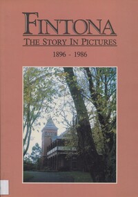
Book, Fintona - the story in pictures, 1896-1986, 1986
Compiled by Phyllis Reichl (b1915). She was awarded an Honorary Life Membership of the Geography Teachers' Association of Victoria. She died in 2005.Soft cover book of 110 pages with annotated photos. There is a 4 page overview of the school's history and an appendix with identification of individuals in group photos.Inside the front cover: "For the Surrey Hills Historical Society / from Fintona Girls' School / 19.10.98 Alison Adams, Archivist"schools, education, fintona, independent schools, (ms) alison adams, (ms) phyllis reichl -
 Surrey Hills Historical Society Collection
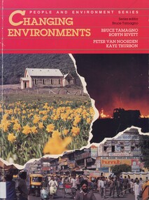
Book, Changing environments, 1990
There is a chapter dedicated to the physical and built environment of Surrey Hills and surrounding area. It includes maps drawn from the work of Alan Holt. The late Robyn Rivett (Rhodes) taught geography before becoming a curriculum adviser within the Education Department. She lived in Surrey Hills.Surrey Hills Neighbourhood Centre - historyhuman ecology, anthropo - geography, (mr) bruce tamango, people and environment series, streetscapes, (mrs) robyn rivett, (mrs) robyn rhodes, (mr) alan holt, surrey hills -
 Surrey Hills Historical Society Collection
Book, Exploring Gardiner's Creek and its tributaries in southern Camberwell, 1994
This book describes geographical landmarks and especially waterways that of the City of Camberwell (now City of Boroondara).This book describes geographical landmarks and especially waterways that of the City of Camberwell (now City of Boroondara).gardiner's creek, (mr) john gardiner, koonung creek, back creek, glass's creek, w creek, west creek, ashburton creek, delaney's creek, walking trails, rivers -
 Port Fairy Historical Society Museum and Archives
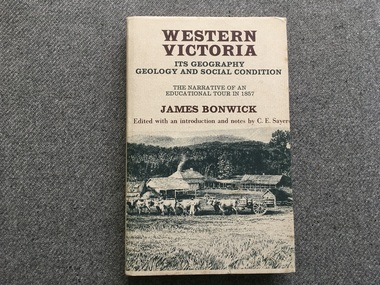
Book, James Bonwick, Western Victoria It’s geography geology and social condition. The Narrative of an Educational Tour in 1857
1857 tour of Western Victoria including Tower Hill, Belfast and Yambuk.non-fiction1857 tour of Western Victoria including Tower Hill, Belfast and Yambuk.colonial education, belfast, victoria 1857, book -
 Kilmore Historical Society
CLASS-BOOK OF GEOGRAPHY, 1888
School binding of brown paper stitched across from cover 323 pages ; 16cm ; N/Aschool text, geography -
 Kilmore Historical Society
STEWART'S GEOGRAPHICAL LIBRARY AUSTRALASIA, Popular Geographical Library, 1853
Faded brown cloth cover with embossing detailing on covers and gold embossing on spine 'Stewart's Geographical Library Australasia' 480 pages ; 18cmHand written inscription on first page Stamp on various pages ' Kilmore Mechanics Institute' geography, australiasia, kilmore mechanics institute library. -
 Kilmore Historical Society
CHAMBERS INFORMATION FOR THE PEOPLE VOL 2, 1848
Faded brown loose cloth cover with embossed detailing on cover and spine 'Chambers information for the people, Vol 2, History - Geography' 809 pages ; Maps; Illus; Handwritten inscription on first page - '37, 41, 040 CHA R 29' Stamp on various pages 'Kilmore Mechanics Institute' encyclopedia, kilmore mechanics institute library. -
 Kilmore Historical Society
PHYSICAL GEOGRAPHY OF AUSTRALIA, Manual of Physical Geography of Australia, 1873
Green leather cover with gold writing on spine 'Physical Geography of Australia' 167 pages ; 17 cm ; Illu ; indexHandwritten inscription on first page '137' Stamp on multiple pages 'Kilmore Mechanics Institute'geography, kilmore mechanics institute library. -
 Bacchus Marsh & District Historical Society
Map, Bacchus Marsh Township and Nearby Districts Maps Volume
This volume of maps is believed to have been compiled by staff at the Shire of Bacchus Marsh and was presumably used to inform and assist Shire staff and Councillors in the carriage of their duties.This collection of maps are significant due to their rarity as many of them are unique maps made for local purposes in the Bacchus Marsh region. They are also of strong research value containing a wide variety of information including landholders, land sales, infrastructure, such as roads, bridges, public, commercial and private buildings, houses, land use, and geographic features over multiple decades from the late nineteen century into the middle part of the twentieth century.One bound volume of maps comprising cadastral maps, (indicating property owners and land boundaries), land plans and real estate auction plans and advertising material, and other maps indicating major infrastructure like proposed roads and irrigation areas. Most of the maps and plans are of Bacchus Marsh and nearby areas but some maps are of nearby towns such as Melton, Ballan and Blackwood. The volume comprises 52 pages. Most pages have a single map or plan pasted onto it but some contain 2 or 3 different maps. There are 81 maps in total. Map 1 Liquidators Sale 1896. Map 2. Woodside Estate Sale 1913. maps, maps bacchus marsh, maps bacchus marsh region -
 Bacchus Marsh & District Historical Society
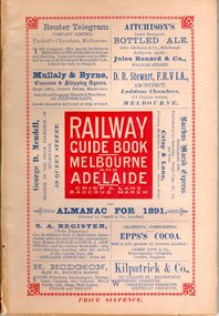
Book, Railway guide book and time table for Melbourne, Ballarat, Adelaide and all intermediate stations, also gazette for Bacchus Marsh, Ballan, Melton, &c., and almanac for 1891
... , Ballan and Melton, pp.27-30; historical, geographic, and economic ...Publication details: 'Railway guide book and time table for Melbourne, Ballarat, Adelaide and all intermediate stations, also gazette for Bacchus Marsh, Ballan, Melton, &c., and almanac for 1891', compiled by Christopher Crisp. Printed and published by Crisp and Lane, Bacchus Marsh, Vic., 1891. SUMMARY OF CONTENT: Includes detailed timetables and schedule of fares, descriptions of stations and refreshment facilities pp.6-26; overviews of Shires of Bacchus Marsh, Ballan and Melton, pp.27-30; historical, geographic, and economic background notes about places on the Melbourne to Adelaide route, pages 31-64, including descriptions of Bacchus Marsh, pp.34-42 and briefer notes on Ballan, pp.42-43 and Melton, pp.32-33. Almanac section is pp.65-95 (not numbered), containing common information in nineteenth century almanacs such as a calendar of the days, weeks, and months of the year; a record of various astronomical phenomena, climate information and seasonal suggestions for farmers, the rising and setting times of the Sun and Moon, dates of eclipses, hours of high and low tides, and religious festivals. A brief history of Irrigation in Mildura is on pages 1 and 112 (first and last pages). Advertisements, mostly for Bacchus Marsh businesses are on pp.96-111. The Almanac section is illustrated with drawings of scenic views of various places in Australia, but none of the Bacchus Marsh region. Online access is available on Trove at: http://nla.gov.au/nla.obj-392504046Printed book. 112 pages in total. Pages 13 -64 numbered.non-fictionPublication details: 'Railway guide book and time table for Melbourne, Ballarat, Adelaide and all intermediate stations, also gazette for Bacchus Marsh, Ballan, Melton, &c., and almanac for 1891', compiled by Christopher Crisp. Printed and published by Crisp and Lane, Bacchus Marsh, Vic., 1891. SUMMARY OF CONTENT: Includes detailed timetables and schedule of fares, descriptions of stations and refreshment facilities pp.6-26; overviews of Shires of Bacchus Marsh, Ballan and Melton, pp.27-30; historical, geographic, and economic background notes about places on the Melbourne to Adelaide route, pages 31-64, including descriptions of Bacchus Marsh, pp.34-42 and briefer notes on Ballan, pp.42-43 and Melton, pp.32-33. Almanac section is pp.65-95 (not numbered), containing common information in nineteenth century almanacs such as a calendar of the days, weeks, and months of the year; a record of various astronomical phenomena, climate information and seasonal suggestions for farmers, the rising and setting times of the Sun and Moon, dates of eclipses, hours of high and low tides, and religious festivals. A brief history of Irrigation in Mildura is on pages 1 and 112 (first and last pages). Advertisements, mostly for Bacchus Marsh businesses are on pp.96-111. The Almanac section is illustrated with drawings of scenic views of various places in Australia, but none of the Bacchus Marsh region. Online access is available on Trove at: http://nla.gov.au/nla.obj-392504046railways, railway lines, almanacs, railway lines timetables -
 Kilmore Historical Society
Book, Baron Ferdinand von Mueller, SYSTEMATIC CENSUS OF AUSTRALIAN PLANTS. Part 1. - Vasculares, 1882
Systematic Census of Australian Plants with Chronologic, Literary and Geographic Annotations.Paper cover, stained, foxing, insect damage to extremities. Cloth strip to spine, tearing at top and bottom. 152 pp. Binding generally intact, pp 51-54 detached. Sewn binding shows metallic/rust staining. Pages generally clean & unmarked throughout. Fair condition.non-fictionSystematic Census of Australian Plants with Chronologic, Literary and Geographic Annotations.botany, australia -
 Kilmore Historical Society
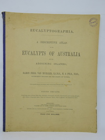
Book, Baron Ferdinand von Mueller et al, EUCALYPTOGRAPHIA. Tenth Decade, 1884
A descriptive atlas of the Eucalypts of Australia and adjoining islands. This last part of the series also contains a Synopsis of the Species, Geographic Index, Index of Vernacular Names, Index of Decades and Alphabetical Index.Light card cover with blue cloth backstrip to spine, torn at upper extremity. Some staining and marks on cover, discoloration from light exposure. Some foxing through out. Binding intact. Fair condition.non-fictionA descriptive atlas of the Eucalypts of Australia and adjoining islands. This last part of the series also contains a Synopsis of the Species, Geographic Index, Index of Vernacular Names, Index of Decades and Alphabetical Index.botany, eucalypts, australia -
 Kilmore Historical Society
Book, WHITCOMBE'S FEDERAL GEOGRAPHY, c1920
School text, Grade 8 geographyGrey cover, stained & torn, brown paper cover, pages torn & ink-marked. 160pp. Fair conditionnon-fictionSchool text, Grade 8 geographychildren, textbook, glanville, geography -
 Wodonga & District Historical Society Inc
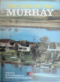
Book - The Book of the Murray, Lawrence, G. V.; and Smith, Graeme Kinross, 1975
... Wodonga & District Historical Society Inc Hut 97, Bonegilla ...This book contains contributions from 16 writers who have first-hand knowledge of the Murray River area. It provides a comprehensive picture of the river in all its aspects. It gives a fascinating look at one of Australia's most important geographical and historical features. Contributors and chapters in this book are: - 1. Past, Present and Future – G. V. Lawrence 2. The Structure of the Murray – Edmund D. Gill 3. Seeing the Murray – Graeme Kinross Smith 4. The Mountains at the Source – Elyne Mitchell 5. The Explorers – Leigh Betheras 6. The Irrigators – G. Arch Grosvenor 7. Murray Water Conservation – W. G. L. Harrison & K. E. Johnson 8. The Murray River Steamers – Ian Mudie 9. Pioneer Days: A Story of Seventy Years Ago – Dorothy Roysland 10. Birdlife of the Murray Valley – John Eckert 11 .Aborigines in the Murray Valley, How We Learned the Story – H. A. Lindsay, The Aboriginal Occupation – Norman B. Tindale 12. Fish of the Murray River – John S. Lake 13. Native Plants of the Murray Valley – J. H. Willis 14. Murray Wildlife – K. N. G. SimpsonThis publication has a hard cover with blue boards and a pictorial dust jacket. It consists of 264 pages.This book contains contributions from 16 writers who have first-hand knowledge of the Murray River area. It provides a comprehensive picture of the river in all its aspects. It gives a fascinating look at one of Australia's most important geographical and historical features. Contributors and chapters in this book are: - 1. Past, Present and Future – G. V. Lawrence 2. The Structure of the Murray – Edmund D. Gill 3. Seeing the Murray – Graeme Kinross Smith 4. The Mountains at the Source – Elyne Mitchell 5. The Explorers – Leigh Betheras 6. The Irrigators – G. Arch Grosvenor 7. Murray Water Conservation – W. G. L. Harrison & K. E. Johnson 8. The Murray River Steamers – Ian Mudie 9. Pioneer Days: A Story of Seventy Years Ago – Dorothy Roysland 10. Birdlife of the Murray Valley – John Eckert 11 .Aborigines in the Murray Valley, How We Learned the Story – H. A. Lindsay, The Aboriginal Occupation – Norman B. Tindale 12. Fish of the Murray River – John S. Lake 13. Native Plants of the Murray Valley – J. H. Willis 14. Murray Wildlife – K. N. G. Simpsonmurray river, australian geography, settlement on the murray river, native plants, aborigines in the murray valley, murray valley flora and fauna -
 Wodonga & District Historical Society Inc
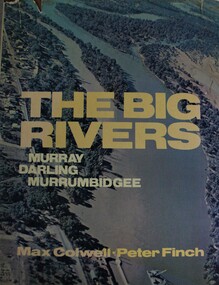
Book - The Big Rivers: Murray Darling Murrumbidgee, Max Colwell, 1978
A geography, description and travel guide to the "Big Rivers" of the Murray- Darling basin, including many photos of the region.non-fictionA geography, description and travel guide to the "Big Rivers" of the Murray- Darling basin, including many photos of the region.murray river (n.s.w.-s.a.), murray river valley, darling river, murrumbidgee river, description and travel nsw, description and travel south australia -
 Wodonga & District Historical Society Inc
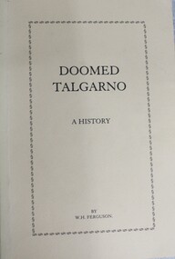
Book - Doomed Talgarno - A History, W. H. Ferguson, C. 1920 - 1929
A detailed study of the township of Talgarno in North Eastern Victoria, its geography and pioneering families. In the mid-1930s Talgarno’s river flats were inundated by the development of Lake Hume.non-fictionA detailed study of the township of Talgarno in North Eastern Victoria, its geography and pioneering families. In the mid-1930s Talgarno’s river flats were inundated by the development of Lake Hume.talgarno, pioneers north east victoria, lake hume -
 Merbein District Historical Society
Certificate - Proficiency Certificate
Proficiency certificate A4 certificate No 107909Front education department Victoria logo in oval with coat of arms and crown Proficiency certificate NO 107909 This is to certify that Penelope Treadwell has successfully completed the first three years of a course prescribed for post primary schools at a school approved for the purpose director of education Back the candidate has completed a course of study in the following subjects with results as indicated English pass, algebra pass, geometry pass, geography pass, general science pass agricultural science, French credit pass , German, Latin, history pass, social studies , musical appreciation, art credit pass, shorthand, home management including cookery, needle work credit pass, crafts, woodwork, metalwork, blacksmithing, mechanical drawing, physical education pass. education, penelope treadwell, proficiency certificate -
 Warrnambool and District Historical Society Inc.
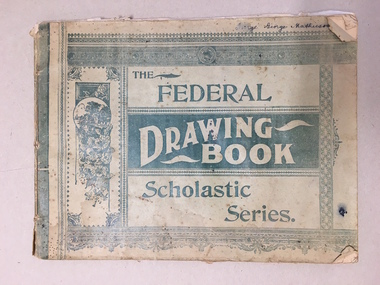
Booklet, The Federal Drawing Book Scholastic Series, C 1930
This school book which was owned by George Mathieson contains maps and information on different countries around the world. It is handwritten and is probably of secondary school level. The maps appear to have been traced and hand-drawn and coloured. There is a loose newspaper map of the Dardenelles loose in the book. This book as an example of school work and geography in the early 20th century, has social and historical significance.Pale green light card cover with dark green pattern and text. Back cover is plain. It contains alternate pages of tracing paper in between normal pages. Bound with cotton? threadGeorge mathieson, written in ink on front cover.federal drawing book, george mathieson, school drawing book 1920's, warrnambool -
 Warrnambool and District Historical Society Inc.
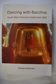
Book, Pam Marriott (publisher), Dancing With Bacchus, 2021
This book contains information on South West Victorian hotels from 1839This is a soft cover book of 348 pages. The cover has a white background with gold-coloured print, a red and orange image of dancers on the front cover and a photograph of liquor bottles and grapes on the back cover. The book contains a foreword, an index, printed text and black and white photographs.non-fictionThis book contains information on South West Victorian hotels from 1839 hotels in south west victoria, warrnambool history -
 Bendigo Historical Society Inc.
Document - VICTORIA HILL - THE RICH VICTORIA HILL AND ITS HISTORICAL ASSOCIATIONS
Copy and a photocopy of notes titled 'The rich Victoria Hill and its Historical Associations. The photocopy does not have copies of the photos. Notes include Introduction, directions for getting to Victoria Hill, North Old Chum Mine 2310 ft deep, Ballerstedt's First Open Cut, Geographical Features, Lansell's Big 180, Crushing Battery, Lansell's Cleopatra Needle type chimney, Victoria Quartz Mine 4613 ft deep, Victoria Reef Quartz Company, Victoria Quartz Company, Victoria Quartz Dams, Rae's Open Cut, Quartz Roasting, Floyd's small 5 Head Crushing Battery, Great Central Victoria (Midway) Shaft, Ballerstedt's Small 24 yard Claim, The Humboldt, The Adventure, The Advance and Luffsman and Sterry's Claim. Copies of photos include: Victoria Hill from Rae's Open Cut, Looking North from Old Chum Hill to the Victoria Hill, the Victoria Quartz Mine and Wm. Rae's Crushing Works.document, gold, victoria hill, the rich victoria hill and its historical associations, j n macartney, quartz miners' arms hotel, ironbark methodist church, john brown knitwear factory, little 180, george lansell, conrad heinz, british and american hotel, victoria reef gold mining company, manchester arms hotel, housing commission homes, the ironbark, hercules and energetic, midway, wittscheibe, great central victoria, wm rae, mr & mrs conroy, moorhead's shop, central nell gwynne, gold mines hotel, david chaplin sterry, new chum & victoria, old chum, burrowes & sterry, rotary club of bendigo south, big 180, north old chum mine, ballerstedt's first open-cut, lansell's bit 180 shaft, victoria quartz mine, victoria reef quartz company, a roberts & sons, mr e j dunn, h harkness & sons, new chum drainage scheme, eureka extended, new chum railway, the pearl, inrush of water, shamrock, shenandoah, victoria quartz dams, rae's open cut, floyd's small 5 head crushing battery, great central victoria (midway) shaft, midway no 2, midway north, the humboldt, the adventure, the advance, luffsman & sterry's claim, chinese joss house, fortuna, p m g repeater station, bendigo and vicinity 1895, j n macartney 1st edition 1871, mr rae anderson, 'gill family, annals of bendigo obituary notices 1904, mining records and australian mining standard special edition 1/6/1899, bendigo advertiser 22/6/1871, b m l records mines department, patterson's goldfields of victoria, dickers mining record 23/11/1861, annals of bendigo, bendigo advertiser 24/7/1933, 27/8/1908, 30/6/1910, 16/6/1910, 17/6/1910, mining reports for 1910, australian mining standard special edition 1/6/1899 p40, bendigo mines ltd, mines department records, the bendigo goldfield 1851 to 1954, the victoria hill 1854 to 1949, wm rae's crushing works