Showing 11639 items matching "island"
-
 Phillip Island and District Historical Society Inc.
Book, CUTTER, June M, Churchill Island : a special place : a story of those who chose Churchill Island as their haven, 1994
Stamped 'Phillip Island & District Historical Society'. Proceeds of this book are donated to the Friends of Churchill Island Society.pioneers, victoria, churchill island, history, fiction -
 Phillip Island and District Historical Society Inc.
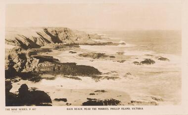
Sepia Photograph, 1920
This ablum was presented to the Earl of Stradbroke by the Fathers of Soldiers and Returned Soldiers 16/2/1923. The photo is of the Back Beach near The Nobbies, Phillip Island.Postcard showing the Back Beach near The Nobbies, Phillip Island, VictoriaRose Series P667 Back Beach, near The Nobbies, Phillip Island, Victoriaphillip island, back beach, earl of stradbroke, the nobbies -
 Phillip Island and District Historical Society Inc.
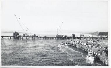
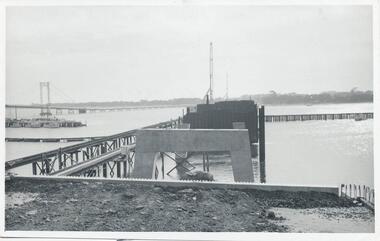
Photographs, Country Roads Board, Construction of 2nd Phillip Island Bridge 1966 - 1969, 1966 - 1969
Collection of Black & White photographs of the construction of the second Phillip Island Bridge by the Country Roads Board. Contractor John Holland & Co Pty. Ltd.Black & White photographs of the Construction of the Phillip Island 2nd Bridge in 1969 351-01: View from centre of suspension bridge. 351-02: Concreting Pier 8 351-03: Concreting Pier 8 351-04,05 & 06: Metal beams. 351-07: Driving sheet Piling. 351-08:Reinforcement in caisson (watertight structure)351-01: Country Roads Board Victoria, Aust. Negative No. 67-37 - Phillip Island Bridge Project. Shire of Bass 352-02: As above - Negative No. 67-38B 352-03: As above - Negative No. 57-38D. 352-04: Negative No. 67-223A. 352-05: Negative No. 67-223B 352-06: Negative No. 67-223D 352-07: As 352-01-03 plus Negative No. 67-312 352-08: As above - Negative No. 67-272.phillip island bridge (1969), country roads board, sasha stark -
 Phillip Island and District Historical Society Inc.
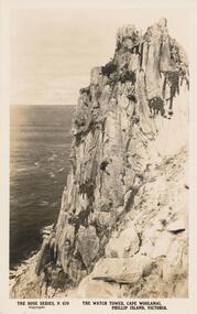
Sepia Photograph, 1920's
This album was presented to the Earl of Stradbroke by Fathers of Soldiers and Returned Soldiers 16/02/1923. Photo showing cliffs called The Watch Tower, Cape Woolamai, Phillip Island.Cliff known as "The Watch Tower", Cape Woolamai, Phillip Island, VictoriaRose Series P679. The Watch Tower, Cape Woolamai, Phillip Island, Victoriaphillip island, cape woolamai, earl of stradbroke, the watch tower cliffs -
 Lakes Entrance Historical Society
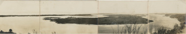
Postcard, Reeves Channel, Rigby Island, the entrance, Bullock Island , Lakes Entrance Victoria, 1920 c
Views of Gippsland Lakes from Jemmy's Point Lakes EntranceBlack and white panoramic folding postcard of the Gippsland Lakes including Reeves Channel, Rigby Island, the entrance, Bullock Island and Lakes Entrance township taken from Jemmys Point Lakes Entrance Victoria. Also panoramic postcard view from southern part of Rigby Island to Lakes Entrance township. And a third postcard "KALIMNA COVE LAKES ENTRANCE"waterways, gippsland lakes -
Phillip Island and District Historical Society Inc.
Photograph
Phillip Island suspension Bridge built 1938/1940 - demolished 1970. Part of an album compiled and donated by Mrs Helen Jansson.Print of Phillip Island Suspension Bridge. Aerial view showing Jetties at left with sweep of sandy beaches middle to top left.No. 1. Phillip Island Bridge, Victoria. Airapy Photolocal history, photography, photographs, slides, film, civil engineering, bridges, jetties, phillip island suspension bridge, black & white photograph, mrs. helen jansson, suspension bridges, phillip island -
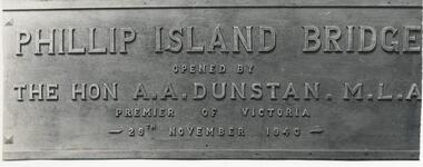 Phillip Island and District Historical Society Inc.
Photograph, 29/11/1940
One of a collection of over 400 photographs in an album commenced in 1960 and presented to the Phillip Island & Westernport Historical Society by the Shire of Phillip IslandPhotograph of the Bronze Plaque on the first Phillip Island Bridge showing wording clearly. 29/11/1940Phillip Island Bridge opened by The Hon A. A. Dunstan M. L. A. Premier of Victoria 29th November 1940.local history, photography, photographs, bronze plaque on first phillip island bridge, black & white photograph, phillip island bridge, the hon. a. a. dunstan. mla, john jenner, bryant west -
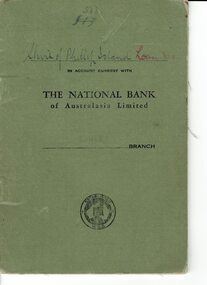 Phillip Island and District Historical Society Inc.
Book, Bank book Shire of Phillip Island Loan No. 9, 1941
Loan of 750 pound from the National Bank to the Shire of Phillip Island. 1941-1952HistoricalSmall soft covered, green coloured bank book containing handwritten entries for debits and credits and balances.533 Shire of Phillip Island Loan in account current with The National Bank of Australasia Limited Cowes Branchshire of phillip island, national bank cowes, banking -
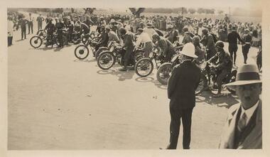 Phillip Island and District Historical Society Inc.
Photographs, Early 20th Century
A collection of six photographs donated by John Jansson. The first Grand Prix motorbike and car races were held on a course around the roads of Phillip Island.Six black & white photographs taken on Phillip Island. 365-01: Waiting for start of 100 mile event on Phillip Island for Motor Cycle Race. 365-02: Lined up for start of the 50 mile Grand Prix Race on Phillip Island. 365-03: Start of the 50 mile event. 365-04: Approaching Cowes Pier, Phillip Island. 365-05: The Nobbies, Phillip Island. 365-06: View near The Nobbies with waves breaking over the rocks.365-01: ACUV Races P.I. Waiting for start of 100 mile 365-02: Grand Prix Races. Lined up for start of 50 mile. 365-03: Start of 50 mile event. 365-04: Approaching Cowes 365-05: The Nobbies Phillip Island. 365-06: View near The Nobbies Phillip Island.motorbike racing on phillip island, the nobbies phillip island, cowes pier phillip island, john jansson -
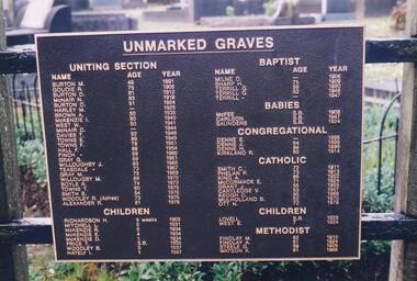 Phillip Island and District Historical Society Inc.
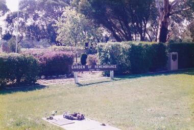
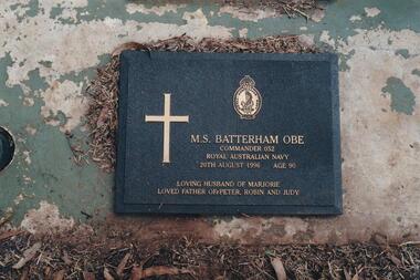
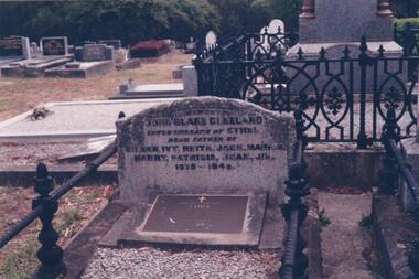
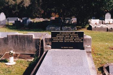
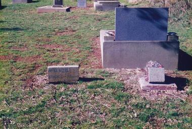
Photograph Album, Kodak, Phillip Island Cemetery, c 1990
The Album was compiled by Nancy McHaffie late 1990's, with the assistance of Edith Jeffery's, with her book "Garden of Memories" and extensive knowledge of Phillip Island. The Cemetery lies back from the road and is surrounded by Manna Gums, rare Peppermint Gums, Blackwoods and other native trees. In all 25 acres of land were set aside as Crown Land in the land settlement of 1868. There are 6.2 acres of wetlands near the cemetery entrance.2 Photographs: 466-08 Notice of the Unmarked Graves. Although the land for the cemetery was granted in 1870, a survey was not made until 1903 hence the existence of unmarked graves. 466-09 A disastrous fire swept through the cemetery in 1943, destroying many structures around the graves - hence the rule "no wooden structures". the Hitching Posts were used for tying up hrses during a funeral service. They were erected in 1912 and now only two remain.phillip island cemetery, nancy mchaffie, edith jeffrey -
 Phillip Island and District Historical Society Inc.
Photograph Album, Kodak, Phillip Island Cemetery, c 1990
The Album was compiled by Nancy McHaffie late 1990's, with the assistance of Edith Jeffery's, with her book "Garden of Memories" and extensive knowledge of Phillip Island. The Cemetery lies back from the road and is surrounded by Manna Gums, rare Peppermint Gums, Blackwoods and other native trees. In all 25 acres of land were set aside as Crown Land in the land settlement of 1868. There are 6.2 acres of wetlands near the cemetery entrance.5 Photographs of the Garden of Remembrance. 466-10 - Garden of Remembrance sign 466-11 - On the 8th November 1990, two Life Members of the League, Mr Eddie Patton and Mr Ken Lang, planted a young seedling from the original Lone Pine from Gallipoli in the Memorial Garden 466-12 - The Returned Servicemens League placed a Flagpole and Granite Stone in the Memorial Garden in memory of the fallen 466-13 & 14 - Garden of Remembrance Plaquesphillip island cemetery, nancy mchaffie, edith jeffrey -
 Phillip Island and District Historical Society Inc.
Photograph Album, Kodak, Phillip Island Cemetery, c 1990
The Album was compiled by Nancy McHaffie late 1990's, with the assistance of Edith Jeffery's, with her book "Garden of Memories" and extensive knowledge of Phillip Island. The Cemetery lies back from the road and is surrounded by Manna Gums, rare Peppermint Gums, Blackwoods and other native trees. In all 25 acres of land were set aside as Crown Land in the land settlement of 1868. There are 6.2 acres of wetlands near the cemetery entrance.Lt. Commander M Batterham OBE RANVR was born in 1906 and later attended Geelong Grammar School. First attempt to join RAN was unsuccessful, due to health reasons. In 1942 he joined the Naval Volunteer Reserve. This was the beginning of a naval career which extended to peace-time in Canberra. He was awarded the OBE in 1952 for courage and devotion to duty. Maurice was laid to rest in the lawn section of the cenetery, August 1996 aged 90 years old.phillip island cemetery, nancy mchaffie, edith jeffrey -
 Phillip Island and District Historical Society Inc.
Photograph Album, Kodak, Phillip Island Cemetery, c 1990
The Album was compiled by Nancy McHaffie late 1990's, with the assistance of Edith Jeffery's, with her book "Garden of Memories" and extensive knowledge of Phillip Island. The Cemetery lies back from the road and is surrounded by Manna Gums, rare Peppermint Gums, Blackwoods and other native trees. In all 25 acres of land were set aside as Crown Land in the land settlement of 1868. There are 6.2 acres of wetlands near the cemetery entrance.466-29: John Blake Cleeland lived in the house his father built, "Woolamai House" in Newhaven. His property ran cattle, horses and angora goats. He had a great love of the sea although he never went to sea. He logged all shipping movements around the Eastern passage of Westernport. He was Captain-in-charge of the Rocket Apparatus Station at Newhaven, which was a rescue service for shipping. 466-30: Eleanor Blake (nee Lucas) came out from Ireland in 1860 together with her husband Edward Hudson Blake and children. For most of her life in Australia, she resided at Hastings. Her youngest daughter Isabella married John Cleeland, both of whom are buried in the cemetery. Eleanor moved from Hastings to "Woolamai House" in later years. 466-31: Margaret Jane Cleeland (nee Kennon) married John Blake Cleeland on May 21st 1903 at South Yarra. She was the daughter of Stanley Stowell Kennon, a farmer and her mother was Isabella (nee Turner). Margaret died in 1909 at the age of 30 years. At the time of her death she was survived by three children: Eileen Henrietta, Ivy Florence & Reita Vermont.phillip island cemetery, nancy mchaffie, edith jeffery, cleeland -
 Phillip Island and District Historical Society Inc.
Photograph Album, Kodak, Phillip Island Cemetery, c 1990
The Album was compiled by Nancy McHaffie late 1990's, with the assistance of Edith Jeffery's, with her book "Garden of Memories" and extensive knowledge of Phillip Island. The Cemetery lies back from the road and is surrounded by Manna Gums, rare Peppermint Gums, Blackwoods and other native trees. In all 25 acres of land were set aside as Crown Land in the land settlement of 1868. There are 6.2 acres of wetlands near the cemetery entrance.Stanley Joseph McFee; Stanley was born at Auburn Grove, Auburn on the 23rd January 1892. He was the seventh son of William and Annie McFee. The McFee family moved to Rhyll in 1894 where Stanley was educated at the Rhyll School. Later he took up farming at Long Point, now known as McFees Road. In 1917 Stanley married Isabell May Cherry who came to Rhyll in 1912 as the school teacher. His wife May supported him in his community activities. Stanley died 1980 aged 88. Isabell May died 1966 aged 78. phillip island cemetery, stanley mcfee, isabell mcfee, nancy mchaffie, edith jeffery -
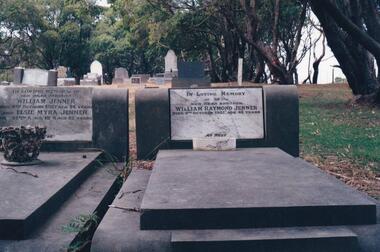 Phillip Island and District Historical Society Inc.
Photograph Album, Kodak, Phillip Island Cemetery, c 1990
The Album was compiled by Nancy McHaffie late 1990's, with the assistance of Edith Jeffery's, with her book "Garden of Memories" and extensive knowledge of Phillip Island. The Cemetery lies back from the road and is surrounded by Manna Gums, rare Peppermint Gums, Blackwoods and other native trees. In all 25 acres of land were set aside as Crown Land in the land settlement of 1868. There are 6.2 acres of wetlands near the cemetery entrance.Two photos: a) Two graves - William Jenner & Elsie Myra Jenner. William died Oct 1957 aged 73 and Elsie died April 1968 aged 82. - William Raymond Jenner - son of William & Elsie - died Oct 1951 aged 42 years. b) Close up of William & Elsie grave. William had a farm at Ventnor, grew onions and chicory and was always willing to help out or lend any farming machinery. William was a member of the Ventnor School committee and Ventnor Hall committee. He was married to Elsie Churchill of Kilcunda and they had five children.phillip island cemetery, william jenner, elsie jenner, nancy mchaffie, edith jeffery -
 Phillip Island and District Historical Society Inc.
Photograph Album, Kodak, Phillip Island Cemetery, c 1990
The Album was compiled by Nancy McHaffie late 1990's, with the assistance of Edith Jeffery's, with her book "Garden of Memories" and extensive knowledge of Phillip Island. The Cemetery lies back from the road and is surrounded by Manna Gums, rare Peppermint Gums, Blackwoods and other native trees. In all 25 acres of land were set aside as Crown Land in the land settlement of 1868. There are 6.2 acres of wetlands near the cemetery entrance.The McKenzie Children: Late one night in 1934, Mr Bryant West and Mr Loton heard cries for help from the vicinity of the Cowes Jetty. Attempts were made to save a woman and the children. Sadly only the adult could be rescued. The three young bodies were later recovered and buried in the cemetery. Parents: Ronald & Ena McKenzie - Children: Ronald aged 5 years, Ena Roma aged 4 years and Douglas Forbes aged 1 year. phillip island cemetery, the mckenzie children, nancy mchaffie, edith jeffery -
 Phillip Island and District Historical Society Inc.
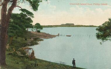
Photograph - Post Card, Early 1900's
Donated by A. WilkieColoured postcard. Man standing at water's edge looking across from Phillip Island to Churchill Island. Trees on left hand side. A wattle shelter in foreground. A couple of figures and a dog near moored boat a remains of a Jetty."Churchill Island from Phillip Island"churchill island, phillip island, jetty, a. wilkie -
 Phillip Island and District Historical Society Inc.
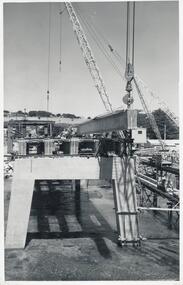
Photographs, Country Roads Board, Phillip Island 2nd Bridge Construction, 1966 - 1969
Eight of a collection of 70 photographs taken at the time of the Phillip Island second bridge construction by Country Roads Board & Shire of Bass. Contractor John Holland & Co Pty LtdEight Black & White photographs of the construction of the 2nd Phillip Island Bridge from San Remo to Newhaven - built from 1966 to 1969. Photographs showing various aspects of the construction.351-43: CRB NEG No. 67-1930E. Placing 1st Beam on Span 3. 351-44: CRB NEG No. 67-1930F. 1st Beam on Span 3. 351-45: CRB NEG No. 68-2126H. 351-46: CRB NEG No. 68-2126B. 351-47A: CRB NEG No. 67-2708A. 351-47B: CRB NEG No. 67-2708C. 351-48: CRB NEG No. 67-2708D. 351-49: CRB NEG No. 66-2860Aphillip island 2nd bridge construction, phillip island bridge, country roads board, shire of bass, john holland & co pty ltd, sasha stark -
 Phillip Island and District Historical Society Inc.
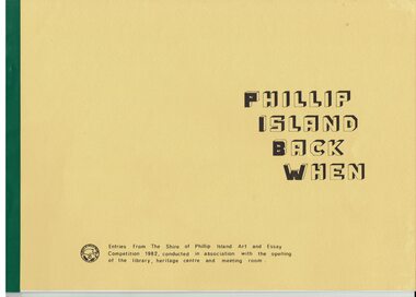
Booklet, Phillip Island Back when 1982 Art and Essay Competition, 1984
The competition was to increase awareness of the pioneering of Phillip Island. 155 entries were received and winners were compiled in the booklet. Art competition winners were Open- Frances Reith and Maree Chaston. Secondary- Neil McRae and Shannon Condick. Primary- Laurie Chisholm and Paul Matthews. Essay Competition winners were Open- Patsy Hunt and Audrey Nicol.. Secondary- Judy Nicol and Cameron Ashe. Primary- Joanne Scrase and Richard Patching.HistoricalLarge yellow coloured booklet with green binding with typed pages, photos and drawings. Also a draft copy of the booklet pre printing which has typed sections pasted onto pages.Snippets of Phillip Island History. Entries from The Shire of Phillip Island Art and Essay competition 1982, conducted in association with the opening of the library, heritage centre and meeting room.chicory industry, the speke, phillip island cemetery, swimming baths, churchill island, ventnor state school, ventnor hall, killara ferry, motor racing -
 Phillip Island and District Historical Society Inc.
Photographs, Country Roads Board, Phillip Island 2nd Bridge Construction, 1966 - 1969
Fifteen photographs from a collection of 70 taken at the construction of Phillip Island 2nd Bridge from 1966 - 1969 by Country Roads Board and Shire of Bass. Contractor John Holland & Co Pty Ltd.Fifteen Black & White photographs of the construction of the Phillip Island 2nd Bridge from 1966 - 1969 by Country Roads Board. Various photos of materials, machinery and people involved in the construction.351-50: CRB NEG No. 66-2860G. 351-51: CRB NEG No. 67-2866. 351-52: CRB NEG No. 67-2867B. 351-53: CRB NEG No. 66-2958A. 351-54: CRB NEG No. 66-2958B. 351-55: CRB NEG No. 67-3070E. 351-56: CRB NEG No. 67-3070F. 351-57: CRB NEG No. 64-3280B. 351-58: CRB NEG No. 67-3356G. 351-59: CRB NEG No. 66-3462D. 351-60: CRB NEG No. 66-3465G. 351-61: CRB NEG No. 66-3466D. 351-62: CRB NEG No. 67-3535D. 351-63: CRB NEG No. 67-3535H. 351-64: CRB NEG No. 67-3535M.phillip island 2nd bridge construction, phillip island bridge (1969), country roads board, shire of bass, john holland & co pty ltd, sasha stark -
 Phillip Island and District Historical Society Inc.
Photograph, Bryant West, Approx. 1925
One of a collection of over 400 photographs in an album commenced in 1960 and presented to the Phillip Island & Westernport Historical Society by the Shire of Phillip IslandPhotograph of Sandy Island near Lady Nelson Point about 1925. It has since disappeared beneath the waves.local history, photography, photographs, topography, island, black & white photograph, coast line, islands, sandy island rhyll, john jenner, bryant west -
 Phillip Island and District Historical Society Inc.
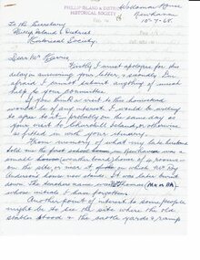
Letter, Letter from Mrs Ethel Cleeland re Island history 1968, 15/7/1968
She was Ethel Hartley who married John Blake Cleeland and died in 1984.The 1968 "back to" was to commemorate 100 years of settlement on the Island.HistoricalHandwritten 5 page letter to Mr Harris, secretary of PIDHS, re places of interest in Newhaven area and their history. Dated 15/7/1968 and written at Woolamai House, Newhaven. This was for the Back to Phillip Island in 1968.newhaven, mrs ethel cleeland, back to phillip island 1968, cape woolamai granite quarry, maritime safety, navigation light, mr finn stonemason, san remo - newhaven punt, cattle transport, newhaven school, boat building newhaven -
 Parks Victoria - Gabo Island Lightstation
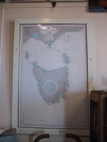
Chart, nautical, "Cape Otway to Gabo Island including Tasmania", April 1071
This mounted chart, dated 21 August 1971 is under glass in a wooden frame and covers Bass Strait between Cape Otway and Gabo Island, showing southern and eastern Victoria and the whole of Tasmania. The frame was possibly handmade locally. The charts are specific to the Gabo Island Lightstation and have second level contributory significance for their historic value and provenance to the lightstation.Blue / grey & white nautical chart of Cape Otway to Gabo Island . It is under glass and in a white painted wooden frame. The frame has three holes at the top left and the base.Top left-hand," AUS 422 DEPTHS IN FATHOMS......." -
 Flagstaff Hill Maritime Museum and Village
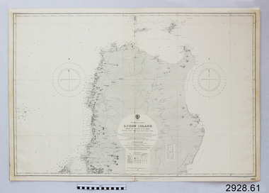
Document - Navigation Chart, Luzon Island, North of Latitude 16° 20' north
British Admiralty Navigation Chart - Phillippine Islands - Luzon Island, North of Latitude 16° 20' northwarrnambool, shipwrecked-coast, flagstaff-hill, flagstaff-hill-maritime-museum, maritime-museum, shipwreck-coast, flagstaff-hill-maritime-village, shipwrecked-artefact, navigation chart, british admiralty navigation chart, british admiralty, luzon island -
 Phillip Island and District Historical Society Inc.
Photograph - Post Card, 1960's
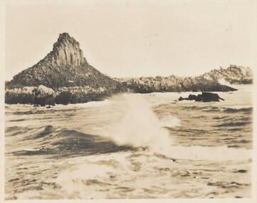
Donated by S. Serpell of Serpell & Reid families, SandringhamSepia Photo of Pyramid Rock, Phillip IslandPyramid Rock, Phillip Islandphillip island -
National Vietnam Veterans Museum (NVVM)
Film - Film, DVD, Seeker at Phillip Island - Australia, March 2007: authorised copy
Aerial shots of Phillip Islandphillip island - australia -
 National Vietnam Veterans Museum (NVVM)
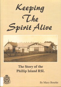
Book, Bourke, Mary, Keeping the Spirit Alive: The Story of the Phillip Island RSL
This book, Keeping the Spirit Alive, The Story of the Philip island RSL, is a journey through time and through the memories of its members.The story of the Phillip Island RSL.This book, Keeping the Spirit Alive, The Story of the Philip island RSL, is a journey through time and through the memories of its members.returned services league of australia. phillip island sub-branch -- history, veterans -- victoria -- phillip island -- history -
 Phillip Island and District Historical Society Inc.
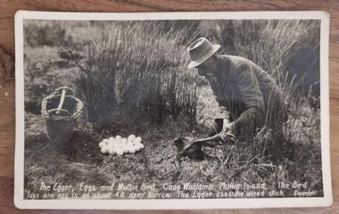
Photograph, The Egger, Eggs and Mutton Bird, Cape Woolamai, Phillip Island
Collecting mutton birds and eggs for food and cooking was a common practice on the IslandHistoricalBlack and white postcard of a man in a coat and hat, holding a mutton bird. A pile of eggs and a cane basket are nearby in sand dunes.The Egger, Eggs and Mutton Bird, Cape Woolamai, Phillip Island. The Bird lays one egg in an about 4 ft deep burrow. The Egger uses the wired stick.mutton birds, mutton bird eggers, cape woolamai -
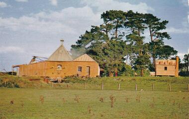 Phillip Island and District Historical Society Inc.
Photograph - Post Card, Chicory Kiln
One of a collection in an album donated by Bernard GraydenColoured Postcard of a Chicory Kiln on Phillip IslandOn Back: "Phillip Island, Victoria" "chicory is one of the Island's numerous crops; this scene shows a chicory kiln.chicory kiln, phillip island, bernard grayden, postcards -
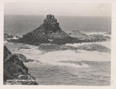 Phillip Island and District Historical Society Inc.
Photograph, 1940's
One of a collection of 15 photographs/postcards donated by Lois MullinsBlack & White photograph of Pyramid Rock, Phillip Island."Pyramid Rock, Phillip Island"pyramid rocks phillip island, phillip island coastline, rock formation phillip island, lois mullins