Showing 420 items
matching localities
-
 National Wool Museum
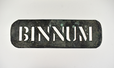
Stencil - BINNUM
This stencil was used as a location stamp for the transportation of wool bales. Binnum is a locality in South Australia. Wool bales marked BINNUM would have been transported to or from Binnum.Wool bale export stencil - BINNUMBINNUMwool transportation, wool exchange, wool sales -
 Eltham District Historical Society Inc
Map (item) - Sales Brochure, Plenty Township Estate and Bryn Teg Hill's Estate, Coghill & Haughton, Melbourne, c.1924
Plenty Township Estate "The rapid growth of Greensborough and the great traffic development on the main road between Heidelberg and Eltham augurs well for Plenty Township Estate. Already a Store, Post Office and State School have been started, and the activities of the Local Progress Association will help the district forward considerably. Within walking distance of the Montmorency and Greensborough stations." Bryn Teg Hill's Estate "Better known as "The Old Sand Hill, "within walking distance of the Montmorency and Greensborough railways stations." "Some few years back Mrs Thomas subdivided portion of the Sand Hill Paddocks, and the areas sold have been settled and many converted into charming outer suburban garden homes with cultivation and orchard plots. The south-eastern slope gives the land a grand outlook over the Yarra Valley on to the Dandenoings, and the are is very picturesque and homely." "A number of the blocks contain large deposits of valuable building sand, which should prove good speculation in view of the forecast for further rapid home development along the Eltham Suburban Electric Service." Sand Hills Road (Old Eltham Road) Date estimated as c.1924 - Electricification of railway line to Eltham referenced on map occured April 1923 and Mrs Mary Thomas died August 1925. Her home Bryn Teg became part of the Heidelberg Golf Club in 1927.The establishment of Lower Plenty as a suburban growth area supported by easy commuting facilitated by the elctrification of the Eltham railway linebonds road, bridge, bryn teg hill's estate, coghill & haughton, eltham road, heidelberg golf club hotel, houses, lower plenty, lower plenty bridge, lower plenty road, main road, plenty hotel, plenty river, plenty township estate, real estate agent, sales brochure, sand hills road, the old sand hill, sand hill paddocks, woodfull road, old eltham road, bryn teg, mrs m thomas -
 Kew Historical Society Inc
Plan - Subdivision Plan, Riversdale Estate, 1939
The Kew Historical Society collection includes almost 100 subdivision plans pertaining to suburbs of the City of Melbourne. Most of these are of Kew, Kew East or Studley Park, although a smaller number are plans of Camberwell, Deepdene, Balwyn and Hawthorn. It is believed that the majority of the plans were gifted to the Society by persons connected with the real estate firm - J. R. Mathers and McMillan, 136 Cotham Road, Kew. The Plans in the collection are rarely in pristine form, being working plans on which the agent would write notes and record lots sold and the prices of these. The subdivision plans are historically significant examples of the growth of urban Melbourne from the beginning of the 20th Century up until the 1980s. A number of the plans are double-sided and often include a photograph on the reverse. A number of the latter are by noted photographers such as J.E. Barnes.The Riversdale Estate in Hawthorn created a subdivision of 20 allotments bordering on Riversdale Road and Riversdale Court (which was created by the subdivision). The Locality Plan at right lists the major public buildings in the area: Burnely Horticultural Gardens, Hawthorn Tram Depot and Railway Station, Scotch College and the River Yarra and The Boulevard.subdivision plans - hawthorn, riversdale estate -
 The Beechworth Burke Museum
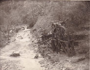
Postcard, 1920
This postcard depicts the set-up of an abandoned gold mine. This includes a water wheel and other mining implements next to a creek. The postcard inscription indicates that this image is of the remains of the Wallaby Reef battery and water wheel. Wallaby Reef was discovered in 1864, and a prospecting claim established a four head battery and water wheel. Quartz was mined there, with gold also discovered at this location at a later date. By 1878 the mine was no longer resulting in rich deposits, this resulted in the miners moving their search for gold closer to the river where they were able to access more gold. This was in approximately 1879. In 1882 a rich deposit was found. In 1908 the battery was closed, and the mine finished. This photo was taken in 1920 and shows the deterioration of the site since its closure. Gold mining was crucial to the development of the Beechworth area. It has strong research and historical value because the clarity of the photo shows all the minute details of the mining equipment. The text on the back also indicates the mine is the Wallaby Mine, which was used for 45 years to find gold and quartz. Therefore, due to the location being quickly abandoned, this site is a rich location for historical study on gold mining during the 1900s. It can provide important information on the types of tools utilised and the impact of the mining on the environment.Black and white postcard photograph on card.8169 Be / Also near Wallaby Reef Workings / Relics of Rechabite Reef (locality) workings. / Shaft in bed of creek. Wheel used to drive sheadd (?) / stamp battery too I believe near B'worth 1920?beechworth, mining, gold mining, quartz mining, wallaby reef mine, mine battery head -
 Bendigo Historical Society Inc.
Postcard - UNKNOWN FAMILY COLLECTION: PHOTOGRAPH
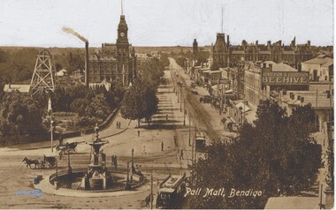
Postcard - black and white. Pall Mall, Bendigo. Written on back - Royal Historical Society of Victoria, Bendigo Branch. Hustlers Royal Reserve. Locality Pall Mall, Bendigo. R.S.L. Memorial Hall now occupies site. Added a colour photo/postcard, Pall Mall Bendigo, photo exactly the same.place, streetscape, pall mall, hustlers royal reserve. pall mall bendigo. -
 Bendigo Historical Society Inc.
Document - Forest Street, Bendigo. Properties Historic Details, 1970 to 1990s
51 Forest Street Bendigo Heritage Research Report and Certificate of Title (1993). 113 Forest Street Letter to the Bendigo Council in 1992 from the National Trust Bendigo (Apply to the Society for Details). 55 Forest Street Bendigo National Trust Survey Data File and Historical Notes on the locality (1974)history, national trust bendigo collection, bendigo, forest street -
Kew Historical Society Inc
Plan - Subdivisional Sale of 11 Villa Sites, East Kew, 1939
Subdivision plans and real estate flyers/brochures reveal a number of aspects of urban development and history. The Kew Historical Society's collection of these plans, as well as advertisements extracted from magazines, cover key aspects of community development and architectural history of Kew and Kew Eat as well as surrounding suburbs. While most of the plans in the collection were gifted to the Society by the former City of Kew, a number of other plans and advertisements have been donated by individuals, of which this is an example.Single page residential subdivision plan advertising house lots for sale, in what was then designated as East Kew but is now Kew, in the following streets: Burke Road, Enfield Street. The flyer includes a smaller locality plan at right. Information on the flyer indicates that the land was previously owned by the Melbourne & Metropolitan Tramways Board.subdivision plans -- kew (vic.), enfield street -- kew (vic.), burke road -- kew (vic.) -
 Ringwood and District Historical Society
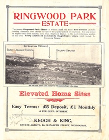
Flyer, Sub-divisional residential land sale advertisement - Ringwood Park Estate, Ringwood, Vic. - circa 1922
Folded double-sided page with black and white photographs of local views with black and red print advertising elevated home sites, including terms of sale, locality map, and description of local facilities and services, with blocks marked as SOLD subsequent to auction sale December 1922. (See Record ID no.5249)Subdivision includes Wonga Road (later Loughnan Road), William Street, Andrew Street, Munro Street and Harrison Street. Estate Agents - Keogh & King, 70 Elizabeth Street, Melbourne, Telephone 6938. -
 Wodonga & District Historical Society Inc
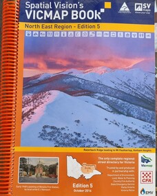
Book - Spatial Vision's VICMAP BOOK 2016 - Northeast Region, Spatial Vision Innovations Pty Ltd, 2016
This edition of Spatial Vision's VicMap Book North East Region was published in October 2016 and provides detailed topographic maps for the region. It was used by emergency services and various agencies, including the Country Fire Authority (CFA). It covers areas including Wodonga, Albury, Wangaratta, and beyond, including national parks and recreation areas. Text on the cover states that the volume is "Trusted by and produced in partnership with: Department of Environment, Land, Water & Planning, Country Fire Authority, State Emergency Service, Parks Victoria, Victoria Police".A spiral bound volume of 409 pages including colour topographic maps and illustrations of North East Victoria. The cover features a colour photo of Razorback Ridge leading to Mount Feathertop, Hotham Heights, Victoria. It also features an index map inside the front cover, a legend, road index, and locality index.This edition of Spatial Vision's VicMap Book North East Region was published in October 2016 and provides detailed topographic maps for the region. It was used by emergency services and various agencies, including the Country Fire Authority (CFA). It covers areas including Wodonga, Albury, Wangaratta, and beyond, including national parks and recreation areas. Text on the cover states that the volume is "Trusted by and produced in partnership with: Department of Environment, Land, Water & Planning, Country Fire Authority, State Emergency Service, Parks Victoria, Victoria Police".emergency management north east victoria, state emergency service, cfa wodonga -
 Eltham District Historical Society Inc
Book, D. Pendavingh, Yarra River Trail Plan 1989: Banksia Street to Warrandyte, 1989
Also contains a loose A3 mylar plan inserted - Depart of Planning and Urban Growth, Heidelberg; Main Yarra Trail; Warringal Parklands and Banyule Flats, Detail Plan and Locality Plan -
 National Wool Museum
Stencil - MODELLA
This stencil was used as a location stamp for the transportation of wool bales. Modella is a bounded rural locality in Victoria, Australia. Wool bales marked MODELLA would have been transported to or from Modella.Wool bale export stencil - MODELLAMODELLAwool - transportation, wool sales, wool class, wool classers -
 Whitehorse Historical Society Inc.
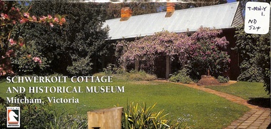
Pamphlet, Schwerkolt Cottage and Historical Museum, 1/06/1998
Whitehorse City Council publicity pamphlet giving the history of the cottage and the Schwerkolt family. Includes the farm in Separation Street, Northcote. In Mitcham the farm was a 'mixed' one with fruit trees, vines, dairying, poultry, bee hives, wine making and a stone quarry. Includes details of the museum, coloured photographs and locality and site plans.jackschowsky, mary elizabeth, schwerkolt, johann august, richter, paulina, oppel, maria catherina wilhelmine, deep creek road, mitcham, city of whitehorse, nunawading and district historical society inc, city of nunawading, delacombe, rohan (sir), schwerkolt cottage -
 Bacchus Marsh & District Historical Society
Map, Balliang Parish Map, County of Grant c.1907
A single page paper map showing parish plan map for Balliang. This parish area contains the localities of Balliang and Balliang East and is located south of the township of Bacchus Marsh. The map is pasted into a bound volume containing 76 maps or plans in total. High resolution digital image stored on BMDHS computer network. balliang victoria maps, balliang parish maps -
 Bendigo Historical Society Inc.
Document - PETER ELLIS COLLECTION: REMARKS ON PROPOSED NATIONAL PARK AREA
Some Introductory Remarks on the Proposed National Park Area in Parishes of Mandurang and Sandhurst printed on yellow foolscap paper. Short description of the area. Common names and scientific names of many plants that grow in the area. Some descriptions and localities mentioned. 4 1/2 pages of species (249) and families (56) mentioned.bendigo, parks and gardens, national parks, peter ellis collection, wild flowers -
Southern Sherbrooke Historical Society Inc.
Map - photocopy
A photocopy taken from the original land sale map provided to the society through Karel Coxell of Stockdale & Leggo. The original maps are stored in large bound account books and were originally the propert of McNally Real Estate. The books are held (in 2A3 photocopy of plan of survey of part of Crown Allotments 20 & 21, section C, parish of Narre Worran, County of Mornington. Clements Ave and environs in Belgrave Heights"Villette Estate" in top LH corner, "Locality Plan" in bottom LH corner, "Not in sale" written on one block and crossed out. All handwritten in pencil on original. "Colby Drive " and "Verona Street" added in pencil to copy.land sales, advertisements, subdivision -
 Greensborough Historical Society
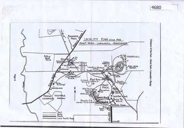
Map, Mont Park buildings still existing, 1946_
Locality Plan indicates buildings still existing within the Mont Park - Larundel mental health complex; Table lists 16 buildings by year built, initial purpose, subsequent uses and current address2 pages,one map, one table larundel, mont park -
Eltham District Historical Society Inc
Ledger, Contract Register; Country Roads Board, Shire of Eltham, 1933
Ledger describing name and address of contractor, description and locality, particulars, schedule of tender (description incl quantities and price) and payments - hand written. Ledger maintained for period 1933-1964 and contains 97 entries.Hard cover bound ledger with leather corners and spine and pre-printed columns -
 Old School House Museum
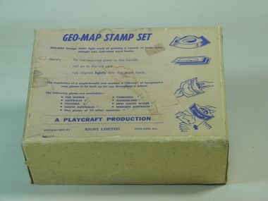
Rubber Stamp Set
Used by teachers for teaching geography, they would take the plate and attach to the handle, stamp it into ink and would make multiple copies for the students to either identify capital and countries or to learn the shape and localities of each locationIt was an early way of making multiple copies for teaching students.Geography stamp set in box which include 4 plates and handle. Plates include, Asia,Africa,Victoria,The world Geo-Map Stamp Setfrankston primary school, rubber stamps, education, geo-map, victoria, asia, the world, africa, playcraft production -
 Federation University Historical Collection
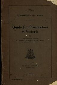
Book, Guide for Prospectors in Victoria, 1931, 1931
The handbook was intended for those with little experience who wanted to prospect of fossick.Grey soft covered book of 90 pages. Includes fold out map of a portion of Victoria showing auriferous areas and mineral localities. Also show Counties of Victoria and localities of minerals such as tin, antimony, copper, silver lead, Malybdenite, tungsten ores, manganese, platinum, osmiridium and iron. Chapter heading s include: working alluvial deposits, equipment, geology of Victoria, gold deposits, quartz reefs, indicators, economic minerals, assistance to prospectors, Miners' Right, mining bye-law, mining leases, forest regulations and glossary. Descriptions are given of a god dish, puddling tub, cradle, puddling machine, ground sluicing, boring, windlass, whim, hand dollying, sweeping, California pump, and wing dam.mining, baragwanath, gold, prospector, geology, quartz reefs, alluvial deposits, indicators, victorian goldfields, miners rights, mining leases, forest regulations, sluicing, sluice box, puddling machine, miner's cradle, whim, whip, california pump, gold nuggets, saddle reef, ballarat indicators, state batteries -
 Kew Historical Society Inc
Plan - Subdivision Plan, Belford Heights Estate, Kew, ca. 1925
Pru Sanderson, in her groundbreaking ‘City of Kew Urban Conservation Study : Volume 2 - Development History’ (1988), summarised the periods of urban development and subdivisions of land in Kew. The periods that she identified included 1845-1880, 1880-1893, 1893-1921, 1921-1933, 1933-1943, and Post-War Development. These periods were selected as they represented periods of rapid growth or decline in urban development. An obvious starting point for Sanderson’s groupings involved population growth and the associated economic cycles. These cycles also highlighted urban expansion onto land that was predominantly rural, although in other cases it represented the decline and breakup of large estates. A number of the plans in the Kew Historical Society’s collection can also be found in other collections, such as those of the State Library of Victoria and the Boroondara Library Service. A number are however unique to the collection.The Kew Historical Society collection includes almost 100 subdivision plans pertaining to suburbs of the City of Melbourne. Most of these are of Kew, Kew East or Studley Park, although a smaller number are plans of Camberwell, Deepdene, Balwyn and Hawthorn. It is believed that the majority of the plans were gifted to the Society by persons connected with the real estate firm - J. R. Mathers and McMillan, 136 Cotham Road, Kew. The Plans in the collection are rarely in pristine form, being working plans on which the agent would write notes and record lots sold and the prices of these. The subdivision plans are historically significant examples of the growth of urban Melbourne from the beginning of the 20th Century up until the 1980s. A number of the plans are double-sided and often include a photograph on the reverse. A number of the latter are by noted photographers such as J.E. Barnes.The Belford Heights Estate was a subdivision in Kew East, even though the title of the plan indicates that it was located in Kew. The subdivision had been approved by 1915, and included 105 lots facing Strathalbyn, Kitchener, Hamilton and Beresford Streets, as well as Balfour and Belford Roads. Those lots hand coloured with red probably represent blocks that had been sold. The additional information provided on the plan is also of interest. The plan includes the original location of East Kew State (Primary) School in Strathalbyn Street, which opened in 1892. The inset Locality Plan also includes the route of the Outer Circle Railway and the location of the Wilsmere and East Kew Stations. The location of the landmark Harp of Erin Hotel is also marked on the Locality Plan.belford heights estate, subdivision plans - kew -
 Federation University Historical Collection
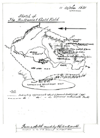
Plan, Sketch of Ballaarat Gold-Field, 1851, 11/10/1851
The sketch was made by A.C. MacDonald, F.R.G.S. and presented to James Oddie, who was one of the earliest gold diggers at Ballarat..1) Reproduction of a line sketch plan of the Ballarat goldfield as it was on 11 October 1851 as drawn by A.C. MacDonald, and recopied by C.M. Yelland. The dots indicate appoximate extent of the Ballarat Goldfield in 1851. The dot and dash line indicates approximate area covered with tents. .2) Includes an indication of the locality of the Township of Baallarat West in 1867. Verso of cat. No. 4296.2, and written by Keith Rash - "On 10th October 1851, 1,300 licenses had been issued. 30th October 1851 2246 licenses. Lieut. Gov. LaTobe letter to Earl Grey." james oddie, a c macdonald, gold commissioner, mcleod, alfred clark, kavanagh, willis, highett, yarrowee river, a.c. macdonald, ballarat goldfield, ballaarat goldfield, lamda, c.m. yelland -
Glen Eira Historical Society
Book - MOORABBIN
One item about Moorabbin: 1/An A4 directory of services, clubs, organisations, amenities, sport and recreation facilities, and associations within the Moorabbin City Council’s locality. It has been produced by the City Council in 1987directories, city of moorabbin, sports and recreations, establishment, clubs, local government, clubs and associations, sport and recreation, service clubs, businesses, sporting, social services, social clubs, community services, community centres, community groups, community organisations, east ormond, south oakleigh, moorabbin, patterson, mckinnon, ormond, bentleigh, bentleigh east -
 Ringwood and District Historical Society
Map, Proposed Subdivision - Hilltop Estate, Heathmont, Victoria - circa 1925
Plan of Part of Crown Allotments 16 & 18, Parish of Ringwood, County of Mornington. Subdivision includes Site for Heathmont Station, Heathmont Road, George Street, Lilian Street, Edith Street, Edna Street, Great Ryrie Street. Inset locality plan also shows nearby Electric Railway Estate and Heathmont Station Estate. L.H. Webber, Licensed Surveyor, 440 Little Collins Street, Melbourne. -
Ringwood and District Historical Society
Envelope, Packet: Ringwood Area Hotels - Coach and Horses, Empress India, Burnt Bridge. Also Antimony Mine Hotel Proclaimed 1878
Hotels list; Coach and Horses Hotel; Club Hotel Sept-1887 Wiggin sold to Lindsey; Empress India Hotel; Antimony Mine Hotel, East Ringwood, Cnr Main & Pratt St proclaimed 21-Jan-1878 owing to increase in mining population, 4 licences in locality; Burnt Bridge Hotel; "Duke of York" -
Federation University Historical Collection
Book, Ballarat School of Mines Assay Register, 1890-1899, 1890-1899
Marble card covered book with blue/black spine. The pages are ruled into columns and headed: Date received, Reg. No. Private Mark, Substance, Locality, Submitted by, Assay, Remarks, Report. Some mines submitting substance for assay include Britannia UNited (J.M. Bickett), Golden Ridge, CLunes UNited, NOrth Cornish Mine Daylesford.ballarat school of mines, assay register, mining -
Bendigo Historical Society Inc.
Map - CAMPBELL COLLECTION: BENDIGO AND DISTRICT MAPS, 21-8-1972
Map. Shire of Strathfieldsaye, Locality Plan. Scale I inch=1 mile. Shire of Huntly, Shire of McIvor, City of Bendigo, Shire of Marong, Shire of Maldon, Shire of Metcalfe. Lake Eppalock. Mileage markers on some roads. Melbourne to Bendigo Railway Line, Big Hill Tunnel, Mt.Herbert 1596.Axedale Township, Strathfieldsaye Township.M.Higgs 21-8-1972map, bendigo, locality plan -
 Bendigo Historical Society Inc.
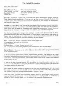
Document - THE UNITED DEVONSHIRE MINE - NOTES ON THE UNITED DEVONSHIRE MINE
One handwritten and three typed copies of notes on The United Devonshire Mine on the New Chum Line of Reef. Notes include size of lease, depth of shaft, East Shaft, locality, a warning on the area where the shaft is, plant, early history. Leading and Prominent, Best Gold, Total Yields and Dividends. Notes prepared by Albert Richardson.document, gold, the united devonshire mine, the united devonshire mine, notes on the united devonshire mine, california hill state school, freeman & coy, the 'danes', princess alexandra, the premier coy, saxon & celt, south devonshire, new st mungo, duke of edinburgh, phoenix mine, duchess tribute, duchess of edinburgh, albert battery, mines dept special edition australian mining standard 1/6/1899, mines dept booklet bendigo goldfields 1936, mines dept annual and quarterly reports, annals of bendigo mining sections 1881 - 1916, a richardson, mines dept bulletin no 47 structure of bendigo goldfield h herman 1923, the bendigo goldfield registry j n macartney 1/3/1871 -
Bendigo Historical Society Inc.
Document - NEW MOON MINE - NOTES ON THE NEW MOON MINE
Handwritten notes on the New Moon Mine on the Garden Gully Line of Reef. Notes include depth of Shaft, locality, Formation & Registration, Last year of production 1931, Size of lease, Early History, Plant, Poppet Legs, Telephone & Electric Signalling, Gold Obtained, Prominence, Total Gold Production and Dividends. ( duplicate of record 3559.1)document, gold, new moon mine, new moon mine, notes on the new moon mine, garden gully line of reef, prospector's vote, h harkness & coy, thompson & co of castlemaine, bendigo amalgamated goldfields coy, mines dept special edition australian mining standard 1/6/1899, mines dept booklet bendigo goldfield geo brown 1936, mines dept annual and quarterly reports, annals of bendigo mining sections 1907 to 1931, a richardson, souvenir declaration 200th dividend issued by directors new moon 1/12/1906, mines dept bulletin no 47 structure of bendigo goldfield h herman 1923 -
 Federation University Historical Collection
Map, Municipality of Ballarat East, 1857
Gold was discovered in Ballarat in 1851. This plan was created six years later and names some of the great gold locations of Ballarat East. It also shows the locality of the Eureka Stockade (1854) and the walking tracks and roads on the Ballarat East Goldfield.In 2007 this map was listed on the inaugural Ballarat Treasure's Register.Large map backed onto linen. The map has read and blue highlights, and identifies areas such as Mount Pleasant, Golden Point, White Flat, Nightingale, Malekoff, Old Post Office Hill, Red streak, Gumtree Flat, Old Gravelpits, Bakery Hill, Ballaarat Flat, The Camp, Specimen Gully, Pennyweight Hill, Warrenheip Gully, Gays Gully, Pennyweight Flat, Eureka, Black Hill, Pinchgut, Crocodile, Hit or Miss, Little Bendigo, Brown Hill, Mopoke, Cricket Reserve, Canadian Hotel, Ballarat Eastmount pleasant, golden point, white flat, nightingale, malekoff, old post office hill, red streak, gumtree flat, old gravelpits, bakery hill, ballaarat flat, the camp, specimen gully, pennyweight hill, warrenheip gully, gays gully, pennyweight flat, eureka, black hill, pinchgut, crocodile, hit or miss, little bendigo, brown hill, mopoke, cricket reserve, canadian hotel, ballarat eastm phillips, john phillips, field draughtsman, ballarat east, ballarat east map -
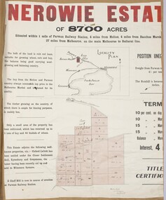 Bacchus Marsh & District Historical Society
Map, Nerowie Estate Land Sale 1910
The Nerowie Estate was a large rural property of 8,700 acres (3520 hectares) near the locality of Parwan only a few kilometers east of Bacchus Marsh. It had once formed a large part of the land owned by the pioneering Staughton family.A single page paper map showing the land offered for sale from the Nerowie Estate at Parwan near Bacchus Marsh in 1910. The map is pasted into a bound volume containing 76 maps or plans in total. High resolution digital image stored on BMDHS computer network. nerowie estate parwan, land sales parwan, land sales bacchus marsh, staughton family bacchus marsh