Showing 203 items
matching long border
-
 Kew Historical Society Inc
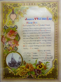
Certificate - Certificate of Appreciation to Mr John Watson Esq, Kew Methodist Church, 1907
"METHODIST CHURCH. In 1881, during the ministry of Rev. W. H. Fitchett, B.A., at Hawthorn, a number of members of the denomination living at Kew considered that the time was opportune for founding a local Church. The Superintendent of the Circuit, the Rev. W. A. Quick of Richmond, met the members and formed them into a society class under the leadership of Mr. A. Brown and a Church was formally instituted at the house of Mr. T. J. Eaton, of Eglinton Street, in December, 1881. Services were regularly held for some time at the same place, and funds for purchasing a block of land were gradually collected, resulting in the present site in Highbury Grove being purchased for £350. Messrs. W. Cleverdon, A. Money, T. E. Serpell, and T. Vasey, of Hawthorn, and Messrs. A. Brown, R. Eyre, and T. J. Eaton of Kew, were appointed trustees. A public meeting was held a the Town Hall, when over £100 was raised. The Rev. John Harcourt, who had just been placed on the supernumerary list, was persuaded to undertake the charge, and commenced services in the Town Hall on 29th April, 1882, which were continued for eighteen months. A Sunday School was started, and altogether the effort progressed so satisfactorily that in October, 1882, the foundation and memorial stones of the present Church were laid by Mr James Huddart. At the tea meeting held in connection with this event nearly £200 was raised and a few months later £250 more was obtained by means of a bazaar. The contract for building Church was let for £1,200. The Sunday School celebrated its first anniversary in June, and the Church was opened on 7th October 1883, the preachers on the occasion being Revs. E. J. Watkin, S. Chapman, and John Harcourt, the collections amounting to £230. Towards raising these sums of money the ladies of the congregation helped very materially. In 1886 the foundation stone of a Sunday school, to cost about £900, was laid by Mrs. H Berry, the building being opened in April 1887. During the same year the Church was enlarged. In 1889 parsonage was erected, and again arrangements had to be made for a further enlargement of the Church, at a cost of nearly £2,000. The foundation stones of the tower were laid by Rev J. Harcourt, and of the transepts by Mrs. Job Smith and Mrs. John Watson. These additions were made during the ministry of Rev. P. R. C. Ussher, the first minister appointed to Kew by conference. He has been succeeded by Revs. Henry Howard, J. de Q. Robin, J. J. Brown, J. G. Wheen, A. E. Albiston, M.A., and F. J. Nance, M.A., who is at present ably filling the pulpit. For the musical portion of the services, the Church has been greatly indebted to the enthusiasm of Mr. C. Gardner, the leader of the choir, and Mr. C. E. Gardner, the organist. The Sunday School has had a number of excellent workers, among whom may be mentioned Messrs. Burchett, Allum, Hillard, Tonkin, Dent, Avery, McDonald, Green, and B. Hoadley, who have acted as Superintendents, and Messrs. Arnall and McCaghern as Secretaries. The present trustees are Messrs. H. Berry, Job Smith, A. Hoadley, F. Vial, C. Powers, H. L. Carnegie, C. H. Green, W. R. Rylah, E. M. Tonkin, S. Gaylard, J. Gregory, J. R. McDonald, T. J. Eaton, F. S. Fitchett, and S. Lamble; Society Stewards, T. J. Eaton and B. Hoadley; Poor Stewards, G. Hinchliffe and G. Fraser; Church Stewards, C. H. Green and G. Hinchliffe; Treasurer, F. S. Fitchett; Secretary, S. Lamble." Source: FGA Barnard, Jubilee History of Kew, Victoria, 1910Commemorative tributes were regularly produced in the 19th and early 20th Century to honour community service. Most were adapted from traditional lithographed models. This example, while created within a formal lithographed border has been transmuted into the equivalent of an illuminated document, hand-painted, and therefore rare. The use of flowers in the design emphasises the sentimental and spiritual aspects of the certificate. The document is a rare unique record of the Kew Methodist Church's history.A hand written testimonial for John Watson Esq from the Trustees of the Kew Methodist Church. The customised colour lithograph includes, at lower left, a turn of the century photograph of the Kew Methodist Church in Highbury Grove. The entire certificate is surrounded by floral art and scroll work. The central text uses neo-gothic lettering.‘Dear Sir … in view of your compulsory retirement on health grounds, from the position of Church Steward, [the Trustees] desire to express their great appreciation of your long service of over 22 years, in that and other offices in the Church. They trust that you will yet be spared many years in fellowship with our Church, and that God’s richest blessing be on you, and your family. We remain, Yours sincerely A. E. Albiston (Minister), S. Lamble (Secretary), F. S. Fitchett (Treasurer), T. J. Eaton (Trustee), C. H. Green and Hubert S. Howell (Church Stewards); March 28th 1907’. john watson esq, kew methodist church, highbury grove, certificates, tesimonials -
 Kew Historical Society Inc
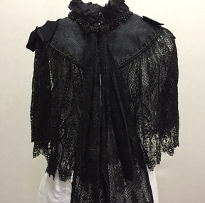
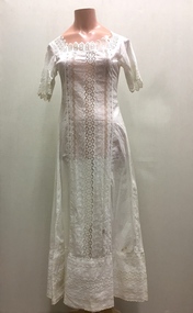
Clothing, Black Silk, Lace & Jet Cape, 1980s
The Fashion & Design collection of the Kew Historical Society includes examples of women’s, men’s, children’s and infants’ clothing from the 18th, 19th and 20th centuries. Items in the collection were largely produced for, or purchased by women in Melbourne, and includes examples of outerwear, protective wear, nightwear, underwear and costume accessories.Late Victorian black watered silk cape with a wide border of machine made lace. The cape is extensively adorned with beads of black jet. Two long pieces of black lace fall from the neck at centre front. The cape was owned by one of the donor's maternal ancestors.capes, australian fashion, women's clothing, victorian fashion -
 Kew Historical Society Inc
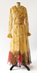
Clothing - Full-length Multicoloured Patchwork Skirt, Grace James, 1988
Grace James, the creator of the items in the Grace James collection, designed and created costumes over a 19 year period (1969-1988) for her daughter Ceri. The collection of clothing ranges from evening wear to knitted garments. All the items display exemplary dressmaking skills. The designs are of the period and reflect evolving fashions of the time. Some items are copies of published designs whereas others are original creations. The collection was donated in 2006.While most of the items in the Fashion & Design Collection of the Kew Historical Society are commercially designed items of clothing, there are also items made by home dressmakers. Many of these exhibit outstanding design knowledge and technical skills. A large and important group of these items of women's clothing is contained in the Grace James collection of outfits created for the dressmaker's daughter. The items have additional significance due to information about the purpose of the creation and the date when it was constructed.Long silk taffeta skirt made of patchwork silk pieces/panels with a matching silk scarf. The patchwork panels are in shades of pinks, purples and blues. The skirt is secured with clear plastic press-studs. A narrow internal border of lace is attached to the basque.grace james, women's clothing, australian fashion 1969-1988, dressmakers - surrey hills (vic), fashion design, fashion -- 1980s -
 Kew Historical Society Inc
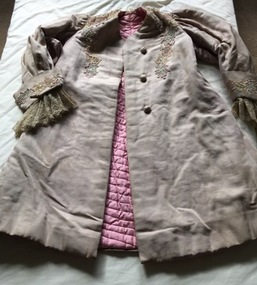
Clothing - Silk & Guipure Lace Evening Coat with Quilted Pink Silk Lining, 1920s
An item forming part of a collection of costumes, photographs and documents relating to the Weir family who lived in a mansion, originally named Illapa, at 84 Princess Street, Kew, from c.1917 to 1950. This historically significant collection includes items relating to both George Weir (1866-1937), his wife Edith Mary Weir (1867-1948) and their children. George Weir attained national prominence in the mining industry, becoming General Manager of the North Broken Hill Silver Mining Company in 1903 (later renamed North Broken Hill Mining Company 1905-12, and North Broken Hill Ltd 1912-1988), and subsequently President of the Mine Owners Association. He was to remain General Manager of North Broken Hill Ltd until his retirement in 1926.This garment is part of a collection of women’s clothing, owned and worn by Edith Mary Weir (nee Betteridge) - born in Clare, South Australia 1867, died Kew 1948 - and also by her daughter. The garments date from the 1880s to the 1930s. The collection includes day dresses, evening dresses, evening coats, capes, and undergarments. As the wife and daughter of a mine manager, the collection includes representative examples of clothing worn by upper middle class Australian women in domestic circumstances, and at social and civic events. A number of the costumes from the 1920s to the 1930s are of a particularly fine quality, being both rare, representative and intact examples of Australian fashion of the period. The garments in the Weir Collection were donated to the Kew Historical Society by a granddaughter of Edith Weir in 2017.Beige silk theatre or opera jacket with multi-coloured guipure lace at the neck, on the front bordering the opening, and on the cuffs. The long sleeves have extensive old lace extending beyond the wide cuffs. The inside is lined with quilted pink silk, which has darker silk panels at the front. The jacket has a high neck. It is closed using three embroidered fabric buttons at the frontedith mary weir (nee betteridge), 84 princess street - kew, australian fashion, women's clothing, costumes, coats -
 Kew Historical Society Inc
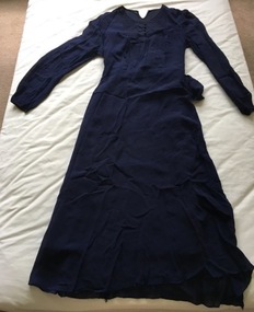
Clothing - Navy Blue Day Dress, 1910s
An item forming part of a collection of costumes, photographs and documents relating to the Weir family who lived in a mansion, originally named Illapa, at 84 Princess Street, Kew, from c.1917 to 1950. This historically significant collection includes items relating to both George Weir (1866-1937), his wife Edith Mary Weir (1867-1948) and their children. George Weir attained national prominence in the mining industry, becoming General Manager of the North Broken Hill Silver Mining Company in 1903 (later renamed North Broken Hill Mining Company 1905-12, and North Broken Hill Ltd 1912-1988), and subsequently President of the Mine Owners Association. He was to remain General Manager of North Broken Hill Ltd until his retirement in 1926.This garment is part of a collection of women’s clothing, owned and worn by Edith Mary Weir (nee Betteridge) - born in Clare, South Australia 1867, died Kew 1948 - and also by her daughter. The garments date from the 1880s to the 1930s. The collection includes day dresses, evening dresses, evening coats, capes, and undergarments. As the wife and daughter of a mine manager, the collection includes representative examples of clothing worn by upper middle class Australian women in domestic circumstances, and at social and civic events. A number of the costumes from the 1920s to the 1930s are of a particularly fine quality, being both rare, representative and intact examples of Australian fashion of the period. The garments in the Weir Collection were donated to the Kew Historical Society by a granddaughter of Edith Weir in 2017.Long navy blue crepe fitted dress featuring long narrow sleeves. The round-necked bodice includes buttons at the neck bordered by navy blue silk embroidery. The dress has a deep pocket in the same fabric at the right front beneath the waist.edith mary weir (nee betteridge), 84 princess street - kew, australian fashion, women's clothing, costumes, dresses -
 Kew Historical Society Inc
Clothing - Cotton & Lace Petticoat, c. 1901-08
An item forming part of a collection of costumes, photographs and documents relating to the Weir family who lived in the mansion originally named Illapa, 84 Princess Street, Kew, from c.1917 to 1950. This historically significant collection includes items relating to both George Weir (1866-1937) and his wife Edith Mary Weir (1867-1948). George Weir attained national prominence in the mining industry, becoming General Manager of the North Broken Hill Silver Mining Company in 1903 (later renamed North Broken Hill Mining Company 1905-12, and North Broken Hill Ltd 1912-1988), and subsequently President of the Mine Owners Association. He was to remain General Manager of North Broken Hill Ltd until his retirement in 1926.This garment is part of a collection of women’s clothing, owned and worn by Edith Mary Weir (nee Betteridge) - born in Clare, South Australia 1867, died Kew 1948 - and also by her daughter. The garments date from the 1880s to the 1930s. The collection includes day dresses, evening dresses, evening coats, capes, and undergarments. As the wife and daughter of a mine manager, the collection includes representative examples of clothing worn by upper middle class Australian women in domestic circumstances, and at social and civic events. A number of the costumes from the 1920s to the 1930s are of a particularly fine quality, being both rare, representative and intact examples of Australian fashion of the period. The garments in the Weir Collection were donated to the Kew Historical Society by a granddaughter of Edith Weir in 2017.Long white Indian cotton petticoat with broad panels of lace at the front and at the base. The short sleeves are bordered with the same lace. The most distinctive use of the lace it at the neck.edith mary weir (nee betteridge), 84 princess street - kew, women's clothing, costumes, underwear, petticoats -
 Kew Historical Society Inc
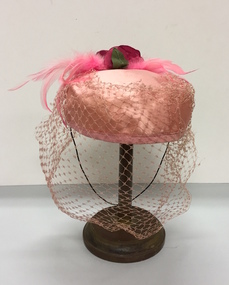
Headwear - Pink Silk & Net 'Pillbox' Hat, Stella Long, 1960s
Stella Long's millinery business was located in the Block Arcade Melbourne. She was one of the best known Melbourne milliners during the 1950s and 1960s.The Kew Historical Society’s fashion and design collection is comprised of costumes, hats, shoes and personal accessories. Many of these items were purchased or handmade in Victoria; some locally in Kew. The extensive hat collection comprises items dating from the 1860s to the 1970s. While most of the hats in the collection were created by milliners for women, there are a number of early and important men’s hats in the collection. The headwear collection is particularly significant in that it includes the work of notable Australian and international milliners.Pale pink silk circular hat bordered with darker pink satin, and crowned with pink feathers and a silk rose, all draped with pink net. The hat was retailed by Stella Long, 14 Block Arcade, Melbourne. Label: Original model from Stella Long. 14 Block Arcade Melb. 638507.milliners -- melbourne (vic. -- stella long, milliners -- stella long -- block arcade, women's clothing -- hats, headwear -
 Kew Historical Society Inc
Map, MMBW, MMBW Town of Kew, 1910-21
The Melbourne and Metropolitan Board of Works (MMBW) was established by an act of the Victorian Parliament in 1890 to prepare for and to implement a sewerage and water reticulation system across what was then inner Melbourne, its surrounding and middle distance suburbs, including Kew. The MMBW was disbanded in 1991.The map collection of the Kew Historical Society has at its core the historic maps assembled and originally stored in the City Engineer's Department of the City of Kew. These include maps in a number of scales. The vast majority of maps were produced by the MMBW in the first two decades of the twentieth century, and are solid working maps, backed by linen for durability. These maps are historically significant to Kew, the City of Boroondara and to the history of the development of state utilities in Victoria. A number of the Kew maps have additional details added by former municipal officers, including the levels reached by various floods. As these were working documents, information was added to them long after the period of their initial production and distribution.Early map of the Town of Kew, created after 1910, at a scale 440 ft to 1 inch. The 'assembled' map by the City of Kew Engineer's Department includes scaled down copies of The Melbourne and Metropolitan Board of Works maps, Nos. 39, 40, 64, 65, 66, 67, 68, and 117. The map covers the entirety of the Town of Kew, bordered on its north and west by the River Yarra, by Burke Road in the East and Barkers Road in the south. The map shows the extent of urban development by that time, prominent institutions and the outlines of built structures in the municipality. TOWN OF KEW / SCALE 400 FEET TO 1 INCHmelbourne & metropolitan board of works, mmbw maps, mmbw plans, town of kew, cartography -
 Kew Historical Society Inc
Map, MMBW, MMBW Plan No.39 Kew & Heidelberg, 1900-1910
The Melbourne and Metropolitan Board of Works (MMBW) was established by an act of the Victorian Parliament in 1890 to prepare for and to implement a sewerage and water reticulation system across what was then inner Melbourne, its surrounding and middle distance suburbs, including Kew. The MMBW was disbanded in 1991.The map collection of the Kew Historical Society has at its core the historic maps assembled and originally stored in the City Engineer's Department of the City of Kew. These include maps in a number of scales. The vast majority of maps were produced by the MMBW in the first two decades of the twentieth century, and are solid working maps, backed by linen for durability. These maps are historically significant to Kew, the City of Boroondara and to the history of the development of state utilities in Victoria. A number of the Kew maps have additional details added by former municipal officers, including the levels reached by various floods. As these were working documents, information was added to them long after the period of their initial production and distribution.Early map of part of the Borough of Kew, created in the first decade of the twentieth century, at a scale 160 ft to 1 inch. The map covers what was then the north western section of Kew, bordered on its north by Wills Street and the Kew Lunatic Asylum, in the west by the River Yarra [and the later added Yarra Boulevard] , by Princess Street in the East and Holroyd Street in the south. The map shows the extent of urban development by that time, prominent institutions and the outlines of built structures in the municipality. Contour lines were added in ink to the map at a later stage.MELBOURNE AND METROPOLITAN BOARD OF WORKS / PLAN NO. 39 / KEW & HEIDELBERGmelbourne & metropolitan board of works, mmbw maps, mmbw plans, borough of kew, cartography -
 Kew Historical Society Inc
Map, MMBW, MMBW Plan No.40 Collingwood & Kew, 1900-1910
The Melbourne and Metropolitan Board of Works (MMBW) was established by an act of the Victorian Parliament in 1890 to prepare for and to implement a sewerage and water reticulation system across what was then inner Melbourne, its surrounding and middle distance suburbs, including Kew. The MMBW was disbanded in 1991.The map collection of the Kew Historical Society has at its core the historic maps assembled and originally stored in the City Engineer's Department of the City of Kew. These include maps in a number of scales. The vast majority of maps were produced by the MMBW in the first two decades of the twentieth century, and are solid working maps, backed by linen for durability. These maps are historically significant to Kew, the City of Boroondara and to the history of the development of state utilities in Victoria. A number of the Kew maps have additional details added by former municipal officers, including the levels reached by various floods. As these were working documents, information was added to them long after the period of their initial production and distribution.Early map of part of the Borough of Kew, created in the first decade of the twentieth century, at a scale 160 ft to 1 inch. The map covers what was then the south western section of Kew, bordered on its north by Studley Park Road, in the west by Walmer Street and the River Yarra, by High Street South and Princess Street in the East and Barkers Road in the south. The map shows the extent of urban development by that time, prominent institutions and the outlines of built structures in the municipality. Contour lines and historic flood levels were added in ink to the map at a later stage.MELBOURNE AND METROPOLITAN BOARD OF WORKS / PLAN NO. 40 / COLLINGWOOD & KEWmelbourne & metropolitan board of works, mmbw maps, mmbw plans, borough of kew, cartography -
 Kew Historical Society Inc
Map, MMBW, MMBW Plan No.64 Kew & Heidelberg, 1900-1910
The Melbourne and Metropolitan Board of Works (MMBW) was established by an act of the Victorian Parliament in 1890 to prepare for and to implement a sewerage and water reticulation system across what was then inner Melbourne, its surrounding and middle distance suburbs, including Kew. The MMBW was disbanded in 1991.The map collection of the Kew Historical Society has at its core the historic maps assembled and originally stored in the City Engineer's Department of the City of Kew. These include maps in a number of scales. The vast majority of maps were produced by the MMBW in the first two decades of the twentieth century, and are solid working maps, backed by linen for durability. These maps are historically significant to Kew, the City of Boroondara and to the history of the development of state utilities in Victoria. A number of the Kew maps have additional details added by former municipal officers, including the levels reached by various floods. As these were working documents, information was added to them long after the period of their initial production and distribution.Early map of part of the Borough of Kew, created in the first decade of the twentieth century, at a scale 160 ft to 1 inch. The map covers what was then the northern most part of Kew, bordered on its north and west by the Yarra River, in the East by Connor's Creek and by the Asylum in the south. The map shows the extent of urban development by that time, prominent institutions and the outlines of built structures in the municipality. Contour lines and historic flood levels were added in ink to the map at a later stage.MELBOURNE AND METROPOLITAN BOARD OF WORKS / PLAN NO. 64 / KEW & HEIDELBERGmelbourne & metropolitan board of works, mmbw maps, mmbw plans, borough of kew, cartography -
 Kew Historical Society Inc
Map, MMBW, MMBW Plan No.65 Kew & Heidelberg, 1900-1910
The Melbourne and Metropolitan Board of Works (MMBW) was established by an act of the Victorian Parliament in 1890 to prepare for and to implement a sewerage and water reticulation system across what was then inner Melbourne, its surrounding and middle distance suburbs, including Kew. The MMBW was disbanded in 1991.The map collection of the Kew Historical Society has at its core the historic maps assembled and originally stored in the City Engineer's Department of the City of Kew. These include maps in a number of scales. The vast majority of maps were produced by the MMBW in the first two decades of the twentieth century, and are solid working maps, backed by linen for durability. These maps are historically significant to Kew, the City of Boroondara and to the history of the development of state utilities in Victoria. A number of the Kew maps have additional details added by former municipal officers, including the levels reached by various floods. As these were working documents, information was added to them long after the period of their initial production and distribution.Early map of part of the Borough of Kew, created in the first decade of the twentieth century, at a scale 160 ft to 1 inch. The map covers what was then the south central part of Kew, bordered on its north by Malmsbury Street, in the west by Florence Avenue, in the south by Barkers Road, and in the east by Princess Street. The map shows the extent of urban development by that time, prominent institutions and the outlines of built structures in the municipality. Contour lines were added in ink to the map at a later stage.MELBOURNE AND METROPOLITAN BOARD OF WORKS / PLAN NO. 65 / KEW & HEIDELBERGmelbourne & metropolitan board of works, mmbw maps, mmbw plans, borough of kew, cartography -
 Kew Historical Society Inc
Map, MMBW, MMBW Plan No.66 Kew, 1900-1910
The Melbourne and Metropolitan Board of Works (MMBW) was established by an act of the Victorian Parliament in 1890 to prepare for and to implement a sewerage and water reticulation system across what was then inner Melbourne, its surrounding and middle distance suburbs, including Kew. The MMBW was disbanded in 1991.The map collection of the Kew Historical Society has at its core the historic maps assembled and originally stored in the City Engineer's Department of the City of Kew. These include maps in a number of scales. The vast majority of maps were produced by the MMBW in the first two decades of the twentieth century, and are solid working maps, backed by linen for durability. These maps are historically significant to Kew, the City of Boroondara and to the history of the development of state utilities in Victoria. A number of the Kew maps have additional details added by former municipal officers, including the levels reached by various floods. As these were working documents, information was added to them long after the period of their initial production and distribution.Early map of part of the Borough of Kew, created in the first decade of the twentieth century, at a scale 160 ft to 1 inch. The map covers what was then the south eastern part of Kew, bordered on its north by Adeney Avenue, in the west by Sackville Street, in the south by Barkers Road, and in the east by Burke Road. The map shows the extent of urban development by that time, prominent institutions and the outlines of built structures in the municipality. Contour lines were added in ink to the map at a later stage.MELBOURNE AND METROPOLITAN BOARD OF WORKS / PLAN NO. 66 / KEW melbourne & metropolitan board of works, mmbw maps, mmbw plans, borough of kew, cartography -
 Kew Historical Society Inc
Map, MMBW, MMBW Plan No.67 Kew, 1900-1910
The Melbourne and Metropolitan Board of Works (MMBW) was established by an act of the Victorian Parliament in 1890 to prepare for and to implement a sewerage and water reticulation system across what was then inner Melbourne, its surrounding and middle distance suburbs, including Kew. The MMBW was disbanded in 1991.The map collection of the Kew Historical Society has at its core the historic maps assembled and originally stored in the City Engineer's Department of the City of Kew. These include maps in a number of scales. The vast majority of maps were produced by the MMBW in the first two decades of the twentieth century, and are solid working maps, backed by linen for durability. These maps are historically significant to Kew, the City of Boroondara and to the history of the development of state utilities in Victoria. A number of the Kew maps have additional details added by former municipal officers, including the levels reached by various floods. As these were working documents, information was added to them long after the period of their initial production and distribution.Early map of part of the Borough of Kew, created in the first decade of the twentieth century, at a scale 160 ft to 1 inch. The map covers what was then the north central part of Kew, bordered on its north by the Outer Circle Railway Spruzen and Beresford Avenues, in the west by Princess Street, in the south by High Street, and in the east by (about) Belford Road. The map shows the extent of urban development by that time, prominent institutions and the outlines of built structures in the municipality. Contour lines were added in ink to the map at a later stage.MELBOURNE AND METROPOLITAN BOARD OF WORKS / PLAN NO. 67 / KEW melbourne & metropolitan board of works, mmbw maps, mmbw plans, borough of kew, cartography -
 Kew Historical Society Inc
Map, MMBW, MMBW Plan No.68 Kew, 1900-1910
The Melbourne and Metropolitan Board of Works (MMBW) was established by an act of the Victorian Parliament in 1890 to prepare for and to implement a sewerage and water reticulation system across what was then inner Melbourne, its surrounding and middle distance suburbs, including Kew. The MMBW was disbanded in 1991.The map collection of the Kew Historical Society has at its core the historic maps assembled and originally stored in the City Engineer's Department of the City of Kew. These include maps in a number of scales. The vast majority of maps were produced by the MMBW in the first two decades of the twentieth century, and are solid working maps, backed by linen for durability. These maps are historically significant to Kew, the City of Boroondara and to the history of the development of state utilities in Victoria. A number of the Kew maps have additional details added by former municipal officers, including the levels reached by various floods. As these were working documents, information was added to them long after the period of their initial production and distribution.Early map of part of the Borough of Kew, created in the first decade of the twentieth century, at a scale 160 ft to 1 inch. The map covers what was then the north central part of Kew, bordered in the north by Oak Avenue, in the west by the Yarra River and Connor's Creek, in the south by Beresford and Carnegie Avenues, and in the east by Glass's Creek and Burke Road. The map shows the extent of urban development by that time, prominent institutions and the outlines of built structures in the municipality. Contour lines and the levels of historic floods were added in ink to the map at a later stage.MELBOURNE AND METROPOLITAN BOARD OF WORKS / PLAN NO. 68 / KEW melbourne & metropolitan board of works, mmbw maps, mmbw plans, borough of kew, cartography -
 Sunbury Family History and Heritage Society Inc.
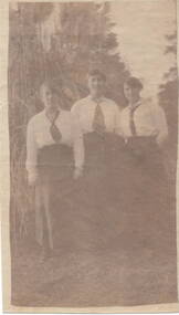
Photograph, Three ladies, c1910 - 1920
A sepia photograph with a cream border printed on very thin paper of three ladies dressed in long skirts and white long sleeved blouses with dark ties. They are standing in a valley with a hill and trees behind them. Written on the back in ink: WITH FONDEST LOVE/FROM MURIEL/I FORGOT TO PUT IT IN/MY LETTER. -
 Sunbury Family History and Heritage Society Inc.
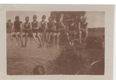
Photograph, c1920s
The swimmers were seated on the diving board over Jacksons Creek at The Nook, which served as a swimming pool in Sunbury until 1966 when the long-awaited for swimming pool was officially opened in Ligar Street on19th January 1966. For a number of years before the official opening townspeople organised many fund raising events to pay for the new pool. The pool at The Nook served as a popular swimming place for many years in Sunbury during the summer weather.A sepia photograph with a white border of a group of eight swimmers sitting on a diving board over a river. swimming, the nook, swimming clubs -
 Sunbury Family History and Heritage Society Inc.
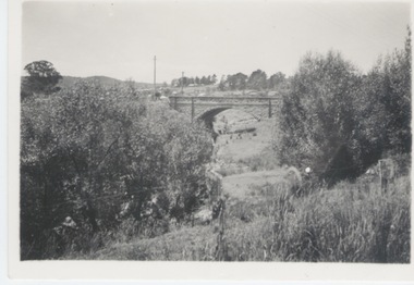
Photograph
The single span bluestone bridge is on the Calder Highway at the base of Corkscrew Hill between Gap Road and the town of Gisborne. In the early 1990s the highway was widened and dual carriageways constructed, as a result the traffic no longer travelled along the winding Corkscrew Hill road. The bridge still stands between the two carriageways. A black and white photograph with a cream border of a single arched stone bridge spanning a watercourse. Small bushes are growing in the foreground and there are some buildings dotted across the hill in the middle distance.bridges, corkscrew hill, calder highway -
 Stawell Historical Society Inc
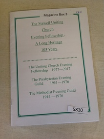
Book, The Stawell Uniting Church Evening Fellowship - A Long Heritage 103 Years, 1999
History of the Evening fellowship of the ChurchesWhite card cover with double green border and Green text inside border.Underlined Text:. The Stawell Uniting Church Evening Fellowship - A Long Heritage 103 Years. (Divide) (Text Not Underlined) The Uniting Church Evening Fellowship 1977-2017 The Presbyterian Evening Guild 1951-1976 The Metodist Evening Guild 1914 -1976stawell religion -
 Brighton Historical Society
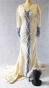
Dress, Wedding dress, 1938
This wedding dress and headpiece were worn by Emily Elizabeth (Betty) Cock (1907-2001) when she married Euston Murray Nutchey at St Andrew's Church, Brighton, on 28 April 1938. The bride's great-grandmother, Emily Cock (nee Smith), was married in the same church 69 years earlier; Emily's dress is also in the Brighton Historical Society collection. The dress was made by Melbourne dressmaker Beatrice Cook, with distinctive blue beaded panels worked by Betty's younger sister Margaret (1915-2006) to match the wedding's blue-and-pink colour scheme. The dress was accessorised with a pale blue tulle veil and a bouquet of blue hydrangeas, delphiniums and pale pink roses.Satin dress cut on the bias, originally ice-blue, now faded to cream. The dress features a long train and broad v-neck. The bodice and waist are softly ruched and gathered on either side of a finely beaded centre panel running from the neckline to the hem. The beadwork features a design of small cream-coloured leaves winding between large stylised blue flowers and leaves, all bordered with silver beads. Full-length sleeves are slightly puffed at the shoulder, narrowing to a close fit, with beaded cuffs matching the centre panel. The dress is accompanied by a matching blue, cream and silver beaded coronet or headpiece; this was originally worn with a pale blue tulle bridal veil.Label, woven mauve on beige silk, centre back: Beatrice Cookbetty cock, betty nutchey, emily elizabeth cock, emily elizabeth nutchey, euston murray nutchey, beatrice cook, wedding dress, st andrew's church brighton, 1930s, frances margaret cock, frances margaret ward -
 Brighton Historical Society
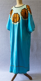
Dress
This dress belonged to Brighton woman Mariam Issa, an author, public speaker and co-founder with Katharina Kons of the nonprofit organisation Resilient Aspiring Women (RAW). Born in Somalia, Mariam and her family arrived in Australia as refugees in 1998. Seeking to bring women together and foster connections, in 2012 Mariam opened her Brighton backyard to the community. The RAW community garden unites women from all cultures through gardening, food and storytelling.Long loose kaftan-style dress, turquoise cotton with black, brown and cream embroidery around neck and shoulders, depicting large brown flowers surrounded by swirling cream border. Round neck and short, loose sleeves.mariam issa, migration, somalia, resilient aspiring women -
 Brighton Historical Society
Dress, Evening dress, 1970s
This item is part of the Di Reidie collection. Diane Reidie was a much loved volunteer and President of Brighton Historical Society from 1999 until 2016. Originally from New Zealand, Di and her family lived in Male Street, Brighton for many years. A vibrant and energetic person with a zest for life and a gift for bringing people together, Di was a friend to many in the Bayside community and active in local community organisations. Her tireless work as President of BHS saw her named Bayside Citizen of the Year in 2008. As a seller and collector of vintage clothing, she was passionate about fashion history; one of her many enduring contributions to BHS was her extensive work in preserving, developing and promoting the Society's costume collection. In 2018-19, Di donated more than one hundred items from her personal vintage clothing collection to the Society. The collection, which includes clothing, hats, handbags and shoes from local and international designers, is representative of Di's wide-ranging interests, colourful personality, creativity, humour and love of fashion and travel. Di purchased this dress as a vintage item. Elvie Hill (1917-2018) was a Melbourne fashion designer and a longtime Brighton resident. She established her eponymous label and became well-known for her elegant and feminine designs. She dressed some of Australia's best known women, including Lady Sonia McMahon and Dame Pattie Menzies, and was also known for her boutiques in Melbourne (the last store closed in 1991). She retired in 1999, aged 80.Long-sleeved silk chiffon evening dress with yellow/gold floral print and brown, red and black border at hem. Ruffled neckline and cuffs. Snap fastenings at cuffs and zip at back. Matching silk chiffon sash.Label, inside collar, black on white: "ELVIE HILL / OF MELBOURNE" Label inside seam: "SIZE 10 / TO FIT / Bust 80cm"di reidie, vintage clothing, melbourne designers, elvie hill, 1970s -
 Brighton Historical Society
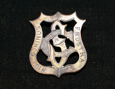
Badge, School badge, circa 1900s
This Shirley College school badge belonged to Gladys Elvira Linton, nee Richardson (b. 1891). Shirley College was a private girls' school situated in a large single-storey house in Seymour Grove, Brighton from around 1898 until 1912. The school was first run by the Misses Bird and later by Miss Elizabeth Stewart. Gladys married First World War veteran and Brighton local Richard Vivers Linton in 1919. She looked back fondly on her days at Shirley College and helped to organise school reunions well into the 1930s, long after the school itself was gone.Metal Shirley College school badge in the shape of a hollow crest containing the interlocking letters "S" and "C". The back has a hook rather than a proper clasp; possibly it was originally attached to a school hat.Motto engraved around border: "NISI DOMINUS FRUSTRA" (Latin, "without God, [it is] in vain").shirley college, schools, school uniform, 1900s, gladys elvira linton, gladys elvira richardson -
 National Wool Museum
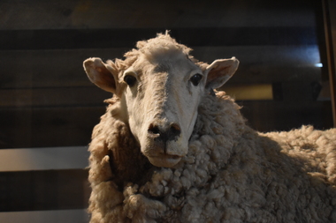
Taxidermy Sheep, Blossom, c1980
The success of any flock is through the strength of its females and Blossom, a Border Leicester/Merino Cross ewe is an excellent example. Border Leicester rams are mated with Merino ewes to produce fat lamb mothers. These first cross ewes are mated with meat sheep, such as Dorsets to produce hybrids that pass on quality wool characteristics to their offspring. The Border Leicester/Merino crosses produce good quantities of wool which, despite being of stronger micron than most Merino fleece wool (34 to 38 microns), is still in demand in the marketplace. The Border Leicester sheep takes its name from the border country between England and Scotland, the area in which the breed was first developed in the late 18th century.Border Leicester/Merino Cross ewe. Long body with white fleece. The nose is black and she has large ears, upright and alert. The head and legs are free of wool.drysdale, sheep, new zealand -
 Vision Australia
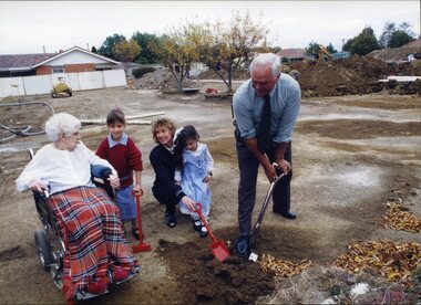
Photograph - Image, Turning the sod for the redevelopment of Kelaston, April 1, 1998
Rex Hollioake, Appeal Chairman, turns the sod for the redevelopment of Kelaston, whilst long-term resident Mary Tiernan and her family look on. A workman pulls down a fence post bordering the site for the redevelopment.7 x colour photographs of the first sod turningMary Tiernan - resident with daughter + 2 granddaughters Sara (6) and Olivia (4) Rex Hollioake - Appeal Chairman turing the sod.association for the blind, rex hollioake, mary tiernan, kelaston home (ballarat) -
 Surrey Hills Historical Society Collection
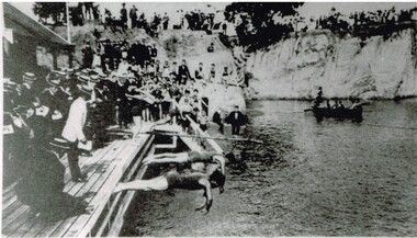
Photograph, Carnival Day at Surrey Dive, Possibly 1909
This photo records one of the swimming carnivals held at the Surrey Dive, the first of which was organised in 1907. It was at the 1907 carnival that champion swimmer Frank Beaurepaire won the one-mile championship in record time. In the era before purpose-built municipal swimming pools, Surrey Dive was a popular destination for swimming and people came to it from many Melbourne suburbs. It operated from 1905 to 1967. It was the newly formed Surrey Park Swimming Club (established in 1905) that petitioned the Box Hill Council to purchase the former quarry site associated with the Box Hill Brick Works. A ramp, bathing sheds, springboards, and eventually a 10-lane course were developed, making the Dive the first Olympic standard pool in Australia. The carnivals attracted huge crowds. The original use as a quarry explains the notorious depth of the swimming hole and the sheer, steep cliffs surrounding it. These posed obvious safety issues, as did the water quality. Ivy Lavinia Weber, who was the second woman to be elected to the Victorian parliament (the first at a general election) and renowned for her commitment to health and physical fitness, campaigned for State government assistance to build new baths. These were built adjacent to the Dive and were opened in 1939. The Dive continued as a facility used by experienced swimmers until 1967 when it closed due to the drought causing the water to dry up. Today the site has been turned into an ornamental lake. This image was used as a mural in the refurbishment of the Box Hill Aqualink. The image has strong associations with early industry (brick making), recreation and particularly the early history of the sport of swimming.Black and white photo with a white border. Scan shows image only. It shows 3 men diving from a wooden platform into an area of water beneath higher banks. There is a boat in the background, a building to the LHS of the photo and many spectators in boater hats on the platform, some in bathing suits along a ledge and many around the top of the bank. Two men in the LH foreground may be officials.Printed long the bottom edge of the frame: "An image from history - Carnival Day at the Dive. / (photo: Box Hill Council)"surrey dive, box hill brick works, swimming, surrey park swimming club, (mr) frank beaurepaire, (mrs) ivy lavinia weber, swimming carnivals -
 Beechworth RSL Sub-Branch
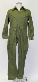
Coveralls working green, Australian Government Clothing Factory, 1985
Unknown donor, this item was typically worn by Army personnel for day to day duties at Base and workshops etcA day to day typical item of clothing worn by some Army personnel for their duties.Green cotton overalls. 410 mm shoulder width, 1143.5 mm length, 53 mm arm length-top of shoulder to arm end.,48mm waist width, 73.5mm leg length,62mm zip front from collar to waist., 39.5 mm collar with 75mm width.5mm sleeve cuff width., 45mm width for leg cuff. 16 mm zip length for all 4 pockets. Two pockets vertical from waist line-22.5 mm from middle of waist. Top two pockets with zip sloping from shoulder down towards centre of chest.Top of zip 11.5mm from shoulder with bottom of zip 23.5mm from shoulder. The pocket finishes at waist line-15mm from waist to lower zip position. Cloth hanger 7 by 25mm sewn on inside neck. Four pleats at lower back of coveralls.Green tag on neck: “A.G.C.F. VICTORIA 1985 ARROW SIGN SIZE 85-90SH 8405.66.060.4199 SERVICE NO . NAME............................ “ One other tag below first tag. The second tag is a tear off tag (7mm long ,8.5mm wide)made of light canvass off white colour with the following inscription within a 6.5mm width by 5.5mm deep 2mm black border “ THIS TAG IS FOR IDENTIFICATION ONLY PLEASE REMOVE BEFORE WEARING Docket No 44784/1 Order No 295024 34 Size. 85-90 SH Garment No 20273 Remarks. R 34 “ “ 29” At bottom right hand corner of white tag. army, geen -
 Beechworth RSL Sub-Branch
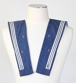
Collar, Square rig, Australian Government Clothing Factory
This style of collar has a long history in the Royal Australian Navy, descending from the uniform style of the 19th century Royal Navy.Rectangular shaped collar with three white parallel lines running the border of the collar. Collar is light navy on top and striped white and blue on interior. Collar is held in place with nine buttons on the jumper, there are nine corresponding machine-stitched button holes on the collar. Handwritten on the interior at the back of the neck and on the edge of the square collar is "D. KRUEGER" On interior label on right side, "A.G.C.F./SIZE. 3/8406.66.078.0013/R.A.N./MADE IN/AUSTRALIA"royal australian navy, uniform, marine, australian defence apparel, ratings, collar -
 Parks Victoria - Wilsons Promontory Lightstation
Telescope
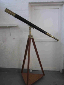
The telescope is original to the Wilsons Promontory Lightstation and was provided by the Department of Shipping and Transport in about 1900. The device magnifies images of distant objects through its curved interior mirrors, and lightkeepers used this telescope to monitor and record the names of ships, the time they passed, and their direction, as well as read meanings of flags and other visual signals communicated by vessels. The telescope is similar to Cape Nelson’s two metre long telescope, which is included in the VHR registration for the Cape Nelson Lightstation. It is particularly important for its good condition, completeness and confirmed provenance and has first level contributory significance to the cultural heritage values of the lightstation..1 Brass telescope, cylindrical tube shape with mobile interfolding sections. Middle section of tube has been covered with textile or leather and painted black. Narrow plaited rope fixed as a border to this section is also painted black. .2. The telescope is attached by a brass fitting to a wooden tripod on a three legged triangular ply wood base with three castors. -
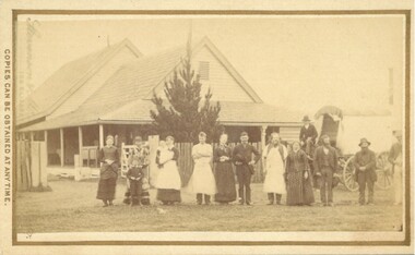 Bacchus Marsh & District Historical Society
Photograph, Cheese Factory Waddell Street Bacchus Marsh 1883
The Cheese Factory in this image was opened around 1879 by Mr. G.G. Pearce. It was in Waddell Street. It was one of the first cheese factories in Victoria. It was later owned and operated by William Telford with the assistance of John Mahon. The factory was described in the Bacchus Marsh Express newspaper as an important business and service for the region. G.G. Pearce was reported to have spent a good deal of money in setting up the factory to ensure it was one which produced high quality cheese using modern methods of production. The factory was sold in 1889 to a Mr. H. W. King who was from Abbotsford in Melbourne. Unfortunately within a few days of Mr King buying the factory it was completely destroyed in a fire. All that was left were two large pine trees and two large underground concrete tanks.G.G. Pearce was described as a pioneer of cheese factories in Victoria. His first factory was just outside of Bacchus Marsh at Hopetoun. Around 1879 he moved into Bacchus Marsh and opened a new purpose built factory in Waddell Street. The Bacchus Marsh Express newspaper reported that no expense had been spared in constructing this factory. The factory was completely destroyed in a fire in 1889 which makes it fortunate that this image was captured of this early cheese factory in Victoria.Small sepia unframed photograph on card with gold border framing photograph. Housed in the album, 'Photographs of Bacchus Marsh and District in 1883 by Stevenson and McNicoll'. The image shows a group of men and women standing in a row in front of the Bacchus Marsh Cheese factory. One of the women is holding a small child. In front of another woman stands a young boy. Behind them is a covered wagon with a man seated upon it. Some of the men and women are wearing long aprons. In the background is the Cheese Factory. It is a large wooden structure with a high and steep pitched roof.On the front: Stevenson & McNicoll. Photo. 108 Elizabeth St. Melbourne. COPIES CAN BE OBTAINED AT ANY TIME. On the back: LIGHT & TRUTH inscribed on a banner surmounted by a representation of the rising sun. Copies of this Portrait can be had at any time by sending the Name and Post Office Money Order or Stamps for the amount of order to STEVENSON & McNICOLL LATE BENSON & STEVENSON, Photographers. 108 Elizabeth Street, MELBOURNE stevenson and mcnicoll 1883 photographs of bacchus marsh and district, cheese factories, bacchus marsh cheese factory