Showing 1085 items
matching north entrance
-
 Ringwood and District Historical Society
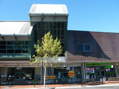
Photograph, West of entrance to Eastland, Ringwood in 2008, showing shops at Ringwood Plaza and Ringwood Library above
Photographic record by Russ Haines, RDHS, in 2008. -
 Ringwood and District Historical Society
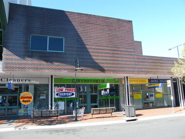
Photograph, West of entrance to Eastland, Ringwood in 2008, showing shops at Ringwood Plaza and Ringwood Library workarea above
Photographic record by Russ Haines, RDHS, in 2008. -
 Ringwood and District Historical Society
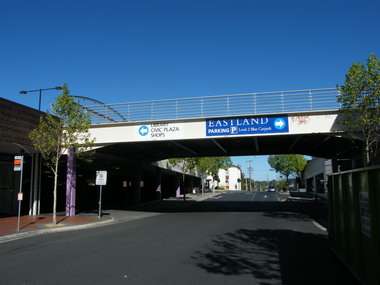
Photograph, West of entrance to Eastland, Ringwood in 2008, showing car overpass, with Ringwood Street in distance
Photographic record by Russ Haines, RDHS, in 2008. -
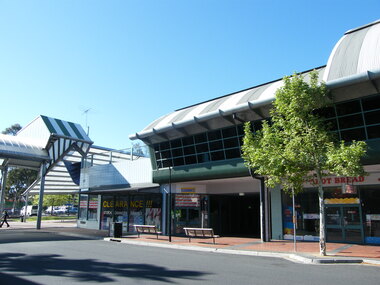
 Ringwood and District Historical Society
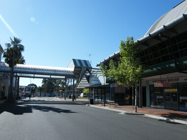
Photograph, Looking to the east to entrance to Eastland, Ringwood in 2008, showing walkway
Photographic record by Russ Haines, RDHS, in 2008. -
 Ringwood and District Historical Society
Photograph, Looking to the east to entrance to Eastland, Ringwood in 2008, showing walkway and shops
Photographic record by Russ Haines, RDHS, in 2008. -
 Ringwood and District Historical Society
Photograph, Carter real estate at 124-6 Maroondah Highway, Ringwood in 2008. Next to former station entrance
Photographic record by Russ Haines, RDHS, in October 2008. -
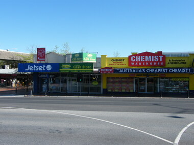 Ringwood and District Historical Society
Photograph, Shops on 151-159 Maroondah Highway, Ringwood opposite the former railway station entrance. Jetset, Cash Store and Chemist Warehouse shops
Photographic record by Russ Haines, RDHS, in October 2008. -
 Ringwood and District Historical Society
Photograph, Corner of Railway Place and Maroondah Highway, Ringwood at the former entrance to the railway station, showing shops on the other side of the road (now REALM library)
Photographic record by Russ Haines, RDHS, in October 2008. -
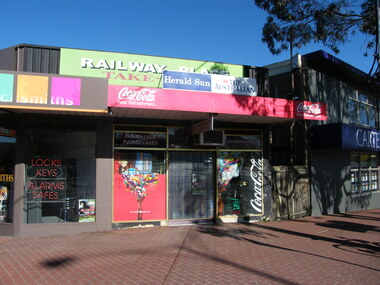 Ringwood and District Historical Society
Photograph, East end of Railway Place, Ringwood near the former entrance to the railway station, showing locksmith, cafe and Carter real estate
Photographic record by Russ Haines, RDHS, in October 2008. -
 Ringwood and District Historical Society
Photograph, Entrance to Melbourne Street, Ringwood
Photographic record by Russ Haines, RDHS, in October 2008. -
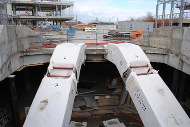 Ringwood and District Historical Society
Photograph, Probuild tour of Stage 5 building of Eastland, Ringwood in 2015. Showing new escalators at entrance to new Eastland. The REALM library being built on left. Railway Station and offices in background
Photographs taken by Jeff Leipold, member of RDHS -
 Ringwood and District Historical Society
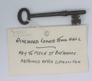
Memorabilia - Key, Key with tag attached - "Ringwood Lower Town Hall - Key to Melbourne Street Entrance - obtained after demolition". (1927-1971), 1927
Key to the lower Town Hall, Ringwood. It is the key to the Melbourne Street entrance obtained after demolition of the town hall in 1971. It had been built in 1927.Metal key - brown coloured with loop top, long shank and crenelated lock part.'4' -
 Ringwood and District Historical Society
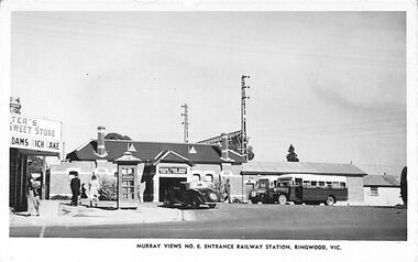
Photograph/Postcard, Postcard and souvenir photograph - Murray Views No.6 Entrance Railway Station, Ringwood, Vic. Circa 1948
Black and white "Murray Views" postcard and souvenir photograph - 1948 handwritten on back. 1948 handwritten on back. Postcard - Real Photograph Produced in Australia by Murray Views, Gympie, Q. -
 Ringwood and District Historical Society
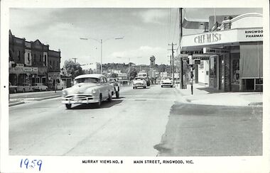
Photograph/Postcard, Postcard - Murray Views No.8 - Main Street, Ringwood, Vic
Black and white "Murray Views" postcard - Eastward view from Railway Station Entrance along Maroondah Highway, Ringwood. Clocktower on Warrandyte Road corner. Circa early 1960s.1959 handwritten on front and back is incorrect - Early 1960s model cars in view. -
 Ringwood and District Historical Society
Photograph, 29th October 1989 – Our Ladies Church – new Wilana Street entrance, 1989
Digital photograph -
 Ringwood and District Historical Society
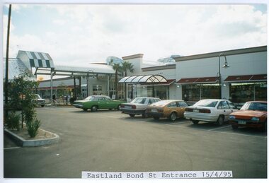
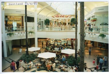
photograph, Eastlink Ringwood Bypass Construction-Eastland Bond St Entrance 15/4/95
Colour photographWritten on back of photo: "Bottom End of Eastland 15/4/95" -
 Ringwood and District Historical Society
photograph, Eastlink Ringwood Bypass Construction-Eastland 15/4/95
Colour photographWritten on back of photo: "Eastland-Bond St Entrance 15/4/95" -
 Ringwood and District Historical Society
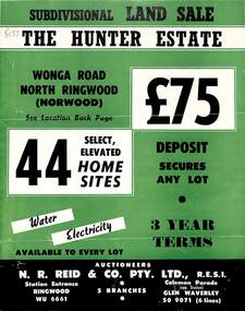
Flyer, Land Sale Brochure, The Hunter Estate, North Ringwood, Vic. - circa 1960
Bi-fold land sale advertisement for The Hunter Estate, North Ringwood, including terms of sale, area map, layout of the estate, and summary of local facilities and services, with separate attachment listing lot number prices.Subdivision includes Wonga Road, Hunter Avenue (later Graeme Avenue), Panfield Avenue, Hendra Grove, and Mullum Mullum Road. Agent - N.R. Reid & Co. Pty. Ltd., Station Entrance, Ringwood. (Phone) WU 6661. -
 Ringwood and District Historical Society
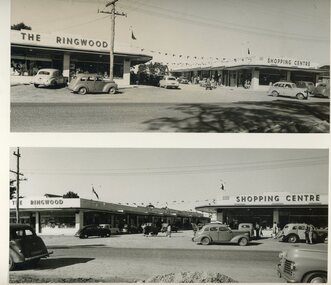
Photographs / Album, Richard Stewart - Photographer, Official opening of the Ringwood Shopping Centre by Sir John Allison - 6th July 1954
Black and white photograph - View of front entrance Ringwood Shopping Centre -86 Whitehorse Road -
 Ringwood and District Historical Society
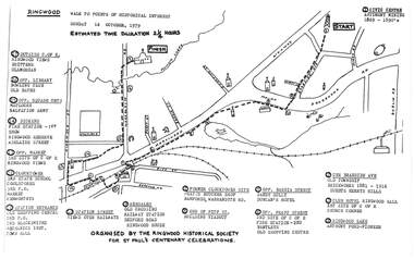
Pamphlet, Ringwood Walk - Points of Historical Interest, 1979
Sketch of walking route for 17 historical points of interest organised by the Ringwood Historical Society for St. Paul's Church Centenary Celebrations - 14 October 1979, estimated duration 2-1/4hours.1 - Start 2 - Cnr Braeside Avenue, old township, brickworks 1881-1916, Guests, Herrys, Hills 3 - Club Hotel, Ringwood Hall, 1st site of C of E church corner 4 - Ringwood Lake, Anthony Ford - pioneer 5 - Opposite Bardia Street, Sandy Gully, Duncan's Hotel 6 - Opposite Pratt Street, 2nd site of C of E, 2nd fire station, Bentleys, old shopping centre 7 - Warrandyte Road, Former Clocktower site, Pratts butcher shop, Bamfords 8 - End of Pitt Street, building viaduct 9 - Bedford Road, Webdales, old crossing, railway station 10 - Station Street, views over railways 11 - Station entrance, old shopping centre, 2nd Postoffice, 2nd blacksmiths, Mechanics Institute, Town Hall 12 - Clocktower, 3rd State School, coolstores, 3rd Postoffice, market, Kenworthys 13 - Opposite market, 3rd site of C of E, Ringwood views 14 - Adelaide Street, Dickens, 1st fire station, Ringwood Reserve 15 - Opposite squash courts, Matlocks, Salvation Army 16 - Opposite library, bowling club, old baths 17 - Outside C of E, Ringwood views, Brittens, Glamorgan -
 Ringwood and District Historical Society
Photographs, North Ringwood Elderly Citizens Building, 1992
... Road Ringwood North melbourne 11060A: 28.11.92 Entrance to N ...2 B&W photographs taken by Ringwood Historical Research Group: 11060A: 28.11.92 Entrance to N. Ringwood Elderly Cits 11060B: 28.11.92 N. Ringwood Elderly Cits Tea Servery -
 Ringwood and District Historical Society
Photograph, Ringwood Railway Station before development- circa 2000
Coloured photograph"Written on back of photograph" Ringwood station before development. Front Entrance -
 Kiewa Valley Historical Society
Folder - Kiewa Methodist Church, 1917 to 1962
The copy of a letter written by Harry H. Simmonds of Huon notes that "the church existed in 1905. It was built by Hill and McCormack with timber donated by Mr Ned Dunstan on ground donated by Mr James Thomas probably in the late 1800s. It was possibly called a Methodist Church because the donor of the land was a Methodist. It was used by the three Protestant Groups and maintenance was paid for by an annual area collection.The house on the west side was a Presbyterian Manse for many years and the block of ground on the north side was known as the Manse paddock in which the minister grazed his cow and horse." In 1936 there was a fence between the Kiewa Methodist Church was the Presbyterian Church in Kiewa. Its Certificate of Title is Volume 5134 Folio 1026783 (Sept. 1942.) In 1952, the church was made of wood with an iron roof. In 1954. Request to Yackandandah Shire re a fence from Kiewa Consolidated School entrance to the unused hedge adjacent to the Church. In 1958 there was correspondence re 'the strip of land on each side of the Church.' Churches were an important part of life during the late 19th century and early to mid 20th century and were built in the centre of town as was this one. These papers give an understanding of the work involved in maintaining a church. The letters and 'book' give a lot of names of local families involved with the Methodist Church at Kiewa. Yellow plastic spiral folder with 18 pages enclosed in clear plastic sleeves.Papers enclosed include accounts, payments, tenders and other correspondence relating to the Methodist Church at Kiewa dating from 1932 to 1962. Of particular interest is a black cardboard cover book dated 1917 re collection of donations from listed people. The latest date in the book is 1942.Enclosed in first plastic sleeve is a letter from the donor, Kathie Vines dated 15th July 2013methodist church; kiewa; harry h. simmonds; yackandandah council; -
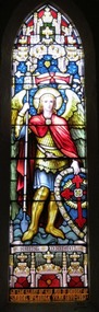 Christ Church Anglican Parish of Warrnambool
Memorial Window: Rev Canon Samuel McGEORGE, St. Michael
Samuel McGeorge was born in Belfast, Ireland in 1850. He was trained for the ministry at Moore College, Sydney. He was Vicar in Ararat for 10 years prior to coming to Warrnambool in 1899, to become the 3rd Vicar of the Parish. He was inducted on June 1st by Bishop Cooper. He showed a deep regard for the welfare and happiness of his parishioners. Christ Church progressed well under his charge. He suffered a very painful and distressing illness which forced him to obtain leave of absence from his clerical duties, but he continued to visit and encourage the sick and sorrowing. On December 4th 1904, Canon McGeorge opened the new Church and Sunday School in Koroit St, East Warrnambool, of which he had established. It was opened as a Mission Hall. It was to become St. George's and the first recorded service was on February 11th 1906. He preached his last sermon at Christ Church on Dec 4th before illness prevented him performing his duties. He resigned from the Vicariate shortly before his death in Warrnambool on December 16th, 1905. The stained glass window in the north wall of the second nave was a gift of many parishioners. Depicting St. Michael, it was erected in memory of Rev Canon McGeorge, and was unveiled by Dean Parkyn on December 23rd, 1906. His widow Mrs Emma McGeorge, remained an active church worker until her death in 1933. The Lych gate at the Koroit Street entrance was built with a bequest from her.Stained glass lancet window, north wall, north nave, depicting Saint Michael, the arch-angel Michael.Saint Michael. To the Glory of God and in memory of/ Samuel McGeorge Vicar 1899 - 1903 -
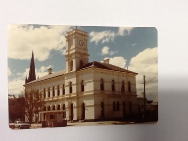 Port of Echuca
Colour photograph, Approx. 1979
... -storey stucco building with a clock tower over the entrance... stucco building with a clock tower over the entrance ...The old Echuca Post Office was built circa 1877, a two-storey stucco building with a clock tower over the entrance, on the north east corner of Hare and Anstruther streets. In the front of the building is a small cream brick kiosk used as a bus stop and as a stall for charity group's to sell produce. On the far northern corner the spire of St.Mary's church can be seen above the roof of the Post Office.The old Echuca Post office is at the northern end of the shopping precinct in Hare street Echuca. The building is a beautiful grand building of the late 1870's which was built as a post office on the ground floor and a residence above. The small kiosk building in front of the post office was used by volunteer organisations to raise money selling cakes etc. at various times of the year.Colour photograph (post card size) of Echuca Post Office looking north. The post office was built circa 1877, a two storey building with a clock tower over the entrance door. In front of the building is a small cream brick kiosk and bus shelter.Printed on the reverse "this paper manufactured by Kodak"echuca post office, echuca-historical buildings -
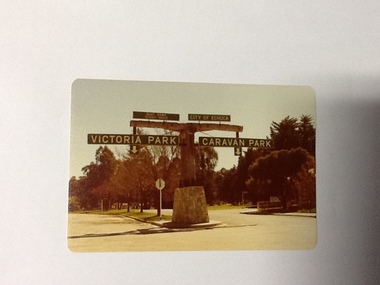 Port of Echuca
Colour Photograph, Approx.1979
In 1869 the Council moved to name this park "Victoria Park. The cricket pitch construction began in 1873 and major improvements to the ground were undertaken in 1881. It is still the primary sporting ground in Echuca, offering AFL football oval, cricket pitch and nets, athletics and entry to the Echuca boat ramp and the natural bush land of the scenic drive. It also houses Echuca Council caravan park. The signage in this photograph is no longer there and the enterance to the caravan park has moved.This area of Echuca has historically been a major recreational area for the town. Being the primary sporting ground since its establishment in 1869., the area has a number of sporting and recreational facilities for the people of Campaspe Shire, from natural bush walks in and along the Murray river to more formal facilities such as AFL football ground, firefighting training area, netball courts, cricket pitch and nets, and grass tennis courts. Colour photograph (post-card size) of directory signs to entrance of Victoria Park, Echuca taken facing north. Two driveways are shown, to the east "Caravan Park" and to the west , "Victoria Park", "Boat ramp", " Scenic drive"Printed in black on the reverse:"this paper manufactured by Kodak"echuca, port of, echuca council caravan park, victoria park, echuca, echuca-tourist attraction -
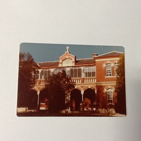 Port of Echuca
Colour Photograph, Approx. 1979
Formerly the home of Henry Hopwood. Apsley House, No. 1 Echuca. This was purchased for the Bridgine nuns to establish a catholic co-education school in Echuca. Extensions were made to the original structure (to the south of this building) with outbuildings and brick stables converted to school rooms during the late 1886 and opened as St Joseph's in 1887. The front section of the school was built in 1888. At the time of this photograph the upper floor of the building was the boarding house. The school building holds historical, social and spiritual significance to Echuca being the former home of Echuca's founder, Henry Hopwood. The diocese purchased the original building for 1,000 pounds. The school opened as a co-educational school on 22/3/1886 with 16 boys and 7 girls. It's first enrolment was a non-Catholic boy. By the end of 1886 there were 30 pupils. The boarding school opened on 4/5/1886 with 6 students. The chapel (to the north of this building) was built in 1889. For 60 years the school provided both primary and secondary schooling but in 1960's it changed to secondary schooling. The boarding house closed around 1986 and the school continued as a co-educational catholic college.Colour photograph (post-card size) of Bridgine Convent, Echuca (St.Joseph's College), showing arched facade over the verandah and the upper louvred windows of the boarding house.On front above the entrance "Brigidine Convent A.D. 1886.. Printed on the reverse:" this paper manufactured by Kodak"echuca- secondary schools, st joseph's college, echuca, brigidine convent, echuca -
 Eltham District Historical Society Inc
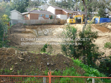
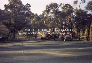
Photograph, Daryl Morrow, Redevelopment of former site of Hassall's Roadside Gallery, Main Road, Eltham, 10 July 2023
This historic site of Australia’s first open-air gallery is being redeveloped in 2023 for multi-housing fronting the Research Creek. In 1955, Ian and Joan Hassall moved to Eltham. They took a property on the corner of Zig Zag Road and Main Road, Eltham, north of the township (later known as 1215 Main Road). In July 1962, they opened their open-air gallery. Hassall’s Roadside Galley, “…cradled in the fold of hills to the north of Eltham” inspired by Ian’s own experience of exhibitions along the Embankment in London. The property included remnants of a stone quarry, paintings were hung on screens and removed at night. Various pedestals, that looked like giant mushrooms displayed sculpture, pottery, and jewellery. It had a small natural amphitheatre at the foot of a little sandstone cliff that fall away to the bed of a stream. To enter the gallery, a visitor crossed a small freestone bridge of oriental design, built by Hassall from local stone. The bridge spanned the stream flowing beneath great willow trees. Near the entrance wooden figures were displayed formed from pieces of local wood, said to speak to Ian Hassall’s sense of fun. Hassall’s Gallery was the first gallery of its kind in Australia. Ian became a full-time artist and when it first opened, he exhibited paintings he had made while touring the outback with writer and fellow Eltham resident Alan Marshall. He also exhibited other Australian artists over time including locals Lindsay Edward and Peter Glass.daryl morrow collection, eltham heights luxury living, hassalls roadside gallery, housing development, real estate development, research creek, 2023-07-10 -
 Eltham District Historical Society Inc
Photograph, Daryl Morrow, Redevelopment of former site of Hassall's Roadside Gallery, Main Road, Eltham, 13 July 2023
This historic site of Australia’s first open-air gallery is being redeveloped in 2023 for multi-housing fronting the Research Creek. In 1955, Ian and Joan Hassall moved to Eltham. They took a property on the corner of Zig Zag Road and Main Road, Eltham, north of the township (later known as 1215 Main Road). In July 1962, they opened their open-air gallery. Hassall’s Roadside Galley, “…cradled in the fold of hills to the north of Eltham” inspired by Ian’s own experience of exhibitions along the Embankment in London. The property included remnants of a stone quarry, paintings were hung on screens and removed at night. Various pedestals, that looked like giant mushrooms displayed sculpture, pottery, and jewellery. It had a small natural amphitheatre at the foot of a little sandstone cliff that fall away to the bed of a stream. To enter the gallery, a visitor crossed a small freestone bridge of oriental design, built by Hassall from local stone. The bridge spanned the stream flowing beneath great willow trees. Near the entrance wooden figures were displayed formed from pieces of local wood, said to speak to Ian Hassall’s sense of fun. Hassall’s Gallery was the first gallery of its kind in Australia. Ian became a full-time artist and when it first opened, he exhibited paintings he had made while touring the outback with writer and fellow Eltham resident Alan Marshall. He also exhibited other Australian artists over time including locals Lindsay Edward and Peter Glass.daryl morrow collection, eltham heights luxury living, hassalls roadside gallery, housing development, real estate development, research creek, 2023-07-13 -
 Eltham District Historical Society Inc
Photograph (Item) - Negative, Jocelyn Zepter-Trevor, Entrance to the Eltham Barrel, Main Road, Eltham, 1988
Jocelyn Zepter-Trevor 1988 Entrant No. 69 Ref: Series 34, Item 24 The images in this record were not selected for inclusion. SHIRE OF ELTHAM COMMUNITY PHOTOGRAPHIC SURVEY Photography is an artform which many of us practice, sometimes purely for artistic pursuit, sometimes to record the people and events in our lives. In 1988, as part of a local Bicentennial project, the Shire of Eltham conducted the Eltham Community Photographic Survey. Up to 100 entries were to be selected by a panel of photographers for entry into the Eltham Photographic Survey Exhibition. Entries had to be submitted by May 13, 1988. Entrants whose images were selected for the exhibition were contacted and requested to further submit an entry form providing entrant’s name, area of residence, age, and proposed captions. These details were then used to produce labels for the exhibition mounts. Where negatives had not been supplied, these were requested to support the display of printed enlargements mounted on 10” x 8” cardboard. The mounted prints were made available post exhibition for sale at $8.50 each for colour prints and $7.00 for B&W prints. Residents in the Shire were invited to collect a free roll of film and take a photograph of what they either liked or did not like about the area. A total of 160 entrants submitted multiple entries for the exhibition. Of those selected for exhibition, entrants ranged in age from 9 to 70 years. All custom colour and black and white printing for the exhibition was completed by Wattle Studios of Eltham. The Eltham Photographic Survey was jointly auspiced by the Shire of Eltham and Wattle Studios, of 953 Main Road, Eltham. The project was greatly assisted by: • David McRitchie, Media Studies Lecturer Victoria College, Rusden Campus. • Ian and Annette Toohill of Wattle Studios • Tracy Naughton, Eltham Community Arts Officer • Neville Emerson Pty. Ltd. • Superior Press, Eltham • Kodak Australasia Pty. Ltd. • Agfa Gevaert Ltd. • Townsend Colourtech Pty. Ltd. • The Australian Bicentennial Authority • Eleanor Bowers, Secretary, Eltham Arts Council The exhibition was placed on display in the Woolworths Arcade, Eltham between Monday June 6th and Saturday June 11, 1988. It was also intended to hold the exhibition at a venue in the Shire’s North Riding from Monday, June 20 to Friday June 24. It was then displayed at the Were Street Theatre, Montmorency from Friday, June 24 to Thursday, July 7. Series 34: Eltham Community Photographic Survey 1988 - Prints & Documentation Series consists of 117 photographs of Shire scenes taken by members of the community. Items I - 41 are larger photographs mounted on card, which were exhibited. Items 42 - 117 are unmounted copies, alternative takes and other entries. Corresponding negatives contained in Series 35: Eltham Community Photographic Survey 1988 – Negatives which consists of 267 colour and B&W negatives and one colour slide of Shire scenes taken by members of the community. The negatives are arranged by the entrant number of the photographer. The Eltham Community Photographic Survey collection is significant to the local community as it was curated by the local community - ordinary people of all ages - representing what they liked and did not like in the area where they lived. It represents an unfiltered representation of the Shire of Eltham as it was in 1988. It also represents one of many projects as part of the national programme of events and celebrations to commemorate the bicentenary. It is a time capsule of life in the 1980s of this urban and rural municipality in Melbourne's north. shire of eltham archives, bicentennial project, eltham, eltham community photographic survey, film - agfa xr 100 i, jocelyn zepter-trevor, scan - 35mm negative, series 35, eltham barrel, main road, maple leaf band