Showing 236 items
matching opposed
-
 Eltham District Historical Society Inc
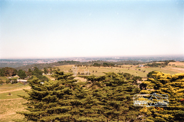
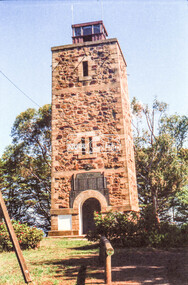
Photograph, View from the Shire of Eltham War Memorial Tower, Memorial Park, Garden Hill, Eltham-Yarra Glen Road, Kangaroo Ground, 8 July 1994, 08/07/1994
On November 11th 1926 the Shire of Eltham War Memorial Tower at Kangaroo Ground was opened. It is regarded as one of Melbourne’s most outstanding lookout towers. It commands a magnificent 360 degree panorama from Kinglake across the Diamond Valley to Macedon and the You Yangs. It is built on a peak which was once a volcano, 237 metres above sea level. After World War one a memorial cairn was erected on the site, and in 1925 a committee of public-minded citizens began to plan for a tower. Many generous donations of material and money were forthcoming so that in 1926 the Governor General Lord Stonehaven was able to unveil the plaque before a crowd of 500 people There was some concern in the 1960s when the Forests Commission wanted to build a firespotters cabin on the top. At first R.S.L. branches opposed the idea, but it was realised that this use could combine with its use as a tourist attraction, and would ensure its maintenance for the future. Today the Kangaroo Ground tower provides one of the best views around Melbourne and is a fitting memorial to those who died in two world wars. From: Historic items for Diamond Valley Community Radio September 1990 (EDHS collection) On November 8th, 1951, the memorial was re-dedicated by the Governor of Victoria, Sir Dallas Brooks with the addition of the names of men from the Shire of Eltham who fell in the Second World War. Further wreaths were added subsequent to this image in time for the 2001 Reembrance Day service to commemorate the men from th shire who had fallen in the Malayan, Korean, Borneo and Vietnam campaigns.Roll of 35mm colour negative film, 4 stripsFuji 100garden hill, kangaroo ground, kangaroo ground memorial, memorial park, shire of eltham war memorial tower, war memorial -
 Eltham District Historical Society Inc
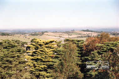
Photograph, View from the Shire of Eltham War Memorial Tower, Memorial Park, Garden Hill, Eltham-Yarra Glen Road, Kangaroo Ground, 8 July 1994, 08/07/1994
On November 11th 1926 the Shire of Eltham War Memorial Tower at Kangaroo Ground was opened. It is regarded as one of Melbourne’s most outstanding lookout towers. It commands a magnificent 360 degree panorama from Kinglake across the Diamond Valley to Macedon and the You Yangs. It is built on a peak which was once a volcano, 237 metres above sea level. After World War one a memorial cairn was erected on the site, and in 1925 a committee of public-minded citizens began to plan for a tower. Many generous donations of material and money were forthcoming so that in 1926 the Governor General Lord Stonehaven was able to unveil the plaque before a crowd of 500 people There was some concern in the 1960s when the Forests Commission wanted to build a firespotters cabin on the top. At first R.S.L. branches opposed the idea, but it was realised that this use could combine with its use as a tourist attraction, and would ensure its maintenance for the future. Today the Kangaroo Ground tower provides one of the best views around Melbourne and is a fitting memorial to those who died in two world wars. From: Historic items for Diamond Valley Community Radio September 1990 (EDHS collection) On November 8th, 1951, the memorial was re-dedicated by the Governor of Victoria, Sir Dallas Brooks with the addition of the names of men from the Shire of Eltham who fell in the Second World War. Further wreaths were added subsequent to this image in time for the 2001 Reembrance Day service to commemorate the men from th shire who had fallen in the Malayan, Korean, Borneo and Vietnam campaigns.Roll of 35mm colour negative film, 4 stripsFuji 100garden hill, kangaroo ground, kangaroo ground memorial, memorial park, shire of eltham war memorial tower, war memorial -
 Federation University Art Collection
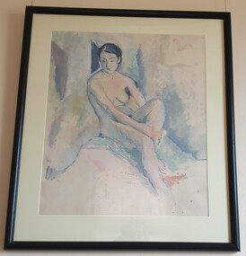
Painting - Oil on paper, William Frater, 'Nude' by William Frater, 1932
William FRATER (1890-1974) Born 31 January 1890 at Ochiltree Castle, near Linlithgow, Scotland Arrived Melbourne, Australia in September 1910 In a lecture on modern art in 1925, Frater stated the basic position from which the rest of his oeuvre stems: 'Copying nature is not an art; … to copy effects of light tends to destroy form and colour'. Frater gave aggressive leadership to the small group of modernists in the 1920s. His example, teaching, lecturing and crusty style of polemic did much to disrupt the academic style as the arbiter of pictorial values and to pioneer a change of taste in the community.His approach in the 1930s was markedly indebted to Cézanne, especially in the portraits which predominated until his retirement from stained-glass designing in 1940. (L. J. Course, 'Frater, William (1890–1974)', Australian Dictionary of Biography, National Centre of Biography, Australian National University, http://adb.anu.edu.au/biography/frater-william-6239/text10739, published first in hard copy 1981, accessed online 3 May 2016.) Jock Frater was on of the first modern painters who opposed the fashionable and academic schools of painting. During the 1930s he exhibited with the Contemporary Art Group along with Arnold Shore and George Bell. During a very conservative period in Australian Art John Frater advanced the cause of innovation and modernism. This item is part of the Federation University Art Collection. The Art Collection features over 2000 works and was listed as a 'Ballarat Treasure' in 2007.Framed seated nude study in oil on paper. Lower centre in pencil "W. Frater". In lighter pencil "painted 1932"art, artwork, frater, william frater, life drawing, nude, oil on paper, portrait, jock frater, william jock frater, available -
 Eltham District Historical Society Inc
Negative - Photograph, Russell Yeoman, Shire of Eltham War Memorial, Memorial Park, Garden Hill, Eltham-Yarra Glen Road, Kangaroo Ground, c.1980
Shire of Eltham War Memorial Tower at Kangarooo Ground; view from the east and close up of entrance including Honour Roll. On November 11th 1926 the Shire of Eltham War Memorial Tower at Kangaroo Ground was opened. It is regarded as one of Melbourne’s most outstanding lookout towers. It commands a magnificent 360 degree panorama from Kinglake across the Diamond Valley to Macedon and the You Yangs. It is built on a peak which was once a volcano, 237 metres above sea level. After World War one a memorial cairn was erected on the site, and in 1925 a committee of public-minded citizens began to plan for a tower. Many generous donations of material and money were forthcoming so that in 1926 the Governor General Lord Stonehaven was able to unveil the plaque before a crowd of 500 people There was some concern in the 1960s when the Forests Commission wanted to build a firespotters cabin on the top. At first R.S.L. branches opposed the idea, but it was realised that this use could combine with its use as a tourist attraction, and would ensure its maintenance for the future. Today the Kangaroo Ground tower provides one of the best views around Melbourne and is a fitting memorial to those who died in two world wars. From: Historic items for Diamond Valley Community Radio September 1990 (EDHS collection) On November 8th, 1951, the memorial was re-dedicated by the Governor of Victoria, Sir Dallas Brooks with the addition of the names of men from the Shire of Eltham who fell in the Second World War. Further wreaths were added subsequent to this image in time for the 2001 Reembrance Day service to commemorate the men from th shire who had fallen in the Malayan, Korean, Borneo and Vietnam campaigns.Roll of 35mm colour negative film, 2 strips Kodak Safety 5035 Colour print (x1)Kodak Safety 5035garden hill, kangaroo ground, kangaroo ground memorial, memorial park, shire of eltham war memorial, shire of eltham war memorial tower, war memorial, kangaroo ground relief committee -
 Eltham District Historical Society Inc
Negative - Photograph, Russell Yeoman, Shire of Eltham War Memorial, Memorial Park, Garden Hill, Eltham-Yarra Glen Road, Kangaroo Ground, c.1980
Shire of Eltham War Memorial Tower at Kangarooo Ground; view from the east and close up of entrance including Honour Roll. On November 11th 1926 the Shire of Eltham War Memorial Tower at Kangaroo Ground was opened. It is regarded as one of Melbourne’s most outstanding lookout towers. It commands a magnificent 360 degree panorama from Kinglake across the Diamond Valley to Macedon and the You Yangs. It is built on a peak which was once a volcano, 237 metres above sea level. After World War one a memorial cairn was erected on the site, and in 1925 a committee of public-minded citizens began to plan for a tower. Many generous donations of material and money were forthcoming so that in 1926 the Governor General Lord Stonehaven was able to unveil the plaque before a crowd of 500 people There was some concern in the 1960s when the Forests Commission wanted to build a firespotters cabin on the top. At first R.S.L. branches opposed the idea, but it was realised that this use could combine with its use as a tourist attraction, and would ensure its maintenance for the future. Today the Kangaroo Ground tower provides one of the best views around Melbourne and is a fitting memorial to those who died in two world wars. From: Historic items for Diamond Valley Community Radio September 1990 (EDHS collection) On November 8th, 1951, the memorial was re-dedicated by the Governor of Victoria, Sir Dallas Brooks with the addition of the names of men from the Shire of Eltham who fell in the Second World War. Further wreaths were added subsequent to this image in time for the 2001 Reembrance Day service to commemorate the men from th shire who had fallen in the Malayan, Korean, Borneo and Vietnam campaigns.Roll of 35mm colour negative film, 2 strips Colour print (x1)Kodak Safety 5035garden hill, kangaroo ground, kangaroo ground memorial, memorial park, shire of eltham war memorial tower, war memorial, garden hill, kangaroo ground, kangaroo ground memorial, kangaroo ground relief committee, memorial park, shire of eltham war memorial tower, war memorial, shire of eltham war memorial -
 Eltham District Historical Society Inc
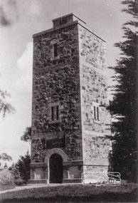
Photograph, Shire of Eltham War Memorial, Memorial Park, Garden Hill, Eltham-Yarra Glen Road, Kangaroo Ground, c.1936
Showing front angle view of tower and old fire watchbox on top On November 11th 1926 the Shire of Eltham War Memorial Tower at Kangaroo Ground was opened. It is regarded as one of Melbourne’s most outstanding lookout towers. It commands a magnificent 360 degree panorama from Kinglake across the Diamond Valley to Macedon and the You Yangs. It is built on a peak which was once a volcano, 237 metres above sea level. After World War one a memorial cairn was erected on the site, and in 1925 a committee of public-minded citizens began to plan for a tower. Many generous donations of material and money were forthcoming so that in 1926 the Governor General Lord Stonehaven was able to unveil the plaque before a crowd of 500 people There was some concern in the 1960s when the Forests Commission wanted to build a firespotters cabin on the top. At first R.S.L. branches opposed the idea, but it was realised that this use could combine with its use as a tourist attraction, and would ensure its maintenance for the future. Today the Kangaroo Ground tower provides one of the best views around Melbourne and is a fitting memorial to those who died in two world wars. From: Historic items for Diamond Valley Community Radio September 1990 (EDHS collection) On November 8th, 1951, the memorial was re-dedicated by the Governor of Victoria, Sir Dallas Brooks with the addition of the names of men from the Shire of Eltham who fell in the Second World War. Further wreaths were added subsequent to this image in time for the 2001 Reembrance Day service to commemorate the men from th shire who had fallen in the Malayan, Korean, Borneo and Vietnam campaigns.Black and white photograph showing front angle view of tower and old watchbox on topgarden hill, kangaroo ground, kangaroo ground memorial, memorial park, shire of eltham war memorial tower, war memorial -
 Eltham District Historical Society Inc
Negative - Photograph, Eltham War Memorial Obelisk 1914-1918, cnr. Main Road and Bridge Street, c.1925
Located on what was referred to as Obelisk Corner, improvements have been been made since the unveiling in August 1919 with the provision of a stone retaining wall topped with a chain link and granite stone boundary, most likely in conjunction with improvements to the intersection into Main Road. Along with the use of the name Obelisk Corner, the Bridge Street bridge was also known as Obelisk Bridge. The Eltham Obelisk was originally located at the corner of Bridge and Main Roads in 1919. In 1943 (WW2) the local community commenced plans to establish the Eltham War Memorial, a living memorial to benefit the children as opposed to a one in stone as per the obelisk. The Eltham War Memorial Trust was established in 1945. In 1947 the Trust intended for the Obelisk to be relocated from Bridge Street and Main Road to the Garden of Remembrance which was planned as part of the Baby Health Centre which was to be the first of three buildings of the Eltham War Memorial to be built in 1951. In 1951 the Eltham RSL was invited to be represented on the Eltham War Memorial Trust. Around this time, with pending roadworks, the obelisk was relocated to the front garden of the Eltham RSL sub branch on Main Road for safe keeping. In 2007, a suggestion was proposed by Harry Gilham (President, EDHS) to John Cohen (ERSL) to claim a special site along with the historic Shillinglaw trees on the now vacant former Eltham Shire Office site adjacent to the Eltham War Memorial precinct for relocation of the obelisk. In 2010 following the financial collapse and sale of the Eltham RSL Sub-Branch property and amalgamation with the Montmorency Eltham RSL sub-branch, the location of the obelisk was again in immediate jepoardy and in conjunction with Nillumbik Shire Council, the obelisk was relocated in front of the Eltham War Memorial buildings in preparation for the Dawn Service on Anzac Day 2012.This photo forms part of a collection of photographs gathered by the Shire of Eltham for their centenary project book,"Pioneers and Painters: 100 years of the Shire of Eltham" by Alan Marshall (1971). The collection of over 500 images is held in partnership between Eltham District Historical Society and Yarra Plenty Regional Library (Eltham Library) and is now formally known as the 'The Shire of Eltham Pioneers Photograph Collection.' It is significant in being the first community sourced collection representing the places and people of the Shire's first one hundred years.Digital image 4 x 5 inch B&W Negsepp, shire of eltham pioneers photograph collection, eltham, main road, eltham war memorial, bridge street, obelisk, obelisk corner -
 Eltham District Historical Society Inc
Photograph, Eltham War Memorial 1914-1918. Cnr. Main Road and Bridge Street, 3 August 1919
Dated 1919, the Eltham Obelisk is decorated with wreaths, most likely for what was originally known as Armistice Day though now known as Remembrance Day, 11 November. The location of the Obelisk at the corner of Bridge Street and Main Road became known as Obelisk Corner and the Bridge Street bridge was also referred to as Obelisk Bridge. The Eltham Obelisk was originally located at the corner of Bridge and Main Roads in 1919. In 1943 (WW2) the local community commenced plans to establish the Eltham War Memorial, a living memorial to benefit the children as opposed to a one in stone as per the obelisk. The Eltham War Memorial Trust was established in 1945. In 1947 the Trust intended for the Obelisk to be relocated from Bridge Street and Main Road to the Garden of Remembrance which was planned as part of the Baby Health Centre which was to be the first of three buildings of the Eltham War Memorial to be built in 1951. In 1951 the Eltham RSL was invited to be represented on the Eltham War Memorial Trust. Around this time, with pending roadworks, the obelisk was relocated to the front garden of the Eltham RSL sub branch on Main Road for safe keeping. In 2007, a suggestion was proposed by Harry Gilham (President, EDHS) to John Cohen (ERSL) to claim a special site along with the historic Shillinglaw trees on the now vacant former Eltham Shire Office site adjacent to the Eltham War Memorial precinct for relocation of the obelisk. In 2010 following the financial collapse and sale of the Eltham RSL Sub-Branch property and amalgamation with the Montmorency Eltham RSL sub-branch, the location of the obelisk was again in immediate jepoardy and in conjunction with Nillumbik Shire Council, the obelisk was relocated in front of the Eltham War Memorial buildings in preparation for the Dawn Service on Anzac Day 2012.This photo forms part of a collection of photographs gathered by the Shire of Eltham for their centenary project book,"Pioneers and Painters: 100 years of the Shire of Eltham" by Alan Marshall (1971). The collection of over 500 images is held in partnership between Eltham District Historical Society and Yarra Plenty Regional Library (Eltham Library) and is now formally known as 'The Shire of Eltham Pioneers Photograph Collection.' It is significant in being the first community sourced collection representing the places and people of the Shire's first one hundred years.Digital image 4 x 5 inch B&W Negsepp, shire of eltham pioneers photograph collection, eltham, main road, bridge street, eltham war memorial, obelisk, obelisk corner, wreath -
 Vision Australia
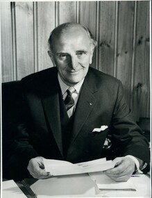
Photograph - Image, Howard Murray (Pat) Lightfoot, 1969
Howard Murray (Pat) Lightfoot (1904-1991) served as President for the Association for the Blind in 1952-1954 and 1964-1972 respectively. He joined the Association in 1938 as a sighted member of the General Committee, and was part of the group that dealt with the breakdown of a uneasy financial agreement that existed between the RVIB and AAB, the incorporation of the AAB under the Charities Act and the development of a rehabilitation centre at Kooyong for those who wished to have support without a residential component. After losing his father at an early age, Pat Lightfoot began working as an office boy for Nicholas Pty Ltd, later studying and becoming an accountant - such skills highly needed by the newly incorporated Association. According to 'No Sight, Great Vision', he was a highly skilled communicator, whose friendly and approachable manner won over most of those who opposed his presence on the general committee due to his sight. His support for and recognition of the work done by Mr Paterson led to him standing aside for the position of President and nominating his friend until the Committee overrode him in 1952. His appointment signaled a change in how the organisation was run, and introduced John Wilson as Secretary as well as Stan Horsfall as Treasurer in 1953, which helped move the administration style from social volunteering to business thinking. Health concerns caused him to resign in 1954, however when his health improved he rejoined the Committee in 1958 and again became a key worker in keeping the organisation financially healthy. The "H.M. Lightfoot Centre" - a two storey building attached to Paterson Hall was named after him. This image was provided when J Balmain was approached to paint a portrait of Mr Lightfoot, for the centenary celebrations of the AFB, as per the letter.1 portrait photograph of Howard (Pat) Lightfoot and 1 associated letter regarding usage for a portrait by Balmain.Mr H.M. (Pat) Lightfoot - (Past President) 1" Deep (No. 2) Association for the Blind 7 Mair Street Brighton Beach, 3188 Please return to PR Department (arrow pointing to left) 14 ems (arrow pointing to right) 1.95 .1 100# Ticket No: 5230 Client: Abaris 100# Wanted: Tues 19th AM Mounted: as layout and sticker 43 1/4% Please Quote No: BA 9105 Laurie Richards 4 Tower Ave, Alphington 3078 489-8528 48-5541h.m. lightfoot, association for the advancement of the blind, association for the blind -
 Vision Australia
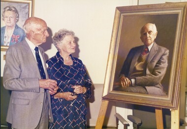
Photograph - Image, Pat and Beth Lightfoot, 1985
Howard Murray (Pat) Lightfoot (1904-1991) served as President for the Association for the Blind in 1952-1954 and 1964-1972 respectively. He joined the Association in 1938 as a sighted member of the General Committee, and was part of the group that dealt with the breakdown of a uneasy financial agreement that existed between the RVIB and AAB, the incorporation of the AAB under the Charities Act and the development of a rehabilitation centre at Kooyong for those who wished to have support without a residential component. After losing his father at an early age, Pat Lightfoot began working as an office boy for Nicholas Pty Ltd, later studying and becoming an accountant - such skills highly needed by the newly incorporated Association. According to 'No Sight, Great Vision', he was a highly skilled communicator, whose friendly and approachable manner won over most of those who opposed his presence on the general committee due to his sight. His support for and recognition of the work done by Mr Paterson led to him standing aside for the position of President and nominating his friend until the Committee overrode him in 1952. His appointment signaled a change in how the organisation was run, and introduced John Wilson as Secretary as well as Stan Horsfall as Treasurer in 1953, which helped move the administration style from social volunteering to business thinking. Health concerns caused him to resign in 1954, however when his health improved he rejoined the Committee in 1958 and again became a key worker in keeping the organisation financially healthy. The "H.M. Lightfoot Centre" - a two storey building attached to Paterson Hall was named after him. In these three photographs Pat and his wife Beth look or stand next to the portrait painted of Pat Lightfoot, for the centenary celebrations.3 coloured photographs of Pat and Beth Lightfooth.m. lightfoot, association for the blind -
 Eltham District Historical Society Inc
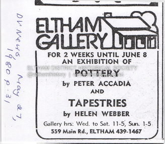
Document - Property Binder, 559 Main Road, Eltham
Newspaper advertisement: Diamond Valley News, 27 May 1980, Exhibition, Peter Accadia, pottery, and Helen Webber, tapestries. Newspaper article: Five for the price of one, Diamond Valley News, Tuesday, July 8, 1986, p27; exhibition of five artists at Eltham Gallery. On reverse, numerous advertisements for food and entertainment Newspaper advertisement: The Age ,17 June 1989, Exhibition, Donald Ramsay "Watching the river flow". Newspaper article: Landmark gallery says goodbye, Diamond Valley Leader, 24 November 2004, Gallery site sold to Sentinel Equities, present tenant Julie Skate, quotes from former part-owner Val Murray. Newspaper article: Rift over gallery plans, Diamond Valley Leader, 21 February 2007, purchasers Jethro Tull and Suzanne Still plan to build offices, gallery and cafe; Eltham Gateway Action Group objected while supporting need for a gallery elsewhere. Newspaper article: New try for gallery-cafe ready soon, Diamond Valley Leader, 18 April 2007, purchaser Jethro Tull to have a new plan ready in two weeks for gallery and cafe. Newspaper article: Gateway for artists, Diamond Valley Leader, 25 May 2007, Jenni Mitchell opened a new gallery pending decision by Nillumbik Council. Newspaper article: Art gallery proposal rejected, Diamond Valley Leader, 30 May 2007, Nillumbik Council against planned new building. Newspaper article: Artful win for gallery, Diamond Valley Leader, 30 January 2008, VCAT approved mudbrick art gallery. Newspaper article: Rocky road to create a landmark, Diamond Valley Leader, 13 February 2008, VCAT approved Robert Marshall's design, artists's impression, Eltham Gateway Action Group opposed.main road, property, businesses, eltham gallery, wiregrass gallery, eltham gateway action group, robert marshall, mud brick building, eltham (vic), 559 main road eltham, artists, bernhard rust, bob smith, jan neil, john adams, marian sussex, michael wilson, tony dopheide, 47-55 main street diamond creek, 50 were street montmorency, 55 rattray road montmorency, 410 main road lower plenty, abbey of diamond creek, adams north riding restaurant, advertising, eltham barrel, montmorency, mustard seed restaurant, peking house restaurant, st andrews, tamara's -
 Eltham District Historical Society Inc
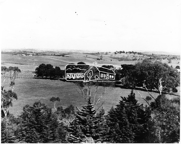
Photograph, View of Kangaroo Ground District from War Memorial Tower, 16 November 1951, 16 Nov. 1951
View from Shire of Eltham War Memorial tower at Garden Hill, Kangaroo Ground, probably taken shortly after the memorial's re-dedication held 8 Nov. 1951. On November 11th 1926 the Shire of Eltham War Memorial Tower at Kangaroo Ground was opened. It is regarded as one of Melbourne’s most outstanding lookout towers. It commands a magnificent 360 degree panorama from Kinglake across the Diamond Valley to Macedon and the You Yangs. It is built on a peak which was once a volcano, 237 metres above sea level. After World War one a memorial cairn was erected on the site, and in 1925 a committee of public-minded citizens began to plan for a tower. Many generous donations of material and money were forthcoming so that in 1926 the Governor General Lord Stonehaven was able to unveil the plaque before a crowd of 500 people There was some concern in the 1960s when the Forests Commission wanted to build a firespotters cabin on the top. At first R.S.L. branches opposed the idea, but it was realised that this use could combine with its use as a tourist attraction, and would ensure its maintenance for the future. Today the Kangaroo Ground tower provides one of the best views around Melbourne and is a fitting memorial to those who died in two world wars. From: Historic items for Diamond Valley Community Radio September 1990 (EDHS collection) On November 8th, 1951, the memorial was re-dedicated by the Governor of Victoria, Sir Dallas Brookes with the addition of the names of men from the Shire of Eltham who fell in the Second World War. Further wreaths were added in time for the 2001 Reembrance Day service to commemorate the men from th shire who had fallen in the Malayan, Korean, Borneo and Vietnam campaigns.This photo forms part of a collection of photographs gathered by the Shire of Eltham for their centenary project book,"Pioneers and Painters: 100 years of the Shire of Eltham" by Alan Marshall (1971). The collection of over 500 images is held in partnership between Eltham District Historical Society and Yarra Plenty Regional Library (Eltham Library) and is now formally known as the 'The Shire of Eltham Pioneers Photograph Collection.' It is significant in being the first community sourced collection representing the places and people of the Shire's first one hundred years.Digital image 120 format B&W negative B&W Print 12.5 x 17.5 cmsepp, shire of eltham pioneers photograph collection, kangaroo ground, garden hill, kangaroo ground tower, lookout, memorial park, panorama, shire of eltham war memorial, view, vista -
 St Kilda Historical Society
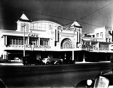
Photograph, St Moritz St Kilda - images collection #1, c1940s
The St. Moritz Ice Rink was a popular ice skating rink on The Esplanade, St. Kilda, Victoria. It operated between 1939–1981. As one of only two ice rinks in Melbourne in the 1940s and 1950s, it played a central role to the sport of ice hockey in Australia. Closed in 1982, it soon suffered a major fire and was then demolished, an event later seen as a major blow to the heritage of St Kilda. It was first built as the Wattle Path Palais de Danse in 1922, a very large dance hall, designed by architects Beaver & Purnell, The Wattle Path was the venue for the first all-Australian dance championship, and featured some of the best dance bands of Australia, as well as from America. Popular throughout the 1920s, it suffered due to the Great Depression, and closed in the early 1930s. From 1933-1936 the building became a film studio, Efftee Studios, for Frank W. Thring. In 1938, businessman Henry Hans "Harry" Kleiner announced that the Wattle Path would become an ice rink. He was sole proprietor until 1953, when he sold the business to J. Gordon and T. Molony, both champion skaters. Trade declined during the 1970s. The building was sold in 1980 to developers Hudson Conway and trucking magnate Lindsay Fox and was closed in early 1982. It was nominated to the Historic Buildings Preservation Council, but a majority of City of St Kilda councillors voted to oppose this action and uphold a demolition permit already issued. The building infamously suffered a fire later that year, leaving only the facades, which were demolished soon after. The site remained vacant until about 1991, when a mid-price hotel called the St Moritz was constructed. By 1993 it was simply called the Novotel St Kilda. The hotel closed in 2019 and was replaced by an apartment complex.black and white photographSt Moritz, St Kilda. Ice Skating. Caf�st moritz, st kilda, the esplanade, ice skating -
 Uniting Church Archives - Synod of Victoria
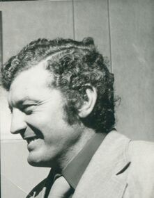
Photograph, Brian Dixon, Undated
Brian James Dixon (born 20/05/1936) is a former Australian rules footballer and Victorian politician. Dixon played 252 VFL games for Melbourne between 1954 and 1968, playing mostly on the wing. He had a stellar football career, playing in five premierships, winning Melbourne's best and fairest in 1960, while in 1961 he was selected in the All-Australian team and he also won the Tassie Medal for his performances at the 1961 Brisbane Carnival. In 2000 he was named in Melbourne's Team of the Century. Despite still playing football for Melbourne, he entered parliament in 1964, as the member for the now abolished seat of St Kilda, representing the Liberal Party. Being from the moderate wing of the party he clashed with then Premier Henry Bolte, especially over the hanging of Ronald Ryan which Dixon strongly opposed.[1] After Rupert Hamer took over as Liberal Party leader and Premier, Dixon was promoted to the ministry. He variously served in several portfolios including youth, sport and recreation, housing and Aboriginal affairs. His most remembered achievement was introducing the iconic Life. Be in it. program.[2] In 1979 Dixon won St Kilda by an extremely narrow margin, which crucially gave the Hamer Liberal government a majority of one seat in the Legislative Assembly and meant that the Liberal Party did not need to form a Coalition with the National Party with whom relations were traditionally poor in Victoria. However, in 1982 Dixon was defeated as the Liberals lost government after 27 years in office. After his defeat, Dixon has worked predominantly in sports administration and he currently runs public speaking seminars. Brian currently travels the world representing TAFISA and ASFAA. He is also president of AFL South Africa and takes a keen interest in other countries playing Australian rules football.[3]B & W photograph of Brian Dixon in profile.dixon, brian, football, victorian parliament -
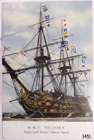 Flagstaff Hill Maritime Museum and Village
Postcard - Vessel, Sailing Ship, after October 1805
The British Royal Navy’s warship HMS Victory was once Lord Nelson’s flagship. The HMS Victory was built in 1765 and after serving active duty is now, in 2019, still a ship of the Royal Navy, in dry dock undergoing continuous restoration to preserve her for display as a museum ship, due to the vessel’s significant naval history. Battle of Trafalgar: On October 21, 1805, twenty-seven British ships of the line, led by Admiral Lord Nelson aboard HMS Victory, defeated thirty-three French and Spanish ships of the line under French Admiral Villeneuve. The battle took place in the Atlantic Ocean off the southwest coast of Spain, just west of Cape Trafalgar, near the town of Los Caños de Meca. The victory confirmed the naval supremacy Britain had established during the course of the eighteenth century and it was achieved in part through Nelson's departure from the prevailing naval tactical orthodoxy of the day. Conventional practice at the time was for opposing fleets to engage each other in single parallel lines, in order to facilitate signalling and disengagement and to maximise fields of fire and target areas. Nelson instead arranged his ships into two columns to sail perpendicularly into the enemy fleet's line. During the battle, Nelson was shot by a French musketeer and he died shortly before the battle ended. Villeneuve was captured, along with his ship Bucentaure. He later attended Nelson's funeral while a captive on parole in Britain. Admiral Federico Gravina, the senior Spanish flag officer, escaped with the remnant of the fleet. He died five months later from wounds sustained during the battle. It was prior to this battle that Nelson had issued his now-famous final orders to his ships in 12 separate flag-hoists “England expects that every man will do his duty”. This wood sample is historically significant for its association with Admiral Lord Nelson the Battle of Trafalgar. Through Nelson’s leadership and unorthodox battle tactics, he secured not only a victory against the French and Spanish but reaffirmed Britain's naval supremacy opening the way for Britain to continuing the policy of colonisation of many countries including Australia.A coloured postcard of a sailing ship, warship or battleship, deck cannons on the ship and in the foreground, many signal flags flying from the masts. Printed on the front "H.M.S. Victory Flying Lord Nelson Famous Signal". The signal was given by Lord Nelson in 1805.Printed on the front "H.M.S. Victory / Flying Lord Nelson Famous Signal"flagstaff hill, warrnambool, shipwrecked-coast, flagstaff-hill, flagstaff-hill-maritime-museum, maritime-museum, shipwreck-coast, flagstaff-hill-maritime-village, post card, postcard, sailing ship, vice-admiral lord nelson, horatio nelson, lord nelson, oak piece, piece of oak, nelson, battle of trafalgar, maritime technology, ship relics, 18th century warship, british royal navy, sir home popham’s telegraphic code, admiralty official day signal book, october 21, 1805, admiral lord nelson, french and spanish navies, nelson's famous signal, england expects that every man will do his duty, hms victory, nelson collection at lloyd's, lloyd’s of london, lloyd’s patriotic fund, napoleonic battles, british naval history, 18th century warship, 18th century battleship -
 Bendigo Historical Society Inc.
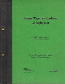
Book - BENDIGO SALEYARDS COLLECTION: SALARIES WAGES AND CONDITIONS OF EMPLOYMENT
Bright green hard covered book with a black spine and two brass screws to hold it together. Printed on the front cover is: Salaries Wages and Conditions of Employment. Steward's Copy. Federated Municipal and Shire Council Employees' Union of Australia. Address and R. Coles, General Secretary. 39 loose pages in the cover. Mentioned are various occupations and their weekly minimum wage, Definitions and conditions. Bright yellow flyer in book titled Workers' Compensation Rights and Benefits are Under Attack, Items mentioned are: Amending Bill, Why the Amendments were Opposed, Hamer Refused our Request, What the Government is Up To and the Fight is On. Blue hard covered book with a black spine and two brass screws to hold it together. Printed on the front cover is: Salaries Wages and Conditions of Employment. Steward's Copy. Federated Municipal and Shire Council Employees' Union of Australia. Address and R. Coles, General Secretary. Mentioned are various occupations and their weekly minimum wage, Definitions and conditions. Bright yellow hard covered book with a black spine and two brass screws to hold it together. Printed on the front cover is: MEU, Salaries Wages and Conditions of Employment. Steward's Copy. Federated Municipal and Shire Council Employees' Union of Australia. Address and p. Slape, General Secretary. Mentioned are various occupations and their weekly minimum wage, Definitions and conditions. There are a number of amendments. In the book is a flyer titled 'Do You pay too much tax?' Printed in red and black. It contains information on tax saving.bendigo, council, cattle markets, bendigo saleyards collection - salaries wages and conditions of employment, federated municipal and shire council employees' union of australia, r coles, victorian trades hall council, k c stone, industrial printing and publicity co. ltd., mr hamer -
 Supreme Court of Victoria Library
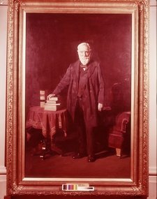
Portrait, John Schutt, Supreme Court Librarian, 1916/1917
This portrait was presented by the Victorian Bar to the Library in 1917 to commemorate Schutt’s fifty years as the Supreme Court Librarian. The portrait was presented at a ceremony presided over by Mr Mitchell KC who noted the “unanimity with which the members of the profession had adopted the suggestion that the eminent services of Mr Schutt should be recognised in this way.” Chief Justice Madden also spoke on this occasion and there were a number of judges and members of the legal profession present. John Schutt had been born in England in 1831 and migrated to Victoria as a young man, initially working as a school teacher he was appointed librarian, during Redmond Barry’s time in 1866. He started work in the Old Court in Russell street and would have supervised the move of the library to its new and greatly expanded premises in William Street in 1884. As well as secretary to the Library committee, he also acted as the Secretary of the Board of Examiners on occasion. After his death in 1919 in its obituary, the Williamstown Chronicle noted that Schutt was regarded as a Solon, an ancient greek law giver who gave wise advice. Away from the Court he was a councillor of many years standing in Williamstown, representing the Victoria Ward, what is now the suburb of Newport, it would appear Schutt street in Newport was named after him. His eldest son William Schutt was appointed a Supreme Court judge in 1919. The portrait of Schutt is a companion piece to the Sir Thomas a’Beckett picture painted shortly before the Schutt portrait and for the same client, they share the same frame design with gum leaf motif. This portrait was undertaken early in Meldrum’s career and before he had fully developed his theory of painting. Duncan Max Meldrum (1875-1955) was a controversial figure in his later years as he strongly opposed modernism and non-figurative art. His works are found in most of the state galleries, including a wide selection at the National Gallery of Victoria. This portrait is of interest for whom it portrays and as the work of a well known artistFull length portrait in oils of John Schutt. Schutt is standing up looking out the to the viewer. His hand rests on a small pile of books. He is dressed soberly in a three piece black suit. His white beard and hair all meticulously trimmed and realised. The props used in this painting provide the main colour as the background has become dark over the years. The books sit atop of a red and gold draped table. Behind Schutt is what appears to be a crimson velvet chair and he gives every appearence of having just arisen from the chair to engage with the viewer. The painting has an unusual light source at the foot of the painting with Schutt's legs providing shadows. Signed Meldrum lower right hand corner. Plaque inscription is John Schutt, Esq. Supreme Court Librarian -
 Seaworks Maritime Museum
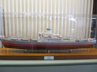
Shipbuilders model, Tri Ellis
Model ship was presented to the Melbourne Maritime Museum by the British Phosphate Commissioners. Built as Tri-Ellis (1958-74), Tryphena (1974-78), Man Tat (1978-80), 1980 broken up. DWT 13,756 SPEED 14 KNOTS.AT 112RPM. BOILERS LARKSON TRIMBLETUBE. FUEL CONSUMPTION 7 TPD. GENERATORS W.H.ALLEN - 4CYL.2SA290/470. 480B.H.P.320L.W.-220V 333RPM DAILY CONS - 1.5 TONS. EMERGENCY GEN R & H. 40 K.N. -220V. REFRIGERATING MACH: J & G HALL LTD. SUPERSTRUCTURE: FORECASTLE 62'..2 DECKS RIVETED AND WELDED. CARGO BATTONS NOT FITTED. 9 BULKHEADS. RISE OF FLOOR 6".WATER BALLAST 3,296 TONS INCLUDING TUNNEL TANKS 1,341 TONS. 'TWEEN- DECKS FORWARD 274 TONS. REFRIGERATED CARGO INSTALLATION - 6 HOLDS - 55.2',52',54',59.5',43' ,53'. GRAIN CAPACITY :621,640 CU. FT. BALE CAPACITY : 573,810 CU. FT. INSULATED CAPACITY : 5,050 CU.FT. 6 STEEL HATCHWAYS (27',30',30'* 30') (30'* 27.75') (27', 24' * 28' ). 12 WINCHES...DERRICKS 1 (25), 2 (10), 10 (5). MACHINERY: OIL 2SA 7CY.C20 * 1400MM EXHAUST 470MM. 6500 BHP. FUEL BUNKERS: 2135 TONS HIGH VISCOCITY FUEL. The main engine was an opposed piston type Harland & Wolff 6-620/ 1870 6 for the number of cylinders.. 620 for the cylinder bore and 1870 for the combined strokes of the main exhaust pistons in each cylinder. This engine was based no a Burmeister and Wain design but H & W gave these engines their own type designation. Sailed on board its maiden voyage to Australia via Casablanca Morocco where she collected her first load of phosphate. We sailed to Geelong via the Suez canal and the Port of Aden (Yemen) and Freemantle. The first load of phosphate was unloaded at Corio Bay (geelong) Formerly part of the collection of Melbourne shipping company, Howard Smith Ltd. Ship builder's model of the cargo ship Tri-Ellis IMO 5368196 - Body of moulded polyurethane painted in red, black and grey, the deck painted in red, with detailed fittings, machinery, rigging and superstructure, raised on a wooden base. Original ship built Clyde 1958, 11,761 gross tonnes, 531.5' x 68' x 31' (162.0 x 20.73 x 9.45m)plaque at foot of model "MV TRI ELLIS/ LENGTH B.P. 486'-3"- BREADTH MLD 68'0" - DEPTH MLD 40'6"/ TONNAGE GROSS 11,760/ Built by HARLAND & WOLFF LTD/ For BRITISH PHOSPHATE COMMISSIONERS" On model "TRI-ELLIS" painted black -
 City of Moorabbin Historical Society (Operating the Box Cottage Museum)
Document - Genealogy Chart Henry Dendy (Photocopy), 19 thC
In 1840 Henry Dendy, a farmer in Surrey, England acquired a "Special Survey" from the Commissioners for Land and Emigration which gave Dendy the right to choose land in Port Phillip for the "bargain basement" price of only £1 per acre for 5120 acres, (an area of 8 square miles). The Special Survey also included the right to "the shipment of a worker for every £20 spent on land, whose free passage was paid by the Crown, equalling a total of 100 workers ". Accordingly Dendy sold his English holdings and paid the required £5120 and arrived in Melbourne in February 1841. However by this time land in the new colony was selling for £5 - £40 per acre. Because Henry Dendy possessed the order from the Colonial Office in London he was able to successfully oppose Super-intendant LaTrobe's attempts to alter the price of the land. Dendy appointed Jonathan Were, (an entrepreneur, who had arrived in 1839), as his Manager and who later became a partner. Together, Dendy and Were decided on an area 5 miles south from Melbourne, bounded by North Road, East Boundary Road, South Road and to the west by Port Phillip Bay. Were and Dendy pitched their tents in the area now known as ' Park St, Brighton' and sank a well near the corner of 'St Andrew's St and Wells St'. By 1845 J.B Were and Company had bought almost half of Dendy's land and Were built himself "Moorabbin House" in Were St Brighton made from stone, quarried from local cliffs. It was still standing in 1924. Legend records Moorabbin is named after the Aboriginal word for ' Mother's Milk ' The soil is very fertile and well supplied with water especially in the area called 'East Brighton' - now known as Bentleigh and East Bentleigh - By 1850 the area had developed with numerous market gardens, dairy farms, fruit gardens and vineyards supplying food for the growing population of Melbourne.In 1840 Henry Dendy, a farmer in Surrey, England acquired a "Special Survey" from the Commissioners for Land and Emigration which gave Dendy the right to choose land in Port Phillip for the price of only £1 per acre for 5120 acres. This land was called Brighton in the Parish of Moorabbin, County of Bourke and emigrants developed the land establishing market gardens , dairy and poultry farms that provided the food for the growing population of Melbourne. A photocopy of the Genealogy Chart of the Dendy Family that Henry Dendy brought with him when he emigrated to Melbourne 1841Genealogy signs and descriptionsdendy henry, dendy's special survey brighton 1841, governor gipps, captain lonsdale, super-intendant latrobe, port phillip, melbourne, new south wales, squatters, emmigrants, county of bourke, parish of moorabbin, early settlers, pioneers, market gardeners, dairy farmers, fruit farms, moorabbin, bentleigh, brighton, cheltenham, were jonathan binn, -
 City of Moorabbin Historical Society (Operating the Box Cottage Museum)
Document, Henry Dendy family Shield
In 1840 Henry Dendy, a farmer in Surrey, England acquired a "Special Survey" from the Commissioners for Land and Emigration which gave Dendy the right to choose land in Port Phillip for the "bargain basement" price of only £1 per acre for 5120 acres, (an area of 8 square miles). The Special Survey also included the right to "the shipment of a worker for every £20 spent on land, whose free passage was paid by the Crown, equalling a total of 100 workers ". Accordingly Dendy sold his English holdings and paid the required £5120 and arrived in Melbourne in February 1841. However by this time land in the new colony was selling for £5 - £40 per acre. Because Henry Dendy possessed the order from the Colonial Office in London he was able to successfully oppose Super-intendant LaTrobe's attempts to alter the price of the land. Dendy appointed Jonathan Were, (an entrepreneur, who had arrived in 1839), as his Manager and who later became a partner. Together, Dendy and Were decided on an area 5 miles south from Melbourne, bounded by North Road, East Boundary Road, South Road and to the west by Port Phillip Bay. Were and Dendy pitched their tents in the area now known as ' Park St, Brighton' and sank a well near the corner of 'St Andrew's St and Wells St'. By 1845 J.B Were and Company had bought almost half of Dendy's land and Were built himself "Moorabbin House" in Were St Brighton made from stone, quarried from local cliffs. It was still standing in 1924. Legend records Moorabbin is named after the Aboriginal word for ' Mother's Milk ' The soil is very fertile and well supplied with water especially in the area called 'East Brighton' - now known as Bentleigh and East Bentleigh - By 1850 the area had developed with numerous market gardens, dairy farms, fruit gardens and vineyards supplying food for the growing population of Melbourne. dendy henry, dendy's special survey brighton 1841, governor gipps, captain lonsdale, super-intendant latrobe, port phillip, melbourne, new south wales, squatters, emmigrants, county of bourke, parish of moorabbin, early settlers, pioneers, market gardeners, dairy farmers, fruit farms, moorabbin, bentleigh, brighton, cheltenham, were jonathan binn, -
 City of Moorabbin Historical Society (Operating the Box Cottage Museum)
Document - Pedigree of Henry Dendy, c1840 Original ; Copy 1985
This is a copy of the document brought by Henry Dendy to the Colony in 1841. In 1840 Henry Dendy, a farmer in Surrey, England acquired a "Special Survey" from the Commissioners for Land and Emigration which gave Dendy the right to choose land in Port Phillip for the "bargain basement" price of only £1 per acre for 5120 acres, (an area of 8 square miles). The Special Survey also included the right to "the shipment of a worker for every £20 spent on land, whose free passage was paid by the Crown, equalling a total of 100 workers ". Accordingly Dendy sold his English holdings and paid the required £5120 and arrived in Melbourne in February 1841. However by this time land in the new colony was selling for £5 - £40 per acre. Because Henry Dendy possessed the order from the Colonial Office in London he was able to successfully oppose Super-intendant LaTrobe's attempts to alter the price of the land. Dendy appointed Jonathan Were, (an entrepreneur, who had arrived in 1839), as his Manager and who later became a partner. Together, Dendy and Were decided on an area 5 miles south from Melbourne, bounded by North Road, East Boundary Road, South Road and to the west by Port Phillip Bay. Were and Dendy pitched their tents in the area now known as ' Park St, Brighton' and sank a well near the corner of 'St Andrew's St and Wells St'. By 1845 J.B Were and Company had bought almost half of Dendy's land and Were built himself "Moorabbin House" in Were St Brighton made from stone, quarried from local cliffs. It was still standing in 1924. Legend records Moorabbin is named after the Aboriginal word for ' Mother's Milk ' The soil is very fertile and well supplied with water especially in the area called 'East Brighton' - now known as Bentleigh and East Bentleigh - By 1850 the area had developed with numerous market gardens, dairy farms, fruit gardens and vineyards supplying food for the growing population of Melbourne. A copy of a paper chart of the Pedigree of Henry Dendy in a wooden frame with glassPedigree / of the branch of the family / DENDY moorabbin, brighton, henry dend special survey 1841 y, early settlers, pioneers, market gardeners -
 Vision Australia
Document - Image, 1934 - 1954 - 50 Years of Talking Book Service, 1984
The Talking Book Library of the Royal Victorian Institute for the Blind is celebrating its 50th anniversary during 1984. This service began in 1934 with 78 rpm records. These were later superceded by 33rpm records which remained in use until 1960. The first cassettes were imported from England and weighed 7 lb. along with the player which weighed 28 lb. These 18 track cassettes usually contained one whole book. In the early 1970's a change was made to smaller cassettes containing 12 hours of recorded material on 6 tracks. The latest system currently being introduced is the Library of Congress 4 Track System utilising cassettes which play for 6 hours and machinery which is adaptable to the conventional 2 track system cassette. The Talking Book Library today provides services to 2500 readers as opposed to only 500 in 1964. The service is free of charge to anyone who is visually handicapped and includes talking books, talking book machines, mail service, servicing of machines at regular intervals and any modifications that may be required. Over 1600 cassettes are handled daily. The library currently holds over 3500 individual titles. Catalogues are available in print, audio and braille format. Once selection is made, borrowers may receive at least 3 books at any one time. Other services include current magazines, foreign language books, newspapers and magazines and regional country newspapers. Many books are recorded at the R.V.I.B. by our volunteer readers while others are bought from similar agencies in Australia and overseas. The department of the R.V.I.B. relies almost entirely on voluntary donations from the public. Other services provided by the Royal Victorian Institute for the Blind Community Resources Section, Aids & Equipment Shop, Tertiary Resource Service, Industrial Department, Retired Personnel Allowance, Children's Services, Social Services, Housing Loans, Vocational Development1 digital image of typewritten pageroyal victorian institute for the blind, talking books -
 Eltham District Historical Society Inc
Photograph - Digital Photograph, Marguerite Marshall, 'Worlingworth', 10-26 Banoon Road, Eltham, 30 January 2006
'Worlingworth', Eltham, home of noted anthropologist the late Professor Donald Thomson and his wife Dorita Thomson. Covered under Heritage Overlay, Nillumbik Planning Scheme. Published: Nillumbik Now and Then / Marguerite Marshall 2008; photographs Alan King with Marguerite Marshall.; p127 Dubbed as ‘Australia’s Lawrence of Arabia’ anthropologist Donald Thomson lived much of his life in Eltham, at Banoon Road. On his retirement as Professor of Anthropology in 1968, The University of Melbourne professorial board compared Thomson to Lawrence of Arabia because of his work for Aborigines and his controversial personality. Although Thomson is now recognised for his huge contribution, during his lifetime he suffered opposition and his life has been described as ‘tragic’.1 Thomson failed to gain the recognition as a scientist that he felt he deserved and he failed to alter government policy towards Aboriginal people. But towards the end of his life in 1970, anthropologists were moving towards the type of research he had done and the movement to grant land rights to Aborigines was strengthening. Thomson is best known for his anthropological fieldwork in Cape York, Arnhem Land and Central Australia, but he is also known for his scholarly contributions to ornithology and ecology. Thomson documented every aspect of the daily and ritual life of the Aboriginal world of Cape York and Arnhem Land in the 1930s and 1940s. The huge collection in Museum Victoria includes 11,000 photographs, 7500 items of material culture, 1000 botanical and zoological specimens and 4500 pages of field-notes.2 The film Ten Canoes used Thomson’s photographs as a source. Thomson bought the Eltham property known as Worlingworth in 1934. The single-storey 60-square house standing by the Yarra River was built in 1922-23. It is one of the last in Eltham to survive with its farm setting intact. It is also one of the few substantial residences built in the Eltham Shire from the late 19th century to the early 20th century, which signalled a major change in the area towards the residential municipality it is today.3 The original section, built in the mid 1860s, of rose pink hand-made bricks and stone quarried on the property, was incorporated in the new red-brick house built in 1922. An immense oak tree by the house grew from an acorn brought by Patrick Armstrong who first bought the land in March 14, 1862. Armstrong named Worlingworth after his forbears’ village in Suffolk, England. Worlingworth saw grand days when Commander Alan A Barlee (R.N.) bought it in 1922 after winning the Calcutta Sweep. The property then included a nine-hole golf course, a tennis court, a bowling green, a boathouse and a boat-ramp.4 For most of his career Thomson, who was born in 1901, was attached to The University of Melbourne. In 1935 he represented the Commonwealth Government at Caledon Bay in east Arnhem Land to investigate and mediate for four Aborigines accused of killing five Japanese and three Europeans. In 1938 Thomson was awarded a PhD in Anthropology at Cambridge University, and during his career, he received several medals from British Societies, who perhaps appreciated his work better than their Australian counterparts. From World War Two, Thomson suffered a string of hardships, beginning with severe wounding in Dutch New Guinea (for his military service in New Guinea he was awarded an OBE) and he was invalided from service in 1944. That year he was diagnosed with diabetes. A fire in 1946 destroyed what Thomson regarded as perhaps the best record he had made of Aboriginal life – the 20,000 feet, (6096m) of film he had shot in Arnhem Land. In 1954 he and wife, Gladys, divorced. The next year he married his technical assistant, Dorita McColl. Several times during his career Thomson had major disagreements. For instance Professor P Elkin constantly opposed his work. He also opposed Thomson when he campaigned vigorously in 1947 against the establishment of a rocket range at Woomera, South Australia, because of the threat it posed Aborigines. Thomson resigned in frustration from the Victorian Aborigines Welfare Board in 1967, after serving for ten years, because he found that his advice was disregarded. His ashes were scattered over Caledon Bay from the air.This collection of almost 130 photos about places and people within the Shire of Nillumbik, an urban and rural municipality in Melbourne's north, contributes to an understanding of the history of the Shire. Published in 2008 immediately prior to the Black Saturday bushfires of February 7, 2009, it documents sites that were impacted, and in some cases destroyed by the fires. It includes photographs taken especially for the publication, creating a unique time capsule representing the Shire in the early 21st century. It remains the most recent comprehenesive publication devoted to the Shire's history connecting local residents to the past. nillumbik now and then (marshall-king) collection, banoon road, donald thomson, dorita thomson, eltham, worlingworth -
 City of Moorabbin Historical Society (Operating the Box Cottage Museum)
Photograph - Map of Dendy's Special Survey, 1852 Map of Henry Dendy's Special Survey of 1841, 19th Century
A Map drawn in 1852 that shows the 5,120 acres that formed Dendy's Special Survey of 1841. In 1840 Henry Dendy, a farmer in Surrey, England acquired a "Special Survey" from the Commissioners for Land and Emigration which gave Dendy the right to choose land in Port Phillip for the "bargain basement" price of only £1 per acre for 5120 acres, (an area of 8 square miles). The Special Survey also included the right to "the shipment of a worker for every £20 spent on land, whose free passage was paid by the Crown, equalling a total of 100 workers ". Accordingly Dendy sold his English holdings and paid the required £5120 and arrived in Melbourne in February 1841. However by this time land in the new colony was selling for £5 - £40 per acre. Because Henry Dendy possessed the order from the Colonial Office in London he was able to successfully oppose Governor LaTrobe's attempts to alter the price of the land. Dendy appointed Jonathan Were, (an entrepreneur, who had arrived in 1839), as his Manager and who later became a partner. Together, Dendy and Were decided on an area 5 miles south from Melbourne, bounded by North Road, East Boundary Road, South Road and to the west by Port Phillip Bay. Were and Dendy pitched their tents in the area now known as ' Park St, Brighton' and sank a well near the corner of 'St Andrew's St and Wells St'. By 1845 J.B Were and Company had bought almost half of Dendy's land and Were built himself "Moorabbin House" in Were St Brighton made from stone, quarried from local cliffs. It was still standing in 1924. Legend records Moorabbin is named after the Aboriginal word for ' Mother's Milk ' The soil is very fertile and well supplied with water especially in the area called 'East Brighton' - now known as Bentleigh and East Bentleigh - By 1850 the area had developed with numerous market gardens, dairy farms, fruit gardens and vineyards supplying food for the growing population of Melbourne.This Map shows the birth of the Brighton and Moorabbin area. On 18th January1859 Brighton was proclaimed a Municipality and a Borough by October 1863. Meanwhile, following a Petition, the area of East and South Brighton, incorporating Mordialloc, Cheltenham, Mentone, Sandringham and Oakleigh separated from Brighton to form the Moorabbin District Roads Board becoming the first Local Government Authority. Col. William Mair was elected as the first Chairman of the Moorabbin Roads Board. Moorabbin Shire 1871 developed further and was declared a City in1934. The City of Moorabbin was the largest Municipality in Melbourne before the Amalgamation of Councils in 1994 when it was divided in the south to City of Kingston and in the north to City of Glen Eira A Photo-lithographed 1852 Map showing the 5,120 acres that formed Dendy's Special Survey of 1841. Henry Dendy & Jonathan Were chose an area 5 miles south from Melbourne, bounded by North Road, East Boundary Road, South Road and to the west by Port Phillip Bay. Moorabbin County of Bourke / Photo-Lithographed at the department of Lands and Survey. /Melbourne. / Price 1/- brighton, moorabbin, bentleigh, cheltenham, dendy henry, bent thomas, were jonathan, special survey -
 National Wool Museum
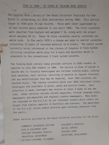
Textile - Community Textile Tapestry, Lisa Kendal et al, WARM, 2016
WARM was a community textile art project that saw over 250 knitters come together to create a beautiful collage tapestry. Made entirely from wool, the artwork contains more than 1000 individual hand knitted sections. The project takes aim at global warming, it highlights both the causes and solutions for us to create a sustainable and safe climate for future generations. Lisa Kendal, the co-creator of the project, said “One of the problems in the world is that we have forgotten how to warm ourselves with wool. We have become too dependent on fossil fuels (for heating)”. This is the key idea surrounding the project. WARM began as two large scale images created by Lars Stenberg. The first image is a landscape scarred by coal mining. The second image is the same landscape only many decades later. Regeneration and regrowth have taken over the landscape and hidden the past coal mine completely. In its place is a beautiful landscape including trees, native flowers, a lake, lots of greenery and wind turbines. From March to the end of August in 2016, knitters worked hard to create the over one thousand pieces that came together to form the final tapestry. The pieces were all designed by Fibre Artist Georgie Nicolson of Tikki Knitting Designs, who converted the second image of the healed landscape into patterns for the 250 plus knitters to follow. These patterns included unusual designs such as gum leaves, trees, native flowers and even the wind turbines. During several days of installation, the knitted pieces were stitched together by Lars Stenberg over a picture of the first image of the operational coal mine. They worked to create the second image of the renewed landscape; like an enormous collage. The WARM project was donated to the National Wool Museum in 2021. It was a much-loved hanging within the Ballarat Hospital for many years before coming to the museum. More information about the project can be found on the following website. http://www.seam.org.au/warm The tapestry is made from 1000+ hand knitted sections stitched together to make an image. In the foreground of this image is a large gum tree that stretches from the bottom left to the top right corner. The trunk of this tree follows the left edge of the tapestry, with foliage from the gum tree spanning its top border. The bottom third of the tapestry is predominantly green grass with yellow, pink and red flowers providing sporadic colour. The middle third encompasses a lake, with orange colours surrounding the banks of the water as opposed to the green grasses of the bottom third. To the right of the lake are wind turbines. The top third of the tapestry is blue sky with white clouds. It also contains the previously described gum tree leaves. Each piece of the tapestry is 100% wool and was hand knitted and stitched together. The Tapestry is accompanied by an oil painting on canvas. It is a painting that matches the tapestry and served as a template for the final tapestry. Finally, the tapestry is accompanied by another pointing on wood board. This final panting is of a coal mine. This is the setting before regeneration and regrowth have reclaimed this site, which is the theme captured in the final tapestry. In the foreground of the coal mine painting is the same gum tree described in the tapestry; however, it is grey and sickle with only 4 leaves visible at the top border, compared to the numerous leaves in the tapestry. Also in the foreground is a broken barb wire fence adding to the unwelcoming nature of the site. The colour scheme of this image is of dark greys and browns. A coal fired power plant can be seen in the final third of the image with four chimneys emitting plumes of smoke into the sky. In front of this power plant is the spiral shape of a coal mine, burrowing deep into the earth’s crust. Inside of the coal mine 3 yellow trucks are seen mining and transporting coal to the top of the mine.warm, community textile tapestry, knitting, community artwork, global warming -
 Ballarat Tramway Museum
Newspaper, State Electricity Commission of Victoria (SEC) and The Courier Ballarat, Tram future rests with Government, Feb. 1962
Yields information about the views of various letter writers, views of the Courier, union views, rehabilitation costs Geelong, public meetings and meetings with SEC.Set of three Foolscap sheet of plain paper, with rounded corners, with newspaper cuttings, concerning the mooted closure of the Ballarat Tram system 20 Feb and 22 Feb 1962. All from The Courier, unless noted otherwise. 7940.1 1 - "Tram future rests with Government" - 22-2-62 - news report about the SEC being insistent on tabling the motion to close in Parliament, price of replacement trams. Attending Mr K L Murray, Mr Linaker, Mr A V Mawby of the SEC, Cr. A Pittard and Town Clerk Mr. H H Maddern. 2 - "Government "Bought itself out" - continuation from above, quoting Mr Mawby about the rehabilitation of the system in 1934 by the Government, discussions about fares, losses, time of travel from Sebastopol compared to buses. Also notes Cr Tuppen of Sebastopol. 3 - "A hot tram tip" - 22-2-62 - suggestion by Cr Cooper suggested the tram be retained around the lake for Historical reasons, Mr Murray of the SEC, sell/give to the Historical Society, Cr W E Roff replied about not wanting them and put them in a tip. 7940.2 1 - "SEC Not to sell this - 20-2-62 - photo of the power house in Ripon St, with the caption that the SEC did not propose to sell the property, but would be selling the tram depot site. 2 - "The talk was trams" - 22-2-62 - photo of Mr Mawby, Cr A D Mason, H Linaker and Mr K L Murray at the meeting with Council the previous day. 3 - "Save our Trams" - 21-2-62 - long letter - about the closing the trams and railway losses including building, new rail lines being built. 4 - "Tram fight" - letter by R Courtney Union Secretary, about the formation of a Committee to oppose closure. 7940.3 "Sound Shell Plan+ - 21-2-62 - Long editorial about the construction of a Sound Shell and council discussions and inability to make a decision.closure, letter to the editor, editorial, sec, rehabilitation, staff, buses, concession fares, museum, power station, ballarat a power station, botanical gardens -
 Bendigo Military Museum
photograph - Cartographic Squadron Production – Army Survey Regiment, Fortuna, c1980
This collection of 12 photos was most likely taken in 1980. The photos were most likely taken in Cartographic Squadron’s Ante Room, the Attic and small offices on the top floor of Fortuna Villa. The computer based Editwriter typesetting system was introduced in 1975 as a replacement to the aging Fotosetter machine. It was operated by a specialised technician, who generated a large variety of map type styles and sizes quickly and reliably, as well as text panels. CPL Richards performed this task for several years and in photo .1P and .2P is reading off a type order next to the computer monitor. Output on Copy proof adhesive backed stripping type film replaced messy wax and spray adhesives in 1978. The Editwriter capability supported all RASvy units and contractor type setting requirements. Scribing was the cartographic process of drafting features such as drainage, relief, vegetation, roads and culture on specially coated map reproduction material. The cartographic technician scribed out the map feature such as a contour to a specified line width on the map sheet, using a tool affixed with a sapphire tipped cutter. The quality control edit (Proving) stage of map production was the first opportunity to inspect a proof of the map independently and systematically. Proving tasks were carried out by technicians conversant of the map product specification and task requirement, however, was not involved in its production. Corrections were identified, marked up and sent to back to the correcting section or contractors. Terrain Embossing was a manual map production technique to produce hill shading on medium to small scale graphics and air charts. SPR John Martin is seen in photos .8P to.10P using a fine embossing metal stylus to push down on the drainage impression on a thin malleable opaque plastic material (AK Poligraphy). Ridge lines were then pushed down using the contour impression as a guide, on the opposing side of the AK Poligraphy to create a 3D plastic model terrain effect. The map impression was sprayed with white paint and photographed to create a contone tone hill shade. SPR Gina (Coore) Neilson is seen in photo .11P washing a contone positive of a land mass in a solution. The contone components were registered to the map sheet, as shown in photo .12P and masked using an air brush and a halftone negative was then created. The terrain embossing method of producing hill shading was more efficient to produce than previous specialised artistic methods such pencil/eraser and air brush. Furthermore, a more consistent enhancement of terrain on charts was achieved between technicians.This is a set of 12 photographs of Cartographic Squadron performing four map production tasks at the Army Survey Regiment, Fortuna, Bendigo c1980. The first ten photographs were on 35mm negative film and were scanned at 96 dpi. Photos .11P and .12P were on photographic paper and scanned at 300 dpi. They are part of the Army Survey Regiment’s Collection. .1) - Photo, black & white, c1980, Editwriter typesetter, CPL Paul Richards. .2) - Photo, black & white, c1980, Editwriter typesetter, CPL Paul Richards. .3) - Photo, black & white, c1980, Scribing contours on a RAAF Chart, SPR Megan (McBurney) Reynolds. .4) - Photo, black & white, c1980, Scribing contours on a RAAF Chart, SPR Megan (McBurney) Reynolds. .5) - Photo, black & white, c1980, Scribing contours on a RAAF Chart, SPR Rod Skidmore. .6) - Photo, black & white, c1980, Scribing contours on a RAAF Chart, SPR Rod Skidmore. .7) - Photo, black & white, c1980, Formal quality control edit (Proving), CPL Ian Belmont. .8) - Photo, black & white, c1980, Hill Shade Terrain Embossing, SPR John Martin. .9) - Photo, black & white, c1980, Hill Shade Terrain Embossing, SPR John Martin. .10) - Photo, black & white, c1980, Hill Shade Terrain Embossing, SPR John Martin. .11) - Photo, black & white, c1980, Hill Shade Terrain Embossing, SPR Gina (Coore) Neilson. .12) - Photo, black & white, c1980, Hill Shade Terrain Embossing, unidentified..1P to .10P No personnel are identified. .11P and .12P annotated ‘Terrain Embossing’royal australian survey corps, rasvy, army survey regiment, army svy regt, fortuna, asr, carto -
 Eltham District Historical Society Inc
Photograph, Shire of Eltham War Memorial, Memorial Park, Garden Hill, Kangaroo Ground; Eltham Heritage Tour, 24 May 1992, 24/05/1992
ELTHAM HERITAGE TOUR The Society excursion on 24th May 1992 was arranged by David Bick, leader of the team carrying out the Shire's heritage study. David selected a number of sites or buildings identified in the study, some of them lesser known components of the Shire's heritage. The tour commenced at the Eltham Shire Office at 10.00 am. Travel was by private car and mini-bus with stops at about twelve locations for commentary by David.It included a short walk in Hurstbridge and lunch at Kinglake. Highlights of the tour included: - 10 am Leave from Shire Offices - 3 Important Trees - A Physical Link to Eltham's First Settlers - Toorak Mansion Gates - A Surviving Farm House - An Intact Circa 1900 Main Street - First Settlers - Gold Miners, and Timber-getters - An Early Hotel - A Pioneering Homestead - Changing Eltham Shire - 20th Century - 4 pm Afternoon Tea and Finish Tour Extract from ELTHAM CULTURAL HERITAGE TOUR (Newsletter No. 85, July 1992, by Bettina Woodburn) "Now we drove through stands of pines to the Kangaroo Ground Lookout Tower, a most unusual War Memorial, World War I. The tower and a shed/residence (it had a chimney) were built from local sandstone. Below to the south and east of Melbourne spread 'suburbia'. Close by the landscape seemed so contrived - English fields and hedgerows! Although only about twenty inches deep, the soil of this ancient volcano, its crater lost under subsequent weathering, was rich, deserving the name of "Garden Hill". Now native trees are taking over again. In Kangaroo Ground itself stand the inevitable Store, School and Church - and two Norfolk pines and a monkey puzzle tree." On November 11th 1926 the Shire of Eltham War Memorial Tower at Kangaroo Ground was opened. It is regarded as one of Melbourne’s most outstanding lookout towers. It commands a magnificent 360 degree panorama from Kinglake across the Diamond Valley to Macedon and the You Yangs. It is built on a peak which was once a volcano, 237 metres above sea level. After World War one a memorial cairn was erected on the site, and in 1925 a committee of public-minded citizens began to plan for a tower. Many generous donations of material and money were forthcoming so that in 1926 the Governor General Lord Stonehaven was able to unveil the plaque before a crowd of 500 people. There was some concern in the 1960s when the Forests Commission wanted to build a firespotters cabin on the top. At first R.S.L. branches opposed the idea, but it was realised that this use could combine with its use as a tourist attraction, and would ensure its maintenance for the future, Today the Kangaroo Ground tower provides one of the best views around Melbourne and is a fitting memorial to those who died in two world wars. From: Historic items for Diamond Valley Community Radio September 1990 (EDHS collection) Record of the Society's history and activities and highlighting various aspects of the Heritage Study undertaken by David Bick used to create the future heritage overlay for the Shire of Eltham and later Nillumbik Shire.Roll of 35mm colour negative film, 4 stripsKodak Gold 100 5095culture, events, garden hill, kangaroo ground, kangaroo ground memorial, memorial park, shire of eltham war memorial tower, war memorials -
 Uniting Church Archives - Synod of Victoria
Photograph, Undated c.1880s
Born 1823 West Indies, commenced ministry 1847, died 1890 in Rookwood, NSW. Joseph Horner Fletcher (1823-1890), Wesleyan minister, was born at St Vincent, Windward Islands, the eldest son of Rev. Joseph Fletcher, Wesleyan missionary, and his wife Mary, née Horner. In 1830-37 he attended a Methodist school in Kingswood, England, and then his uncle's school in Bath. He entered business but in July 1842 became a local preacher. He was accepted for the Wesleyan ministry in 1845 and after training at Richmond College, Surrey, he married Kate Green in December 1848. He was sent to Auckland, New Zealand, where he became the founding principal of Wesley College. In 1856 poor health obliged him to take up circuit work in Auckland and New Plymouth, where he witnessed the Maori war. He moved to Queensland and in 1861-64 was on circuit in Brisbane. In 1863 he became the first chairman of the Queensland Wesleyan District. In 1865 Fletcher was serving at Ipswich when invited to succeed Rev. John Manton as president of Newington College, Sydney. He acknowledged that the main business of the school was secular education in a Christian atmosphere and believed that education could help to overcome sectarianism. He invited distinguished academics to examine Newington students and strongly supported (Sir) Henry Parkes's education policies. He opposed the formation of a Methodist university college until a strong secondary school was established. He believed that boys should be taught to appreciate orderly conduct rather than to fear punishment and that corporal punishment was degrading and to be used only in extreme circumstances. Under Fletcher Newington developed a high moral tone and a tradition of order and respect. After he retired in 1887 the old boys gave him an address of appreciation and a portrait in oils to be hung in the hall. In addition to his normal duties from 1883 he had taught resident theological students. From 1887 he was an effective and progressive full-time theological tutor. As a preacher Fletcher had exceptional power: he expressed his thoughts in a fresh way with sparkling illustrations and characteristic humour. He combined humility with great spiritual power, prophetic vision and administrative ability. He encouraged the development of institutional church work which grew into the Central Methodist Mission in Sydney. Fletcher was elected as the first president of the New South Wales and Queensland Wesleyan Methodist Conference in 1874 and again in 1884, when he was also president of the General Conference of the Australasian Wesleyan Methodist Church. As conference editor in 1868, 1871 and 1873, Fletcher contributed more than fifty articles, numerous essays and reviews of books to the Weekly Advocate. He read widely, deeply and with discrimination. Never robust in health, he suffered months of illness before he died aged 66 at Stanmore, Sydney, on 30 June 1890. He was survived by three sons and two daughters, and buried in the Wesleyan section of Rookwood cemetery. In 1892 his eldest son, Joseph, edited a memorial edition of his Sermons, Addresses & Essays. Information from Australian Dictionary of Biography, Vol. 4, 1972. Sepia toned carte de visite. Seated studio portrait of the Rev. Joseph Fletcher.Rev Joseph Fletcherrev. joseph fletcher, joseph horner, wesleyan minister, newington college sydney, new zealand, queensland, president general conference, wesleyan methodist church, central methodist mission -
 Eltham District Historical Society Inc
Document - Folder, Ron F. McCormack, Appeal against Eltham Shire Permit granted for a propsed Youth Enterntainment Centre, 41-43 Were Street, Montmorency, 1993-1994
In 1993 Eltham Shire Council issued a permit to Michael Muzur, Terry Lant and Andrew McMillan to redevelop the former Montmorency Theatre/Bingo Hall at 41-43 Were Street as an alcohol-free youth entertainment centre. Ron McCormack, retired former JP on behalf of 41 Joint Appellants consisting of local residents and traders successfully lobbied the community and won an Appeal to have the permit cancelled as unsuitable development. The Administrative Appeal Tribunal found that the proposed development came withing the Eltham Planning Scheme definition of an 'amusement parlour' and that the playing of pool an amusement machines would be the focus of the centre and unlikely to attract older age groups. The tribunal was not satisfied the applicants had sufficient knowledge or where with all required for the successful running of this type of operation. With respect to the objectors, the Tribunal did not accept that a responsibly managed and attractive amusement parlour could not coexist near the adjoining residential area and without detriment to the commercial centre. At a Council meeting on June 7, 1994 councillors requested a report outlining criteria to be used to assess planning applications for youth entertainment venues given the Tribunal's view that a poorly managed facility in a small neighbourhood shopping centre, particularly in such close proximity to a residential area would not only have the potential to increase perceived youth problems, but could jeopardise the prospects of future proposals. Ron McCormack moved to Montmorency from Coburg in the early 1980s and from then sat on the bench at Eltham Courthouse when Police requested assistance out of hours, until the eventuial closure of the Courthouse. montmorency theatre, montmorency bingo hall, 41-43 were street, youth entertainment centre, eltham shire council, planning permit, administrative appeals tribunal, ron f mccormack